BODC Cruise Metadata Report for RRS Discovery (74E3) cruise D102_1
Introduction
This report collates information from the BODC cruise inventory and oceanographic databases. It presents
- Cruise Inventory Information
- A summary of BODC data holdings for the cruise from the
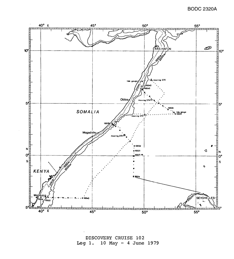
- References - including cruise tracks and cruise reports
Cruise Inventory Information
| Long name | RRS Discovery (74E3) cruise D102_1 |
|---|---|
| Short name | D102_1 |
| Objectives and Narrative |
The objectives of this two-leg cruise were:
(a) To contribute to mapping the Somali Current and offshore eddies at its time of maximum development. (b) To examine the vertical structure of the Somali Current and its relationship to sub-surface equatorial jets. This leg studied the current through XBT, CTD, water bottle and lowered current meter sections perpendicular to the Somalian and Kenyan coasts and deploying and tracking neutrally buoyant floats. Current meter and tide gauge moorings plus two FGGE buoys were deployed.. |
| Ship | RRS Discovery |
| Departure Port | Victoria, Seychelles |
| Departure Date | 1979-05-10 |
| Arrival Port | Mombasa, Kenya |
| Arrival Date | 1979-06-04 |
| Principal Scientist(s) | John C Swallow (Institute of Oceanographic Sciences Wormley Laboratory) |
| Responsible Organisation | Institute of Oceanographic Sciences Wormley Laboratory |
| Associated Project(s) | FGGE-INDEX |
| IHB Sea Areas Visited | Indian Ocean |
| Marsden Squares Visited | 31;1/31;3/32;2/32;4/331;1/331;2 |
| Work Area Description | |
| Unable to lookup cruise bounds at this time | |
| Work Area Bounding Polygon | |
| Southern Limit | unknown |
| Northern Limit | unknown |
| Western Limit | unknown |
| Eastern Limit | unknown |
Cruise Inventory Datasets
| Physical oceanography | |
|---|---|
| Bathythermograph |
Quantity:
number of profiles =
164
Description: XBT |
| CTD stations |
Quantity:
number of stations =
34
Description: |
| Current meters |
Quantity:
number of profiles =
39
Description: VAECM profiling current meter |
| Currents measured from ship drift |
Quantity:
138
Description: |
| Neutrally buoyant floats |
Quantity:
number of deployments =
31
Description: |
| Other physical oceanographic measurements |
Quantity:
21
Description: Doppler shear profiles |
| Surface measurements underway (T,S) | Description: Temperature only |
| Water bottle stations |
Quantity:
number of stations =
30
Description: |
| Chemical oceanography | |
| Oxygen |
Quantity:
30
Description: Bottle stations |
| Phosphate |
Quantity:
30
Description: water bottle stations |
| Silicate |
Quantity:
30
Description: water bottle stations |
Cruise Inventory Mooring/Buoy Operations
| Latitude | Longitude | Data type | Description |
|---|---|---|---|
| 7° 18' N | 50° 39' E | Current meters | current meter mooring with 3 RCMs deployed |
| 3° 57' N | 50° 3' E | Current meters | current meter mooring with 4 RCMs deployed |
| 5° 40' N | 50° 24' E | Current meters | current meter mooring with 4 RCMs deployed |
| 2° 0' N | 48° 3' E | Current meters | current meter mooring with 4 RCMs deployed |
| 7° 9' N | 49° 49' E | Sea level (inc. bot. press., inverted echosounder) | sea-floor tide gauge deployed |
| 4° 13' N | 52° 52' E | Sea level (inc. bot. press., inverted echosounder) | sea-floor tide gauge deployed |
| 0° 31' S | 49° 0' E | Surface drifters/drifting buoys | FGGE buoy deployed |
| 0° 59' N | 49° 0' E | Surface drifters/drifting buoys | FGGE buoy deployed |
Summary of BODC Data Holdings for the Cruise
National Oceanographic Database
Summary
| # Series | Instrument Description | Parameters |
|---|---|---|
| 26 | CTD/STD cast |
Salinity of the water column Temperature of the water column Vertical spatial coordinates |
Note: Parameter terms are taken from the BODC Parameter Discovery Vocabulary XML (SKOS)
Full List
| BODC Reference | Instrument Description | Date/Time | Location | |
|---|---|---|---|---|
| 55326 | CTD/STD cast | 1979-05-17 17:54Z | 2° 1' N, 48° 6' E | Click for more |
| 55338 | CTD/STD cast | 1979-05-18 09:28Z | 2° 27' N, 47° 41' E | Click for more |
| 55351 | CTD/STD cast | 1979-05-19 10:27Z | 2° 51' N, 47° 17' E | Click for more |
| 55363 | CTD/STD cast | 1979-05-19 22:20Z | 2° 58' N, 47° 3' E | Click for more |
| 55375 | CTD/STD cast | 1979-05-20 01:47Z | 3° 4' N, 46° 57' E | Click for more |
| 55387 | CTD/STD cast | 1979-05-22 09:15Z | 4° 1' N, 53° 1' E | Click for more |
| 55399 | CTD/STD cast | 1979-05-22 22:27Z | 4° 27' N, 52° 17' E | Click for more |
| 55406 | CTD/STD cast | 1979-05-23 10:08Z | 4° 49' N, 51° 44' E | Click for more |
| 55418 | CTD/STD cast | 1979-05-23 20:42Z | 5° 3' N, 51° 23' E | Click for more |
| 55431 | CTD/STD cast | 1979-05-24 13:02Z | 5° 19' N, 50° 54' E | Click for more |
| 55443 | CTD/STD cast | 1979-05-24 20:05Z | 5° 43' N, 50° 25' E | Click for more |
| 55455 | CTD/STD cast | 1979-05-25 12:53Z | 6° 6' N, 50° 0' E | Click for more |
| 55467 | CTD/STD cast | 1979-05-26 11:10Z | 6° 21' N, 49° 50' E | Click for more |
| 55479 | CTD/STD cast | 1979-05-26 20:25Z | 6° 25' N, 49° 44' E | Click for more |
| 55480 | CTD/STD cast | 1979-05-27 11:22Z | 6° 41' N, 49° 42' E | Click for more |
| 55492 | CTD/STD cast | 1979-05-31 10:25Z | 4° 4' S, 44° 1' E | Click for more |
| 55511 | CTD/STD cast | 1979-05-31 23:31Z | 4° 7' S, 43° 22' E | Click for more |
| 55523 | CTD/STD cast | 1979-06-01 15:55Z | 4° 7' S, 42° 40' E | Click for more |
| 55535 | CTD/STD cast | 1979-06-02 01:02Z | 4° 5' S, 42° 10' E | Click for more |
| 55547 | CTD/STD cast | 1979-06-02 15:32Z | 4° 3' S, 41° 43' E | Click for more |
| 55559 | CTD/STD cast | 1979-06-03 02:53Z | 4° 1' S, 41° 14' E | Click for more |
| 55560 | CTD/STD cast | 1979-06-03 12:57Z | 4° 0' S, 40° 45' E | Click for more |
| 55572 | CTD/STD cast | 1979-06-03 18:46Z | 4° 0' S, 40° 31' E | Click for more |
| 55584 | CTD/STD cast | 1979-06-04 20:35Z | 4° 0' S, 40° 3' E | Click for more |
| 55596 | CTD/STD cast | 1979-05-16 05:31Z | 1° 23' N, 48° 37' E | Click for more |
| 55603 | CTD/STD cast | 1979-05-17 08:07Z | 1° 48' N, 48° 18' E | Click for more |
Project Database
No data currently held for this cruise in the BODC Project Database
