BODC Cruise Metadata Report for RV Cirolana (74CZ) cruise CIR9/81
Introduction
This report collates information from the BODC cruise inventory and oceanographic databases. It presents
- Cruise Inventory Information
- A summary of BODC data holdings for the cruise from the
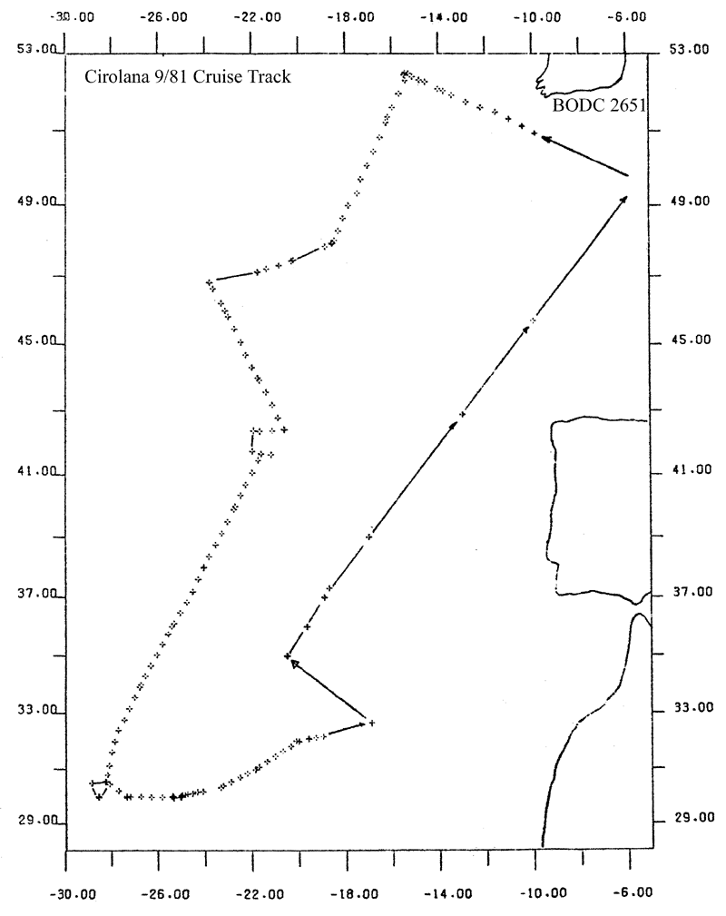
- References - including cruise tracks and cruise reports
Cruise Inventory Information
| Long name | RV Cirolana (74CZ) cruise CIR9/81 |
|---|---|
| Short name | CIR9/81 |
| Objectives and Narrative |
The objectives of this cruise were as follows:
(1) To deploy two upper-bottom moorings at the offshore end of a line along 52.5N down the continental slope west of Ireland. Accomplished. (2) To recover NEADS 5. (3) To recover and re-lay four upper-bottom moorings deployed by CIR06/81 east of the mid-Atlantic Ridge. Accomplished. (4) To lay six moorings across the Madeira Abyssal Plain at 30 N. Accomplshed. (5) Deploy abyssal fish traps. Accomplished. Catch included Coryphanoides and amphipods. (6) Recover moorings deployed by CIR9/80 in the King's Trough area. Three of four moorings recovered. (7) Collect large-volume water samples for radiochemical analysis. Accomplished. (8) CTD profiling and nutrient sampling. Accomplished. (9) Regular deployment of XBTs across appropriate parts of the cruise track. Accomplished. (10) Investigate CTD lowering rate on conductivity measurements in near-surface water. Accomplished. (11) Take box, boomerang and gravity cores accompanied by near-bed water samples. Accomplished. (12) Collect surface water samples for neodymium analysis. Accomplished. (13) Run an on-line HIAC particle sampler section across the continental slope. Accomplished. |
| Ship | RV Cirolana |
| Departure Port | Grimsby, United Kingdom |
| Departure Date | 1981-10-08 |
| Arrival Port | Grimsby, United Kingdom |
| Arrival Date | 1981-11-11 |
| Principal Scientist(s) | Paul A Gurbutt (Ministry of Agriculture, Fisheries and Food Lowestoft Fisheries Laboratory) |
| Responsible Organisation | Ministry of Agriculture, Fisheries and Food Lowestoft Fisheries Laboratory |
| Associated Project(s) | |
| IHB Sea Areas Visited | North East Atlantic Ocean (limit 40W) |
| Marsden Squares Visited | 110;2/111;1/111;2/111;3/111;4/146/147/182;1/75;3/75;4 |
| Work Area Description | N.E. Atlantic |
| Unable to lookup cruise bounds at this time | |
| Work Area Bounding Polygon | |
| Southern Limit | unknown |
| Northern Limit | unknown |
| Western Limit | unknown |
| Eastern Limit | unknown |
Cruise Inventory Datasets
| Physical oceanography | |
|---|---|
| Bathythermograph |
Quantity:
number of profiles =
96
Description: |
| CTD stations |
Quantity:
number of stations =
11
Description: |
| Current meters |
Quantity:
number of deployments =
19
Description: 170 days |
| Surface measurements underway (T,S) | Description: T only |
| Water bottle stations |
Quantity:
number of stations =
5
Description: |
| Chemical oceanography | |
| Other chemical oceanographic measurements |
Quantity:
number of samples =
12
Description: neodymium analysis(surface water) |
| Radioactivity |
Quantity:
number of samples =
8
Description: |
| Biology and fisheries | |
| Other biological/fisheries measurement |
Quantity:
number of samples =
3
Description: |
| Geology and geophysics | |
| Core - soft bottom |
Quantity:
number of cores =
10
Description: |
Cruise Inventory Mooring/Buoy Operations
No information on datasets is currently available
Summary of BODC Data Holdings for the Cruise
National Oceanographic Database
Summary
| # Series | Instrument Description | Parameters |
|---|---|---|
| 8 | CTD/STD cast |
Salinity of the water column Temperature of the water column Vertical spatial coordinates |
Note: Parameter terms are taken from the BODC Parameter Discovery Vocabulary XML (SKOS)
Full List
| BODC Reference | Instrument Description | Date/Time | Location | |
|---|---|---|---|---|
| 326269 | CTD/STD cast | 1981-10-22 20:31Z | 30° 0' N, 25° 19' W | Click for more |
| 326270 | CTD/STD cast | 1981-10-23 04:05Z | 29° 59' N, 25° 0' W | Click for more |
| 326282 | CTD/STD cast | 1981-10-23 23:54Z | 30° 1' N, 25° 0' W | Click for more |
| 326294 | CTD/STD cast | 1981-10-28 13:21Z | 32° 4' N, 19° 34' W | Click for more |
| 326301 | CTD/STD cast | 1981-11-02 05:12Z | 35° 0' N, 20° 30' W | Click for more |
| 326313 | CTD/STD cast | 1981-11-03 00:18Z | 36° 0' N, 19° 38' W | Click for more |
| 326325 | CTD/STD cast | 1981-11-04 02:43Z | 36° 59' N, 18° 52' W | Click for more |
| 326337 | CTD/STD cast | 1981-11-05 04:21Z | 39° 0' N, 16° 59' W | Click for more |
Project Database
No data currently held for this cruise in the BODC Project Database
