BODC Cruise Metadata Report for RRS Charles Darwin (74AB) cruise CD1
Introduction
This report collates information from the BODC cruise inventory and oceanographic databases. It presents
- Cruise Inventory Information
- A summary of BODC data holdings for the cruise from the
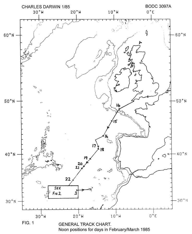
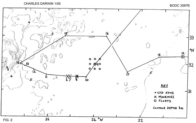
- References - including cruise tracks and cruise reports
Cruise Inventory Information
| Long name | RRS Charles Darwin (74AB) cruise CD1 |
|---|---|
| Short name | CD1 |
| Objectives and Narrative |
1) Recovery of the ARIES inverted echo sounder in the SW approaches.
2) Deployment of a near surface current buoy at the same location. 3) Deployment of four SOFAR floats near 41deg 30'N 14deg 30'W. 4) Working a line of CTD stations across the east Azores Fracture Zone. 5) Recovery of three current meter moorings at GME (31deg 30'N 25deg 00'W). 6) Deployment of replacement moorings at GME. 7) Deployment of a deepsea tide gauge in GME area. 8) Working of CTD stations in GME area and around the Madeira abyssal plain. |
| Ship | RRS Charles Darwin |
| Departure Port | Falmouth, United Kingdom |
| Departure Date | 1985-02-13 |
| Arrival Port | Funchal, Portugal |
| Arrival Date | 1985-03-04 |
| Principal Scientist(s) | W John Gould (Institute of Oceanographic Sciences Wormley Laboratory) |
| Responsible Organisation | Institute of Oceanographic Sciences Wormley Laboratory |
| Associated Project(s) | Physical Oceanography studies to study dispersion in the deep ocean |
| IHB Sea Areas Visited | North East Atlantic Ocean (limit 40W) |
| Marsden Squares Visited | 111;1/111;2/111;3/146;2/146;3 |
| Work Area Description | N.E. Atlantic |
| Unable to lookup cruise bounds at this time | |
| Work Area Bounding Polygon | |
| Southern Limit | unknown |
| Northern Limit | unknown |
| Western Limit | unknown |
| Eastern Limit | unknown |
Cruise Inventory Datasets
| Physical oceanography | |
|---|---|
| CTD stations |
Quantity:
number of profiles =
19
Description: |
| Current meters |
Quantity:
number of stations =
3
Description: moorings recovered, each with 3 current meters, located nominally 10, 100 & 1000 m above the sea bed. Durations 1 year. Moorings replaced. |
| Neutrally buoyant floats |
Quantity:
number of deployments =
16
Description: |
| Other physical oceanographic measurements |
Quantity:
number of deployments =
1
Description: autonomous listening station |
| Sea level (inc. bot. press., inverted echosounder) | Description: tide gauge deployed for recovery in spring 1986 and ARIES inverted echo sounder |
| Subsurface temperature and salinity measurements | Description: thermistors on current meters T only |
| Surface drifters/drifting buoys |
Quantity:
number of deployments =
1
Description: Collar buoy (float) |
| Water bottle stations | Description: water bottles for calibrating CTD bottom only |
| Meteorology | |
| Routine standard measurements | Description: synoptic hours |
| Geology and geophysics | |
| Multi-beam echosounding | Description: continous |
Cruise Inventory Mooring/Buoy Operations
No information on datasets is currently available
Summary of BODC Data Holdings for the Cruise
National Oceanographic Database
Summary
| # Series | Instrument Description | Parameters |
|---|---|---|
| 19 | CTD/STD cast |
Dissolved oxygen parameters in the water column Salinity of the water column Temperature of the water column Transmittance and attenuance of the water column Vertical spatial coordinates |
Note: Parameter terms are taken from the BODC Parameter Discovery Vocabulary XML (SKOS)
Full List
| BODC Reference | Instrument Description | Date/Time | Location | |
|---|---|---|---|---|
| 56981 | CTD/STD cast | 1985-02-15 17:22Z | 46° 13' N, 10° 48' W | Click for more |
| 56993 | CTD/STD cast | 1985-02-20 10:20Z | 37° 37' N, 18° 52' W | Click for more |
| 57007 | CTD/STD cast | 1985-02-20 20:52Z | 37° 28' N, 18° 50' W | Click for more |
| 57019 | CTD/STD cast | 1985-02-21 02:31Z | 37° 12' N, 18° 48' W | Click for more |
| 57020 | CTD/STD cast | 1985-02-21 15:14Z | 36° 58' N, 18° 53' W | Click for more |
| 57032 | CTD/STD cast | 1985-02-23 19:18Z | 31° 30' N, 25° 9' W | Click for more |
| 57044 | CTD/STD cast | 1985-02-24 00:20Z | 31° 30' N, 25° 3' W | Click for more |
| 57056 | CTD/STD cast | 1985-02-24 22:39Z | 31° 28' N, 24° 45' W | Click for more |
| 57068 | CTD/STD cast | 1985-02-25 07:52Z | 31° 58' N, 24° 0' W | Click for more |
| 57081 | CTD/STD cast | 1985-02-26 06:11Z | 31° 29' N, 24° 21' W | Click for more |
| 57093 | CTD/STD cast | 1985-02-27 15:18Z | 31° 33' N, 26° 7' W | Click for more |
| 57100 | CTD/STD cast | 1985-02-27 22:12Z | 31° 46' N, 26° 37' W | Click for more |
| 57112 | CTD/STD cast | 1985-02-28 11:43Z | 31° 55' N, 27° 0' W | Click for more |
| 57124 | CTD/STD cast | 1985-02-28 16:35Z | 32° 0' N, 27° 10' W | Click for more |
| 57136 | CTD/STD cast | 1985-03-01 08:12Z | 32° 59' N, 25° 15' W | Click for more |
| 57148 | CTD/STD cast | 1985-03-01 22:20Z | 33° 0' N, 23° 29' W | Click for more |
| 57161 | CTD/STD cast | 1985-03-02 11:29Z | 31° 40' N, 22° 34' W | Click for more |
| 57173 | CTD/STD cast | 1985-03-03 00:11Z | 32° 15' N, 21° 14' W | Click for more |
| 57185 | CTD/STD cast | 1985-03-03 10:24Z | 32° 20' N, 20° 15' W | Click for more |
Project Database
No data currently held for this cruise in the BODC Project Database
