BODC Cruise Metadata Report for RRS Charles Darwin (74AB) cruise CD9A
Introduction
This report collates information from the BODC cruise inventory and oceanographic databases. It presents
- Cruise Inventory Information
- A summary of BODC data holdings for the cruise from the
- References - including cruise tracks and cruise reports
Cruise Inventory Information
| Long name | RRS Charles Darwin (74AB) cruise CD9A |
|---|---|
| Short name | CD9A |
| Objectives and Narrative | Physical oceanography including moored current meters and acoustic listening stations (~30-45 degN, 13-26 degW) |
| Ship | RRS Charles Darwin |
| Departure Port | Funchal, Portugal |
| Departure Date | 1985-11-16 |
| Arrival Port | Lisbon, Portugal |
| Arrival Date | 1985-11-28 |
| Principal Scientist(s) | W John Gould (Institute of Oceanographic Sciences Wormley Laboratory) |
| Responsible Organisation | Institute of Oceanographic Sciences Wormley Laboratory |
| Associated Project(s) | sofar floats |
| IHB Sea Areas Visited | North East Atlantic Ocean (limit 40W) |
| Marsden Squares Visited | 110;1/110;2/110;384/110;394/110;469/110;478/111;1/111;215/111;350/111;4/146;113/146;228/146;229/146;3/146;4 |
| Work Area Description | |
| Unable to lookup cruise bounds at this time | |
| Work Area Bounding Polygon | |
| Southern Limit | unknown |
| Northern Limit | unknown |
| Western Limit | unknown |
| Eastern Limit | unknown |
Cruise Inventory Datasets
| Physical oceanography | |
|---|---|
| Bathythermograph |
Quantity:
number of profiles =
7
Description: |
| CTD stations |
Quantity:
number of profiles =
8
Description: |
| Current meters |
Quantity:
number of recoveries =
3
Description: 12 c.m. deployed;3 recovered;1 year |
| Other physical oceanographic measurements |
Quantity:
number of stations =
3
Description: ALS-3 recovered, 3 deployed |
| Water bottle stations | Description: water bottles as calibrations for CTD bottom only |
| Meteorology | |
| Routine standard measurements | Description: synoptic hours. |
| Geology and geophysics | |
| Bottom photography |
Quantity:
number of deployments =
1
Description: Bathysnap-bottom photograph+recording current meter |
| Multi-beam echosounding | Description: continous |
Cruise Inventory Mooring/Buoy Operations
No information on datasets is currently available
Summary of BODC Data Holdings for the Cruise
National Oceanographic Database
Summary
| # Series | Instrument Description | Parameters |
|---|---|---|
| 8 | CTD/STD cast |
Dissolved oxygen parameters in the water column Salinity of the water column Temperature of the water column Vertical spatial coordinates |
Note: Parameter terms are taken from the BODC Parameter Discovery Vocabulary XML (SKOS)
Full List
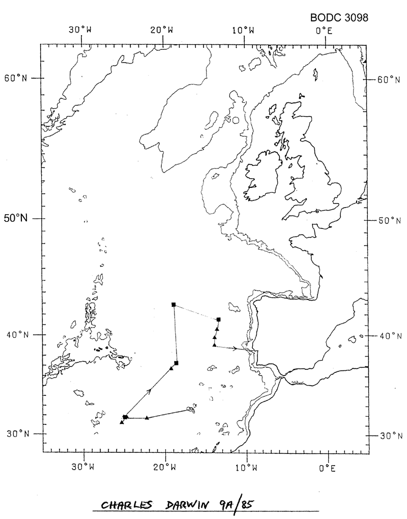
| BODC Reference | Instrument Description | Date/Time | Location | |
|---|---|---|---|---|
| 57289 | CTD/STD cast | 1985-11-17 13:48Z | 31° 39' N, 22° 33' W | Click for more |
| 57290 | CTD/STD cast | 1985-11-18 23:45Z | 31° 30' N, 25° 10' W | Click for more |
| 57308 | CTD/STD cast | 1985-11-19 06:30Z | 31° 15' N, 25° 25' W | Click for more |
| 57321 | CTD/STD cast | 1985-11-20 04:41Z | 31° 34' N, 24° 42' W | Click for more |
| 57333 | CTD/STD cast | 1985-11-22 00:08Z | 36° 43' N, 19° 15' W | Click for more |
| 57345 | CTD/STD cast | 1985-11-26 07:17Z | 40° 26' N, 13° 48' W | Click for more |
| 57357 | CTD/STD cast | 1985-11-26 19:46Z | 39° 30' N, 14° 1' W | Click for more |
| 57369 | CTD/STD cast | 1985-11-27 03:04Z | 38° 58' N, 14° 0' W | Click for more |
Project Database
No data currently held for this cruise in the BODC Project Database
