BODC Cruise Metadata Report for RRS Challenger (74CH) cruise CH10
Introduction
This report collates information from the BODC cruise inventory and oceanographic databases. It presents
- Cruise Inventory Information
- A summary of BODC data holdings for the cruise from the
- References - including cruise tracks and cruise reports
Cruise Inventory Information
| Long name | RRS Challenger (74CH) cruise CH10 |
|---|---|
| Short name | CH10 |
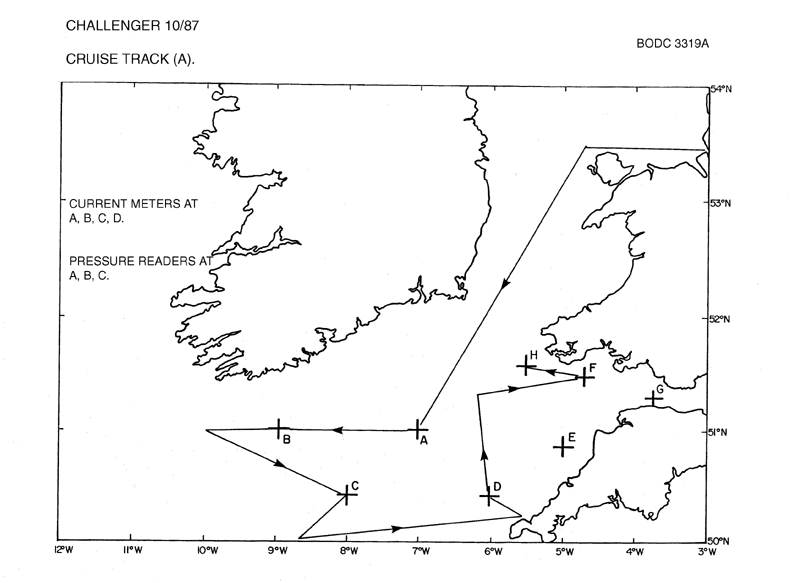
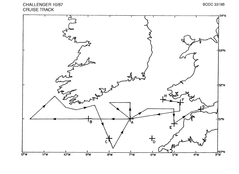
| Objectives and Narrative | To obtain measurements of the vertical variation of current with depth in an area of weak tidal currents during will mixed conditions. To obtain the necessary supporting measurements (winds, waves, density field, gradients of currents and pressures) to interpret these current profile measurements. |
| Ship | RRS Challenger |
| Departure Port | Birkenhead, United Kingdom |
| Departure Date | 1987-01-27 |
| Arrival Port | Barry, United Kingdom |
| Arrival Date | 1987-02-07 |
| Principal Scientist(s) | M John Howarth (Institute of Oceanographic Sciences Bidston Laboratory) |
| Responsible Organisation | Institute of Oceanographic Sciences Bidston Laboratory |
| Associated Project(s) | |
| IHB Sea Areas Visited | Bristol Channel, Celtic Sea, North East Atlantic Ocean (limit 40W) |
| Marsden Squares Visited | 181;104/181;113/181;114/181;205/181;206/181;207/181;208/181;209/181;219/182;110/182;111 |
| Work Area Description | Bristol Channel and Celtic Sea |
| Unable to lookup cruise bounds at this time | |
| Work Area Bounding Polygon | |
| Southern Limit | unknown |
| Northern Limit | unknown |
| Western Limit | unknown |
| Eastern Limit | unknown |
Cruise Inventory Datasets
| Physical oceanography | |
|---|---|
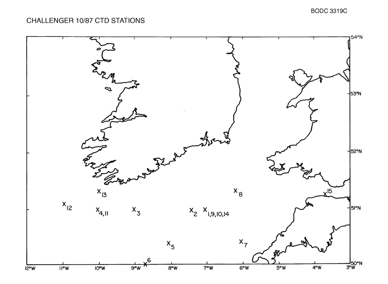
| CTD stations |
Quantity:
number of stations =
15
Description: |
| Current meters |
Quantity:
number of deployments =
18
Description: deployed,to be recovered on cr.12/87,also tide guages |
| Current profiler (eg ADCP) | Description: acoustic doppler,profiling c-m |
| Sea level (inc. bot. press., inverted echosounder) |
Quantity:
number of deployments =
3
Description: |
| Surface measurements underway (T,S) | Description: |
Cruise Inventory Mooring/Buoy Operations
No information on datasets is currently available
Summary of BODC Data Holdings for the Cruise
National Oceanographic Database
Summary
| # Series | Instrument Description | Parameters |
|---|---|---|
| 14 | CTD/STD cast |
Salinity of the water column Temperature of the water column Vertical spatial coordinates |
Note: Parameter terms are taken from the BODC Parameter Discovery Vocabulary XML (SKOS)
Full List
| BODC Reference | Instrument Description | Date/Time | Location | |
|---|---|---|---|---|
| 59211 | CTD/STD cast | 1987-01-29 20:46Z to 1987-01-29 21:00Z | 50° 59' N, 7° 0' W | Click for more |
| 59223 | CTD/STD cast | 1987-01-30 14:07Z to 1987-01-30 14:23Z | 50° 59' N, 8° 59' W | Click for more |
| 59235 | CTD/STD cast | 1987-01-30 20:05Z to 1987-01-30 20:17Z | 51° 0' N, 10° 0' W | Click for more |
| 59247 | CTD/STD cast | 1987-01-31 10:54Z to 1987-01-31 11:06Z | 50° 24' N, 8° 0' W | Click for more |
| 59259 | CTD/STD cast | 1987-01-31 14:53Z to 1987-01-31 15:07Z | 50° 0' N, 8° 40' W | Click for more |
| 59260 | CTD/STD cast | 1987-02-01 10:35Z to 1987-02-01 10:45Z | 50° 24' N, 6° 1' W | Click for more |
| 59272 | CTD/STD cast | 1987-02-01 18:06Z to 1987-02-01 18:08Z | 51° 19' N, 6° 10' W | Click for more |
| 59284 | CTD/STD cast | 1987-02-03 11:25Z to 1987-02-03 11:34Z | 51° 0' N, 6° 58' W | Click for more |
| 59296 | CTD/STD cast | 1987-02-04 13:01Z to 1987-02-04 13:10Z | 51° 0' N, 7° 1' W | Click for more |
| 59303 | CTD/STD cast | 1987-02-05 16:05Z to 1987-02-05 16:18Z | 50° 59' N, 10° 0' W | Click for more |
| 59315 | CTD/STD cast | 1987-02-05 22:04Z to 1987-02-05 22:08Z | 51° 2' N, 10° 57' W | Click for more |
| 59327 | CTD/STD cast | 1987-02-06 11:12Z to 1987-02-06 11:22Z | 51° 19' N, 9° 58' W | Click for more |
| 59339 | CTD/STD cast | 1987-02-07 10:25Z to 1987-02-07 10:35Z | 51° 0' N, 6° 58' W | Click for more |
| 59340 | CTD/STD cast | 1987-02-08 15:47Z to 1987-02-08 15:49Z | 51° 18' N, 3° 39' W | Click for more |
Project Database
No data currently held for this cruise in the BODC Project Database
