BODC Cruise Metadata Report for RRS Discovery (74E3) cruise D189
Introduction
This report collates information from the BODC cruise inventory and oceanographic databases. It presents
- Cruise Inventory Information
- A summary of BODC data holdings for the cruise from the
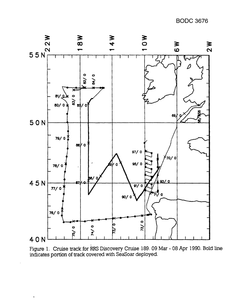
- References - including cruise tracks and cruise reports
Cruise Inventory Information
| Long name | RRS Discovery (74E3) cruise D189 |
|---|---|
| Short name | D189 |
| Objectives and Narrative |
1. Study and quantify the circulation of the region of the Atlantic north and east of 42N, 20W and south of 53N, with a box of full-depth CTD casts; sampling to include CTDO measurements together with fluorescence and transmittance profiles, and salinity, oxygen and nutrients from Niskin bottles. The pattern of CTD and SeaSoar measurements to closely follow the track of Cruise 181, 12 months earlier.
2. Continue a programme of SeaSoar development by means of trial deployments involving a package of sensors mounted on the towed vehicle. 3. Survey the interior of the box of CTD stations using SeaSoar, to quantify the T/S characteristics of recently-ventilated Mode water. 4. Make underway ADCP measurements throughout the cruise. 5. Make underway analysis of non-toxic pumped seawater supply using thermosalinograph and fluorometer. 6. Occupy a grid of CTD stations in the Bay of Biscay east of 10W, as part of the GASTOM experiment. 7. Test a modification to a piece of coring equipment for IOSDL.. |
| Ship | RRS Discovery |
| Departure Port | Cardiff, United Kingdom |
| Departure Date | 1990-03-09 |
| Arrival Port | Barry, United Kingdom |
| Arrival Date | 1990-04-08 |
| Principal Scientist(s) | Brian A King (Institute of Oceanographic Sciences Deacon Laboratory) |
| Responsible Organisation | Institute of Oceanographic Sciences Deacon Laboratory |
| Associated Project(s) | GASTOM |
| IHB Sea Areas Visited | North East Atlantic Ocean (limit 40W) |
| Marsden Squares Visited | 145/146/182 |
| Work Area Description | Eastern Atlantic Ocean |
| Unable to lookup cruise bounds at this time | |
| Work Area Bounding Polygon | |
| Southern Limit | unknown |
| Northern Limit | unknown |
| Western Limit | unknown |
| Eastern Limit | unknown |
Cruise Inventory Datasets
| Physical oceanography | |
|---|---|
| Bathythermograph |
Quantity:
number of profiles =
53
Description: |
| CTD stations |
Quantity:
number of profiles =
59
Description: |
| Subsurface temperature and salinity measurements |
Quantity:
track kilometres =
2500
Description: Underway profiling CTD (SeaSoar) |
| Surface measurements underway (T,S) |
Quantity:
track kilometres =
8000
Description: underway thermosalinograph |
| Transparency (eg transmissometer) |
Quantity:
number of profiles =
59
Description: Transmissometer attached to CTD |
| Water bottle stations |
Quantity:
number of profiles =
59
Description: |
| Chemical oceanography | |
| Nitrate |
Quantity:
number of profiles =
59
Description: |
| Oxygen |
Quantity:
number of profiles =
59
Description: |
| Oxygen |
Quantity:
number of profiles =
59
Description: Oxygen sensor attached to CTD |
| Phosphate |
Quantity:
number of profiles =
59
Description: |
| Silicate |
Quantity:
number of profiles =
59
Description: |
| Biology and fisheries | |
| Phytoplankton pigs (eg chlorophyll, fluorescence) |
Quantity:
track kilometres =
2500
Description: Fluorometer attached to SeaSoar |
| Phytoplankton pigs (eg chlorophyll, fluorescence) |
Quantity:
track kilometres =
8000
Description: underway fluorometer |
| Phytoplankton pigs (eg chlorophyll, fluorescence) |
Quantity:
number of profiles =
59
Description: Fluorometer attached to CTD |
| Meteorology | |
| Routine standard measurements |
Quantity:
activity duration in days =
30
Description: |
| Geology and geophysics | |
| Single-beam echosounding |
Quantity:
track kilometres =
8000
Description: wide beam bathymetry, 10KHz PES |
Cruise Inventory Mooring/Buoy Operations
No information on datasets is currently available
Summary of BODC Data Holdings for the Cruise
National Oceanographic Database
Summary
| # Series | Instrument Description | Parameters |
|---|---|---|
| 4 | CTD in towed or autonomous underwater vehicle |
Horizontal platform movement Horizontal spatial co-ordinates Reference numbers Salinity of the water column Temperature of the water column Vertical spatial coordinates |
| 1 | CTD/STD cast |
Dissolved oxygen parameters in the water column Salinity of the water column Temperature of the water column Transmittance and attenuance of the water column Vertical spatial coordinates |
| 58 | CTD/STD cast |
Chlorophyll pigment concentrations in water bodies Dissolved oxygen parameters in the water column Salinity of the water column Temperature of the water column Transmittance and attenuance of the water column Vertical spatial coordinates |
Note: Parameter terms are taken from the BODC Parameter Discovery Vocabulary XML (SKOS)
Full List
| BODC Reference | Instrument Description | Date/Time | Location | |
|---|---|---|---|---|
| 436321 | CTD/STD cast | 1990-03-12 10:23Z | 42° 15' N, 9° 13' W | Click for more |
| 436333 | CTD/STD cast | 1990-03-12 12:16Z | 42° 15' N, 9° 28' W | Click for more |
| 436345 | CTD/STD cast | 1990-03-12 14:34Z | 42° 14' N, 9° 32' W | Click for more |
| 436357 | CTD/STD cast | 1990-03-12 17:04Z | 42° 13' N, 9° 40' W | Click for more |
| 436369 | CTD/STD cast | 1990-03-12 21:59Z | 42° 9' N, 10° 19' W | Click for more |
| 436370 | CTD/STD cast | 1990-03-13 04:23Z | 42° 6' N, 11° 13' W | Click for more |
| 436382 | CTD/STD cast | 1990-03-13 10:43Z | 42° 2' N, 12° 7' W | Click for more |
| 436394 | CTD/STD cast | 1990-03-13 17:10Z | 41° 57' N, 12° 59' W | Click for more |
| 436401 | CTD/STD cast | 1990-03-14 01:12Z | 41° 54' N, 13° 57' W | Click for more |
| 436413 | CTD/STD cast | 1990-03-14 08:25Z | 41° 51' N, 14° 46' W | Click for more |
| 436425 | CTD/STD cast | 1990-03-14 17:25Z | 41° 48' N, 15° 40' W | Click for more |
| 436437 | CTD/STD cast | 1990-03-15 00:44Z | 41° 43' N, 16° 33' W | Click for more |
| 436449 | CTD/STD cast | 1990-03-15 08:20Z | 41° 39' N, 17° 26' W | Click for more |
| 436450 | CTD/STD cast | 1990-03-15 18:25Z | 41° 40' N, 18° 23' W | Click for more |
| 436462 | CTD/STD cast | 1990-03-16 02:32Z | 41° 34' N, 19° 13' W | Click for more |
| 436474 | CTD/STD cast | 1990-03-16 10:19Z | 41° 34' N, 20° 3' W | Click for more |
| 436486 | CTD/STD cast | 1990-03-16 18:54Z | 42° 10' N, 20° 17' W | Click for more |
| 436498 | CTD/STD cast | 1990-03-17 01:52Z | 42° 48' N, 20° 14' W | Click for more |
| 436505 | CTD/STD cast | 1990-03-17 09:57Z | 43° 26' N, 20° 9' W | Click for more |
| 436517 | CTD/STD cast | 1990-03-17 16:19Z | 44° 3' N, 20° 2' W | Click for more |
| 436529 | CTD/STD cast | 1990-03-17 22:52Z | 44° 42' N, 20° 0' W | Click for more |
| 436530 | CTD/STD cast | 1990-03-18 05:11Z | 45° 19' N, 19° 57' W | Click for more |
| 436542 | CTD/STD cast | 1990-03-18 14:11Z | 45° 58' N, 19° 53' W | Click for more |
| 436554 | CTD/STD cast | 1990-03-18 20:34Z | 46° 36' N, 19° 47' W | Click for more |
| 436566 | CTD/STD cast | 1990-03-19 03:37Z | 47° 14' N, 19° 42' W | Click for more |
| 436578 | CTD/STD cast | 1990-03-19 10:39Z | 47° 54' N, 19° 34' W | Click for more |
| 436591 | CTD/STD cast | 1990-03-19 20:01Z | 48° 38' N, 19° 31' W | Click for more |
| 436609 | CTD/STD cast | 1990-03-20 02:47Z | 49° 19' N, 19° 31' W | Click for more |
| 436610 | CTD/STD cast | 1990-03-20 10:05Z | 50° 1' N, 19° 36' W | Click for more |
| 436622 | CTD/STD cast | 1990-03-20 16:31Z | 50° 41' N, 19° 36' W | Click for more |
| 436634 | CTD/STD cast | 1990-03-20 23:59Z | 51° 19' N, 19° 33' W | Click for more |
| 436646 | CTD/STD cast | 1990-03-21 22:23Z | 52° 1' N, 19° 34' W | Click for more |
| 436658 | CTD/STD cast | 1990-03-22 11:16Z | 52° 40' N, 19° 33' W | Click for more |
| 436671 | CTD/STD cast | 1990-03-22 17:10Z | 52° 39' N, 18° 29' W | Click for more |
| 436683 | CTD/STD cast | 1990-03-24 17:29Z | 52° 40' N, 17° 24' W | Click for more |
| 436695 | CTD/STD cast | 1990-03-25 00:33Z | 52° 39' N, 16° 17' W | Click for more |
| 436702 | CTD/STD cast | 1990-03-25 06:17Z | 52° 40' N, 15° 27' W | Click for more |
| 436714 | CTD/STD cast | 1990-03-25 09:19Z | 52° 40' N, 15° 13' W | Click for more |
| 436726 | CTD/STD cast | 1990-03-25 11:43Z | 52° 39' N, 15° 2' W | Click for more |
| 436738 | CTD/STD cast | 1990-04-01 16:52Z | 46° 22' N, 8° 25' W | Click for more |
| 436751 | CTD/STD cast | 1990-04-01 23:43Z | 47° 2' N, 8° 25' W | Click for more |
| 436763 | CTD/STD cast | 1990-04-02 17:46Z | 45° 41' N, 8° 25' W | Click for more |
| 436775 | CTD/STD cast | 1990-04-03 00:41Z | 45° 1' N, 8° 24' W | Click for more |
| 436787 | CTD/STD cast | 1990-04-03 07:25Z | 44° 22' N, 8° 24' W | Click for more |
| 436799 | CTD/STD cast | 1990-04-03 10:39Z | 44° 15' N, 8° 25' W | Click for more |
| 436806 | CTD/STD cast | 1990-04-03 14:33Z | 44° 11' N, 9° 2' W | Click for more |
| 436818 | CTD/STD cast | 1990-04-03 16:15Z | 44° 12' N, 9° 10' W | Click for more |
| 436831 | CTD/STD cast | 1990-04-03 20:52Z | 44° 21' N, 9° 55' W | Click for more |
| 436843 | CTD/STD cast | 1990-04-04 06:43Z | 44° 53' N, 9° 9' W | Click for more |
| 436855 | CTD/STD cast | 1990-04-04 12:29Z | 45° 1' N, 9° 55' W | Click for more |
| 436867 | CTD/STD cast | 1990-04-04 22:41Z | 45° 32' N, 9° 9' W | Click for more |
| 436879 | CTD/STD cast | 1990-04-05 04:50Z | 45° 42' N, 9° 55' W | Click for more |
| 436880 | CTD/STD cast | 1990-04-05 13:51Z | 46° 12' N, 9° 10' W | Click for more |
| 436892 | CTD/STD cast | 1990-04-05 19:53Z | 46° 22' N, 9° 54' W | Click for more |
| 436911 | CTD/STD cast | 1990-04-06 04:25Z | 46° 51' N, 9° 10' W | Click for more |
| 436923 | CTD/STD cast | 1990-04-06 10:21Z | 47° 2' N, 9° 54' W | Click for more |
| 436935 | CTD/STD cast | 1990-04-06 19:59Z | 47° 32' N, 9° 10' W | Click for more |
| 436947 | CTD/STD cast | 1990-04-07 00:30Z | 47° 42' N, 9° 55' W | Click for more |
| 436959 | CTD/STD cast | 1990-04-07 07:16Z | 48° 22' N, 10° 2' W | Click for more |
| 436960 | CTD in towed or autonomous underwater vehicle | 1990-03-31 04:13:00Z | From 43° 28' N, 11° 0' W to 47° 28' N, 8° 25' W | Click for more |
| 436972 | CTD in towed or autonomous underwater vehicle | 1990-03-29 17:42:00Z | From 47° 30' N, 13° 29' W to 43° 28' N, 11° 0' W | Click for more |
| 436984 | CTD in towed or autonomous underwater vehicle | 1990-03-28 08:58:00Z | From 44° 1' N, 17° 0' W to 47° 30' N, 13° 29' W | Click for more |
| 436996 | CTD in towed or autonomous underwater vehicle | 1990-03-25 20:27:00Z | From 51° 52' N, 16° 30' W to 44° 1' N, 17° 0' W | Click for more |
Project Database
No data currently held for this cruise in the BODC Project Database
