BODC Cruise Metadata Report for RV Cirolana (74CZ) cruise CIR6/94
Introduction
This report collates information from the BODC cruise inventory and oceanographic databases. It presents
- Cruise Inventory Information
- A summary of BODC data holdings for the cruise from the
- References - including cruise tracks and cruise reports
Cruise Inventory Information
| Long name | RV Cirolana (74CZ) cruise CIR6/94 |
|---|---|
| Short name | CIR6/94 |
| Objectives and Narrative |
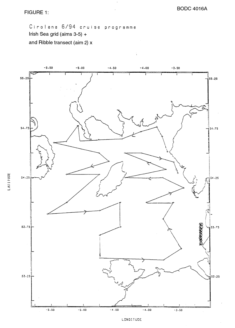
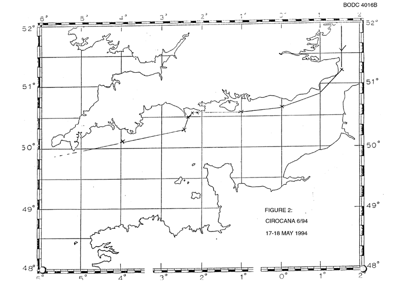
1. To study the surface sediment and water concentrations of U, Th, Ra, Po and Pb radionuclides and nutrients in the immediate vicinity of the Marchon outfall and further offshore in the eastern Irish Sea. Part of this work is to be carried out in conjunction with a small charter vessel (AE0115A).
2. To commence a study to investigate the surface sediment and water concentrations of radionuclides from the Ribble estuary (AE0115A). 3. Collection of sediment cores from the Irish Sea and thus enable laboratory experiments to be carried out to evaluate the relative importance of historic and current discharges of radionuclides to the sea from Sellafield (AE0117A). 4. To collect and process surface water from the Irish Sea for the analysis Tc, Cs, Sb and transuranic radionuclides as part of the Post EARP survey (AE0114A, Nuclear Fission Safety Programme - CEC contract). 5. To collect plankton samples and hence study, in conjunction with aim 4, concentration processes of radionuclides in the primary food chain (AE0117A, Nuclear Fission Safety Programme). 6. Collection of live Plaice from Rye Bay and thus enable laboratory experiments to be carried out to evaluate radiation effects on reproduction (AE0116A). 7. To collect, on behalf of IAEA, a bulk fish sample for world wide distribution as a intercalibration reference sample. All of the aims were successfully completed |
| Ship | RV Cirolana |
| Departure Port | Lowestoft, United Kingdom |
| Departure Date | 1994-05-17 |
| Arrival Port | Lowestoft, United Kingdom |
| Arrival Date | 1994-06-03 |
| Principal Scientist(s) | Kinson S Leonard (Ministry of Agriculture, Fisheries and Food Lowestoft Fisheries Laboratory) |
| Responsible Organisation | Ministry of Agriculture, Fisheries and Food Lowestoft Fisheries Laboratory |
| Associated Project(s) | Post EARP Survey |
| IHB Sea Areas Visited | English Channel, Irish Sea and St. George's Channel |
| Marsden Squares Visited | 181;1/181;2/216;1 |
| Work Area Description | Irish Sea |
| Unable to lookup cruise bounds at this time | |
| Work Area Bounding Polygon | |
| Southern Limit | unknown |
| Northern Limit | unknown |
| Western Limit | unknown |
| Eastern Limit | unknown |
Cruise Inventory Datasets
| Physical oceanography | |
|---|---|
| CTD stations |
Quantity:
number of stations =
9
Description: |
| Surface measurements underway (T,S) |
Quantity:
number of samples =
111
Description: surface salinity Marchon outfall and vicinity |
| Chemical oceanography | |
| Ammonia |
Quantity:
number of samples =
68
Description: surface |
| Nitrate |
Quantity:
number of samples =
68
Description: surface |
| Nitrite |
Quantity:
number of samples =
68
Description: surface |
| Phosphate |
Quantity:
number of samples =
68
Description: surface |
| Radioactivity |
Quantity:
number of samples =
171
Description: (Uranium, Thorium, Radium, Polonium, Lead radionuclies, Marchon & Ribble |
| Radioactivity | Description: Technetium, Caesium, Antimony, transuranic as part of post EARP |
| Silicate |
Quantity:
number of samples =
68
Description: surface |
| Biology and fisheries | |
| Demersal fish |
Quantity:
number of hauls =
19
Description: |
| Phytoplankton |
Quantity:
number of stations =
15
Description: |
| Zooplankton |
Quantity:
number of stations =
15
Description: |
| Geology and geophysics | |
| Core - soft bottom |
Quantity:
number of cores =
9
Description: historic/current discharges of radionuclides from Sellafield |
| Grab |
Quantity:
number of samples =
30
Description: surface sediment for transuranic elements |
Cruise Inventory Mooring/Buoy Operations
No information on datasets is currently available
Summary of BODC Data Holdings for the Cruise
National Oceanographic Database
Summary
| # Series | Instrument Description | Parameters |
|---|---|---|
| 10 | CTD/STD cast |
Concentration of suspended particulate material in the water column Reference numbers Salinity of the water column Temperature of the water column Transmittance and attenuance of the water column Vertical spatial coordinates |
Note: Parameter terms are taken from the BODC Parameter Discovery Vocabulary XML (SKOS)
Full List
| BODC Reference | Instrument Description | Date/Time | Location | |
|---|---|---|---|---|
| 488686 | CTD/STD cast | 1994-05-22 14:55Z | 53° 49' N, 3° 9' W | Click for more |
| 488698 | CTD/STD cast | 1994-05-23 09:18Z | 53° 43' N, 3° 10' W | Click for more |
| 488705 | CTD/STD cast | 1994-05-23 11:55Z | 53° 35' N, 3° 13' W | Click for more |
| 488717 | CTD/STD cast | 1994-05-23 12:33Z | 53° 37' N, 3° 13' W | Click for more |
| 488729 | CTD/STD cast | 1994-05-23 13:06Z | 53° 39' N, 3° 12' W | Click for more |
| 488730 | CTD/STD cast | 1994-05-23 13:39Z | 53° 40' N, 3° 11' W | Click for more |
| 488742 | CTD/STD cast | 1994-05-23 14:18Z | 53° 43' N, 3° 10' W | Click for more |
| 488754 | CTD/STD cast | 1994-05-23 14:54Z | 53° 45' N, 3° 10' W | Click for more |
| 488766 | CTD/STD cast | 1994-05-23 15:30Z | 53° 46' N, 3° 10' W | Click for more |
| 488778 | CTD/STD cast | 1994-05-23 16:44Z | 53° 49' N, 3° 9' W | Click for more |
Project Database
No data currently held for this cruise in the BODC Project Database
