BODC Cruise Metadata Report for FRV Scotia (748S) cruise 1298S
Introduction
This report collates information from the BODC cruise inventory and oceanographic databases. It presents
- Cruise Inventory Information
- A summary of BODC data holdings for the cruise from the
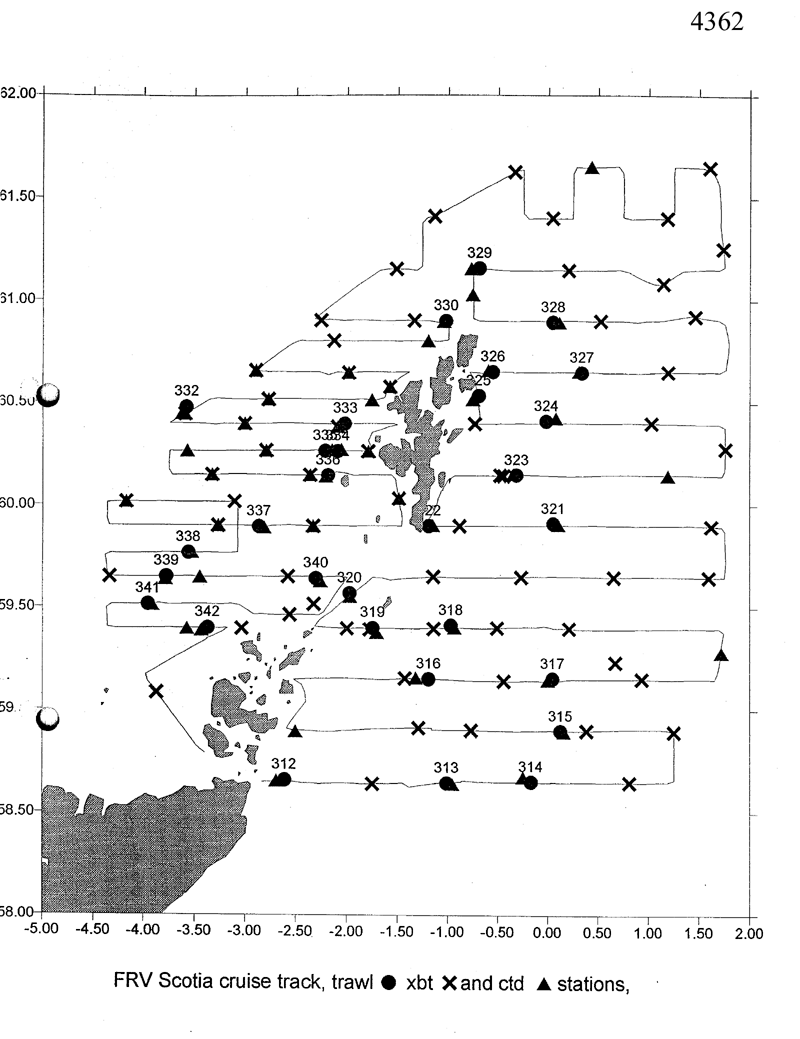
- References - including cruise tracks and cruise reports
Cruise Inventory Information
| Long name | FRV Scotia (748S) cruise 1298S |
|---|---|
| Short name | 1298S |
| Objectives and Narrative |
1. To participate in an ICES - coordinated acoustic and mid-water trawling survey in the north western North Sea and north of Scotland between 58ş 30 to 62şN and 4şW to 2şE excluding Norwegian and Faroes water.
2. To obtain samples of herring for biological analysis, including age, length, maturity and ichthyothonus infection rates. 3. To obtain thermosalinograph recordings throughout the survey, CTD profiles (and XBT profiles) and sea surface T&S for analysis of herring distribution, seabird distribution and the environment. 4. To obtain Methot net samples of plankton and micro nekton at night. 5. To obtain estimates of seabird density. |
| Ship | FRV Scotia |
| Departure Port | Aberdeen, United Kingdom |
| Departure Date | 1998-07-10 |
| Arrival Port | Aberdeen, United Kingdom |
| Arrival Date | 1998-07-27 |
| Principal Scientist(s) | Edmund John Simmonds (Fisheries Research Services Aberdeen Marine Laboratory) |
| Responsible Organisation | Fisheries Research Services Aberdeen Marine Laboratory |
| Associated Project(s) | |
| IHB Sea Areas Visited | North Sea, North East Atlantic Ocean (limit 40W) |
| Marsden Squares Visited | 181;4/217;1/217;2 |
| Work Area Description | NW North Sea and north of Scotland, North west Scotland and north of Scotland. |
| Unable to lookup cruise bounds at this time | |
| Work Area Bounding Polygon | |
| Southern Limit | unknown |
| Northern Limit | unknown |
| Western Limit | unknown |
| Eastern Limit | unknown |
Cruise Inventory Datasets
| Physical oceanography | |
|---|---|
| Bathythermograph |
Quantity:
number of profiles =
42
Description: XBT |
| CTD stations |
Quantity:
number of stations =
66
Description: CTD casts. |
| Subsurface temperature and salinity measurements |
Quantity:
activity duration in days =
17
Description: days thermosalinograph. |
| Biology and fisheries | |
| Acoustic reflection on marine organisms. |
Quantity:
number of measurements =
918
Description: 15 min. echo integrator runs. |
| Pelagic fish |
Quantity:
number of hauls =
31
Description: Herring and 3234 other fish |
| Zooplankton |
Quantity:
number of hauls =
30
Description: Methot net hauls for plankton. |
| Geology and geophysics | |
| Other geological/geophysical measurements |
Quantity:
activity duration in days =
15
Description: days RoxAnn measurements. |
Cruise Inventory Mooring/Buoy Operations
No information on datasets is currently available
Summary of BODC Data Holdings for the Cruise
National Oceanographic Database
Summary
| # Series | Instrument Description | Parameters |
|---|---|---|
| 39 | CTD/STD cast |
Electrical conductivity of the water column Reference numbers Salinity of the water column Temperature of the water column Vertical spatial coordinates |
Note: Parameter terms are taken from the BODC Parameter Discovery Vocabulary XML (SKOS)
Full List
| BODC Reference | Instrument Description | Date/Time | Location | |
|---|---|---|---|---|
| 514941 | CTD/STD cast | 1998-07-11 09:12Z | 58° 39' N, 2° 41' W | Click for more |
| 514953 | CTD/STD cast | 1998-07-11 16:33Z | 58° 38' N, 0° 57' W | Click for more |
| 514965 | CTD/STD cast | 1998-07-11 21:01Z | 58° 40' N, 0° 15' W | Click for more |
| 514977 | CTD/STD cast | 1998-07-12 12:44Z | 58° 54' N, 0° 9' E | Click for more |
| 514989 | CTD/STD cast | 1998-07-12 22:24Z | 58° 54' N, 2° 30' W | Click for more |
| 514990 | CTD/STD cast | 1998-07-13 09:45Z | 59° 9' N, 1° 19' W | Click for more |
| 515004 | CTD/STD cast | 1998-07-13 15:55Z | 59° 9' N, 0° 0' W | Click for more |
| 515016 | CTD/STD cast | 1998-07-13 22:15Z | 59° 16' N, 1° 43' W | Click for more |
| 515028 | CTD/STD cast | 1998-07-14 12:17Z | 59° 24' N, 0° 55' W | Click for more |
| 515041 | CTD/STD cast | 1998-07-14 21:43Z | 59° 33' N, 1° 58' W | Click for more |
| 515053 | CTD/STD cast | 1998-07-15 21:46Z | 59° 54' N, 0° 6' W | Click for more |
| 515065 | CTD/STD cast | 1998-07-16 06:56Z | 59° 54' N, 1° 9' W | Click for more |
| 515077 | CTD/STD cast | 1998-07-16 17:27Z | 60° 9' N, 0° 21' W | Click for more |
| 515089 | CTD/STD cast | 1998-07-16 22:12Z | 60° 9' N, 1° 11' E | Click for more |
| 515090 | CTD/STD cast | 1998-07-17 12:15Z | 60° 25' N, 0° 4' E | Click for more |
| 515108 | CTD/STD cast | 1998-07-17 17:39Z | 60° 31' N, 0° 42' W | Click for more |
| 515121 | CTD/STD cast | 1998-07-17 21:05Z | 60° 39' N, 0° 36' W | Click for more |
| 515133 | CTD/STD cast | 1998-07-18 05:37Z | 60° 39' N, 0° 18' E | Click for more |
| 515145 | CTD/STD cast | 1998-07-18 18:29Z | 60° 53' N, 0° 6' E | Click for more |
| 515157 | CTD/STD cast | 1998-07-18 22:08Z | 61° 1' N, 0° 45' W | Click for more |
| 515169 | CTD/STD cast | 1998-07-19 05:19Z | 61° 9' N, 0° 46' W | Click for more |
| 515170 | CTD/STD cast | 1998-07-19 22:12Z | 61° 39' N, 0° 25' E | Click for more |
| 515182 | CTD/STD cast | 1998-07-20 20:36Z | 60° 54' N, 1° 2' W | Click for more |
| 515194 | CTD/STD cast | 1998-07-20 22:12Z | 60° 48' N, 1° 12' W | Click for more |
| 515201 | CTD/STD cast | 1998-07-21 14:27Z | 60° 30' N, 1° 45' W | Click for more |
| 515213 | CTD/STD cast | 1998-07-21 22:27Z | 60° 27' N, 3° 37' W | Click for more |
| 515225 | CTD/STD cast | 1998-07-22 08:43Z | 60° 24' N, 2° 4' W | Click for more |
| 515237 | CTD/STD cast | 1998-07-22 14:34Z | 60° 16' N, 2° 3' W | Click for more |
| 515249 | CTD/STD cast | 1998-07-22 17:23Z | 60° 16' N, 2° 9' W | Click for more |
| 515250 | CTD/STD cast | 1998-07-22 22:16Z | 60° 16' N, 3° 34' W | Click for more |
| 515262 | CTD/STD cast | 1998-07-23 08:36Z | 60° 8' N, 2° 12' W | Click for more |
| 515274 | CTD/STD cast | 1998-07-23 22:33Z | 59° 53' N, 2° 49' W | Click for more |
| 515286 | CTD/STD cast | 1998-07-24 14:27Z | 59° 46' N, 3° 31' W | Click for more |
| 515298 | CTD/STD cast | 1998-07-24 20:52Z | 59° 38' N, 3° 47' W | Click for more |
| 515305 | CTD/STD cast | 1998-07-24 22:11Z | 59° 39' N, 3° 27' W | Click for more |
| 515317 | CTD/STD cast | 1998-07-25 07:47Z | 59° 37' N, 2° 15' W | Click for more |
| 515329 | CTD/STD cast | 1998-07-25 17:38Z | 59° 30' N, 3° 55' W | Click for more |
| 515330 | CTD/STD cast | 1998-07-25 22:08Z | 59° 24' N, 3° 34' W | Click for more |
| 515342 | CTD/STD cast | 1998-07-26 06:05Z | 59° 23' N, 3° 26' W | Click for more |
Project Database
No data currently held for this cruise in the BODC Project Database
