BODC Cruise Metadata Report for RRS John Murray cruise JM4/77
Introduction
This report collates information from the BODC cruise inventory and oceanographic databases. It presents
- Cruise Inventory Information
- A summary of BODC data holdings for the cruise from the
- References - including cruise tracks and cruise reports
Cruise Inventory Information
| Long name | RRS John Murray cruise JM4/77 |
|---|---|
| Short name | JM4/77 |
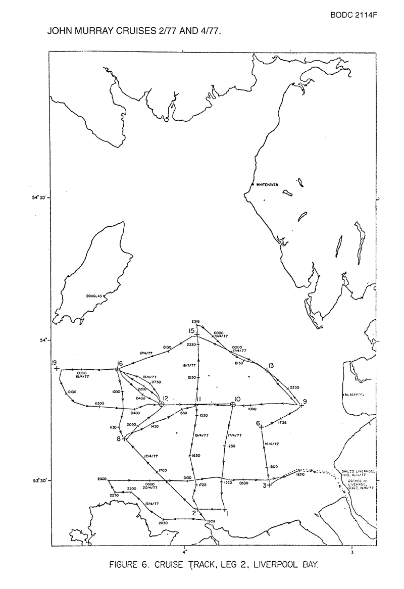
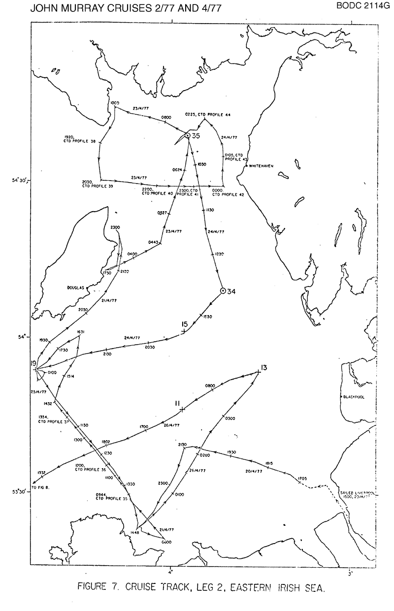
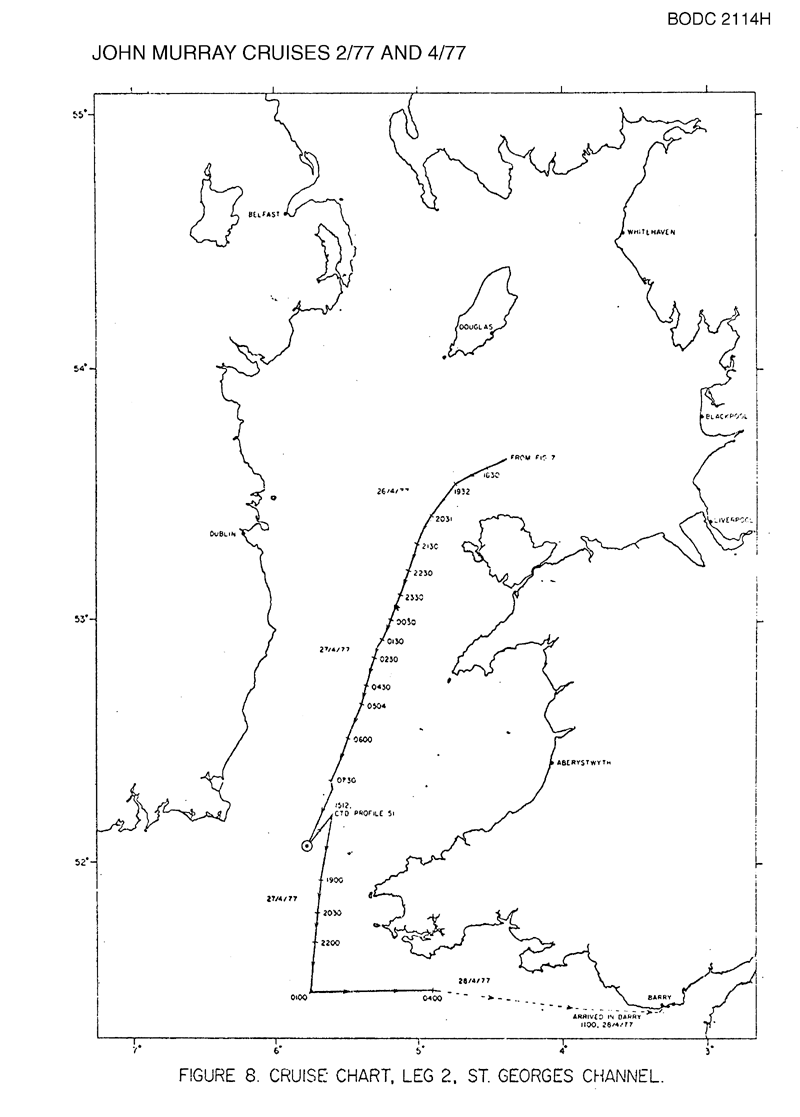
| Objectives and Narrative | Second in a 2-cruise experiment to determine the residual current field in the Eastern Irish Sea using an array of moored current meters, deployed together with an array of bottom-mounted tide-gauge/current meters to determine tidal friction. This cruise recovered the moorings as well as collecting supporting underway temperature/salinity and CTD data. |
| Ship | RRS John Murray |
| Departure Port | Liverpool, United Kingdom |
| Departure Date | 1977-04-16 |
| Arrival Port | Barry, United Kingdom |
| Arrival Date | 1977-04-28 |
| Principal Scientist(s) | Alan J Harrison (Institute of Oceanographic Sciences Bidston Laboratory) |
| Responsible Organisation | Institute of Oceanographic Sciences Bidston Laboratory |
| Associated Project(s) | |
| IHB Sea Areas Visited | Irish Sea and St. George's Channel |
| Marsden Squares Visited | 181;113/181;114/181;124/181;133/181;134/181;143/181;144/181;215/181;225/181;235/181;245 |
| Work Area Description | |
| Unable to lookup cruise bounds at this time | |
| Work Area Bounding Polygon | |
| Southern Limit | unknown |
| Northern Limit | unknown |
| Western Limit | unknown |
| Eastern Limit | unknown |
Cruise Inventory Datasets
| Physical oceanography | |
|---|---|
| CTD stations |
Quantity:
number of stations =
27
Description: |
| Current meters |
Quantity:
number of deployments =
13
Description: 30 days |
| Sea level (inc. bot. press., inverted echosounder) |
Quantity:
number of deployments =
5
Description: 30 days |
| Surface measurements underway (T,S) |
Quantity:
activity duration in days =
13
Description: Recorded throughout cruise |
Cruise Inventory Mooring/Buoy Operations
No information on datasets is currently available
Summary of BODC Data Holdings for the Cruise
National Oceanographic Database
Summary
| # Series | Instrument Description | Parameters |
|---|---|---|
| 27 | CTD/STD cast |
Salinity of the water column Temperature of the water column Vertical spatial coordinates |
Note: Parameter terms are taken from the BODC Parameter Discovery Vocabulary XML (SKOS)
Full List
| BODC Reference | Instrument Description | Date/Time | Location | |
|---|---|---|---|---|
| 548581 | CTD/STD cast | 1977-04-16 13:23Z to 1977-04-16 13:23Z | 53° 29' N, 3° 29' W | Click for more |
| 548593 | CTD/STD cast | 1977-04-16 16:01Z to 1977-04-16 16:02Z | 53° 41' N, 3° 32' W | Click for more |
| 548600 | CTD/STD cast | 1977-04-16 20:00Z to 1977-04-16 20:01Z | 53° 46' N, 3° 17' W | Click for more |
| 548612 | CTD/STD cast | 1977-04-17 07:49Z to 1977-04-17 07:50Z | 53° 46' N, 3° 55' W | Click for more |
| 548624 | CTD/STD cast | 1977-04-17 11:04Z to 1977-04-17 11:06Z | 53° 46' N, 3° 42' W | Click for more |
| 548636 | CTD/STD cast | 1977-04-17 15:01Z to 1977-04-17 15:02Z | 53° 24' N, 3° 46' W | Click for more |
| 548648 | CTD/STD cast | 1977-04-17 19:52Z to 1977-04-17 19:53Z | 53° 39' N, 4° 22' W | Click for more |
| 548661 | CTD/STD cast | 1977-04-18 05:03Z to 1977-04-18 05:04Z | 53° 46' N, 4° 8' W | Click for more |
| 548673 | CTD/STD cast | 1977-04-18 09:38Z to 1977-04-18 09:41Z | 53° 54' N, 4° 24' W | Click for more |
| 548685 | CTD/STD cast | 1977-04-19 18:35Z to 1977-04-19 18:36Z | 53° 24' N, 3° 54' W | Click for more |
| 548697 | CTD/STD cast | 1977-04-21 09:49Z to 1977-04-21 09:50Z | 53° 29' N, 4° 15' W | Click for more |
| 548704 | CTD/STD cast | 1977-04-21 12:06Z to 1977-04-21 12:09Z | 53° 37' N, 4° 25' W | Click for more |
| 548716 | CTD/STD cast | 1977-04-21 13:51Z to 1977-04-21 13:53Z | 53° 45' N, 4° 35' W | Click for more |
| 548728 | CTD/STD cast | 1977-04-23 19:21Z to 1977-04-23 19:22Z | 54° 37' N, 4° 24' W | Click for more |
| 548741 | CTD/STD cast | 1977-04-23 20:33Z to 1977-04-23 20:35Z | 54° 30' N, 4° 24' W | Click for more |
| 548753 | CTD/STD cast | 1977-04-23 22:04Z to 1977-04-23 22:05Z | 54° 29' N, 4° 6' W | Click for more |
| 548765 | CTD/STD cast | 1977-04-23 23:12Z to 1977-04-23 23:13Z | 54° 28' N, 3° 53' W | Click for more |
| 548777 | CTD/STD cast | 1977-04-24 00:05Z to 1977-04-24 00:06Z | 54° 28' N, 3° 43' W | Click for more |
| 548789 | CTD/STD cast | 1977-04-24 01:05Z to 1977-04-24 01:10Z | 54° 34' N, 3° 43' W | Click for more |
| 548790 | CTD/STD cast | 1977-04-24 02:25Z to 1977-04-24 02:26Z | 54° 42' N, 3° 49' W | Click for more |
| 548808 | CTD/STD cast | 1977-04-24 09:29Z to 1977-04-24 09:31Z | 54° 39' N, 3° 54' W | Click for more |
| 548821 | CTD/STD cast | 1977-04-24 14:23Z to 1977-04-24 14:24Z | 54° 9' N, 3° 42' W | Click for more |
| 548833 | CTD/STD cast | 1977-04-24 19:26Z to 1977-04-24 19:27Z | 54° 0' N, 3° 54' W | Click for more |
| 548845 | CTD/STD cast | 1977-04-25 09:19Z to 1977-04-25 09:20Z | 53° 53' N, 4° 46' W | Click for more |
| 548857 | CTD/STD cast | 1977-04-26 06:19Z to 1977-04-26 06:20Z | 53° 53' N, 3° 30' W | Click for more |
| 548869 | CTD/STD cast | 1977-04-27 13:49Z to 1977-04-27 13:53Z | 52° 4' N, 5° 46' W | Click for more |
| 548870 | CTD/STD cast | 1977-04-27 15:09Z to 1977-04-27 15:11Z | 52° 12' N, 5° 36' W | Click for more |
Project Database
No data currently held for this cruise in the BODC Project Database
