BODC Cruise Metadata Report for Poseidon (06PO) cruise PO328
Introduction
This report collates information from the BODC cruise inventory and oceanographic databases. It presents
- Cruise Inventory Information
- A summary of BODC data holdings for the cruise from the
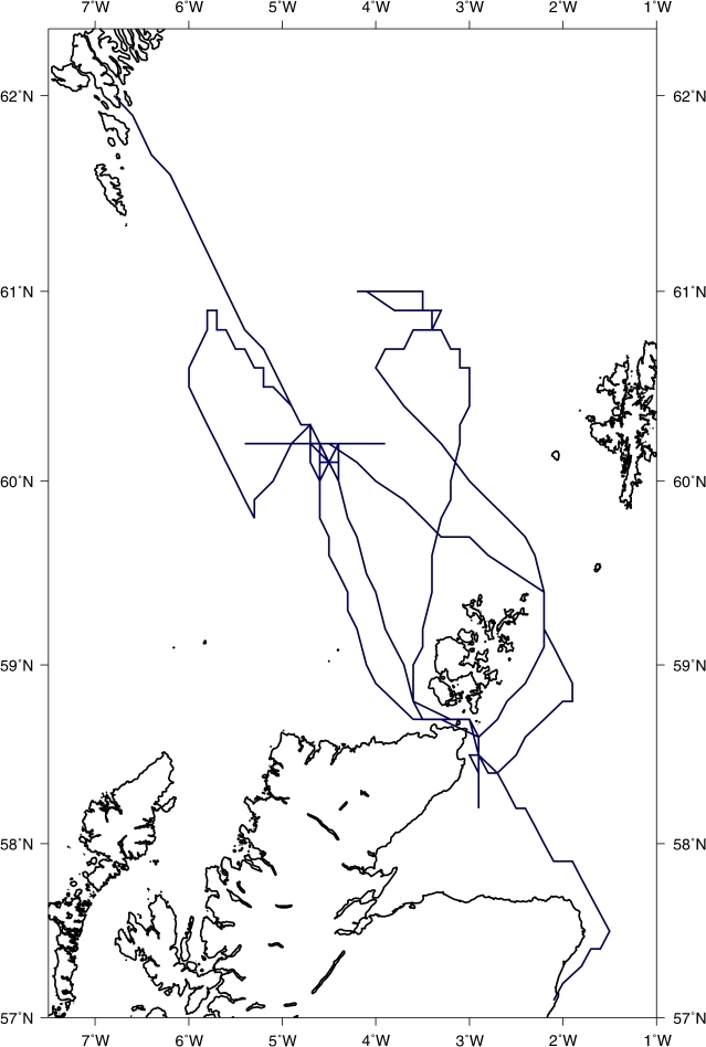
- References - including cruise tracks and cruise reports
Cruise Inventory Information
| Long name | Poseidon (06PO) cruise PO328 |
|---|---|
| Short name | PO328 |
| Objectives and Narrative |
Overall objectives in the POL science programme to 2007 include estimates of slope mixing and some of its oceanic effects. As part of this, objectives a) on the cruise were to make measurements to enable estimates of internal waves and their induced mixing and bottom boundary layer forms (over the West Shetland slope), and to enable the estimates to be related to context: slope, stratification, mean flow. [In the wider project, further allied objectives are: b) to derive, using 3-D fine-resolution and specialist process models for extrapolation, an estimated effect on the characteristics of water flowing adjacent to slopes with (internal-wave-induced) mixing; c) to estimate, using 3-D fine-resolution models for extrapolation, the role slope mixing and associated processes such as water mass transformation, play in cross-slope exchange of mass, heat, salt and nutrients].
Specific objectives for F.S. Poseidon cruise 328 were to (i) deploy and recover four ADCP moorings, three adjacent temperature-logger moorings and the specialist rigs STABLE, HOMER and NIOZ Lander and fast-sampling thermistor string, altogether in a ~ 7km cross near the 500m depth contour, (ii) carry out CTD (+LADCP) surveys of cross-slope centred on the mooring array and ~70 km to the east and west, (iii) carry out repeat (24-hr) CTD (+LADCP) stations, sequences of CTD (+LADCP) stations following any identified internal wave packets and record ship-borne ADCP, all for internal wave behaviour, (iv) obtain satellite images, underway surface and meteorological measurements as context information. |
| Ship | Poseidon |
| Departure Port | Tórshavn, Faroe Islands |
| Departure Date | 2005-09-06 |
| Arrival Port | Aberdeen, United Kingdom |
| Arrival Date | 2005-09-25 |
| Principal Scientist(s) | John Huthnance (Proudman Oceanographic Laboratory) |
| Responsible Organisation | Proudman Oceanographic Laboratory |
| Associated Project(s) | Shelf-sea processes and function; POL Science Plan 2001-07 prog. 2 |
| IHB Sea Areas Visited | North Sea, North East Atlantic Ocean (limit 40W), Unknown |
| Marsden Squares Visited | 181/217 |
| Work Area Description | Faroe-Shetland Channel (West Shetland slope), 3deg - 6deg W, 59.5deg - 61.0deg N. |
| Unable to lookup cruise bounds at this time | |
| Work Area Bounding Polygon | |
| Southern Limit | unknown |
| Northern Limit | unknown |
| Western Limit | unknown |
| Eastern Limit | unknown |
Cruise Inventory Datasets
| Physical oceanography | |
|---|---|
| CTD stations |
Quantity:
number of profiles =
105
Description: Seabird SBE 9plus; conductivity (giving salinity), temperature, depth. Casts 13-37, 38-57, 83-99, 100-105 form sections. 24-hour station casts 58-82. Salinity samples taken every 4-hour watch (more often initially) for calibration analysis by UKORS. |
| Current profiler (eg ADCP) |
Quantity:
number of profiles =
97
Description: 300kHz ADCP lowered with CTD, giving profiles. Cast groupings as above. |
| Current profiler (eg ADCP) |
Quantity:
activity duration in days =
12
Description: Vessel-mounted 75kHz ADCP. Includes 24-hour station: 0546, 11/9/05 to 0637, 12/9/05; repeat section: 0713 to 2155, 12/9/05. Records (Sept.) 6-13, 15-17, 19-22. |
| Surface measurements underway (T,S) |
Quantity:
activity duration in days =
19
Description: Ships continuous surface (2 m depth) recording system: temperature, conductivity, salinity, sigma (density) |
| Meteorology | |
| Routine standard measurements |
Quantity:
activity duration in days =
19
Description: Ships continuous meteorological recording system: wind speed (S/P), direction (S/P), air temperature, relative humidity, pressure, water temperature |
| Geology and geophysics | |
| Single-beam echosounding |
Quantity:
activity duration in days =
19
Description: Ships continuous echo-sounder recording system: depth; uncalibrated but discriminates between different charts in Faroe-Shetland Channel. |
Cruise Inventory Mooring/Buoy Operations
| Latitude | Longitude | Data type | Description |
|---|---|---|---|
| 60° 13' N | 4° 39' W | CTD stations | SM02Ch = HOMER, 597 m depth; 300kHz bottom-frame ADCP and yo-yo fast-sampling temperature to 150m above; deployed (released from surface) 7 Sept. 2005 at 0920, recovered on board 21 Sept. at 0955. [Data from yo-yo shear sensor lost]. |
| 60° 13' N | 4° 39' W | Current meters | SM01Cs = STABLE, 593 m depth; pair EMCMs and temperature at 0.3 and at 0.6 m ab, 3-frequency Acoustic back-scatter at 1.22 mab, rotors at 0.33, 0.51, 0.69, 0.87 m ab and vane above; deployed (released from surface) 7 Sept. 2005 at 0805, recovered on board Pelagia 1 Oct. at 0718. |
| 60° 13' N | 4° 39' W | Current meters | SM02Ch = HOMER, 597 m depth; 300kHz bottom-frame ADCP and yo-yo fast-sampling temperature to 150m above; deployed (released from surface) 7 Sept. 2005 at 0920, recovered on board 21 Sept. at 0955. [Data from yo-yo shear sensor lost]. |
| 60° 13' N | 4° 39' W | Current profiler (eg ADCP) | SM02Ch = HOMER, 597 m depth; 300kHz bottom-frame ADCP and yo-yo fast-sampling temperature to 150m above; deployed (released from surface) 7 Sept. 2005 at 0920, recovered on board 21 Sept. at 0955. [Data from yo-yo shear sensor lost]. |
| 60° 13' N | 4° 40' W | Current profiler (eg ADCP) | SM03Cn = NIOZ lander, 598 m depth; 300kHz bottom-frame ADCP, 2 MHz Nortek AquaDopp current meter, both ~1.75 mab, 112 thermistors every 0.5 m sampling each 2 s, 2 MHz Nortek AquaDopp current meter ~ 88 mab; deployed (released from surface) 7 Sept. 2005 at 1159, recovered on board 21 Sept. at 1128 (thermistors), 1140 (lander). Short, uncalibrated thermistor records, 9 failed. |
| 60° 12' N | 4° 42' W | Current profiler (eg ADCP) | SM04Wc = 150kHz bottom-frame ADCP and temperature, 599 m depth; deployed (released from surface) 7 Sept. 2005 at 1330, recovered on board 21 Sept. at 0809. |
| 60° 15' N | 4° 41' W | Current profiler (eg ADCP) | SM06Nc = 75kHz moored ADCP, 653 m depth; deployed (released from surface) 7 Sept. 2005 at 1703, recovered on board Pelagia 30 Sept. at 1802. |
| 60° 14' N | 4° 37' W | Current profiler (eg ADCP) | SM07Ec = 600kHz bottom-frame ADCP, 597 m depth; deployed (released from surface) 8 Sept. 2005 at 0724, recovered on board 21 Sept. at 0644. |
| 60° 12' N | 4° 38' W | Current profiler (eg ADCP) | SM09Sc = 150kHz bottom-frame ADCP and temperature, 553 m depth; deployed (released from surface) 8 Sept. 2005 at 0946, recovered on board 21 Sept. at 1230. |
| 60° 13' N | 4° 39' W | Other physical oceanographic measurements | SM02Ch = HOMER, 597 m depth; 300kHz bottom-frame ADCP and yo-yo fast-sampling temperature to 150m above; deployed (released from surface) 7 Sept. 2005 at 0920, recovered on board 21 Sept. at 0955. [Data from yo-yo shear sensor lost]. |
| 60° 13' N | 4° 42' W | Other physical oceanographic measurements | SM05Wt = microcat (lowest; temperature and conductivity) and 12 mini-loggers (temperature) @ 4m intervals on line, 601 m depth; deployed (released from surface) 7 Sept. 2005 at 1500, recovered on board 21 Sept. at 0841. |
| 60° 14' N | 4° 37' W | Other physical oceanographic measurements | SM08Et = microcat (lowest; temperature and conductivity) and 12 mini-loggers (temperature) @ 4m intervals on line, 597 m depth; deployed (released from surface) 8 Sept. 2005 at 0827, recovered on board 21 Sept. at 0701. |
| 60° 13' N | 4° 40' W | Subsurface temperature measurements | SM03Cn = NIOZ lander, 598 m depth; 300kHz bottom-frame ADCP, 2 MHz Nortek AquaDopp current meter, both ~1.75 mab, 112 thermistors every 0.5 m sampling each 2 s, 2 MHz Nortek AquaDopp current meter ~ 88 mab; deployed (released from surface) 7 Sept. 2005 at 1159, recovered on board 21 Sept. at 1128 (thermistors), 1140 (lander). Short, uncalibrated thermistor records, 9 failed. |
| 60° 13' N | 4° 42' W | Subsurface temperature measurements | SM05Wt = microcat (lowest; temperature and conductivity) and 12 mini-loggers (temperature) @ 4m intervals on line, 601 m depth; deployed (released from surface) 7 Sept. 2005 at 1500, recovered on board 21 Sept. at 0841. |
| 60° 14' N | 4° 37' W | Subsurface temperature measurements | SM08Et = microcat (lowest; temperature and conductivity) and 12 mini-loggers (temperature) @ 4m intervals on line, 597 m depth; deployed (released from surface) 8 Sept. 2005 at 0827, recovered on board 21 Sept. at 0701. |
| 60° 12' N | 4° 38' W | Subsurface temperature measurements | SM10St = 12 mini-loggers (temperature) @ 4m intervals on line, 556 m depth; deployed (released from surface) 8 Sept. 2005 at 1034, recovered on board 21 Sept. at 1256. |
Summary of BODC Data Holdings for the Cruise
National Oceanographic Database
Summary
| # Series | Instrument Description | Parameters |
|---|---|---|
| 2 | Moored CTD |
Date and time Electrical conductivity of the water column Reference numbers Salinity of the water column Sea level Temperature of the water column |
| 37 | Water temperature and/or salinity monitor |
Date and time Reference numbers Temperature of the water column |
Note: Parameter terms are taken from the BODC Parameter Discovery Vocabulary XML (SKOS)
Full List
| BODC Reference | Instrument Description | Date/Time | Location | |
|---|---|---|---|---|
| 1170278 | Water temperature and/or salinity monitor | 2005-09-07 06:00Z to 2005-09-22 17:20Z | 60° 14' N, 4° 37' W | Click for more |
| 1170291 | Water temperature and/or salinity monitor | 2005-09-07 06:00Z to 2005-09-22 19:02Z | 60° 14' N, 4° 37' W | Click for more |
| 1170309 | Water temperature and/or salinity monitor | 2005-09-07 06:00Z to 2005-09-22 15:32Z | 60° 14' N, 4° 37' W | Click for more |
| 1170310 | Water temperature and/or salinity monitor | 2005-09-07 06:00Z to 2005-09-22 17:52Z | 60° 14' N, 4° 37' W | Click for more |
| 1170322 | Water temperature and/or salinity monitor | 2005-09-07 06:00Z to 2005-09-22 17:28Z | 60° 14' N, 4° 37' W | Click for more |
| 1170334 | Water temperature and/or salinity monitor | 2005-09-07 06:00Z to 2005-09-22 19:20Z | 60° 14' N, 4° 37' W | Click for more |
| 1170346 | Water temperature and/or salinity monitor | 2005-09-07 06:00Z to 2005-09-22 18:12Z | 60° 14' N, 4° 37' W | Click for more |
| 1170358 | Water temperature and/or salinity monitor | 2005-09-07 06:00Z to 2005-09-22 18:30Z | 60° 14' N, 4° 37' W | Click for more |
| 1170371 | Water temperature and/or salinity monitor | 2005-09-07 06:00Z to 2005-09-22 17:04Z | 60° 14' N, 4° 37' W | Click for more |
| 1170383 | Water temperature and/or salinity monitor | 2005-09-07 06:00Z to 2005-09-22 18:02Z | 60° 14' N, 4° 37' W | Click for more |
| 1170395 | Water temperature and/or salinity monitor | 2005-09-07 06:00Z to 2005-09-22 17:38Z | 60° 14' N, 4° 37' W | Click for more |
| 1170402 | Water temperature and/or salinity monitor | 2005-09-07 06:00Z to 2005-09-22 17:12Z | 60° 14' N, 4° 37' W | Click for more |
| 1170414 | Water temperature and/or salinity monitor | 2005-09-07 06:00Z to 2005-09-23 14:20Z | 60° 12' N, 4° 38' W | Click for more |
| 1170426 | Water temperature and/or salinity monitor | 2005-09-07 06:00Z to 2005-09-23 14:00Z | 60° 12' N, 4° 38' W | Click for more |
| 1170438 | Water temperature and/or salinity monitor | 2005-09-07 06:00Z to 2005-09-23 13:54Z | 60° 12' N, 4° 38' W | Click for more |
| 1170451 | Water temperature and/or salinity monitor | 2005-09-07 06:00Z to 2005-09-23 13:44Z | 60° 12' N, 4° 38' W | Click for more |
| 1170463 | Water temperature and/or salinity monitor | 2005-09-07 06:00Z to 2005-09-23 13:40Z | 60° 12' N, 4° 38' W | Click for more |
| 1170475 | Water temperature and/or salinity monitor | 2005-09-07 06:00Z to 2005-09-23 13:32Z | 60° 12' N, 4° 38' W | Click for more |
| 1170487 | Water temperature and/or salinity monitor | 2005-09-07 06:00Z to 2005-09-23 13:22Z | 60° 12' N, 4° 38' W | Click for more |
| 1170499 | Water temperature and/or salinity monitor | 2005-09-07 06:00Z to 2005-09-23 13:16Z | 60° 12' N, 4° 38' W | Click for more |
| 1170506 | Water temperature and/or salinity monitor | 2005-09-07 06:00Z to 2005-09-23 13:00Z | 60° 12' N, 4° 38' W | Click for more |
| 1170518 | Water temperature and/or salinity monitor | 2005-09-07 06:00Z to 2005-09-23 12:52Z | 60° 12' N, 4° 38' W | Click for more |
| 1170531 | Water temperature and/or salinity monitor | 2005-09-07 06:00Z to 2005-09-23 12:44Z | 60° 12' N, 4° 38' W | Click for more |
| 1170543 | Water temperature and/or salinity monitor | 2005-09-07 06:00Z to 2005-09-23 12:36Z | 60° 12' N, 4° 38' W | Click for more |
| 1170555 | Water temperature and/or salinity monitor | 2005-09-07 06:00Z to 2005-09-23 12:28Z | 60° 12' N, 4° 38' W | Click for more |
| 1170567 | Water temperature and/or salinity monitor | 2005-09-07 06:00Z to 2005-09-23 10:28Z | 60° 13' N, 4° 42' W | Click for more |
| 1170579 | Water temperature and/or salinity monitor | 2005-09-07 06:00Z to 2005-09-23 10:16Z | 60° 13' N, 4° 42' W | Click for more |
| 1170580 | Water temperature and/or salinity monitor | 2005-09-07 06:00Z to 2005-09-23 10:08Z | 60° 13' N, 4° 42' W | Click for more |
| 1170592 | Water temperature and/or salinity monitor | 2005-09-07 06:00Z to 2005-09-23 10:00Z | 60° 13' N, 4° 42' W | Click for more |
| 1170611 | Water temperature and/or salinity monitor | 2005-09-07 06:00Z to 2005-09-23 09:54Z | 60° 13' N, 4° 42' W | Click for more |
| 1170623 | Water temperature and/or salinity monitor | 2005-09-07 06:00Z to 2005-09-23 09:48Z | 60° 13' N, 4° 42' W | Click for more |
| 1170635 | Water temperature and/or salinity monitor | 2005-09-07 06:00Z to 2005-09-23 09:36Z | 60° 13' N, 4° 42' W | Click for more |
| 1170647 | Water temperature and/or salinity monitor | 2005-09-07 06:00Z to 2005-09-23 08:24Z | 60° 13' N, 4° 42' W | Click for more |
| 1170659 | Water temperature and/or salinity monitor | 2005-09-07 06:00Z to 2005-09-23 08:04Z | 60° 13' N, 4° 42' W | Click for more |
| 1170660 | Water temperature and/or salinity monitor | 2005-09-07 06:00Z to 2005-09-23 07:38Z | 60° 13' N, 4° 42' W | Click for more |
| 1170672 | Water temperature and/or salinity monitor | 2005-09-07 06:00Z to 2005-09-22 14:52Z | 60° 12' N, 4° 38' W | Click for more |
| 1170684 | Water temperature and/or salinity monitor | 2005-09-07 06:00Z to 2005-09-22 15:20Z | 60° 12' N, 4° 42' W | Click for more |
| 1170696 | Moored CTD | 2005-09-08 12:00Z to 2005-09-21 16:14Z | 60° 14' N, 4° 37' W | Click for more |
| 1170703 | Moored CTD | 2005-09-08 12:00Z to 2005-09-21 15:11Z | 60° 13' N, 4° 42' W | Click for more |
Project Database
| # Events | Gear Type | Parameters Held |
|---|---|---|
| 105 | CTD frame plus rosette sampler |
Salinity of the water column
Dissolved oxygen parameters in the water column Temperature of the water column Density of the water column |
Note: Parameter terms are taken from the BODC Parameter Discovery Vocabulary XML (SKOS)
