BODC Cruise Metadata Report for Magnus Heinason cruise MH08/01
Introduction
This report collates information from the BODC cruise inventory and oceanographic databases. It presents
- Cruise Inventory Information
- A summary of BODC data holdings for the cruise from the
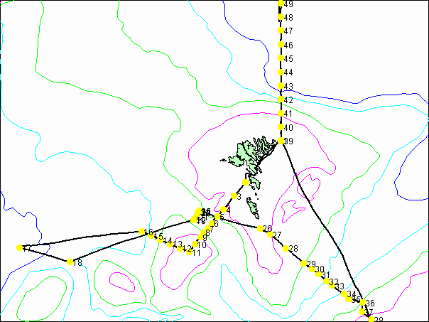
- References - including cruise tracks and cruise reports
Cruise Inventory Information
| Long name | Magnus Heinason cruise MH08/01 |
|---|---|
| Short name | MH08/01 |
| Objectives and Narrative | Hydrographic investigations, standard sections |
| Ship | Magnus Heinason |
| Departure Port | Tórshavn, Faroe Islands |
| Departure Date | 2001-02-22 |
| Arrival Port | Tórshavn, Faroe Islands |
| Arrival Date | 2001-02-28 |
| Principal Scientist(s) | Bogi Hansen (Faroese Fisheries Laboratory) |
| Responsible Organisation | Faroese Fisheries Laboratory |
| Associated Project(s) | Part TRACTOR |
| IHB Sea Areas Visited | Norwegian Sea, North East Atlantic Ocean (limit 40W) |
| Marsden Squares Visited | 217;2 |
| Work Area Description | Faroese waters |
| Unable to lookup cruise bounds at this time | |
| Work Area Bounding Polygon | |
| Southern Limit | unknown |
| Northern Limit | unknown |
| Western Limit | unknown |
| Eastern Limit | unknown |
Cruise Inventory Datasets
| Physical oceanography | |
|---|---|
| CTD stations |
Quantity:
number of stations =
41
Description: t & S at SF6 levels only |
| Current meters |
Quantity:
number of recoveries =
2
Description: 2 moorings recovered, laid July 2000 |
| Subsurface temperature measurements |
Quantity:
number of deployments =
5
Description: 5 moorings laid |
| Water bottle stations |
Quantity:
number of stations =
41
Description: |
| Chemical oceanography | |
| Other dissolved gases |
Quantity:
number of stations =
3
Description: Dissolved sulphur hexafluoride TRACTOR |
| Biology and fisheries | |
| Phytoplankton |
Quantity:
number of stations =
20
Description: |
| Phytoplankton pigs (eg chlorophyll, fluorescence) |
Quantity:
number of stations =
41
Description: |
Cruise Inventory Mooring/Buoy Operations
| Latitude | Longitude | Data type | Description |
|---|---|---|---|
| 60° 52' N | 11° 34' W | Current meters | Recovered mooring, laid July 2000 |
| 61° 1' N | 12° 52' W | Current meters | Recovered mooring, laid July 2000 |
| 61° 28' N | 8° 13' W | Subsurface temperature measurements | Deployed mooring |
| 61° 22' N | 8° 22' W | Subsurface temperature measurements | Deployed mooring |
| 61° 28' N | 8° 13' W | Subsurface temperature measurements | Deployed mooring |
| 61° 22' N | 8° 21' W | Subsurface temperature measurements | Deployed mooring |
| 61° 27' N | 8° 13' W | Subsurface temperature measurements | Deployed mooring |
Summary of BODC Data Holdings for the Cruise
National Oceanographic Database
Summary
| # Series | Instrument Description | Parameters |
|---|---|---|
| 24 | CTD/STD cast |
Salinity of the water column Temperature of the water column Vertical spatial coordinates |
Note: Parameter terms are taken from the BODC Parameter Discovery Vocabulary XML (SKOS)
Full List
| BODC Reference | Instrument Description | Date/Time | Location | |
|---|---|---|---|---|
| 583960 | CTD/STD cast | 2001-02-25 09:17Z | 61° 16' N, 6° 37' W | Click for more |
| 583972 | CTD/STD cast | 2001-02-25 10:14Z | 61° 12' N, 6° 22' W | Click for more |
| 583984 | CTD/STD cast | 2001-02-25 11:52Z | 61° 1' N, 5° 57' W | Click for more |
| 583996 | CTD/STD cast | 2001-02-25 13:40Z | 60° 51' N, 5° 28' W | Click for more |
| 584011 | CTD/STD cast | 2001-02-25 14:50Z | 60° 46' N, 5° 16' W | Click for more |
| 584023 | CTD/STD cast | 2001-02-25 15:55Z | 60° 43' N, 5° 6' W | Click for more |
| 584035 | CTD/STD cast | 2001-02-25 17:15Z | 60° 37' N, 4° 54' W | Click for more |
| 584047 | CTD/STD cast | 2001-02-25 18:25Z | 60° 34' N, 4° 45' W | Click for more |
| 584059 | CTD/STD cast | 2001-02-25 20:04Z | 60° 28' N, 4° 25' W | Click for more |
| 584060 | CTD/STD cast | 2001-02-26 00:51Z | 60° 25' N, 4° 19' W | Click for more |
| 584072 | CTD/STD cast | 2001-02-26 02:27Z | 60° 22' N, 3° 57' W | Click for more |
| 584084 | CTD/STD cast | 2001-02-26 03:30Z | 60° 16' N, 3° 58' W | Click for more |
| 584096 | CTD/STD cast | 2001-02-26 04:50Z | 60° 10' N, 3° 43' W | Click for more |
| 584103 | CTD/STD cast | 2001-02-26 22:56Z | 62° 19' N, 6° 4' W | Click for more |
| 584115 | CTD/STD cast | 2001-02-27 02:21Z | 62° 30' N, 6° 4' W | Click for more |
| 584127 | CTD/STD cast | 2001-02-27 05:22Z | 62° 40' N, 6° 4' W | Click for more |
| 584139 | CTD/STD cast | 2001-02-27 07:14Z | 62° 49' N, 6° 4' W | Click for more |
| 584140 | CTD/STD cast | 2001-02-27 09:29Z | 63° 0' N, 6° 4' W | Click for more |
| 584152 | CTD/STD cast | 2001-02-27 11:27Z | 63° 10' N, 6° 4' W | Click for more |
| 584164 | CTD/STD cast | 2001-02-27 13:22Z | 63° 19' N, 6° 4' W | Click for more |
| 584176 | CTD/STD cast | 2001-02-27 15:38Z | 63° 30' N, 6° 4' W | Click for more |
| 584188 | CTD/STD cast | 2001-02-27 17:30Z | 63° 40' N, 6° 4' W | Click for more |
| 584207 | CTD/STD cast | 2001-02-27 19:24Z | 63° 49' N, 6° 4' W | Click for more |
| 584219 | CTD/STD cast | 2001-02-27 21:15Z | 64° 0' N, 6° 4' W | Click for more |
Project Database
No data currently held for this cruise in the BODC Project Database
