Metadata Report for BODC Series Reference Number 1221317
Metadata Summary
Problem Reports
Data Access Policy
Narrative Documents
Project Information
Data Activity or Cruise Information
Fixed Station Information
BODC Quality Flags
SeaDataNet Quality Flags
Metadata Summary
Data Description |
|||||||||||||||||||||||||||||||||
|
|||||||||||||||||||||||||||||||||
Data Identifiers |
|||||||||||||||||||||||||||||||||
|
|||||||||||||||||||||||||||||||||
Time Co-ordinates(UT) |
|||||||||||||||||||||||||||||||||
|
|||||||||||||||||||||||||||||||||
Spatial Co-ordinates | |||||||||||||||||||||||||||||||||
|
|||||||||||||||||||||||||||||||||
Parameters |
|||||||||||||||||||||||||||||||||
|
|||||||||||||||||||||||||||||||||
|
|||||||||||||||||||||||||||||||||
Problem Reports
No Problem Report Found in the Database
JC088 MetOcean SVP-Iridium Drifter Data Quality Report
End of normal operation
The data originator in collaboration with BODC has identified the following likely point in time at which each drifter is no longer considered to be operating in its intended state, the reason which has been inferred for this end and the explanation for this determination:
| Drifter number | Date of last data cycle in data banked by BODC | End of normal operation | Reason for end of normal operation | Explanation for end of normal operation |
| 1 | 06/01/2014 | N/A | N/A | Worked until end of data |
| 2 | 18/11/2013 | 08/11/2013 | Grounded | Stationary position |
| 12/11/2013 | Refloated | Moving again | ||
| 16/11/2013 | Grounded | Stationary position with GEBCO depths ~70m | ||
| 3 | 06/01/2014 | N/A | N/A | Worked until end of data |
| 4 | 05/01/2014 | 01/01/2014 | Grounded | Stationary position, sustained increase in strain count, less regular transmissions |
| 5 | 27/09/2013 | N/A | N/A | Worked until end of data |
| 6 | N/A | N/A | Failed on deployment | No data available |
| 7 | 22/10/2013 | 12/10/2013 | Grounded | Stationary position |
| 13/10/2013 | Taken ashore | Position moves onto land and temperature decreases, also associated with peak in strain gauge when taken ashore and decrease to zero afterwards | ||
| 8 | 27/09/2013 | N/A | N/A | Worked until end of data |
| 9 | 29/11/2013 | 12/11/2013 | Grounded | Stationary position |
| 14/11/2013 | Refloated | Renewed movement but the drifter is located over GEBCO bathymetry variably < 70 m deep and so might be dragging on seabed | ||
| 20/11/2013 | Drogue loss | Strain gauge decreases to zero and temperature rises to constant extreme value | ||
| 10 | 05/12/2013 | 20/11/2013 | Grounded | Stationary position |
| 04/12/2013 | Picked up by boat | Position moves erratically but quickly ashore and is associated with initial peak in strain gauge | ||
| 11 | 06/01/2014 | 10/12/2013 | Drogue loss | Reduction in strain gauge count and position close to shore near Shetlands |
| 12 | 04/10/2013 | 26/09/2013 | Grounded | Strain gauge peaks on 15/09/13 but no apparent lasting impact. Low movement and GEBCO depths < 70m suggest drogue has grounded and is dragging on seabed from 26/09/13 to end of series. |
| 13 | 19/11/2013 | 11/11/2013 | Dragging | Strain gauge count rises to maximum, possibly dragging on seabed |
| 18/11/2013 | Grounded | Stationary position 18/11/13 | ||
| 19/11/2013 | Exposed to air | Decrease in temperature by >5oC | ||
| 14 | 20/12/2013 | 10/12/2013 | Drogue loss | Consistently low strain gauge values. Pronounced latitudinal oscillations occur from this time onward suggesting greater wind influence. |
| 15 | 11/11/2013 | 19/10/2013 | Grounded | Persistent near-stationary position |
| 28/10/2013 | Exposed to air | Improbably low temperatures between 23-31/10/13 | ||
| 31/10/2013 | Re-immersed | Temperature reverts back to similar values to earlier in series | ||
| 16 | 04/10/2013 | 28/09/2013 | Grounded | Stationary position |
| 17 | 20/12/2013 | N/A | N/A | Worked until end of data. However rapid transit through the Pentland Firth is accompanied by communications interruption on 02-04/11/13. |
| 18 | 18/09/2013 | 18/09/2013 | Dragging | Close to shore and near 15m contour in GEBCO bathymetry suggesting drogue is dragging on seabed. This coincides with spikes in the strain gauge count. |
| 19 | 04/12/2013 | N/A | N/A | Worked until end of data |
| 20 | 11/09/2013 | 11/09/2013 | Picked up by boat | Rapid movement ashore |
| 21 | 10/09/2013 | 05/09/2013 | Grounded | Stationary position |
| 22 | 16/10/2013 | 14/10/2013 | Grounded | Stationary position near island of Barra in shallow water as checked with GEBOC bathymetry. This coincides with a decrease in temperature which suggests exposure to the air. |
| 23 | 06/01/2014 | 24/12/2013 | Drogue loss | Strain count drops to near zero |
| 24 | 06/01/2014 | N/A | N/A | Worked until end of data |
| 25 | 22/10/2013 | 20/10/2013 | Picked up by boat | Loss of GPS data, large changes in position over short period, variations in temperature and decrease in strain count. |
| 26 | 27/09/2013 | N/A | N/A | Worked until end of data, however there is relatively little movement near the end of the series. Local GEBCO bathymetry is deeper than drogue depth, and so this low level of movement likely reflects slow local circulation. |
| 27 | 22/10/2013 | 17/10/2013 | Picked up by boat | Large changes in position over short period, variations in temperature and drop in strain count. |
| 28 | 04/10/2013 | N/A | N/A | Worked until end of data |
| 29 | 27/09/2013 | N/A | N/A | Worked until end of data |
| 30 | 06/01/2014 | N/A | N/A | Worked until end of data |
N.B. Whilst the drifter may no longer be operating in its intended state, this does not imply that any of the data points are necessarily incorrect. For example the loss of the drogue would mean a drifter is no longer following the movement of water at 15m or 70m depth, instead it is following the movement of the surface water/affected by surface winds, but the positional information remains accurate.
Data Access Policy
Open Data
These data have no specific confidentiality restrictions for users. However, users must acknowledge data sources as it is not ethical to publish data without proper attribution. Any publication or other output resulting from usage of the data should include an acknowledgment.
If the Information Provider does not provide a specific attribution statement, or if you are using Information from several Information Providers and multiple attributions are not practical in your product or application, you may consider using the following:
"Contains public sector information licensed under the Open Government Licence v1.0."
Narrative Documents
Omega KFH series miniature strain gauges
Pre-wired, miniature strain gauges. The series contains linear pattern precision gauges (0.3 mm to 20 mm grids), planar XY pattern (Tee Rosette) (0 / 90°) gauges (0.6 to 6 mm grids) and planar rosette pattern (0 / 45 / 90°) gauges (0.6 to 6 mm grids). All models are available with 1 or 3 meter leads, 120 or 350 nominal resistance (ohms).
Specifications
| Parameter Sub-parameter | Units | Specifications |
| Strain Gauge Construction | Foil strain gauge with embedded measuring grid | |
| Measuring Grid | ||
| Material | Constantan | |
| Thickness | µm (microinch) | 3.8 or 5 (150 or 197) depending upon strain gauge type |
| Carrier | ||
| Material | Polyimide | |
| Thickness | µm (microinch) | 45 ± 10 (1.772 ± 394) |
| Connections | PTFE wire dia. - 0.051 mm approximately 50 mm2 long connected to AWG 28 ribbon cables (PVC insulated) through solder sleeves in 2- or 3-wire configurations | |
| Nominal Resistance | Ω | 120 or 350 depending upon gage |
| Resistance Tolerance | % | ± 0.35 (± 1, with 0.6 mm and 1.5 mm grid length) |
| Gauge Factor | % | Approximately 2 (stated on package) |
| Gauge Factor Tolerance | % | ± 1 (± 1.5, with 0.6 mm and 1.5 mm grid length) |
| Temperature coefficient of gauge factor | 1/K [1/°F] | (115 ± 10) x 10-6 [(64 ± 5.5) x 10-6] |
| Nominal value of gauge factor temperature coefficient | Specified on each package | |
| Reference Temperature | °C (°F) | 23 |
| Operating Temperature Range | PTFE cable | |
| for static measurement (zero point related) | °C (°F) | -10 to 155 (-14 to 320) |
| for dynamic measurement (not zero point related) | °C (°F) | -10 to 155 (-14 to 320) |
Further specifications can be found in the manufacturer's data sheet.
U.S. Sensor Ultra Precision Interchangeable Thermistor
A series of interchangeable, resistive thermistors of electrical component size for use in temperature sensing. Epoxy encapsulated with tinned copper allow wires.
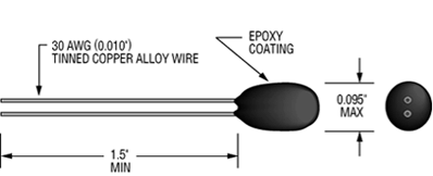 |
Specifications
| Thermal time constant: | 1 second max. in a well stirred oil bath 10 seconds max. in still air |
| Dissipation constant: | 1 mW/°C |
| Maximum power rating: | 30 mW at 25 °C derated to 1 mW at 125 °C |
| Interchangeability tolerance: | ±0.05 °C from 0-50 °C |
| Operating temperature: | -55 °C to +80 °C |
| Storage and operation temperatures for best long term stability: | -55 ° to +50 °C |
| Resistance ranges: | 2,252 - 50,000 Ohms (at 25 °C) |
Navman Jupiter 32 GPS receiver module
A miniature (17.0 x 15.0 mm, 2 g), 20-channel GPS receiver for use in marine buoys. The unit contains a SiRF GSC3 GPS chipset. The Jupiter 32 is the successor to the Jupiter 30. The product was replaced by the Jupiter 32 xLP. Navman Wireless OEM Solutions is now Telit Wireless Solutions.
Sensitivity (assuming a noise value of 3 dB)
| Parameter | Signal strength | C/N0 |
|---|---|---|
| acquisition - cold start | -144 dBm | 26 dBHz |
| acquisition - hot start | -155 dBm | 15 dBHz |
| navigation | -157 dBm | 13 dBHz |
| tracking | -159 dBm | 10 dBHz |
Horizontal and positional accuracy
| Parameter | Value |
|---|---|
| horizontal CEP* | 2.2 m |
| horizontal (2 dRMS) | 5.5 m |
| vertical VEP* | 2.0 m |
| velocity 2D (2 sigma) | TBD |
* position error 50%
Timing 1 PPS output
| 1 PPS output | < 1 µs, typical ±300 ns ref UTC |
Further specifications and information is available in the manufacturer's data sheet.
JC088 MetOcean SVP-Iridium Drifter Processing by BODC
The data to be banked by BODC were received as 30 csv files, one for each drifter along with a separate header file. The file for drifter 6 contained no useful information due to failure on deployment and was therefore not processed. The original real-time data files are archived at BODC and are available upon request.
Parameter Mapping
The received files were reformatted to BODC's internal file format which is a NetCDF subset.
Due to the high variability of the Iridium position Circular Error Probability and numerous associated inaccurate Iridium positions, it was decided that the data should only be sampled at the frequency of the GPS position fixes. All other data cycles were removed at the reformatting stage. Whilst this decreases the temporal resolution of the data, it provides a dataset with reliable positional information upon which useful trajectory and temperature data is reliant.
The following table shows how the variables within the csv files were mapped to appropriate BODC parameter codes:
| Originator's Parameter Name | Units | Description | BODC Parameter Code | Units | Comments |
| IridMsgSN | N/A | Iridium Message Series Number | - | - | EP |
| IridDateTime | dd/mm/yyyy hh:mm | Iridium Date & Time | - | - | GPS Date & Time used |
| IridDateTimeUnix | Unix format Date & Time | Iridium Date & Time in Unix format | - | - | Not required |
| IridLat | Degrees north | Iridium Latitude North | - | - | GPSLat used |
| IridLng | Degrees east | Iridium Longitude East | - | - | GPSLng used |
| IridCEP | Not known | Iridium Circular Error Probability | - | - | EP |
| EmailTime | Not known | Not known | - | - | EP |
| GPSDateTime | dd/mm/yyyy hh:mm | Navman Jupiter 32 GPS Date & Time | AADYAA01 | Days | - |
| AAFDZZ01 | Time | - | |||
| GPSDateTimeUnix | Unix format Date & Time | Navman Jupiter 32 GPS Date & Time in Unix format | - | - | Not required |
| SST(C) | oC | Sea Surface Temperature | TEMPST01 | oC | - |
| StrainGague(count) | Dimensionless | Count of strain exerted by drogue | ENGPSG01 | Dimensionless | Important for determining if the drogue is still attached and if drifter has run aground |
| Battery(V) | V | Battery voltage | - | - | EP |
| SBDTime(sec) | Seconds | Time taken to transmit Iridium Short Burst Data | - | - | EP |
| TimeSinceLastFix(min) | Minutes | Time since the last GPS fix was achieved | - | - | A GPS fix is taken only once every 3 hours. When the value of this parameter does not equal zero, the GPS fix is a repeat of the last fix. |
| GPSLat | Degrees north | Navman Jupiter 32 GPS Latitude | ALATGP01 | Degrees north | - |
| GPSLng | Degrees east | Navman Jupiter 32 GPS Longitude | ALONGP01 | Degrees east | - |
| TimeToFirstFix(sec) | Seconds | Time to first GPS fix | - | - | EP |
| Signal2NoiseRatio(dB) | dB | Signal to noise ratio of GPS module | - | - | EP |
EP = Engineering parameter which is not required for the use of environmental data.
Screening
The reformatted data were visualised using the in-house EDSERPLO software. No data values were edited or deleted at this stage. The improbable data value flag 'M' has been applied where the data appear not to represent valid environmental conditions including strain gauge faults and some instances where the temperature sensor values suggest it has been exposed to the air. Differences in the interval between time stamps exist due to occasional variability in the interval between GPS fixes. Details of the end of each drifter's normal operation are documented in the data quality report.
Banking
Once quality control screening was complete, the data were archived in the BODC National Oceanographic Database and the associated metadata were loaded into an ORACLE Relational Database Management System.
MetOcean SVP-Iridium Drifter Originator Processing
Sampling Strategy
Twenty Metocean SVP drifters were deployed on the shelf break at around 47°35'N as part of cruise D376. The were released in 3 groups and transmitted data including GPS location and sea surface temperature every 3 hours.
For further information please see the D376 cruise report.
Data Processing
The real time drifter data including both environmental and engineering parameters was transmitted through the Iridium satellite network. No processing was undertaken on the data by the originator and the near real-time data was supplied to BODC.
JC088 MetOcean SVP-Iridium Drifter Instrumentation
Thirty MetOcean Surface Velocity Program (SVP)-Iridium drifters were deployed on the European continental shelf break between 55° 12.00' N, 10° 04.52' W and 55° 10.21 N, 10° 05.36 W, on the 17/7/13 to track currents at 15 m and 70 m depth. The SVPs consisted of a spherical surface unit and an underwater holey-sock drogue attached by a long tether.
The surface buoy was made from injection moulded high impact ABS and contained the communications and sensors. It was equipped with a bi-directional Iridium 9601 Short Burst Data transceiver satellite system communications link, which also provided hourly position information. More accurate position information was provided by a Navman Jupiter 32 GPS System module every three hours. The drifter was equipped with a US Sensor Ultra Precision Thermistor sea surface temperature sensor and battery voltage sensor.
The SVP drifter was equipped with a strain gauge drogue presence system to indicate whether the drogue was attached, under increased strain such as during high wave activity or when grounded, or had lost the drogue. The manufacturer supplies the drogue with a tether made from plastic coated stainless steel cable, which centres the drogue at 15m depth (short tether). However the tethers on 15 of the 30 drifters were modified to place the drogues at a depth of 70 m (long tether) to attempt to track water below the mixed layer.
Further information can be found in the product datasheet and the product manual
As described in the cruise report , the drifters were deployed as one group in alternating order (1 long tether, 1 short tether, 1 long tether, and so on) over the 600 m isobath during a period of 1 hour and 20 minutes. The 600 m isobath was chosen as a release site as other experiments had indicated the presence of a slope current in this depth of water.
Project Information
Fluxes Across Sloping Topography of the North East Atlantic (FASTNEt)
Background
The FASTNEt consortium was funded to deliver NERC's Ocean Shelf Edge Exchange Programme. Commencing in October 2011, this four year study aims to couple established observational techniques, such as moorings and CTDs, with the very latest in autonomous sampling initiatives - including use of Autosub Long Range and gliders. With the aid of novel model techniques, these observations will be utilised to construct a new paradigm of Ocean/Shelf exchange.
Shelf edge regions mark the gateway between the world's deep oceans and shallower coastal seas, linking terrestrial, atmospheric and oceanic carbon pools and influencing biogeochemical fluxes. Shelf edge processes can influence near-shore productivity (and fisheries) and ultimately affect global climate.
FASTNEt brings together researchers from multiple UK organisations. Further collaboration has been established with five Project Partners: the UK Met Office, Marine Scotland Science, Agri-Food and Biosciences Institute, Marine Institute Ireland and Scripps Institution of Oceanography.
Scientific Objectives
- To determine the seasonality of physical gradients and exchange across the shelf edge by deploying new observational technologies (gliders, Autosub Long Range) and established techniques (long term moorings, drifters)
- To quantify key exchange mechanisms and to collect new data targeted at testing and improving high resolution models of the shelf edge, by carrying out detailed process studies in contrasting regions of the shelf edge of the NE Atlantic margin
- To develop a new parameterisation of shelf edge exchange processes suitable for regional-scale models, using improved resolution numerical, and new empirical models constrained by the observations
- To test the new parameterisations in a regional model in the context of making an assessment of inter-annual variability of ocean-shelf exchange.
Fieldwork
Three survey sites on the UK shelf edge have been selected for FASTNEt. These are a) the Celtic Sea shelf edge, b) Malin shelf and c) North Scotland shelf. Fieldwork is centred around two research cruises. The first, to the Celtic Sea, on RRS Discovery in June 2012. The second cruise visits the Malin shelf on RRS James Cook, during summer 2013. In addition to these dedicated cruises, opportunist cruise activity to the North Scotland shelf has been agreed with project partner Marine Scotland Science. Autonomous technologies will complement observations made during the cruises and provide knowledge of seasonal and inter-annual variability in exchange processes.
Instrumentation
Types of instruments/measurements:
- Gliders
- Autosub Long Range
- Drifter buoys
- Scanfish
- Microstructure profilers
- Moored CTD/CT loggers and ADCPs
- Shipboard measurements: CTD, underway, nutrients (and other discrete sampling), LADCP, ADCP.
Contacts
| Collaborator | Organisation |
|---|---|
| Prof. Mark Inall (lead) | Scottish Association for Marine Science, U.K |
| Dr. Jason Holt | National Oceanography Centre, U.K |
| Dr. Peter Miller | Plymouth Marine Laboratory, U.K |
| Dr. Mattias Green | Bangor University, U.K |
| Prof. Jonathan Sharples | University of Liverpool, U.K |
| Dr. Vasyl Vlasenko | University of Plymouth, U.K |
Data Activity or Cruise Information
Cruise
| Cruise Name | JC088 |
| Departure Date | 2013-06-28 |
| Arrival Date | 2013-07-24 |
| Principal Scientist(s) | Mark E Inall (Scottish Association for Marine Science) |
| Ship | RRS James Cook |
Complete Cruise Metadata Report is available here
Fixed Station Information
No Fixed Station Information held for the Series
BODC Quality Control Flags
The following single character qualifying flags may be associated with one or more individual parameters with a data cycle:
| Flag | Description |
|---|---|
| Blank | Unqualified |
| < | Below detection limit |
| > | In excess of quoted value |
| A | Taxonomic flag for affinis (aff.) |
| B | Beginning of CTD Down/Up Cast |
| C | Taxonomic flag for confer (cf.) |
| D | Thermometric depth |
| E | End of CTD Down/Up Cast |
| G | Non-taxonomic biological characteristic uncertainty |
| H | Extrapolated value |
| I | Taxonomic flag for single species (sp.) |
| K | Improbable value - unknown quality control source |
| L | Improbable value - originator's quality control |
| M | Improbable value - BODC quality control |
| N | Null value |
| O | Improbable value - user quality control |
| P | Trace/calm |
| Q | Indeterminate |
| R | Replacement value |
| S | Estimated value |
| T | Interpolated value |
| U | Uncalibrated |
| W | Control value |
| X | Excessive difference |
SeaDataNet Quality Control Flags
The following single character qualifying flags may be associated with one or more individual parameters with a data cycle:
| Flag | Description |
|---|---|
| 0 | no quality control |
| 1 | good value |
| 2 | probably good value |
| 3 | probably bad value |
| 4 | bad value |
| 5 | changed value |
| 6 | value below detection |
| 7 | value in excess |
| 8 | interpolated value |
| 9 | missing value |
| A | value phenomenon uncertain |
| B | nominal value |
| Q | value below limit of quantification |
