BODC Cruise Metadata Report for RRS Challenger (74CH) cruise CH12A/75
Introduction
This report collates information from the BODC cruise inventory and oceanographic databases. It presents
- Cruise Inventory Information
- A summary of BODC data holdings for the cruise from the
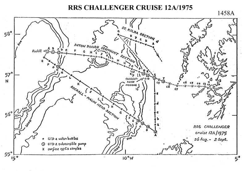
- References - including cruise tracks and cruise reports
Cruise Inventory Information
| Long name | RRS Challenger (74CH) cruise CH12A/75 |
|---|---|
| Short name | CH12A/75 |
| Objectives and Narrative |
The cruise had 6 objectives.
1. Recovery and relaying of a current meter mooring at 57N 9W. 2. Working the hydrographic sections to Anton Dohrn Seamount (Ellett Line) and Rockall and Rockall-Malin Head (Rosemary Bank to St Kilda also worked due to favourable conditions). 3. Using a submersible pump and autoanalyser for nutrient determinations along these sections. 4. Collecting Shipek grab samples of shelf sediments for Aberystwyth University. 5. Collecting large volume water samples for radio-caesium analysis by the Fisheries Radiobiological Laboratory. 6. Transmitting temperature profiles to the Met Office at Bracknell based on STD traces. All objectives were successfully achieved. |
| Ship | RRS Challenger |
| Departure Port | Dunstaffnage, United Kingdom |
| Departure Date | 1975-08-26 |
| Arrival Port | Dunstaffnage, United Kingdom |
| Arrival Date | 1975-09-02 |
| Principal Scientist(s) | David J Ellett (Scottish Marine Biological Association) |
| Responsible Organisation | Scottish Marine Biological Association |
| Associated Project(s) | |
| IHB Sea Areas Visited | Inner Seas off the West Coast of Scotland, North East Atlantic Ocean (limit 40W) |
| Marsden Squares Visited | 181;4/182;3 |
| Work Area Description | Malin Shelf, Rockall, Anton Dohrn Seamount |
| Unable to lookup cruise bounds at this time | |
| Work Area Bounding Polygon | |
| Southern Limit | unknown |
| Northern Limit | unknown |
| Western Limit | unknown |
| Eastern Limit | unknown |
Cruise Inventory Datasets
| Physical oceanography | |
|---|---|
| CTD stations |
Quantity:
number of stations =
21
Description: |
| Chemical oceanography | |
| Radioactivity |
Quantity:
number of samples =
10
Description: surface water samples for radio-caesium analysis. |
| Geology and geophysics | |
| Grab |
Quantity:
number of samples =
30
Description: obtained using Shipek grab. |
Cruise Inventory Mooring/Buoy Operations
No information on datasets is currently available
Summary of BODC Data Holdings for the Cruise
National Oceanographic Database
Summary
| # Series | Instrument Description | Parameters |
|---|---|---|
| 21 | CTD/STD cast |
Salinity of the water column Temperature of the water column Vertical spatial coordinates |
Note: Parameter terms are taken from the BODC Parameter Discovery Vocabulary XML (SKOS)
Full List
| BODC Reference | Instrument Description | Date/Time | Location | |
|---|---|---|---|---|
| 89520 | CTD/STD cast | 1975-08-29 19:35Z | 56° 37' N, 11° 33' W | Click for more |
| 89532 | CTD/STD cast | 1975-08-29 23:05Z | 56° 25' N, 11° 3' W | Click for more |
| 89544 | CTD/STD cast | 1975-08-30 04:05Z | 56° 14' N, 10° 34' W | Click for more |
| 89556 | CTD/STD cast | 1975-08-30 07:11Z | 56° 7' N, 10° 12' W | Click for more |
| 89568 | CTD/STD cast | 1975-08-30 10:03Z | 56° 0' N, 9° 49' W | Click for more |
| 89581 | CTD/STD cast | 1975-08-30 12:06Z | 55° 56' N, 9° 37' W | Click for more |
| 89593 | CTD/STD cast | 1975-08-30 16:35Z | 55° 46' N, 9° 16' W | Click for more |
| 89600 | CTD/STD cast | 1975-08-30 19:10Z | 55° 42' N, 9° 0' W | Click for more |
| 89612 | CTD/STD cast | 1975-08-30 22:03Z | 55° 34' N, 8° 37' W | Click for more |
| 89624 | CTD/STD cast | 1975-08-31 00:40Z | 55° 43' N, 8° 37' W | Click for more |
| 89636 | CTD/STD cast | 1975-08-31 02:40Z | 55° 54' N, 8° 40' W | Click for more |
| 89648 | CTD/STD cast | 1975-08-31 04:10Z | 56° 4' N, 8° 40' W | Click for more |
| 89661 | CTD/STD cast | 1975-08-31 08:53Z | 56° 34' N, 8° 43' W | Click for more |
| 89673 | CTD/STD cast | 1975-08-31 12:10Z | 56° 57' N, 8° 46' W | Click for more |
| 89685 | CTD/STD cast | 1975-08-31 13:40Z | 57° 0' N, 9° 0' W | Click for more |
| 89697 | CTD/STD cast | 1975-08-31 17:00Z | 57° 6' N, 9° 25' W | Click for more |
| 89704 | CTD/STD cast | 1975-09-01 01:12Z | 58° 1' N, 10° 22' W | Click for more |
| 89716 | CTD/STD cast | 1975-09-01 06:41Z | 57° 52' N, 9° 34' W | Click for more |
| 89728 | CTD/STD cast | 1975-09-01 07:49Z | 57° 49' N, 9° 21' W | Click for more |
| 89741 | CTD/STD cast | 1975-09-01 09:00Z | 57° 46' N, 9° 7' W | Click for more |
| 89753 | CTD/STD cast | 1975-09-01 10:38Z | 57° 41' N, 8° 46' W | Click for more |
Project Database
No data currently held for this cruise in the BODC Project Database
