BODC Cruise Metadata Report for FRV Scotia (749S) cruise 0189S_2
Introduction
This report collates information from the BODC cruise inventory and oceanographic databases. It presents
- Cruise Inventory Information
- A summary of BODC data holdings for the cruise from the
- References - including cruise tracks and cruise reports
Cruise Inventory Information
| Long name | FRV Scotia (749S) cruise 0189S_2 |
|---|---|
| Short name | 0189S_2 |
| Objectives and Narrative |
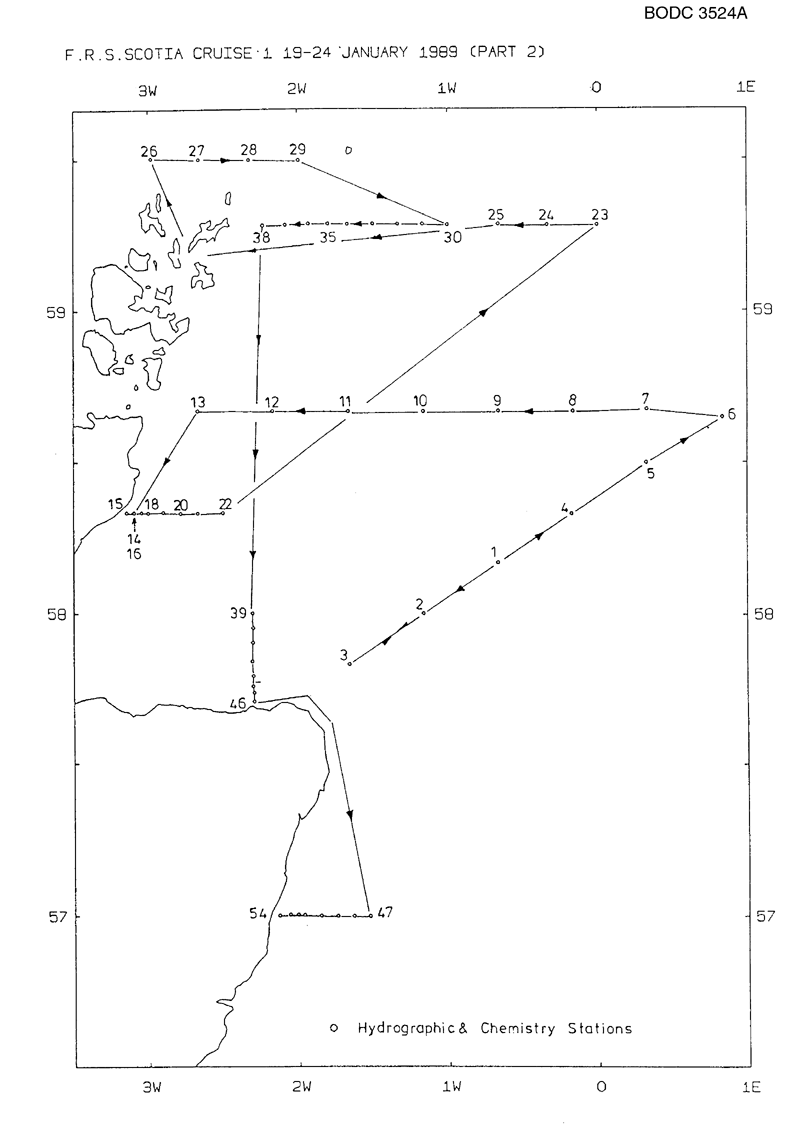
(1) To recover 3 current meter moorings deployed in the North Sea in September 1988.
(2) To creep for one mooring whose surface marker has been removed. (3) To carry out a hydrographic survey in the area of the Fair Isle and Dooley currents in the North Sea and in the area west of Orkney and Shetland. (4) To work hydrogaphic stations along the JONSIS line, and to collect benthich samples along this line. |
| Ship | FRV Scotia |
| Departure Port | Greenock, United Kingdom |
| Departure Date | 1989-01-17 |
| Arrival Port | Aberdeen, United Kingdom |
| Arrival Date | 1989-01-25 |
| Principal Scientist(s) | Bill Turrell (Scottish Office Agriculture and Fisheries Department Aberdeen Marine Laboratory) |
| Responsible Organisation | Scottish Office Agriculture and Fisheries Department Aberdeen Marine Laboratory |
| Associated Project(s) | |
| IHB Sea Areas Visited | North Sea |
| Marsden Squares Visited | 181;3/181;4 |
| Work Area Description | EC line North Sea; Fair Ile, Orkney and Shetland; JONSIS line |
| Unable to lookup cruise bounds at this time | |
| Work Area Bounding Polygon | |
| Southern Limit | unknown |
| Northern Limit | unknown |
| Western Limit | unknown |
| Eastern Limit | unknown |
Cruise Inventory Datasets
| Physical oceanography | |
|---|---|
| CTD stations |
Quantity:
number of stations =
41
Description: |
| Current meters |
Quantity:
number of stations =
4
Description: 7 cms recovered |
| Surface measurements underway (T,S) | Description: run throughout cruise |
| Water bottle stations |
Quantity:
number of stations =
27
Description: |
| Chemical oceanography | |
| Nitrate |
Quantity:
number of stations =
27
Description: |
| Phosphate |
Quantity:
number of stations =
24
Description: |
| Silicate |
Quantity:
number of stations =
24
Description: |
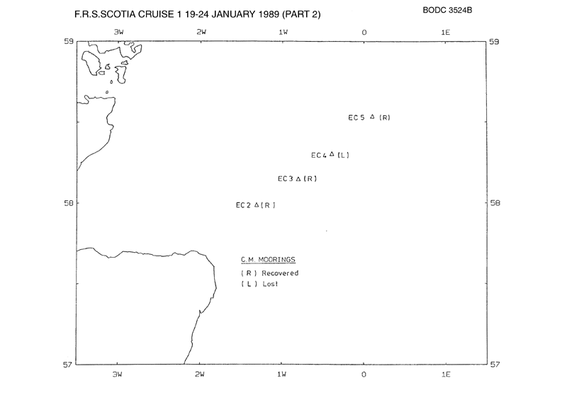
Cruise Inventory Mooring/Buoy Operations
| Latitude | Longitude | Data type | Description |
|---|---|---|---|
| 58° 18' N | 0° 24' W | Current meters | rec. 1cm and parts of mooring ec4 (laid 18.9.88) |
| 58° 32' N | 0° 6' E | Current meters | rec. mooring EC5 with 2cm and WLR (laid 19.9.88) |
| 57° 59' N | 1° 19' W | Current meters | rec. mooring ec2 with 2cm (laid 18.9.88) |
| 58° 9' N | 0° 48' W | Current meters | rec. mooring ec3 with 2cm (laid 18.9.88) |
| 58° 32' N | 0° 6' E | Sea level (inc. bot. press., inverted echosounder) | rec. mooring EC5 with 2cm and WLR (laid 19.9.88) |
Summary of BODC Data Holdings for the Cruise
National Oceanographic Database
Summary
| # Series | Instrument Description | Parameters |
|---|---|---|
| 41 | CTD/STD cast |
Density of the water column Electrical conductivity of the water column Salinity of the water column Temperature of the water column Vertical spatial coordinates |
Note: Parameter terms are taken from the BODC Parameter Discovery Vocabulary XML (SKOS)
Full List
| BODC Reference | Instrument Description | Date/Time | Location | |
|---|---|---|---|---|
| 404797 | CTD/STD cast | 1989-01-19 15:32Z | 58° 10' N, 0° 40' W | Click for more |
| 404804 | CTD/STD cast | 1989-01-19 18:16Z | 58° 0' N, 1° 10' W | Click for more |
| 404816 | CTD/STD cast | 1989-01-19 20:41Z | 57° 49' N, 1° 39' W | Click for more |
| 404828 | CTD/STD cast | 1989-01-20 20:51Z | 58° 19' N, 0° 10' W | Click for more |
| 404841 | CTD/STD cast | 1989-01-20 23:09Z | 58° 30' N, 0° 19' E | Click for more |
| 404853 | CTD/STD cast | 1989-01-21 01:06Z | 58° 39' N, 0° 50' E | Click for more |
| 404865 | CTD/STD cast | 1989-01-21 03:06Z | 58° 40' N, 0° 19' E | Click for more |
| 404877 | CTD/STD cast | 1989-01-21 05:35Z | 58° 40' N, 0° 9' W | Click for more |
| 404889 | CTD/STD cast | 1989-01-21 07:36Z | 58° 40' N, 0° 39' W | Click for more |
| 404890 | CTD/STD cast | 1989-01-21 09:52Z | 58° 40' N, 1° 10' W | Click for more |
| 404908 | CTD/STD cast | 1989-01-21 11:50Z | 58° 40' N, 1° 40' W | Click for more |
| 404921 | CTD/STD cast | 1989-01-21 13:28Z | 58° 40' N, 2° 10' W | Click for more |
| 404933 | CTD/STD cast | 1989-01-21 14:57Z | 58° 40' N, 2° 40' W | Click for more |
| 404945 | CTD/STD cast | 1989-01-21 17:36Z | 58° 19' N, 3° 6' W | Click for more |
| 404957 | CTD/STD cast | 1989-01-21 18:03Z | 58° 19' N, 3° 9' W | Click for more |
| 404969 | CTD/STD cast | 1989-01-21 19:12Z | 58° 19' N, 3° 3' W | Click for more |
| 404970 | CTD/STD cast | 1989-01-21 19:52Z | 58° 19' N, 3° 0' W | Click for more |
| 404982 | CTD/STD cast | 1989-01-21 20:40Z | 58° 19' N, 2° 54' W | Click for more |
| 404994 | CTD/STD cast | 1989-01-21 21:14Z | 58° 19' N, 2° 46' W | Click for more |
| 405008 | CTD/STD cast | 1989-01-21 21:48Z | 58° 19' N, 2° 40' W | Click for more |
| 405021 | CTD/STD cast | 1989-01-21 22:32Z | 58° 19' N, 2° 30' W | Click for more |
| 405033 | CTD/STD cast | 1989-01-23 08:54Z | 59° 30' N, 2° 58' W | Click for more |
| 405045 | CTD/STD cast | 1989-01-23 09:45Z | 59° 30' N, 2° 39' W | Click for more |
| 405057 | CTD/STD cast | 1989-01-23 10:41Z | 59° 30' N, 2° 19' W | Click for more |
| 405069 | CTD/STD cast | 1989-01-23 11:38Z | 59° 30' N, 1° 59' W | Click for more |
| 405070 | CTD/STD cast | 1989-01-24 04:33Z | 58° 0' N, 2° 18' W | Click for more |
| 405082 | CTD/STD cast | 1989-01-24 05:11Z | 57° 57' N, 2° 18' W | Click for more |
| 405094 | CTD/STD cast | 1989-01-24 05:51Z | 57° 54' N, 2° 18' W | Click for more |
| 405101 | CTD/STD cast | 1989-01-24 06:33Z | 57° 50' N, 2° 18' W | Click for more |
| 405113 | CTD/STD cast | 1989-01-24 07:09Z | 57° 47' N, 2° 18' W | Click for more |
| 405125 | CTD/STD cast | 1989-01-24 08:02Z | 57° 45' N, 2° 18' W | Click for more |
| 405137 | CTD/STD cast | 1989-01-24 09:03Z | 57° 44' N, 2° 17' W | Click for more |
| 405149 | CTD/STD cast | 1989-01-24 09:43Z | 57° 42' N, 2° 17' W | Click for more |
| 405150 | CTD/STD cast | 1989-01-24 15:37Z | 57° 0' N, 1° 31' W | Click for more |
| 405162 | CTD/STD cast | 1989-01-24 16:14Z | 57° 0' N, 1° 38' W | Click for more |
| 405174 | CTD/STD cast | 1989-01-24 16:47Z | 57° 0' N, 1° 45' W | Click for more |
| 405186 | CTD/STD cast | 1989-01-24 17:20Z | 57° 0' N, 1° 51' W | Click for more |
| 405198 | CTD/STD cast | 1989-01-24 17:54Z | 57° 0' N, 1° 58' W | Click for more |
| 405205 | CTD/STD cast | 1989-01-24 18:32Z | 57° 0' N, 2° 0' W | Click for more |
| 405217 | CTD/STD cast | 1989-01-24 19:13Z | 57° 0' N, 2° 3' W | Click for more |
| 405229 | CTD/STD cast | 1989-01-24 19:55Z | 57° 0' N, 2° 7' W | Click for more |
Project Database
No data currently held for this cruise in the BODC Project Database
