BODC Cruise Metadata Report for RV Corystes (74RY) cruise COR5/99
Introduction
This report collates information from the BODC cruise inventory and oceanographic databases. It presents
- Cruise Inventory Information
- A summary of BODC data holdings for the cruise from the
- References - including cruise tracks and cruise reports
Cruise Inventory Information
| Long name | RV Corystes (74RY) cruise COR5/99 |
|---|---|
| Short name | COR5/99 |
| Objectives and Narrative |
The work is directed at a better understanding of the dynamics of the circulation processes fringing thecnorth east coast of England, between the Firth of Forth and Flamborough Head, and in vicinity of the Dogger Bank. It is intended to characterise the extent and nature of the density driven and seasonal jet like circulation which acts as a direct and rapid pathway for transport of material from the coastal region to the central North Sea. Subsequently, the knowledge will be viewed with respect to concerns that elevated levels of contaminants on the Dogger Bank have originated in the near coastal region. Additionally, work includes the servicing of a mooring in the vicinity of the Outer Gabbard as part of the National Marine Monitoring Programme.
The main sampling aims of the cruise are: 1. To service a smart mooring at the Outer Gabbard. 2. To deploy five mooring arrays in the vicinity of the Dogger Bank. 3. Deploy free floating satellite tracked buoys in order to determine the Lagrangian circulation. Subsequently, a number may be retrieved. 4. To undertake Scanfish, CTD and grab surveys of the north-east coast and Dogger Bank to collect information on nutrients, suspended sediment and metals. 5. Conduct experiments to examine the near-bed cross frontal circulation. |
| Ship | RV Corystes |
| Departure Port | Lowestoft, United Kingdom |
| Departure Date | 1999-06-14 |
| Arrival Port | Lowestoft, United Kingdom |
| Arrival Date | 1999-07-01 |
| Principal Scientist(s) | Juan Brown (Centre for Environment, Fisheries and Aquaculture Science Lowestoft Laboratory) |
| Responsible Organisation | Centre for Environment, Fisheries and Aquaculture Science Lowestoft Laboratory |
| Associated Project(s) | |
| IHB Sea Areas Visited | North Sea |
| Marsden Squares Visited | 181/216 |
| Work Area Description | Dogger Bank |
| Unable to lookup cruise bounds at this time | |
| Work Area Bounding Polygon | |
| Southern Limit | unknown |
| Northern Limit | unknown |
| Western Limit | unknown |
| Eastern Limit | unknown |
Cruise Inventory Datasets
| Physical oceanography | |
|---|---|
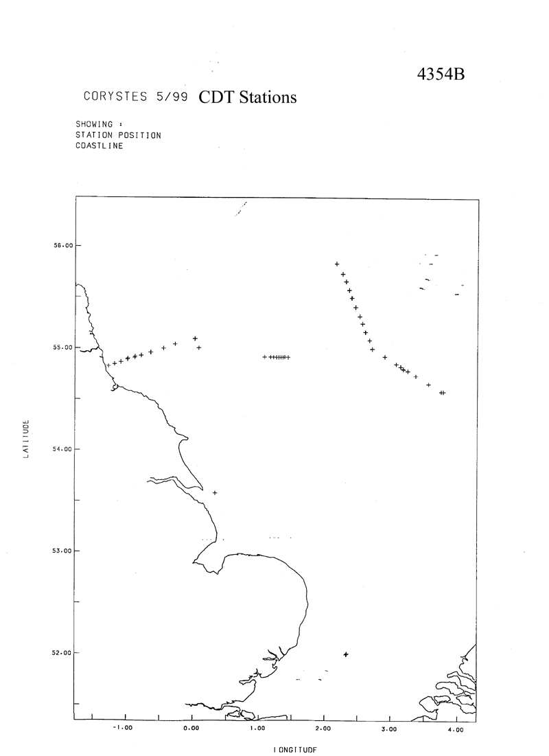
| CTD stations |
Quantity:
number of stations =
73
Description: Vertical profiles using FSI CTD with turbidity, PAR and chlorophyll sensors - some stations have data from near-surface only |
| Current profiler (eg ADCP) |
Quantity:
activity duration in days =
17
Description: Underway current profiling using RDI ADCP |
| Optics (eg underwater light levels) |
Quantity:
number of stations =
73
Description: Vertical profiles using FSI CTD with turbidity, PAR and chlorophyll sensors - some stations have data from near-surface only |
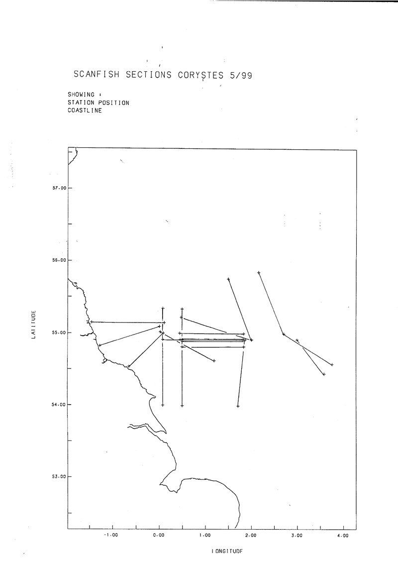
| Subsurface temperature and salinity measurements |
Quantity:
track kilometres =
1657
Description: Scanfish undulating towed body with temperature, conductivity, turbidity and fluorescence sensors |
| Surface measurements underway (T,S) |
Quantity:
activity duration in days =
17
Description: Logged hull PRT temperatures, salinity samples |
| Chemical oceanography | |
| Ammonia |
Quantity:
number of samples =
127
Description: Near surface samples along scanfish sections |
| Ammonia |
Quantity:
number of stations =
73
Description: General oceanics sampler used to collect samplesduring upcasts at each CTD station. Samples for conductivity/salinity calibration of CTD, plus nitrites, nitrates, silicates, ammonium, phosphate, suspended particulate matter, chlorophyll and phaeopigment. Samples for analyses of selected metals and particle size analyses at some stations. |
| Nitrate |
Quantity:
number of samples =
127
Description: Near surface samples along scanfish sections |
| Nitrite |
Quantity:
number of samples =
127
Description: Near surface samples along scanfish sections |
| Nitrite |
Quantity:
number of stations =
73
Description: General oceanics sampler used to collect samplesduring upcasts at each CTD station. Samples for conductivity/salinity calibration of CTD, plus nitrites, nitrates, silicates, ammonium, phosphate, suspended particulate matter, chlorophyll and phaeopigment. Samples for analyses of selected metals and particle size analyses at some stations. |
| Phosphate |
Quantity:
number of samples =
127
Description: Near surface samples along scanfish sections |
| Silicate |
Quantity:
number of samples =
127
Description: Near surface samples along scanfish sections |
| Silicate |
Quantity:
number of stations =
73
Description: General oceanics sampler used to collect samplesduring upcasts at each CTD station. Samples for conductivity/salinity calibration of CTD, plus nitrites, nitrates, silicates, ammonium, phosphate, suspended particulate matter, chlorophyll and phaeopigment. Samples for analyses of selected metals and particle size analyses at some stations. |
| Contamination | |
| Suspended matter |
Quantity:
number of stations =
73
Description: Vertical profiles using FSI CTD with turbidity, PAR and chlorophyll sensors - some stations have data from near-surface only |
| Suspended matter |
Quantity:
track kilometres =
1657
Description: Scanfish undulating towed body with temperature, conductivity, turbidity and fluorescence sensors |
| Suspended matter |
Quantity:
number of stations =
73
Description: General oceanics sampler used to collect samplesduring upcasts at each CTD station. Samples for conductivity/salinity calibration of CTD, plus nitrites, nitrates, silicates, ammonium, phosphate, suspended particulate matter, chlorophyll and phaeopigment. Samples for analyses of selected metals and particle size analyses at some stations. |
| Biology and fisheries | |
| Phytoplankton pigs (eg chlorophyll, fluorescence) |
Quantity:
number of stations =
73
Description: Vertical profiles using FSI CTD with turbidity, PAR and chlorophyll sensors - some stations have data from near-surface only |
| Phytoplankton pigs (eg chlorophyll, fluorescence) |
Quantity:
track kilometres =
1657
Description: Scanfish undulating towed body with temperature, conductivity, turbidity and fluorescence sensors |
| Phytoplankton pigs (eg chlorophyll, fluorescence) |
Quantity:
number of stations =
73
Description: General oceanics sampler used to collect samplesduring upcasts at each CTD station. Samples for conductivity/salinity calibration of CTD, plus nitrites, nitrates, silicates, ammonium, phosphate, suspended particulate matter, chlorophyll and phaeopigment. Samples for analyses of selected metals and particle size analyses at some stations. |
| Geology and geophysics | |
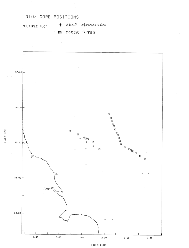
| Core - soft bottom |
Quantity:
number of cores =
26
Description: Soft bottom cores |
Cruise Inventory Mooring/Buoy Operations
| Latitude | Longitude | Data type | Description |
|---|---|---|---|
| 54° 51' N | 1° 10' E | Current profiler (eg ADCP) | Bottom mounted ADCPs deployed 15-16 June 1999 - planned recovery July 1999 |
| 54° 49' N | 0° 40' E | Current profiler (eg ADCP) | Bottom mounted ADCPs deployed 15-16 June 1999 - planned recovery July 1999 |
| 54° 55' N | 1° 30' E | Current profiler (eg ADCP) | Bottom mounted ADCPs deployed 15-16 June 1999 - planned recovery July 1999 |
| 55° 1' N | 1° 12' E | Current profiler (eg ADCP) | Bottom mounted ADCPs deployed 15-16 June 1999 - planned recovery July 1999 |
| 55° 7' N | 0° 55' E | Current profiler (eg ADCP) | Bottom mounted ADCPs deployed 15-16 June 1999 - planned recovery July 1999 |
| 52° 0' N | 2° 19' E | Nitrate | Single mooring recovered with pressure, temperature, conductivity, chlorophyll, turbidity and photosynthetically active radiation sensors - mooring was deployed May 1999 - sensors within upper 2m |
| 52° 0' N | 2° 19' E | Optics (eg underwater light levels) | Single mooring recovered with pressure, temperature, conductivity, chlorophyll, turbidity and photosynthetically active radiation sensors - mooring was deployed May 1999 - sensors within upper 2m |
| 52° 0' N | 2° 19' E | Phytoplankton pigs (eg chlorophyll, fluorescence) | Single mooring recovered with pressure, temperature, conductivity, chlorophyll, turbidity and photosynthetically active radiation sensors - mooring was deployed May 1999 - sensors within upper 2m |
| 54° 49' N | 0° 4' E | Surface drifters/drifting buoys | 2 drifting buoys deployed |
| 55° 19' N | 2° 34' E | Surface drifters/drifting buoys | Drifting buoy deployed |
| 54° 42' N | 3° 9' E | Surface drifters/drifting buoys | Drifting buoy deployed |
| 54° 42' N | 2° 49' E | Surface drifters/drifting buoys | Drifting buoy deployed |
| 55° 19' N | 3° 20' E | Surface drifters/drifting buoys | Drifting buoy deployed |
| 55° 40' N | 3° 19' E | Surface drifters/drifting buoys | Drifting buoy deployed |
| 55° 40' N | 4° 0' E | Surface drifters/drifting buoys | Drifting buoy deployed |
| 55° 0' N | 4° 0' E | Surface drifters/drifting buoys | Drifting buoy deployed |
| 55° 0' N | 3° 19' E | Surface drifters/drifting buoys | Drifting buoy deployed |
| 53° 54' N | 0° 55' E | Surface drifters/drifting buoys | Drifting buoy deployed |
| 55° 40' N | 2° 34' E | Surface drifters/drifting buoys | Drifting buoy deployed |
| 54° 34' N | 0° 30' W | Surface drifters/drifting buoys | Drifting buoy deployed |
| 55° 0' N | 2° 34' E | Surface drifters/drifting buoys | Drifting buoy deployed |
| 55° 7' N | 0° 5' E | Surface drifters/drifting buoys | Drifting buoy deployed |
| 55° 14' N | 0° 30' E | Surface drifters/drifting buoys | Drifting buoy deployed |
| 55° 19' N | 4° 0' E | Surface drifters/drifting buoys | Drifting buoy deployed |
| 55° 7' N | 0° 58' E | Surface drifters/drifting buoys | Drifting buoy deployed |
| 55° 4' N | 1° 10' E | Surface drifters/drifting buoys | Drifting buoy deployed |
| 55° 34' N | 0° 5' E | Surface drifters/drifting buoys | Drifting buoy deployed |
| 54° 20' N | 0° 4' E | Surface drifters/drifting buoys | Drifting buoy deployed |
| 54° 55' N | 1° 6' W | Surface drifters/drifting buoys | Drifting buoy deployed |
| 55° 34' N | 0° 4' E | Surface drifters/drifting buoys | Drifting buoy deployed |
| 52° 0' N | 2° 19' E | Suspended matter | Single mooring recovered with pressure, temperature, conductivity, chlorophyll, turbidity and photosynthetically active radiation sensors - mooring was deployed May 1999 - sensors within upper 2m |
Summary of BODC Data Holdings for the Cruise
National Oceanographic Database
Summary
| # Series | Instrument Description | Parameters |
|---|---|---|
| 53 | CTD/STD cast |
Chlorophyll pigment concentrations in water bodies Concentration of suspended particulate material in the water column Raw fluorometer output Salinity of the water column Temperature of the water column Vertical spatial coordinates Visible waveband radiance and irradiance measurements in the water column |
| 1 | CTD/STD cast |
Chlorophyll pigment concentrations in water bodies Raw fluorometer output Salinity of the water column Temperature of the water column Vertical spatial coordinates Visible waveband radiance and irradiance measurements in the water column |
Note: Parameter terms are taken from the BODC Parameter Discovery Vocabulary XML (SKOS)
Full List
| BODC Reference | Instrument Description | Date/Time | Location | |
|---|---|---|---|---|
| 594693 | CTD/STD cast | 1999-06-14 15:19Z | 52° 0' N, 2° 20' E | Click for more |
| 594700 | CTD/STD cast | 1999-06-14 19:02Z | 52° 0' N, 2° 19' E | Click for more |
| 594712 | CTD/STD cast | 1999-06-14 21:04Z | 52° 0' N, 2° 19' E | Click for more |
| 594724 | CTD/STD cast | 1999-06-14 21:49Z | 52° 0' N, 2° 19' E | Click for more |
| 594736 | CTD/STD cast | 1999-06-14 22:28Z | 52° 0' N, 2° 19' E | Click for more |
| 594748 | CTD/STD cast | 1999-06-15 18:06Z | 53° 34' N, 0° 19' E | Click for more |
| 594761 | CTD/STD cast | 1999-06-17 17:34Z | 55° 0' N, 0° 4' E | Click for more |
| 594773 | CTD/STD cast | 1999-06-19 01:50Z | 55° 5' N, 0° 1' E | Click for more |
| 594785 | CTD/STD cast | 1999-06-19 02:31Z | 55° 6' N, 0° 1' E | Click for more |
| 594797 | CTD/STD cast | 1999-06-19 04:14Z | 55° 2' N, 0° 16' W | Click for more |
| 594804 | CTD/STD cast | 1999-06-19 06:19Z | 55° 0' N, 0° 26' W | Click for more |
| 594816 | CTD/STD cast | 1999-06-19 06:56Z | 55° 0' N, 0° 26' W | Click for more |
| 594828 | CTD/STD cast | 1999-06-19 08:59Z | 54° 57' N, 0° 38' W | Click for more |
| 594841 | CTD/STD cast | 1999-06-19 10:40Z | 54° 55' N, 0° 46' W | Click for more |
| 594853 | CTD/STD cast | 1999-06-19 12:27Z | 54° 55' N, 0° 52' W | Click for more |
| 594865 | CTD/STD cast | 1999-06-19 14:02Z | 54° 54' N, 0° 58' W | Click for more |
| 594877 | CTD/STD cast | 1999-06-19 15:42Z | 54° 52' N, 1° 4' W | Click for more |
| 594889 | CTD/STD cast | 1999-06-19 16:37Z | 54° 51' N, 1° 10' W | Click for more |
| 594890 | CTD/STD cast | 1999-06-19 17:05Z | 54° 51' N, 1° 10' W | Click for more |
| 594908 | CTD/STD cast | 1999-06-19 18:09Z | 54° 49' N, 1° 16' W | Click for more |
| 594921 | CTD/STD cast | 1999-06-19 18:41Z | 54° 49' N, 1° 16' W | Click for more |
| 594933 | CTD/STD cast | 1999-06-22 15:43Z | 54° 55' N, 1° 25' E | Click for more |
| 594945 | CTD/STD cast | 1999-06-22 16:46Z | 54° 55' N, 1° 22' E | Click for more |
| 594957 | CTD/STD cast | 1999-06-22 17:39Z | 54° 55' N, 1° 21' E | Click for more |
| 594969 | CTD/STD cast | 1999-06-22 18:31Z | 54° 55' N, 1° 19' E | Click for more |
| 594970 | CTD/STD cast | 1999-06-22 19:26Z | 54° 55' N, 1° 17' E | Click for more |
| 594982 | CTD/STD cast | 1999-06-22 20:26Z | 54° 55' N, 1° 15' E | Click for more |
| 594994 | CTD/STD cast | 1999-06-22 21:23Z | 54° 55' N, 1° 12' E | Click for more |
| 595008 | CTD/STD cast | 1999-06-22 22:14Z | 54° 55' N, 1° 10' E | Click for more |
| 595021 | CTD/STD cast | 1999-06-22 23:17Z | 54° 55' N, 1° 4' E | Click for more |
| 595033 | CTD/STD cast | 1999-06-27 08:18Z | 54° 34' N, 3° 45' E | Click for more |
| 595045 | CTD/STD cast | 1999-06-27 10:07Z | 54° 39' N, 3° 33' E | Click for more |
| 595057 | CTD/STD cast | 1999-06-27 11:43Z | 54° 44' N, 3° 22' E | Click for more |
| 595069 | CTD/STD cast | 1999-06-27 12:37Z | 54° 47' N, 3° 15' E | Click for more |
| 595070 | CTD/STD cast | 1999-06-27 13:12Z | 54° 47' N, 3° 15' E | Click for more |
| 595082 | CTD/STD cast | 1999-06-27 18:03Z | 54° 48' N, 3° 10' E | Click for more |
| 595094 | CTD/STD cast | 1999-06-27 19:28Z | 54° 49' N, 3° 8' E | Click for more |
| 595101 | CTD/STD cast | 1999-06-27 20:25Z | 54° 51' N, 3° 4' E | Click for more |
| 595113 | CTD/STD cast | 1999-06-27 21:30Z | 54° 55' N, 2° 54' E | Click for more |
| 595125 | CTD/STD cast | 1999-06-27 22:33Z | 55° 0' N, 2° 42' E | Click for more |
| 595137 | CTD/STD cast | 1999-06-28 14:46Z | 55° 4' N, 2° 40' E | Click for more |
| 595149 | CTD/STD cast | 1999-06-28 15:12Z | 55° 4' N, 2° 40' E | Click for more |
| 595150 | CTD/STD cast | 1999-06-28 16:08Z | 55° 9' N, 2° 36' E | Click for more |
| 595162 | CTD/STD cast | 1999-06-28 17:58Z | 55° 15' N, 2° 33' E | Click for more |
| 595174 | CTD/STD cast | 1999-06-28 19:54Z | 55° 18' N, 2° 31' E | Click for more |
| 595186 | CTD/STD cast | 1999-06-28 21:15Z | 55° 24' N, 2° 27' E | Click for more |
| 595198 | CTD/STD cast | 1999-06-28 22:38Z | 55° 30' N, 2° 24' E | Click for more |
| 595205 | CTD/STD cast | 1999-06-28 23:54Z | 55° 34' N, 2° 21' E | Click for more |
| 595217 | CTD/STD cast | 1999-06-29 00:27Z | 55° 34' N, 2° 21' E | Click for more |
| 595229 | CTD/STD cast | 1999-06-29 01:44Z | 55° 39' N, 2° 18' E | Click for more |
| 595230 | CTD/STD cast | 1999-06-29 02:37Z | 55° 43' N, 2° 15' E | Click for more |
| 595242 | CTD/STD cast | 1999-06-29 03:20Z | 55° 43' N, 2° 15' E | Click for more |
| 595254 | CTD/STD cast | 1999-06-29 04:32Z | 55° 49' N, 2° 9' E | Click for more |
| 595266 | CTD/STD cast | 1999-06-29 05:12Z | 55° 49' N, 2° 10' E | Click for more |
Project Database
No data currently held for this cruise in the BODC Project Database
