DML Line P
Line P is a survey section between Skerryvore and Islay (off the west coast of Scotland). The line comprises seven fixed CTD stations, which were established as part of routine monitoring work on the Scottish continental shelf by Dunstaffnage Marine Laboratory (DML). The line was occupied between the mid 1980s and mid 1990s.
Map of standard DML Line P CTD Stations
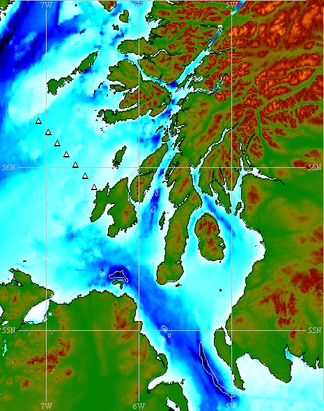
Map produced using the GEBCO Digital Atlas.
The white triangles indicate the nominal positions of each standard station on DML Line P.
Nominal station details
DML Line P: Skerryvore (Scotland) - Islay (Scotland)
| Station | Nominal latitude | Nominal longitude | Approx.
depth (m) |
Comment |
|---|---|---|---|---|
| P1 | 56° 17.0' N | 07° 05.0' W | 65 | Skerryvore |
| P2 | 56° 13.0' N | 06° 59.0' W | 75 | |
| P3 | 56° 09.0' N | 06° 53.0' W | 55 | |
| P4 | 56° 05.0' N | 06° 47.0' W | 50 | |
| P5 | 56° 01.0' N | 06° 41.0' W | 55 | |
| P6 | 55° 57.0' N | 06° 35.0' W | 50 | |
| P7 | 55° 53.0' N | 06° 29.0' W | 25 | Eil'n nam Meann (Islay) |
In addition to Line B, there are other DML repeated survey transects which converge at Islay. These are Line B , Line C , and Line D .
