Metadata Report for BODC Series Reference Number 1204676
Metadata Summary
Problem Reports
Data Access Policy
Narrative Documents
Project Information
Data Activity or Cruise Information
Fixed Station Information
BODC Quality Flags
SeaDataNet Quality Flags
Metadata Summary
Data Description |
|||||||||||||||||||||||||||||
|
|||||||||||||||||||||||||||||
Data Identifiers |
|||||||||||||||||||||||||||||
|
|||||||||||||||||||||||||||||
Time Co-ordinates(UT) |
|||||||||||||||||||||||||||||
|
|||||||||||||||||||||||||||||
Spatial Co-ordinates | |||||||||||||||||||||||||||||
|
|||||||||||||||||||||||||||||
Parameters |
|||||||||||||||||||||||||||||
|
|||||||||||||||||||||||||||||
|
|||||||||||||||||||||||||||||
Problem Reports
No Problem Report Found in the Database
Alloa Quality Report
Screening and QC
The data have had QC applied by SEPA with suspect data being removed. Data then went through BODC QC procedures.
During screening noisy periods were observed in several parameters, but these were left unflagged. M flags were applied to spikes and to slightly negative values in TURBXXXX, ODSDM021 and CPHLZZXX. In the TURBXXXX and CPHLZZXX channels there were also negative vlaues which where less than -1 NTU and -1 mg m-3 respectively that were flagged null. These values are available on request. Null values were assigned an N flag.
Prolonged periods with constant data were also considered anomalous and flagged, these can be identified for TEMPPR01 in a number of series including 1205004 and 1205028. Several series also exhibit anomalous TEMPPR01 data which were flagged (e.g. series 1204916, 1204941, 1204953, 1204965, 1204989, 1205028, 1205053, 1205065).
A period with anomalous DOXYSZZ01, PHXXZXX and PSALZZXX has been identified in series 1205201 (from 18 August 2009 12:00 hours to 21 August 2009 11:00 hours). After some investigation, it was decided not to assign any quality flags as it these data were found to be related with a meteorological event. Although readings are considered to be valid, the data should be used with caution.
For some series, TURBXXXX and CPHLZZXX exhibit some high values which might be related with particles adhering to the sensor. These instances have not been flagged.
Ship service visits were taken at a single point in time, where stated in the originator's data.
Data Access Policy
Open Data
These data have no specific confidentiality restrictions for users. However, users must acknowledge data sources as it is not ethical to publish data without proper attribution. Any publication or other output resulting from usage of the data should include an acknowledgment.
If the Information Provider does not provide a specific attribution statement, or if you are using Information from several Information Providers and multiple attributions are not practical in your product or application, you may consider using the following:
"Contains public sector information licensed under the Open Government Licence v1.0."
Narrative Documents
Hydrolabs Series 5 parameter probe
The Hydrolabs series 5 includes multi-parameter probes that allow for optimized combinations of sensors and accessories to be used in monitoring applications in different environmental sources. The available sensors provide data for temperature, depth, conductivity, salinity, specific conductance, TDS, pH, ORP, dissolved oxygen, turbidity, chlorophyll a, blue-green algae, Rhodamine WT, ammonium, nitrate, chloride, PAR and total dissolved gases.
The various models (MS5, DS5 and DS5X) operate in a similar way and the main differences relate to the number of parameters measured, MS5 measures up to 12 parameters and DS5 and DS5X can measure up to 16 parameters simultaneously.
All models can operate in a temperature ranging from 0°C to 50°C and can be deployed at depths up to 200 m.
Below is a table with the sensors specifications:
| Sensor | Range | Accuracy | Resolution |
|---|---|---|---|
| Depth | 0 to 10 m 0 to 25 m 0 to 100 m 0 to 200 m | ± 0.003 m ± 0.05 m ± 0.05 m ± 0.1 m | 0.001 m 0.01 m 0.01 m 0.1 m |
| Temperature | -5° to 50°C | ± 0.10°C | 0.01°C |
| Conductivity | 0 to 100 mS cm-1 | ±(0.5% of reading + 0.01 mS cm-1) | - |
| Salinity | 0 to 70 ppt | ± 0.2 ppt | 0.01 ppt |
| pH | 0 to 14 | ± 0.2 | 0.01 |
| Turbidity (self-cleaning) | 0 to 3000 NTU | Compared to StablCal ± 1% up to 100 NTU ± 3% from 100-400 NTU ± 5% from 400-3000 NTU | 0.1 NTU from 0-400 NTU 1 NTU for >400-3000 NTU |
| Turbidity (4 Beam) | 0 to 1000 NTU | ± (5% of reading + 1 NTU) | 0.1 NTU from 0-100 NTU 1 NTU for >100 NTU |
| Chlorophyll a | Dynamic range Low sensitivity: 0.03-500 µg l-1 Med. sensitivity: 0.03-50 µg l-1 High sensitivity: 0.03-5 µg l-1 | ± 3% using Rhodamine WT dye as a standard at >= 400 ppb | 0.01 µg l-1 |
| Hach DO | 0 to 60 mg l-1 | ± 0.1 mg l-1 @ <= 8 mg l-1 ± 0.2 mg l-1 @ > 8 mg l-1 ± 10% of reading > 20 mg l-1 | 0.01 mg l-1 |
| Polarographic DO | 0 to 50 mg l-1 | ± 0.2 mg l-1 @ <= 20 mg l-1 ± 0.6 mg l-1 @ >= 20 mg l-1 | 0.01 mg l-1 |
| Blue green algae | Dynamic range Low sensitivity: 150-2*106 cells ml-1 Med. sensitivity: 150-2*105 cells ml-1 High sensitivity: 150-2*104 cells ml-1 | ± 3% using Rhodamine WT dye as a standard at >= 400 ppb | 20 cells ml-1 |
| Rhodamine WT | Dynamic range Low sensitivity: 0.04-1000 ppb Med. sensitivity: 0.04-100 ppb High sensitivity: 0.04-10 ppb | ± 3% for 1 ppb Rhodamine WT or higher | 0.01 ppb |
| Total Dissolved Gases | 400 to 1400 mmHg | ± 1.5 mmHg | 1.0 mmHg |
| ORP | -999 to 999 mV | ± 20 mV | 1 mV |
| PAR | 0 to 10000 µmol s-1 -2 | ± 0.10°C | 1 µmol s-1 m-2 |
| Ion Selective Electrodes (max depth of 15 meters) | |||
| Ammonia | 0 to 100 mg l-1-N | > 5% of reading or ± 2 mg l-1-N | 0.01 mg l-1-N |
| Nitrate | 0 to 100 mg l-1-N | > 5% of reading or ± 2 mg l-1-N | 0.01 mg l-1-N |
| Chloride | 0.5 to 18000 mg l-1 | > 5% of reading or ± 2 mg l-1 | 4 digits |
Further information can be found in the manufacturer's data sheet.
SEPA Mooring Instrumentation
The SEPA long-term monitoring project has obtained hydrographic data across various moorings through the deployment of a YSI 6600 multi-parameter-sonde attached to a fixed mooring buoy at the surface of the water column.
These mooring sites include: Dunoon, Gunnet Ledge, Inner Clyde Estuary, Campbelltown, Loch Striven, Ythan, Loch Sunart, South Alloa, and Moray Firth.
The South Alloa site had two Hydrolab MS5 probes up until the 3rd of March 2011, at which point a YSI 6600 probe was used.
The Inner Clyde Estuary site also has a probe attached approximately 1 m from the sea floor in addition to the probe at the surface.
The Moray Firth site was monitored solely between July and December 2018.
The depth of the sensors at the time of measurement at each site is available upon request for the 2016 and 2017 data.
The turbidity sensors are deemed, by the manufacturer, to be used as guidance in events such as observing storm events or spotting discharges. SEPA rely on a suspended solids laboratory procedure for their turbidity reported data. The same situation occurs for chlorophyll, SEPA have a lab method they use to report it as high turbidity can interfere with the readings. This is not generally an issue in low turbidity areas.
BODC processing of SEPA's long-term monitoring buoys
Data Acquisition and Transfer
The data were sent by SEPA as yearly .csv files and following BODC's procedures the files were checked for consistency and subsequently archived.
The data were reformatted to QXF format using BODC's established procedures. During the transfer process each yearly file was split into cruise-to-cruise series events. The table below shows how the originator's parameters were mapped to BODC parameters and their units:
| Originator's Parameter | Originator's Units | BODC Parameter Code | BODC Units | Comments |
|---|---|---|---|---|
| Temp | deg C | TEMPPR01 | °C | |
| pH | pH Units | PHXXZZXX | pH Units | |
| Salin | ppt | ODSDM021 | ppt | |
| DO% | % Sat | OXYSZZ01 | % | For legacy data Oxygen saturation is not derived by BODC but taken from the data supplied. |
| DO | mg/l | DOXYZZ01 | µmol/l | Conversion of * 31.252 was applied during transfer (Bittig et al., 2018) |
| Turb | NTU | TURBXXXX | NTU | |
| Chl | µg/l | CPHLZZXX | mg/m3 | |
| Depth | m | PPSBPS01 | m | Depth has been transferred for 2018 onwards, and is available on request for 2016 and 2017. Depth is not available for data previous to 2016. |
Data Quality and Screening
Not all parameters occur in all series, particularly pH, turbidity and chlorophyll.
Oxygen saturation is not derived by BODC for consistency across all years and due to missing channels as mentioned in the originator's processing document.
The standard unit conversion factor of * 31.252 was applied to oxygen concentration during transfer to obtain the BODC units of µmol/l. (Bittig et al., 2018)
Post transfer analysis and crosschecks were applied according to BODC procedures. This involved the screening of data to check flags were appropriately applied whilst also applying further quality control flags where appropriate. Originator flags for "No sensor; Quality Control failure; Quality Control Spike Removed; Quality Control Spike removed, wiper incorrectly parking over sensor; Power Failure, Sensor failure" were all flagged as 'Null' as no data were available when these were applied.
References
Bittig, H., Körtzinger, A., Johnson, K., Claustre, H., Emerson, S., Fennel, K., ... & Xing, X. 2018. SCOR WG 142: Quality Control Procedures for Oxygen and Other Biogeochemical Sensors on Floats and Gliders. Recommendations on the conversion between oxygen quantities for Bio-Argo floats and other autonomous sensor platforms.
SEPA originator's processing document for Alloa long-term monitoring buoy
Data Acquisition and Analysis
Data were obtained from a probe attached to a mooring deployed in Firth of Forth, off Alloa. The mooring was serviced and deployed by the Scottish Environment Protection Agency (SEPA) for the purpose of long-term monitoring. Up to 3 March 2011, a Hydrolabs probe was used and subsequently replaced by a YSI 6600 probe.
The raw data were downloaded directly from the instruments, occasional problems during the remote downloading of data meant that sometimes strings were overwritten, leading to one parameter being downloaded at the expense of another. So although all parameters were measured, not all were included in the originator's files. Data were downloaded in local time and following discussion with BODC they were then corrected to GMT before being submitted.
Quality and Screening
Once downloaded the data went through SEPA data quality checks with suspect data removed and relevant flags attached to inform future users of the reason for any missing data. This information is available upon request.
Submission
The data were then submitted to BODC through ftp as yearly .csv files.
Project Information
No Project Information held for the Series
Data Activity or Cruise Information
Cruise
| Cruise Name | Mi19980609 |
| Departure Date | 1998-06-09 |
| Arrival Date | 1998-06-09 |
| Principal Scientist(s) | Matthew V Blackburn (Scottish Environment Protection Agency, Edinburgh) |
| Ship | Unknown self-propelled small boat |
Complete Cruise Metadata Report is available here
Fixed Station Information
Fixed Station Information
| Station Name | SEPA_Alloa |
| Category | Coastal location |
| Latitude | 56° 6.17' N |
| Longitude | 3° 48.59' W |
| Water depth below MSL | 5.0 m |
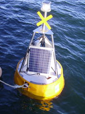
SEPA South Alloa Fixed Station Mooring
| Location Name | Alloa |
|---|---|
| Nominal Latitude (+ve N) | 56.10285 |
| Nominal Longitude (+ve E) | -3.80988 |
| Water depth | 5 m |
| Period of data collection | Initiated in 1988 |
The buoy is located in the upper Forth estuary, near Alloa, and provides measurements of dissolved oxygen, salinity, temperature, pH, chlorophyll and turbidity. Its maintenance is done on a monthly basis using one of SEPA's support vessels and is done in such a way as to prevent loss of information, for more recent records, this includes a change in the probe that is installed in the buoy, thus making readings continuous through time.
Up until July 2010, the sampling interval was set to collect a measurement every 15 minutes. From then until July 2014, a measurement was collected every 30 minutes. From this point, a sample was collected every 15 minutes. This buoy has also seen a change in the measurement probes, up to 3 March 2011, the measurements were collected with a Hydrolab Ms5, which was subsequently replaced by a YSI 6600 probe.
More information may be found at the SEPA monitoring buoy network page for Alloa.
Related Fixed Station activities are detailed in Appendix 1
BODC Quality Control Flags
The following single character qualifying flags may be associated with one or more individual parameters with a data cycle:
| Flag | Description |
|---|---|
| Blank | Unqualified |
| < | Below detection limit |
| > | In excess of quoted value |
| A | Taxonomic flag for affinis (aff.) |
| B | Beginning of CTD Down/Up Cast |
| C | Taxonomic flag for confer (cf.) |
| D | Thermometric depth |
| E | End of CTD Down/Up Cast |
| G | Non-taxonomic biological characteristic uncertainty |
| H | Extrapolated value |
| I | Taxonomic flag for single species (sp.) |
| K | Improbable value - unknown quality control source |
| L | Improbable value - originator's quality control |
| M | Improbable value - BODC quality control |
| N | Null value |
| O | Improbable value - user quality control |
| P | Trace/calm |
| Q | Indeterminate |
| R | Replacement value |
| S | Estimated value |
| T | Interpolated value |
| U | Uncalibrated |
| W | Control value |
| X | Excessive difference |
SeaDataNet Quality Control Flags
The following single character qualifying flags may be associated with one or more individual parameters with a data cycle:
| Flag | Description |
|---|---|
| 0 | no quality control |
| 1 | good value |
| 2 | probably good value |
| 3 | probably bad value |
| 4 | bad value |
| 5 | changed value |
| 6 | value below detection |
| 7 | value in excess |
| 8 | interpolated value |
| 9 | missing value |
| A | value phenomenon uncertain |
| B | nominal value |
| Q | value below limit of quantification |
Appendix 1: SEPA_Alloa
Related series for this Fixed Station are presented in the table below. Further information can be found by following the appropriate links.
If you are interested in these series, please be aware we offer a multiple file download service. Should your credentials be insufficient for automatic download, the service also offers a referral to our Enquiries Officer who may be able to negotiate access.
| Series Identifier | Data Category | Start date/time | Start position | Cruise |
|---|---|---|---|---|
| 1204547 | Hydrography time series at depth | 1996-04-30 12:45:00 | 56.10285 N, 3.80987 W | Unknown self-propelled small boat Mi19960430 |
| 1204559 | Hydrography time series at depth | 1996-05-29 13:00:00 | 56.10285 N, 3.80987 W | Unknown self-propelled small boat Mi19960529 |
| 1204560 | Hydrography time series at depth | 1996-06-17 16:30:00 | 56.10285 N, 3.80987 W | Unknown self-propelled small boat Mi19960617 |
| 1204572 | Hydrography time series at depth | 1996-07-10 11:30:00 | 56.10285 N, 3.80987 W | Unknown self-propelled small boat Mi19960710 |
| 1204584 | Hydrography time series at depth | 1996-08-07 09:30:00 | 56.10285 N, 3.80987 W | Unknown self-propelled small boat Mi19960807 |
| 1204596 | Hydrography time series at depth | 1996-09-09 14:30:00 | 56.10285 N, 3.80987 W | Unknown self-propelled small boat Mi19960909 |
| 1204603 | Hydrography time series at depth | 1997-04-08 17:15:00 | 56.10285 N, 3.80987 W | Unknown self-propelled small boat Mi19970408 |
| 1204615 | Hydrography time series at depth | 1997-04-16 14:30:00 | 56.10285 N, 3.80987 W | Unknown self-propelled small boat Mi19970416 |
| 1204639 | Hydrography time series at depth | 1997-05-14 23:00:00 | 56.10285 N, 3.80987 W | Unknown self-propelled small boat Mi19970514 |
| 1204640 | Hydrography time series at depth | 1997-06-20 16:00:00 | 56.10285 N, 3.80987 W | Unknown self-propelled small boat Mi19970620 |
| 1204652 | Hydrography time series at depth | 1997-09-17 16:30:00 | 56.10285 N, 3.80987 W | Unknown self-propelled small boat Mi19970917 |
| 1204664 | Hydrography time series at depth | 1998-04-07 11:30:00 | 56.10285 N, 3.80987 W | Unknown self-propelled small boat Mi19980407 |
| 1204688 | Hydrography time series at depth | 1998-07-02 09:30:00 | 56.10285 N, 3.80987 W | Unknown self-propelled small boat Mi19980702 |
| 1204707 | Hydrography time series at depth | 1998-08-18 12:45:00 | 56.10285 N, 3.80987 W | Unknown self-propelled small boat Mi19980818 |
| 1204719 | Hydrography time series at depth | 1999-06-22 23:00:00 | 56.10285 N, 3.80987 W | Unknown self-propelled small boat Mi19990622 |
| 1204720 | Hydrography time series at depth | 2000-03-30 09:15:00 | 56.10285 N, 3.80987 W | Unknown self-propelled small boat Mi20000330 |
| 1204732 | Hydrography time series at depth | 2000-06-19 15:30:00 | 56.10285 N, 3.80987 W | Unknown self-propelled small boat Mi20000619 |
| 1204744 | Hydrography time series at depth | 2000-07-11 12:45:00 | 56.10285 N, 3.80987 W | Unknown self-propelled small boat Mi20000711 |
| 1204756 | Hydrography time series at depth | 2000-08-30 15:30:00 | 56.10285 N, 3.80987 W | Unknown self-propelled small boat Mi20000830 |
| 1204768 | Hydrography time series at depth | 2001-04-03 10:15:00 | 56.10285 N, 3.80987 W | Unknown self-propelled small boat Mi20010403 |
| 1204781 | Hydrography time series at depth | 2002-03-26 11:30:00 | 56.10285 N, 3.80987 W | Unknown self-propelled small boat Mi20020326 |
| 1204793 | Hydrography time series at depth | 2002-04-30 15:45:00 | 56.10285 N, 3.80987 W | Unknown self-propelled small boat Mi20020430 |
| 1204800 | Hydrography time series at depth | 2002-06-24 14:15:00 | 56.10285 N, 3.80987 W | Unknown self-propelled small boat Mi20020624 |
| 1204812 | Hydrography time series at depth | 2002-08-02 14:00:00 | 56.10285 N, 3.80987 W | Unknown self-propelled small boat Mi20020802 |
| 1204824 | Hydrography time series at depth | 2002-08-19 22:45:00 | 56.10285 N, 3.80987 W | Unknown self-propelled small boat Mi20020819 |
| 1204836 | Hydrography time series at depth | 2002-09-09 00:00:00 | 56.10285 N, 3.80987 W | Unknown self-propelled small boat Mi20020909 |
| 1204848 | Hydrography time series at depth | 2003-05-16 23:15:00 | 56.10285 N, 3.80987 W | Unknown self-propelled small boat Mi20030516 |
| 1204861 | Hydrography time series at depth | 2003-07-15 23:00:00 | 56.10285 N, 3.80987 W | Unknown self-propelled small boat Mi20030715 |
| 1204873 | Hydrography time series at depth | 2003-09-24 00:00:00 | 56.10285 N, 3.80987 W | Unknown self-propelled small boat Mi20030923 |
| 1204885 | Hydrography time series at depth | 2004-05-31 23:15:00 | 56.10285 N, 3.80987 W | Unknown self-propelled small boat Mi20040531 |
| 1204897 | Hydrography time series at depth | 2004-09-06 09:00:00 | 56.10285 N, 3.80987 W | Unknown self-propelled small boat Mi20040906 |
| 1204904 | Hydrography time series at depth | 2005-03-23 12:45:00 | 56.10285 N, 3.80987 W | Unknown self-propelled small boat Mi20050323 |
| 1204916 | Hydrography time series at depth | 2005-05-23 13:45:00 | 56.10285 N, 3.80987 W | Unknown self-propelled small boat Mi20050523 |
| 1204928 | Hydrography time series at depth | 2005-08-16 08:30:00 | 56.10285 N, 3.80987 W | Unknown self-propelled small boat Mi20050816 |
| 1204941 | Hydrography time series at depth | 2006-03-29 13:45:00 | 56.10285 N, 3.80987 W | Unknown self-propelled small boat Mi20060329 |
| 1204953 | Hydrography time series at depth | 2006-06-09 12:45:00 | 56.10285 N, 3.80987 W | Unknown self-propelled small boat Mi20060609 |
| 1204965 | Hydrography time series at depth | 2006-07-07 11:45:00 | 56.10285 N, 3.80987 W | Unknown self-propelled small boat Mi20060707 |
| 1204977 | Hydrography time series at depth | 2006-09-18 11:30:00 | 56.10285 N, 3.80987 W | Unknown self-propelled small boat Mi20060918 |
| 1204989 | Hydrography time series at depth | 2007-04-13 07:45:00 | 56.10285 N, 3.80987 W | Unknown self-propelled small boat Mi20070413 |
| 1204990 | Hydrography time series at depth | 2007-06-13 11:45:00 | 56.10285 N, 3.80987 W | Unknown self-propelled small boat Mi20070613 |
| 1205004 | Hydrography time series at depth | 2007-08-01 14:45:00 | 56.10285 N, 3.80987 W | Unknown self-propelled small boat Mi20070801 |
| 1205016 | Hydrography time series at depth | 2007-08-29 13:15:00 | 56.10285 N, 3.80987 W | Unknown self-propelled small boat Mi20070829 |
| 1205028 | Hydrography time series at depth | 2008-01-21 11:30:00 | 56.10285 N, 3.80987 W | Unknown self-propelled small boat Mi20080121 |
| 1205041 | Hydrography time series at depth | 2008-03-06 11:00:00 | 56.10285 N, 3.80987 W | Unknown self-propelled small boat Mi20080306 |
| 1205053 | Hydrography time series at depth | 2008-03-17 12:00:00 | 56.10285 N, 3.80987 W | Unknown self-propelled small boat Mi20080317 |
| 1205065 | Hydrography time series at depth | 2008-05-06 07:15:00 | 56.10285 N, 3.80987 W | Unknown self-propelled small boat Mi20080506 |
| 1205077 | Hydrography time series at depth | 2008-06-19 16:30:00 | 56.10285 N, 3.80987 W | Unknown self-propelled small boat Mi20080619 |
| 1205089 | Hydrography time series at depth | 2008-07-16 14:45:00 | 56.10285 N, 3.80987 W | Unknown self-propelled small boat Mi20080716 |
| 1205090 | Hydrography time series at depth | 2008-09-02 13:30:00 | 56.10285 N, 3.80987 W | Unknown self-propelled small boat Mi20080902 |
| 1205108 | Hydrography time series at depth | 2008-10-27 13:30:00 | 56.10285 N, 3.80987 W | Unknown self-propelled small boat Mi20081027 |
| 1205121 | Hydrography time series at depth | 2008-12-11 12:15:00 | 56.10285 N, 3.80987 W | Unknown self-propelled small boat Mi20081211 |
| 1205133 | Hydrography time series at depth | 2009-01-01 00:00:00 | 56.10285 N, 3.80987 W | Unknown self-propelled small boat Mi20081211 |
| 1205145 | Hydrography time series at depth | 2009-01-14 14:45:00 | 56.10285 N, 3.80987 W | Unknown self-propelled small boat Mi20090114 |
| 1205157 | Hydrography time series at depth | 2009-03-26 12:15:00 | 56.10285 N, 3.80987 W | Unknown self-propelled small boat Mi20090326 |
| 1205169 | Hydrography time series at depth | 2009-04-25 11:00:00 | 56.10285 N, 3.80987 W | Unknown self-propelled small boat Mi20090425 |
| 1205170 | Hydrography time series at depth | 2009-05-19 08:15:00 | 56.10285 N, 3.80987 W | Unknown self-propelled small boat Mi20090519 |
| 1205182 | Hydrography time series at depth | 2009-06-27 11:00:00 | 56.10285 N, 3.80987 W | Unknown self-propelled small boat Mi20090627 |
| 1205194 | Hydrography time series at depth | 2009-07-22 14:15:00 | 56.10285 N, 3.80987 W | Unknown self-propelled small boat Mi20090722 |
| 1205201 | Hydrography time series at depth | 2009-08-18 12:00:00 | 56.10285 N, 3.80987 W | Unknown self-propelled small boat Mi20090818 |
| 1205213 | Hydrography time series at depth | 2009-09-17 12:00:00 | 56.10285 N, 3.80987 W | Unknown self-propelled small boat Mi20090917 |
| 1205225 | Hydrography time series at depth | 2009-10-16 02:00:00 | 56.10285 N, 3.80987 W | Unknown self-propelled small boat Mi20091016 |
| 1205237 | Hydrography time series at depth | 2009-11-10 11:00:00 | 56.10285 N, 3.80987 W | Unknown self-propelled small boat Mi20091110 |
| 1205249 | Hydrography time series at depth | 2010-02-15 14:30:00 | 56.10285 N, 3.80987 W | Unknown self-propelled small boat Mi20100215 |
| 1205250 | Hydrography time series at depth | 2010-03-25 10:15:00 | 56.10285 N, 3.80987 W | Unknown self-propelled small boat Mi20100325 |
| 1205262 | Hydrography time series at depth | 2010-04-08 12:15:00 | 56.10285 N, 3.80987 W | Unknown self-propelled small boat Mi20100408 |
| 1205274 | Hydrography time series at depth | 2010-05-13 11:30:00 | 56.10285 N, 3.80987 W | Unknown self-propelled small boat Mi20100513 |
| 1205286 | Hydrography time series at depth | 2010-06-24 11:45:00 | 56.10285 N, 3.80987 W | Unknown self-propelled small boat Mi20100624 |
| 1205298 | Hydrography time series at depth | 2010-07-13 13:30:00 | 56.10285 N, 3.80987 W | Unknown self-propelled small boat Mi20100713 |
| 1205305 | Hydrography time series at depth | 2010-08-10 12:00:00 | 56.10285 N, 3.80987 W | Unknown self-propelled small boat Kelpie20100810 |
| 1205317 | Hydrography time series at depth | 2010-09-18 11:30:00 | 56.10285 N, 3.80987 W | Unknown self-propelled small boat Kelpie20100918 |
| 1205329 | Hydrography time series at depth | 2010-10-20 12:00:00 | 56.10285 N, 3.80987 W | Unknown self-propelled small boat Kelpie20101020 |
| 1205330 | Hydrography time series at depth | 2010-11-20 13:30:00 | 56.10285 N, 3.80987 W | Unknown self-propelled small boat Kelpie20101120 |
| 1205342 | Hydrography time series at depth | 2010-12-15 13:30:00 | 56.10285 N, 3.80987 W | Unknown self-propelled small boat Kelpie20101215 |
| 1205354 | Hydrography time series at depth | 2011-01-01 00:00:00 | 56.10285 N, 3.80987 W | Unknown self-propelled small boat Kelpie20101215 |
| 1205366 | Hydrography time series at depth | 2011-01-07 12:30:00 | 56.10285 N, 3.80987 W | Unknown self-propelled small boat Kelpie20110107 |
| 1205378 | Hydrography time series at depth | 2011-02-15 11:30:00 | 56.10285 N, 3.80987 W | Unknown self-propelled small boat Kelpie20110215 |
| 1205391 | Hydrography time series at depth | 2011-03-03 13:00:00 | 56.10285 N, 3.80987 W | Unknown self-propelled small boat Kelpie20110303 |
| 1205409 | Hydrography time series at depth | 2011-04-04 12:30:00 | 56.10285 N, 3.80987 W | Unknown self-propelled small boat Kelpie20110404 |
| 1205410 | Hydrography time series at depth | 2011-05-27 10:00:00 | 56.10285 N, 3.80987 W | Unknown self-propelled small boat Kelpie20110527 |
| 1205422 | Hydrography time series at depth | 2011-06-13 11:00:00 | 56.10285 N, 3.80987 W | Unknown self-propelled small boat Kelpie20110613 |
| 1205434 | Hydrography time series at depth | 2011-07-13 12:00:00 | 56.10285 N, 3.80987 W | Unknown self-propelled small boat Kelpie20110713 |
| 1205446 | Hydrography time series at depth | 2011-08-09 12:30:00 | 56.10285 N, 3.80987 W | Unknown self-propelled small boat Kelpie20110809 |
| 1205458 | Hydrography time series at depth | 2011-09-26 12:00:00 | 56.10285 N, 3.80987 W | Unknown self-propelled small boat Kelpie20110926 |
| 1205471 | Hydrography time series at depth | 2011-10-10 08:30:00 | 56.10285 N, 3.80987 W | Unknown self-propelled small boat Kelpie20111010 |
| 1205483 | Hydrography time series at depth | 2011-11-22 11:30:00 | 56.10285 N, 3.80987 W | Unknown self-propelled small boat Kelpie20111122 |
| 1205495 | Hydrography time series at depth | 2012-01-01 00:00:00 | 56.10285 N, 3.80987 W | Unknown self-propelled small boat Kelpie20111122 |
| 1205502 | Hydrography time series at depth | 2012-01-09 14:00:00 | 56.10285 N, 3.80987 W | Unknown self-propelled small boat Kelpie20120109 |
| 1205514 | Hydrography time series at depth | 2012-02-10 14:00:00 | 56.10285 N, 3.80987 W | Unknown self-propelled small boat Kelpie20120210 |
| 1205526 | Hydrography time series at depth | 2012-03-04 11:30:00 | 56.10285 N, 3.80987 W | Unknown self-propelled small boat Kelpie20120304 |
| 1205538 | Hydrography time series at depth | 2012-05-21 13:00:00 | 56.10285 N, 3.80987 W | Unknown self-propelled small boat Kelpie20120521 |
| 1205551 | Hydrography time series at depth | 2012-06-04 13:00:00 | 56.10285 N, 3.80987 W | Unknown self-propelled small boat Kelpie20120604 |
| 1205563 | Hydrography time series at depth | 2012-07-03 13:30:00 | 56.10285 N, 3.80987 W | Unknown self-propelled small boat Kelpie20120703 |
| 1205575 | Hydrography time series at depth | 2012-08-01 13:30:00 | 56.10285 N, 3.80987 W | Unknown self-propelled small boat Kelpie20120801 |
| 1205587 | Hydrography time series at depth | 2012-09-03 12:00:00 | 56.10285 N, 3.80987 W | Unknown self-propelled small boat Kelpie20120903 |
| 1205599 | Hydrography time series at depth | 2012-10-30 13:30:00 | 56.10285 N, 3.80987 W | Unknown self-propelled small boat Kelpie20121030 |
| 1205606 | Hydrography time series at depth | 2012-11-10 14:00:00 | 56.10285 N, 3.80987 W | Unknown self-propelled small boat Kelpie20121110 |
| 1205618 | Hydrography time series at depth | 2012-12-13 14:01:00 | 56.10285 N, 3.80987 W | Unknown self-propelled small boat Kelpie20121213 |
| 1778226 | Hydrography time series at depth | 2013-01-01 00:01:00 | 56.10285 N, 3.80987 W | Unknown self-propelled small boat Kelpie20121213 |
| 1778238 | Hydrography time series at depth | 2013-01-24 12:31:00 | 56.10285 N, 3.80987 W | Kelpie Kelpie20130124 |
| 1778251 | Hydrography time series at depth | 2013-02-11 14:31:00 | 56.10285 N, 3.80987 W | Kelpie Kelpie20130211 |
| 1778263 | Hydrography time series at depth | 2013-03-08 10:31:00 | 56.10285 N, 3.80987 W | Kelpie Kelpie20130308 |
| 1778275 | Hydrography time series at depth | 2013-04-09 13:01:00 | 56.10285 N, 3.80987 W | Kelpie Kelpie20130409 |
| 1778287 | Hydrography time series at depth | 2013-05-24 13:00:00 | 56.10285 N, 3.80987 W | Kelpie Kelpie20130524 |
| 1778299 | Hydrography time series at depth | 2013-06-20 09:30:00 | 56.10285 N, 3.80987 W | Kelpie Kelpie20130620 |
| 1778306 | Hydrography time series at depth | 2013-07-08 11:30:00 | 56.10285 N, 3.80987 W | Kelpie Kelpie20130708 |
| 1778318 | Hydrography time series at depth | 2013-08-07 13:30:00 | 56.10285 N, 3.80987 W | Kelpie Kelpie20130807 |
| 1778331 | Hydrography time series at depth | 2013-09-03 12:00:00 | 56.10285 N, 3.80987 W | Kelpie Kelpie20130903 |
| 1778343 | Hydrography time series at depth | 2013-10-16 11:30:00 | 56.10285 N, 3.80987 W | Kelpie Kelpie20131016 |
| 1778355 | Hydrography time series at depth | 2013-11-14 12:01:00 | 56.10285 N, 3.80987 W | Kelpie Kelpie20131114 |
| 1778367 | Hydrography time series at depth | 2013-12-03 14:01:00 | 56.10285 N, 3.80987 W | Kelpie Kelpie20131203 |
| 1374085 | Hydrography time series at depth | 2014-01-15 13:31:00 | 56.10285 N, 3.80987 W | Kelpie Kelpie20140115 |
| 1374097 | Hydrography time series at depth | 2014-02-28 12:00:00 | 56.10285 N, 3.80987 W | Kelpie Kelpie20140227 |
| 1374104 | Hydrography time series at depth | 2014-03-14 11:00:00 | 56.10285 N, 3.80987 W | Kelpie Kelpie20140314 |
| 1374116 | Hydrography time series at depth | 2014-04-28 11:00:00 | 56.10285 N, 3.80987 W | Kelpie Kelpie20140428 |
| 1374128 | Hydrography time series at depth | 2014-06-26 13:30:00 | 56.10285 N, 3.80987 W | Kelpie Kelpie20140626 |
| 1374141 | Hydrography time series at depth | 2014-07-14 15:01:00 | 56.10285 N, 3.80987 W | Kelpie Kelpie20140714 |
| 1374153 | Hydrography time series at depth | 2014-08-26 10:45:00 | 56.10285 N, 3.80987 W | Kelpie Kelpie20140826 |
| 1374165 | Hydrography time series at depth | 2014-10-07 12:00:00 | 56.10285 N, 3.80987 W | Kelpie Kelpie20141007 |
| 1374177 | Hydrography time series at depth | 2014-11-04 11:46:00 | 56.10285 N, 3.80987 W | Kelpie Kelpie20141104 |
| 1374189 | Hydrography time series at depth | 2014-12-04 11:16:00 | 56.10285 N, 3.80987 W | Kelpie Kelpie20140412 |
| 1774305 | Hydrography time series at depth | 2015-01-01 00:01:00 | 56.10285 N, 3.80987 W | Kelpie Kelpie20140412 |
| 1774317 | Hydrography time series at depth | 2015-03-19 11:46:00 | 56.10285 N, 3.80987 W | Kelpie Kelpie20150319 |
| 1774329 | Hydrography time series at depth | 2015-04-16 11:31:00 | 56.10285 N, 3.80987 W | Kelpie Kelpie20150416 |
| 1774330 | Hydrography time series at depth | 2015-05-18 13:31:00 | 56.10285 N, 3.80987 W | Kelpie Kelpie20150518 |
| 1774342 | Hydrography time series at depth | 2015-06-01 12:16:00 | 56.10285 N, 3.80987 W | Kelpie Kelpie20150601 |
| 1774354 | Hydrography time series at depth | 2015-07-28 10:46:00 | 56.10285 N, 3.80987 W | Kelpie Kelpie20150728 |
| 1774366 | Hydrography time series at depth | 2015-08-27 11:16:00 | 56.10285 N, 3.80987 W | Kelpie Kelpie20150827 |
| 1774378 | Hydrography time series at depth | 2015-09-14 14:30:00 | 56.10285 N, 3.80987 W | Kelpie Kelpie20150914 |
| 1774391 | Hydrography time series at depth | 2015-10-12 13:00:00 | 56.10285 N, 3.80987 W | Kelpie Kelpie20151012 |
| 1774409 | Hydrography time series at depth | 2015-11-11 13:16:00 | 56.10285 N, 3.80987 W | Kelpie Kelpie20151111 |
| 1774410 | Hydrography time series at depth | 2015-12-14 14:16:00 | 56.10285 N, 3.80987 W | Kelpie Kelpie20151214 |
| 1805127 | Hydrography time series at depth | 2016-01-01 00:00:00 | 56.10285 N, 3.80988 W | Kelpie Kelpie20151214 |
| 1805139 | Hydrography time series at depth | 2016-01-21 12:00:00 | 56.10285 N, 3.80988 W | Kelpie Kelpie20160121 |
| 1805140 | Hydrography time series at depth | 2016-02-08 12:45:00 | 56.10285 N, 3.80988 W | Kelpie Kelpie20160208 |
| 1805152 | Hydrography time series at depth | 2016-03-07 11:15:00 | 56.10285 N, 3.80988 W | Kelpie Kelpie20160307 |
| 1805164 | Hydrography time series at depth | 2016-04-05 10:45:00 | 56.10285 N, 3.80988 W | Kelpie Kelpie20160405 |
| 1805176 | Hydrography time series at depth | 2016-05-05 11:30:00 | 56.10285 N, 3.80988 W | Kelpie Kelpie20160505 |
| 1805188 | Hydrography time series at depth | 2016-06-30 09:15:00 | 56.10285 N, 3.80988 W | Kelpie Kelpie20160630 |
| 1805207 | Hydrography time series at depth | 2016-10-12 10:30:00 | 56.10285 N, 3.80988 W | Kelpie Kelpie20161012 |
| 1805219 | Hydrography time series at depth | 2016-12-13 12:00:00 | 56.10285 N, 3.80988 W | Kelpie Kelpie20161213 |
| 2046459 | Hydrography time series at depth | 2018-01-01 00:00:00 | 56.10285 N, 3.80988 W | Kelpie Kelpie20171204 |
| 2046460 | Hydrography time series at depth | 2018-01-29 11:45:00 | 56.10285 N, 3.80988 W | Kelpie Kelpie20180129 |
| 2046472 | Hydrography time series at depth | 2018-02-13 11:30:00 | 56.10285 N, 3.80988 W | Kelpie Kelpie20180213 |
| 2046484 | Hydrography time series at depth | 2018-05-24 09:30:00 | 56.10285 N, 3.80988 W | Kelpie Kelpie20180524 |
| 2046496 | Hydrography time series at depth | 2018-06-11 11:00:00 | 56.10285 N, 3.80988 W | Kelpie Kelpie20180611 |
| 2046503 | Hydrography time series at depth | 2018-07-10 10:30:00 | 56.10285 N, 3.80988 W | Kelpie Kelpie20180710 |
| 2046515 | Hydrography time series at depth | 2018-08-09 10:30:00 | 56.10285 N, 3.80988 W | Kelpie Kelpie20180809 |
| 2046527 | Hydrography time series at depth | 2018-09-06 11:00:00 | 56.10285 N, 3.80988 W | Kelpie Kelpie20180906 |
| 2046539 | Hydrography time series at depth | 2018-10-10 13:45:00 | 56.10285 N, 3.80988 W | Kelpie Kelpie20181010 |
| 2046540 | Hydrography time series at depth | 2018-11-05 11:15:00 | 56.10285 N, 3.80988 W | Kelpie Kelpie20181105 |
| 2046552 | Hydrography time series at depth | 2018-12-04 10:45:00 | 56.10285 N, 3.80988 W | Kelpie Kelpie20181204 |
| 2071684 | Hydrography time series at depth | 2019-01-01 00:00:00 | 56.1029 N, 3.8099 W | Kelpie Kelpie20181204 |
| 2071696 | Hydrography time series at depth | 2019-01-08 13:45:00 | 56.1029 N, 3.8099 W | Kelpie Kelpie20190108 |
| 2071703 | Hydrography time series at depth | 2019-02-05 13:30:00 | 56.1029 N, 3.8099 W | Kelpie Kelpie20190205 |
| 2071715 | Hydrography time series at depth | 2019-03-05 13:00:00 | 56.1029 N, 3.8099 W | Kelpie Kelpie20190305 |
| 2071727 | Hydrography time series at depth | 2019-04-03 12:15:00 | 56.1029 N, 3.8099 W | Kelpie Kelpie20190403 |
| 2071739 | Hydrography time series at depth | 2019-05-02 11:30:00 | 56.1029 N, 3.8099 W | Kelpie Kelpie20190502 |
| 2071740 | Hydrography time series at depth | 2019-06-13 09:45:00 | 56.1029 N, 3.8099 W | Kelpie Kelpie20190613 |
| 2071752 | Hydrography time series at depth | 2019-07-16 12:00:00 | 56.1029 N, 3.8099 W | Kelpie Kelpie20190716 |
| 2071764 | Hydrography time series at depth | 2019-08-01 13:30:00 | 56.1029 N, 3.8099 W | Kelpie Kelpie20190801 |
| 2071776 | Hydrography time series at depth | 2019-09-25 10:15:00 | 56.1029 N, 3.8099 W | Kelpie Kelpie20190925 |
| 2071788 | Hydrography time series at depth | 2019-10-24 09:00:00 | 56.1029 N, 3.8099 W | Kelpie Kelpie20191019 |
| 2071807 | Hydrography time series at depth | 2019-11-25 11:30:00 | 56.1029 N, 3.8099 W | Kelpie Kelpie20191125 |
| 2071819 | Hydrography time series at depth | 2019-12-12 12:45:00 | 56.1029 N, 3.8099 W | Kelpie Kelpie20191213 |
