Metadata Report for BODC Series Reference Number 1836808
Metadata Summary
Problem Reports
Data Access Policy
Narrative Documents
Project Information
Data Activity or Cruise Information
Fixed Station Information
BODC Quality Flags
SeaDataNet Quality Flags
Metadata Summary
Data Description |
|||||||||||||||||||||||||||||||||||||||||||||||||||||||||||||||||||||||||||||||||
|
|||||||||||||||||||||||||||||||||||||||||||||||||||||||||||||||||||||||||||||||||
Data Identifiers |
|||||||||||||||||||||||||||||||||||||||||||||||||||||||||||||||||||||||||||||||||
|
|||||||||||||||||||||||||||||||||||||||||||||||||||||||||||||||||||||||||||||||||
Time Co-ordinates(UT) |
|||||||||||||||||||||||||||||||||||||||||||||||||||||||||||||||||||||||||||||||||
|
|||||||||||||||||||||||||||||||||||||||||||||||||||||||||||||||||||||||||||||||||
Spatial Co-ordinates | |||||||||||||||||||||||||||||||||||||||||||||||||||||||||||||||||||||||||||||||||
|
|||||||||||||||||||||||||||||||||||||||||||||||||||||||||||||||||||||||||||||||||
Parameters |
|||||||||||||||||||||||||||||||||||||||||||||||||||||||||||||||||||||||||||||||||
|
|||||||||||||||||||||||||||||||||||||||||||||||||||||||||||||||||||||||||||||||||
|
|||||||||||||||||||||||||||||||||||||||||||||||||||||||||||||||||||||||||||||||||
Problem Reports
Throughout the cruise, the wind sensors are affected by shielding. Shielding occurs when the sensor is partially blocked from the wind by the ship. This appears to become more prevalent when the ship is travelling above a certain speed. (BODC assessment)
Throughout the cruise, the wind sensors are affected by shielding. Shielding occurs when the sensor is partially blocked from the wind by the ship. This appears to become more prevalent when the ship is travelling above a certain speed. (BODC assessment)
Throughout the cruise, the wind sensors are affected by shielding. Shielding occurs when the sensor is partially blocked from the wind by the ship. This appears to become more prevalent when the ship is travelling above a certain speed. (BODC assessment)
Throughout the cruise, the wind sensors are affected by shielding. Shielding occurs when the sensor is partially blocked from the wind by the ship. This appears to become more prevalent when the ship is travelling above a certain speed. (BODC assessment)
Data Access Policy
Open Data
These data have no specific confidentiality restrictions for users. However, users must acknowledge data sources as it is not ethical to publish data without proper attribution. Any publication or other output resulting from usage of the data should include an acknowledgment.
If the Information Provider does not provide a specific attribution statement, or if you are using Information from several Information Providers and multiple attributions are not practical in your product or application, you may consider using the following:
"Contains public sector information licensed under the Open Government Licence v1.0."
Narrative Documents
Gill Instruments Windsonic Anemometer
The Gill Windsonic is a 2-axis ultrasonic wind sensor that monitors wind speed and direction using four transducers. The time taken for an ultrasonic pulse to travel from the North to the South transducers is measured and compared with the time for a pulse to travel from South to North. Travel times between the East and West transducers are similarly compared. The wind speed and direction are calculated from the differences in the times of flight along each axis. This calculation is independent of environmental factors such as temperature.
Specifications
| Ultrasonic output rate | 0.25, 0.5, 1, 2 or 4 Hz |
| Operating Temperature | -35 to 70°C |
| Operating Humidity | < 5 to 100% RH |
| Anemometer start up time | < 5 s |
| Wind speed | |
| Range | 0 to 60 m s-1 |
| Accuracy | ± 2% at 2 m s-1 |
| Resolution | 0.01 m s-1 |
| Response time | 0.25 s |
| Threshold | 0.01 m s-1 |
| Wind direction | |
| Range | 0 to 359° |
| Accuracy | ± 3° at 12 m s-1 |
| Resolution | 1° |
| Response time | 0.25 s |
Further details can be found in the manufacturer's specification sheet.
Kipp and Zonen Pyranometer Model CM6B
The CM6B pyranometer is intended for routine global solar radiation measurement research on a level surface. The CM6B features a sixty-four thermocouple junction (series connected) sensing element. The sensing element is coated with a highly stable carbon based non-organic coating, which delivers excellent spectral absorption and long term stability characteristics. The sensing element is housed under two concentric fitting Schott K5 glass domes.
Specifications
| Dimensions (W x H) | 150.0 mm x 91.5 mm |
|---|---|
| Weight | 850 grams |
| Operating Temperature | -40°C to +80°C |
| Spectral Range | 305 - 2800 nm (50% points) |
| Sensitivity | 9 -15 µV/W/m2 |
| Impedance (nominal) | 70 - 100 ohm |
| Response Time (95%) | 30 sec |
| Non-linearity | < ± 1.2% (<1000 W/m2) |
| Temperature dependence of sensitivity | < ± 2% (-10 to +40°C) |
| Zero-offset due to temperature changes | < ± 4 W/m2 at 5 K/h temperature change |
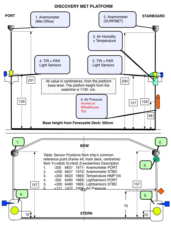
RRS Discovery cruise DY077 meteorology instrumentation
Instrumentation
The meteorological suite of sensors was located on the forecastle deck, at approximately 17.4 m above sea level. The anemometer orientation was 0° on the bow.
| Manufacturer | Model | Serial number | Last manufacturer's calibration date | Comments |
| Skye | SKE 510 | 38884 | 23/11/2016 | Port |
| Skye | SKE 510 | 28556 | 11/09/2015 | Starboard |
| Kipp and Zonen | CM6B | 962276 | 25/11/2016 | Port |
| Kipp and Zonen | CM6B | 962301 | 25/08/2015 | Starboard |
| Gill | Windsonic | 10280018 | - | No calibration required |
| Vaisala | Humidity and Temperature Probe HMP155 | K0950057 | 13/04/2016 | No calibration required |
| Vaisala | PTB210C Barometer Air pres | M2930080 | 20/07/2016 | No calibration required |
 |
Skye Instruments PAR Energy Sensor Model SKE 510
The SKE 510 is suitable for measuring photosynthetically active radiation (PAR) from natural or artificial light sources. The sensor is fully waterproof and guaranteed submersible to 4m depth, and indoor versions are also available.
The instrument uses a blue-enhanced planar diffused silicon detector to measure energy (in W m-2) over the 400-700 nm waveband. It has a cosine-corrected head and a square spectral response. The sensor can operate over a temperature range of -35 to 70 °C and a humidity range of 0-100% RH.
Specifications
| Sensitivity (current) | 1.5µA or 100 W m-2 |
|---|---|
| Sensitivity (voltage) | 1mV or 100 W m-2 |
| Working Range | 0-5000 W m-2 |
| Linearity error | 0.2% |
| Absolute calibration error | typ. less than 3% 5% max |
| Response time - voltage output | 10 ns |
| Cosine error | 3% |
| Azimuth error | less than 1% |
| Temperature co-efficient | ±0.1% per °C |
| Internal resistance - voltage output | c. 300 ohms |
| Longterm stability | ±2% |
| Material | Dupont 'Delrin' |
| Dimensions | 34 mm diameter 38mm height |
| Cable | 2 core screened 7 - 2 - 2C |
| Sensor Passband | 400 - 700 nm |
| Detector | Silicon photocell |
| Filters | Glass type and/or metal interference |
Vaisala PTB210 Digital Barometer
The basic specifications for this pressure sensor are as follows:
- Manufacturer: Vaisala
- Type: Silicon capacitive sensor
- Model: PTB210
- Range: 900 - 1100 hPa
- Output: 0-5VDC
- Total Accuracy (20°C): ±0.30hPa
- Operating temperature: -40 to +60 deg C
- Weight: 110g
- Certification Ingress Protection: IP65
Further details can be found in the manufacturer's specification sheet.
Vaisala Temperature and Relative Humidity HMP Sensors
A family of sensors and instruments (sensors plus integral displays or loggers) for the measurement of air temperature and relative humidity. All are based on a probe containing a patent (HUMICAP) capacitive thin polymer film capacitanece humidity sensor and a Pt100 platinum resistance thermometer. The probes are available with a wide range of packaging, cabling and interface options all of which have designations of the form HMPnn or HMPnnn such as HMP45 and HMP230. Vaisala sensors are incorporated into weather stations and marketed by Campbell Scientific.
All versions operate at up to 100% humidity. Operating temperature ranges vary between models, allowing users to select the version best suited to their requirements.
Further details can be found in the manufacturer's specification sheets for the HMP 45 series, HMP 70 series and HMP 230 series.
RRS Discovery cruise DY077 meteorology data processing procedures
Originator's Data Processing
The data were logged by the TECHSAS (TECHnical and Scientific sensors Acquisition System) version 5.9 data logging system into daily NetCDF files which were provided to BODC for processing. Data was additionally logged into the RVS Level-C format which have been archived at BODC.
Files delivered to BODC
| Filename | Content description | Format | Interval | Start date/time (UTC) | End date/time (UTC) | Comments |
| yyyymmdd-090000-MET-DY-SM_DY1.SURFMETv2 | Air temperature, humidity, relative wind speed, relative wind direction | NetCDF | ~ 1 sec. | 12/04/2017 09:38:11 | 01/05/2017 07:08:22 | |
| yyyymmdd-090000-Light-DY-SM_DY1.SURFMETv2 | Air pressure, PAR, TIR | NetCDF | ~ 1 sec. | 12/04/2017 09:38:11 | 01/05/2017 07:08:22 |
BODC Data Processing
The data were reformatted to BODC internal format using standard banking procedures. Data were averaged at 60 second intervals. The following table shows how variables within the file were mapped to appropriate BODC parameter codes:
yyyymmdd-090000-MET-DY-SM_DY1.SURFMETv2
| Originator's variable | Originator's units | Description | BODC Code | BODC Units | Unit conversion | Comments |
| direct | degrees | Apparent wind direction | ERWDSS01 | degrees | none | |
| speed | m/s | Apparent wind speed | ERWSSS01 | m/s | none | |
| airtemp | degree celsius | Air temperature | CDTAZZ01 | degrees celsius | none | |
| humid | % | Relative air humidity | CRELZZ01 | % | none | |
| time | days since 1899-12-30 00:00:00 UTC | Acquisition time | Not transferred |
yyyymmdd-090000-Light-DY-SM_DY1.SURFMETv2
| Originator's variable | Originator's units | Description | BODC Code | BODC Units | Unit conversion | Comments |
| ptir | Volt x 105 | Port total irradiance | CVLTRP01 | Volts | /100000 | |
| stir | Volt x 105 | Starboard total irradiance | CVLTRS01 | Volts | /100000 | |
| ppar | Volt x 105 | Port side PAR sensor | DVLTRPSD | Volts | /100000 | |
| spar | Volt x 105 | Port side starboard sensor | DVLTRSSD | Volts | /100000 | |
| pres | hectopascal | Atmospheric pressure | CAPHTU01 | millibar | none | |
| time | days since 1899-12-30 00:00:00 UTC | Acquisition time | Not transferred |
All data expressed at measurement altitude.
Calibrations
Field Calibrations
No field calibrations were applied to the data at BODC.
Manufacturers Calibrations
PAR/TIR
The following manufacturer's calibrations were applied to the PAR and TIR light sensors using:
y (W m -2 ) = (a x 10 6 )/b
where 'a' is the raw data in volts and 'b' is the calibration offset (µV per W m -2 ) as shown below.
| Sensor | Serial no | location | offset (µV per W m -2 ) |
| PAR | 38884 | Port | 9.435 |
| PAR | 28556 | Starboard | 9.783 |
| TIR | 962301 | Starboard | 9.74 |
| TIR | 962276 | Port | 10.13 |
All the reformatted data were visualised using the in-house EDSERPLO software. Suspect data were marked by adding an appropriate quality control flag.
Absolute wind speed and direction
Relative wind speed and direction were corrected for the ship's heading and speed using the POS MV gyro heading, ship velocities (calculated at BODC from the main positional channels) and an anemometer orientation of 0° on the bow, thus obtaining the BODC derived absolute wind speed and direction parameters, with codes EWSBSS01 and EWDASS01 respectively.
Air pressure
A manufacturer's calibration was not applied to the barometer because there was no significant offset reported on the certified calibration certificate.
Air temperature and humidity
Manufacturer's calibrations were not applied to the temperature and humidity probe because there were no significant offsets reported on the certified calibration certificate.
Project Information
Fix03 - Fixed-Point Open Ocean Observatories
Fixed point Open Ocean Observatory network (FixO3) is a EUR7 million, four-year (2013-2017) research programme network including 29 partners from academia, research institutions and small and medium enterprises (SME). In addition, 12 international experts from a wide range of disciplines comprise an Advisory Board.
Background
FixO3 is coordinated by the National Oceanography Centre, UK, and seeks to integrate European open ocean fixed point observatories and to improve access to these key installations for the broader community. These will provide multidisciplinary observations in all parts of the oceans from the air-sea interface to the deep seafloor. FixO3 will build on the significant advances achieved through the FP7 programmes EuroSITES, ESONET and CARBOOCEAN.
Open ocean observation is currently a high priority for European marine and maritime activities. FixO3 will provide important data on environmental products and services to address the Marine Strategy Framework Directive and in support of the EU integrated Maritime Policy.
The FixO3 network will provide free and open access to in situ fixed point data of the highest quality. It will provide a strong integrated framework of open ocean facilities in the Atlantic from the Arctic to the Antarctic and throughout the Mediterranean, enabling an integrated, regional and multidisciplinary approach to understand natural and anthropogenic change in the ocean.
The programme will be achieved through:
1. Co-ordination activities to integrate and harmonise the current procedures and processes. Strong links will be fostered with the wider community across academia, industry, policy and the general public through outreach, knowledge exchange and training.
2. Support actions to offer a) access to observatory infrastructures to those who do not have such access, and b) free and open data services and products.
3. Joint research activities to innovate and enhance the current capability for multidisciplinary in situ ocean observation.
Further details are available on the FixO3 website.
Participants
29 different partners involved in FixO3. These institutions are;
- Natural Environment Research Council (NERC)
- Istituto Nazionale di Oceanografia e di Geofisica Sperimentale (OGS)
- Hellenic Centre for Marine Research (HCMR)
- MARUM, Unviersity of Bremen (UniHB)
- Universitetet I Bergen (UiB)
- Universitetet I Tromsø (UiT)
- Alfred Wegener Institut für Polarund Meeresforschung (AWI)
- University of Exeter (UNEXE)
- SLR Consulting (SLR)
- Institut français de recherché pour l'exploitation de la mer (IFREMER)
- Blue Lobster IT ltd. (BLIT)
- Istituto Nazionale di Geofisica e Vulcanologia (INGV)
- Marine Institute (MI)
- The University Court of The University of Aberdeen (UNIABDN)
- Centre National de la Recherche Scientifique (CNRS)
- GEOMAR Helmholtz Centre for Ocean Research Kiel (GEOMAR)
- Universidad de las Palmas de Gran Canaria (ULPGC)
- University of St Andrew (USTAN)
- Spanish Institute of Oceanography (IEO)
- NKE Instrumentation (NKEI)
- Instituto Nacional de Desenvolvimento das Pescas (INDP)
- Universitat Politècnica de Catalunya (UPC)
- Texcel Technology Plc (TEXCEL)
- University of Gothenburg (UGOT)
- 52°North(52°North)
- Consiglio Nazionale delle Richerche (CNR)
- Stichting Koninklijk Nederlands Instituut Voor Zeeonderzoek (NIOZ)
- Imar- Instituto do Mar (IMAR)
Research details
Overall, twelve Work Packages have been funded by the FixO3 programme. These are described in brief below:
-
Work Package 1: Project Management.
- To effectively manage FixO3 to maximise the production of results in the most cost effective manner and to the proposed timescales.
- To facilitate communication and integration between the partners and disseminate information about the project to the wider community.
- To identify and resolve disputes between partners.
- To keep the project on track, and ensure timely interaction and delivery of reports to the European Commission. -
Work Package 2: Technical harmonization.
- To review the current status of existing systems in operational use considered in the project;
- To synthesize the characteristics of infrastructures offering TNA;
- To increase the high-frequency measurements on fixed platforms;
- To define the best technical practices for compatible, robust and cost-effective systems on a variety of fixed applications;
- To promote tests of new or prototype instruments on a non-operational basis;
- To define procedure for harmonizing and merging quality assessed high frequency fixed platform data;
- To define procedures and technological solutions for integration and testing of new sensors on these systems;
- To increase the traceability, quality and reliability of sensor metadata and data products. -
Work Package 3: Procedural harmonization.
To harmonise procedures across the network the following steps will be undertaken:
1) Assessment of operational procedures for sustained Eulerian observations
2) Further development of principles of 'best practice'
3) Development of the FixO3 observatories 'label' building on ESONET and in collaboration with JERICO
-
Work Package 4: Data management and harmonization.
To harmonise data policies and to provide a formal basis for data exchange between FixO3 infrastructures.
- To improve standardisation, interoperability and compliance with major international initiatives
- To harmonise data management and standardisation efforts with other European and international marine data and observatory infrastructures.
- To foster the cooperation with the marine carbon observation community by disseminating FixO3 data via relevant international infrastructures and data centres such as the ICOS Ocean Thematic Centre
To coordinate, harmonise and optimize the implementation and integration of Service Activities provided by the different partners in WP10 and to strengthen and monitor the dissemination of knowledge. -
Work Package 5: Innovation through industry.
- Promote interaction between the ocean observatory research community and the commercial sector
- Proactively promote FixO3 and wider open ocean observatory products and services to the commercial sector
- Identify innovative products and services within the ocean observatory community and develop targeted IPR agreements to encourage interest by the commercial sector. -
Work Package 6: Interface with policy and intergovernmental bodies.
- To link the FixO3 efforts to international and intergovernmental bodies and activities.
- To ensure visibility and facilitate further implementation and long-term stewardship of deep-ocean fixed-point time series observations
- To develop a strategy for the future. -
Work Package 7: International and European networking of fixed-point observatories
- To consolidate and promote the synergy between European research groups and institutions.
- To enhance the interaction with industry
- To link ocean scientists and engineers into an international team in marine science.
- Management of TNA activities. -
Work Package 8: Outreach and training.
- To engage with, educate and inform public, scientific and policy user groups.
- To develop an informative and interactive suite of complimentary tools that educates and engages public, scientific and policy user groups to maximise engagement with end users.
- To produce educational and informational resources that deliver knowledge to end user groups
- To deliver a series of training opportunities that informs, educates and promotes best practices to professional users of hardware, data and data products.
-
Work Package 9: Transnational access to FixO3 infrastructures
- To support external scientific users by providing coordinated, free-of-charge, transnational access to fixed open-ocean observatories, including:
1) Ocean surface, water column and seafloor observatory installations and systems considered for transnational access under this proposal
2) One shallow water test site able to make practical and fast tests of instruments, systems, procedures and new technologies applicable to fixed open-ocean observatories that will be accessible under TNA -
Work Package 10: Service activities: Access to data products and knowledge
- To provide access to the data products and knowledge derived from most of the observatories which compromise the FixO3 network. -
Work Package 11: Optimisation of ocean observing capability
- To carry out research on the specification for an optimum observational network of FixO3 platforms, integrated and complemented by other platforms. -
Work Package 12: Research and development on critical observatory functions
- To enhance the capability of the FixO3 infrastructures to make very high quality observations
- To develop a new low energy consuming platform design in order to promote more sensors per platform and extension capacities.
Observatories
FixO3
| Observatory | Location | Details |
|---|---|---|
| Antares | Ligurian Sea, NW Mediterranean Sea | Multidisciplinary, permanent marine observatory proving high-bandwidth real-time data transmission from deep-sea for geosciences and marine environmental sciences. Site is part of the MOOSE network providing real-time data transmission through two deep cabled moorings. These moorings are complemented by standalone mooring near the junction box. Physical and biogeochemical parameters recorded by autonomous sensors with regular maintenance. In addition, monthly ship occupation for CTD profiles and seawater collection. Cabled extension of the neutrino telescope is offering connectors for direct link to shore in addition to operational seismometer already in place. |
| Biscay AGL | South East Bay of Biscal | Fully equipped ODAS buoy transmitting data in real-time plus monthly hydrographical and biogeochemical sampling of water column from research vessel. Buoy obtains core measurements of meteorological, physical, biogeochemical and ecological parameters with high significance to weather forecasting and climate monitoring. Data immediately provided through IEO web page (hourly). |
| CIS | Central Irminger Sea, Subpolar North Atlantic. | Characterized by particular deep winter mixed layer depth. Mixed layer deepening is promoted through the combination of the cyclonic circulation of the Irminger gyre and strong surface buoyancy forcing in winter. Focus of the interdisciplinary research is on the biogeochemical cycling in a potential deep water formation area. The physical background field (temperature, salinity, currents) of the upper 1500m is surveyed with a number of sensors. Moreover, biogeochemical sensors (O2, Chl-a, zooplankton) is measured in mixed layer. |
| CVOO | Tropical Eastern North Atlantic | A mooring and a small vessel maintaining the time-series continuity. |
| DELOS (Deep-Ocean Environmental Long-term Observatory System) A | Angola, between the Congo and Kwanza rivers. | Environmental monitoring platform locations in the near field - within 50m of a sea floor well. The platform hosts a camera module, oceanographic module and acoustic module, each with multiple instruments, plus a sediment trap module. |
| DELOS (Deep-Ocean Environmental Long-term Observatory System) B | Angola, between the Congo and Kwanza rivers. | Environmental monitoring platform in the far field (~16km from sea floor infrastructure). On a flat <1° slope on finely sedimented sea floor within petroleum lease Block 18. The platform hosts a camera module, oceanographic module and acoustic module, each with multiple instruments, plus a sediment trap module. |
| DYFAMED | Ligurian Sea - a passage between Eastern and Western Mediterannean Sea. | Multidisciplinary site within MOOSE network. A strong influence of atmospheric deposition influencing productivity and particle export monitored by atmospheric survey (Cap Ferrat) and two permanent sediment traps. Physical parameters recorded from surface to deep waters through monthly visits and permanent deep mooring. Biogeochemical parameters obtained monthly during ship visits. The site is also a way point of gliders and used for cross-validation of bio-parameters (nitrate, oxygen). |
| E1-M3A | Eastern Mediterranean, Crete | Multidisciplinary mooring, an area of open sea conditions, characterized as extremely oligotrophic where dense waters with intermediate and deep characteristics are formed. |
| E2-M3A | South Adriatic Pit (Eastern Mediterranean Sea). | Two moorings (surface buoy and sub-surface mooring line) and designed to monitor physical and biogeochemical processes in the water column from the surface down to the bottom (approximately 1220m). The surface buoy collects air/sea meteorological and physical measurements in the surface layer (2m depth). The secondary deep mooring instead, is equipped with current meters (RDI-ADCP and Seaguard-RCM), CTD's with dissolved oxygen and optical sensors. New biochemical sensors (CO2 and pH) were deployed during the first year of the FixO3 project to enhance the payload of the site. |
| ESTOC | Central Eastern Atlantic | Open ocean site with over 15 years of continuous surface and mid-water meteorological, physical and biogeochemical monitoring. |
| FILCHNER RONNE | Filcher sill in the Souther Weddell Sea | Long-term monitoring of Ice Shelf Water (ISW) Overflow, established in 1977 and continuing to deliver the longest existing marine time series from Antarctica. The position for the observatory S2 proved to be a key site for monitoring the ISW overflow produced beneath the huge Filchner Ronne Ice Shelf and is selected to be a part of the global net of monitoring sites under CLIVAR (www.clivar.org) and OceanSITES (www.oceansites.org). Time series of current speed and direction, temperature and salinity exist back to 1977. Continuous observation of dissolved oxygen started in 2009. |
| FRAM | Fram Strait | Array of moorings and permanent sampling sites across the Fram Strait. Installed to capture the exchange of Atlantic and Arctic waters, and to study the temporal development of an Arctic Marine ecosystem. enables year-round multidisciplinary long-term observations, partially with near real-time data access. |
| LION | Gulf of Lion | Deep-sea mooring aims to observe the winter convection affecting the north-western Mediterranean Sea water circulation and deep-sea ecosystem (physical data). The mooring is deployed near the ODAS meteorological surface buoy (Gulf of Lion) and integrated in the MOOSE network. |
| MOMAR | Mid-Atlantic - Hydrothermal vent field Lucky Strike | Multidisciplinary (fauna, fluid chemistry, seismicity and ground deformation); near real time communication through acoustic link, buoy and satellite. EMSO observatory node, in operation since 2010, comprises an oceanographic mooring and nested arrays of seisometers, pressure probes, temperature probes and chemical sensors in vent fluids, as well as a camera and colonization devices for faunal and microfaunal studies. Satellite transmission of a data subset, accessible on an EMSO-related server. Yearly maintenance cruises scheduled until 2015. Upgrades of system planned for 2014 with several new connection nodes accessible to FixO3 collaborations. |
| NEMO-SN1 | Catania (Sicily) | Multidisciplinary (geophysics, oceanography, bioacoustics) observatory. Deep-sea real-time multi-parameter observatory is currently being re-deployed after refurbishment and installations of new electronics. |
| NOC | North Atlantic | Sediment trap mooring with current sensors in the least productive gyre in the North Atlantic, influence to a degree by dust supply from the Sahara desert. |
| OBSEA | Western Mediterranean | The main objective for OBSEA is to be a test bed for the development of oceanographic instrumentation while being a shallow-water observatory providing real time data and database with historical values. |
| PAP | North Atlantic | Array of moorings covering the entire water column and benthos with associated repeat ship occupations for process studies and collections not possible autonomously (e.g. benthic megafauna). Longest running multidisciplinary open ocean sustained observatory delivering atmospheric, physical, biogeochemical ocean datasets in near real time. |
| PYLOS | Adriatic and Eastern Mediterranean basins. | Multidisciplinary observatory mooring. Very geologically active area, with lots of earthquakes and landslides as well as a potential source of Tsunamis that might affect the Easter Mediterranean Sea. |
| SOG | South Atlantic | A sediment trap mooring with current sensors, in the middle of the least productive gyre in the South Atlantic (in contrast to NOG). It is not influenced by dust supply. |
| SOR | Mid-Atlantic RIdge, South of Svalbard. | Single location mooring. A component of NOON (Norwegian Ocean Observatory Network) planned as a demo mission in 2012, then as a sustained observatory in 2016. |
| Station M | Norwegian Sea | Ocean Weather Station M (OWS M) has been an ocean weather station since 1948. At present there is a mooring and surface buoy measuring hydrography, O2, chlorophyll and carbon parameters. Real-time and delayed-mode capabilities. This site provides the longest existing homogeneous time series from deep ocean. The facility presented here is the mooring situated between 150 and 2000m. |
| W1-M3A | Ligurian Sea | A single multidisciplinary observatory mooring with real-time and delayed mode capability. The W1-M3A observing system is composed by a large spar buoy and a sub-surface mooring periodically deployed close to the main buoy depending on specific research needs. The W1-M3A large spar buoy specifically designed for air-sea interaction studies and the collection of meteorological data even in rough sea. Stability is the basic feature of this type of buoy with respect to the other more classical approach based on discus-shaped buoys. The buoy was specifically designed as a stable measuring platform since its total mass, the unity buoyancy at the sea level, and presence of a damping disk allow for negligible sensitivity of sea heave and height. |
The British Oceanographic Data centre store data from PAP, NOG and SOG as of January 2018.
Data Activity or Cruise Information
Cruise
| Cruise Name | DY077 |
| Departure Date | 2017-04-14 |
| Arrival Date | 2017-05-01 |
| Principal Scientist(s) | Richard Stephen Lampitt (National Oceanography Centre, Southampton) |
| Ship | RRS Discovery |
Complete Cruise Metadata Report is available here
Fixed Station Information
No Fixed Station Information held for the Series
BODC Quality Control Flags
The following single character qualifying flags may be associated with one or more individual parameters with a data cycle:
| Flag | Description |
|---|---|
| Blank | Unqualified |
| < | Below detection limit |
| > | In excess of quoted value |
| A | Taxonomic flag for affinis (aff.) |
| B | Beginning of CTD Down/Up Cast |
| C | Taxonomic flag for confer (cf.) |
| D | Thermometric depth |
| E | End of CTD Down/Up Cast |
| G | Non-taxonomic biological characteristic uncertainty |
| H | Extrapolated value |
| I | Taxonomic flag for single species (sp.) |
| K | Improbable value - unknown quality control source |
| L | Improbable value - originator's quality control |
| M | Improbable value - BODC quality control |
| N | Null value |
| O | Improbable value - user quality control |
| P | Trace/calm |
| Q | Indeterminate |
| R | Replacement value |
| S | Estimated value |
| T | Interpolated value |
| U | Uncalibrated |
| W | Control value |
| X | Excessive difference |
SeaDataNet Quality Control Flags
The following single character qualifying flags may be associated with one or more individual parameters with a data cycle:
| Flag | Description |
|---|---|
| 0 | no quality control |
| 1 | good value |
| 2 | probably good value |
| 3 | probably bad value |
| 4 | bad value |
| 5 | changed value |
| 6 | value below detection |
| 7 | value in excess |
| 8 | interpolated value |
| 9 | missing value |
| A | value phenomenon uncertain |
| B | nominal value |
| Q | value below limit of quantification |
