Metadata Report for BODC Series Reference Number 1736205
Metadata Summary
Problem Reports
Data Access Policy
Narrative Documents
Project Information
Data Activity or Cruise Information
Fixed Station Information
BODC Quality Flags
SeaDataNet Quality Flags
Metadata Summary
Data Description |
|||||||||||||||||||||||||||||||||||||||||||||||||
|
|||||||||||||||||||||||||||||||||||||||||||||||||
Data Identifiers |
|||||||||||||||||||||||||||||||||||||||||||||||||
|
|||||||||||||||||||||||||||||||||||||||||||||||||
Time Co-ordinates(UT) |
|||||||||||||||||||||||||||||||||||||||||||||||||
|
|||||||||||||||||||||||||||||||||||||||||||||||||
Spatial Co-ordinates | |||||||||||||||||||||||||||||||||||||||||||||||||
|
|||||||||||||||||||||||||||||||||||||||||||||||||
Parameters |
|||||||||||||||||||||||||||||||||||||||||||||||||
|
|||||||||||||||||||||||||||||||||||||||||||||||||
|
|||||||||||||||||||||||||||||||||||||||||||||||||
Problem Reports
No Problem Report Found in the Database
RRS Discovery DY033 meteorological data quality report
Further to the data processing documentation, data quality issues concerning meteorology data were noted.
Wind speed and direction
A few spikes in all wind parameters were detected and flagged accordingly.
Several sudden drops or spikes in relative and absolute wind direction were recorded during changes in the ship's heading, more specifically when the relative wind direction was 180 degrees. This strongly suggests a temporary shielding of the anemometer, and the data were therefore flagged.
Treat with caution wind data between 19/07/2015 at 21:30 and 20/07/2015 at 05:30, as these measurements coincide when the ship was stationary and the wind consistently blowing at a relative direction of 180 degrees. The noisy data that results from these conditions is likely caused by prolonged shielding of the anemometer.
PAR and TIR
All PAR and TIR channels display consistent negative readings during night time. This most likely results from excessive loss of radiation after sunset, which suggests that day-time data recorded during cloud cover should also be treated with caution. Another explanation would be that out dated calibrations added an offset to the data, however this is less likely as the four sensors were calibrated at very different times yet all record similar negative night values. All negative PAR and TIR data were flagged.
There appeared to be several instances of shading between the original port/starboard PAR and TIR sensor pairs. This issue was solved by creating a new, unique channel for PAR and TIR respectively, composed of the maximum values per data cycle between each pair of sensors.
Air temperature, relative humidity and atmospheric pressure
Treat with caution data recorded on 11/07/2015 from the start of the record at 16:43 until 17:40, as relative humidity is unusually low and temperature unusually high. These parameters were not flagged during this period, as it is unclear whether a weather front had been crossed, or whether the sensors were still adjusting after having been switched on.
Data Access Policy
Open Data
These data have no specific confidentiality restrictions for users. However, users must acknowledge data sources as it is not ethical to publish data without proper attribution. Any publication or other output resulting from usage of the data should include an acknowledgment.
If the Information Provider does not provide a specific attribution statement, or if you are using Information from several Information Providers and multiple attributions are not practical in your product or application, you may consider using the following:
"Contains public sector information licensed under the Open Government Licence v1.0."
Narrative Documents
Gill Instruments Windsonic Anemometer
The Gill Windsonic is a 2-axis ultrasonic wind sensor that monitors wind speed and direction using four transducers. The time taken for an ultrasonic pulse to travel from the North to the South transducers is measured and compared with the time for a pulse to travel from South to North. Travel times between the East and West transducers are similarly compared. The wind speed and direction are calculated from the differences in the times of flight along each axis. This calculation is independent of environmental factors such as temperature.
Specifications
| Ultrasonic output rate | 0.25, 0.5, 1, 2 or 4 Hz |
| Operating Temperature | -35 to 70°C |
| Operating Humidity | < 5 to 100% RH |
| Anemometer start up time | < 5 s |
| Wind speed | |
| Range | 0 to 60 m s-1 |
| Accuracy | ± 2% at 2 m s-1 |
| Resolution | 0.01 m s-1 |
| Response time | 0.25 s |
| Threshold | 0.01 m s-1 |
| Wind direction | |
| Range | 0 to 359° |
| Accuracy | ± 3° at 12 m s-1 |
| Resolution | 1° |
| Response time | 0.25 s |
Further details can be found in the manufacturer's specification sheet.
Kipp and Zonen Pyranometer Model CM6B
The CM6B pyranometer is intended for routine global solar radiation measurement research on a level surface. The CM6B features a sixty-four thermocouple junction (series connected) sensing element. The sensing element is coated with a highly stable carbon based non-organic coating, which delivers excellent spectral absorption and long term stability characteristics. The sensing element is housed under two concentric fitting Schott K5 glass domes.
Specifications
| Dimensions (W x H) | 150.0 mm x 91.5 mm |
|---|---|
| Weight | 850 grams |
| Operating Temperature | -40°C to +80°C |
| Spectral Range | 305 - 2800 nm (50% points) |
| Sensitivity | 9 -15 µV/W/m2 |
| Impedance (nominal) | 70 - 100 ohm |
| Response Time (95%) | 30 sec |
| Non-linearity | < ± 1.2% (<1000 W/m2) |
| Temperature dependence of sensitivity | < ± 2% (-10 to +40°C) |
| Zero-offset due to temperature changes | < ± 4 W/m2 at 5 K/h temperature change |
RRS Discovery DY033 meteorology instrumentation
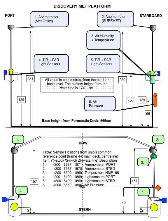
The meteorological suite of sensors was located on the forecastle deck, at approximately 17.4 m above sea level. The anemometer orientation was 0° on the bow.
The following instruments were used for meteorological measurements:
| Manufacturer | Model | Serial number | Last manufacturer's calibration date | Comments |
| Skye | SKE 510 | 28561 | 30/04/2015 | Port |
| Skye | SKE 510 | 28556 | 04/07/2013 | Starboard |
| Kipp and Zonen | CM 6B | 973134 | 19/03/2015 | Port |
| Kipp and Zonen | CM 6B | 962276 | 13/11/2014 | Starboard |
| Gill | Windsonic (Option 3) | 071121 | - | No calibration required |
| Vaisala | HMP155 | K0950058 | 19/01/2015 | No calibration required |
| Vaisala | PTB110 | L0650612 | 06/02/2015 | No calibration required |
 |
Skye Instruments PAR Energy Sensor Model SKE 510
The SKE 510 is suitable for measuring photosynthetically active radiation (PAR) from natural or artificial light sources. The sensor is fully waterproof and guaranteed submersible to 4m depth, and indoor versions are also available.
The instrument uses a blue-enhanced planar diffused silicon detector to measure energy (in W m-2) over the 400-700 nm waveband. It has a cosine-corrected head and a square spectral response. The sensor can operate over a temperature range of -35 to 70 °C and a humidity range of 0-100% RH.
Specifications
| Sensitivity (current) | 1.5µA or 100 W m-2 |
|---|---|
| Sensitivity (voltage) | 1mV or 100 W m-2 |
| Working Range | 0-5000 W m-2 |
| Linearity error | 0.2% |
| Absolute calibration error | typ. less than 3% 5% max |
| Response time - voltage output | 10 ns |
| Cosine error | 3% |
| Azimuth error | less than 1% |
| Temperature co-efficient | ±0.1% per °C |
| Internal resistance - voltage output | c. 300 ohms |
| Longterm stability | ±2% |
| Material | Dupont 'Delrin' |
| Dimensions | 34 mm diameter 38mm height |
| Cable | 2 core screened 7 - 2 - 2C |
| Sensor Passband | 400 - 700 nm |
| Detector | Silicon photocell |
| Filters | Glass type and/or metal interference |
Vaisala PTB110 barometer
An industrial, analog barometer which uses a silicon capacitive sensor (BAROCAP). The sensor produces either frequency or voltage output and is mountable on a (35 mm wide) DIN rail.
Operating ranges (1 hPa = 1 mbar)
| Pressure ranges | 500 ... 1100 hPa 600 ... 1100 hPa 800 ... 1100 hPa 800 ... 1060 hPa 600 ... 1060 hPa |
| Temperature range | -40 ... +60 °C (-40 ... +140 °F) |
| Humidity range | non-condensing |
General
| Output voltage | 0 ... 2.5 VDC 0 ... 5 VDC |
| Output frequency | 500 ... 1100 Hz |
| Resolution | 0.1 hPa |
Accuracy
| Linearity* | ±0.25 hPa |
| Hysteresis* | ±0.03 hPa |
| Repeatability* | ±0.03 hPa |
| Pressure calibration uncertainty** | ±0.15 hPa |
| Accuracy at +20 °C*** | ±0.3 hPa |
| Total accuracy at: | |
| +15 ... +25 °C (+59 ... +77 °F) 0 ... +40 °C (+32 ... +104 °F) -20 ... +45 °C (-4 ... +113 °F) -40 ... +60 °C (-40 ... +140 °F) | ±0.3 hPa ±0.6 hPa ±1.0 hPa ±1.5 hPa |
* Defined as ±2 standard deviation limits of end-point non-linearity, hysteresis error or repeatability error.
** Defined as ±2 standard deviation limits of inaccuracy of the working standard including traceability to NIST.
*** Defined as the root sum of the squares (RSS) of end-point non-linearity, hysteresis error, repeatability error and calibration uncertainty at room temperature when using voltage output.
More detailed information can be found in the manufacturer's data sheet and user's guide.
Vaisala Temperature and Relative Humidity HMP Sensors
A family of sensors and instruments (sensors plus integral displays or loggers) for the measurement of air temperature and relative humidity. All are based on a probe containing a patent (HUMICAP) capacitive thin polymer film capacitanece humidity sensor and a Pt100 platinum resistance thermometer. The probes are available with a wide range of packaging, cabling and interface options all of which have designations of the form HMPnn or HMPnnn such as HMP45 and HMP230. Vaisala sensors are incorporated into weather stations and marketed by Campbell Scientific.
All versions operate at up to 100% humidity. Operating temperature ranges vary between models, allowing users to select the version best suited to their requirements.
Further details can be found in the manufacturer's specification sheets for the HMP 45 series, HMP 70 series and HMP 230 series.
RRS Discovery DY033 meteorology data processing procedures
Originator's Data Processing
The data were logged by the TECHSAS (TECHnical and Scientific sensors Acquisition System) system into NetCDF, pseudo-TECHSAS ascii and UKORS RVS Level-C format files. All subsequent processing was carried out using internally developed Matlab routines.
The data were submitted to BODC in ascii format for post-cruise processing and data banking.
Air temperature, humidity and pressure
The daily pseudo-TECHSAS ascii files containing air temperature, humidity and pressure data were reformatted and appended. The data were then filtered of noise, by applying moving average windows of 120 seconds for air temperature data, and of 60 seconds for humidity and pressure data. All data points outside two standard deviations of the filtering average used were removed.
PAR and TIR
The daily pseudo-TECHSAS ascii files contacting PAR and TIR data were reformatted and appended. The appropriate manufacturer's calibrations were applied to the starboard and port pair of sensors, as follows:
cal (W m-2) = (voltage x 106) / a
Where 'cal' is the calibrated data, 'voltage' is the raw instrument output data multiplied by 10-5, and 'a' is the manufacturer's calibration offset in µV per W m-2 as shown below:
| Sensor | Serial no | location | offset (µV per W m-2) |
| PAR | 28561 | port | 11.05 |
| PAR | 28556 | starboard | 10.36 |
| TIR | 973134 | port | 10.97 |
| TIR | 962276 | starboard | 10.14 |
Winds
The level-C logging system files containing relative and absolute wind speed and direction data were processed, reformatted and appended using internal routines. Suspect data were flagged and all wind direction data values greater than 360 degrees were removed. The data were then filtered of noise, by applying moving average windows of 120 seconds, and all data values outside two standard deviations of the filtering average were removed.
For more detailed information on the Originator's underway data processing, please see the cruise report, p27-38.
Files delivered to BODC
Note: each file was split in two by the originator due to storage problems linked to file size.
| Filename | Content description | Format | Interval | Start date/time (UTC) | End date/time (UTC) | Comments |
| DY033_MET_master_filt_110715_200715 | Air temperature, humidity and pressure (part 1) | ASCII | ~ 1 sec. | 11/07/2015 16:43:41 | 21/07/2015 08:59:59 | Preferred source |
| DY033_MET_master_filt_210715_020815 | Air temperature, humidity and pressure (part 2) | ASCII | ~ 1 sec. | 21/07/2015 09:00:00 | 02/08/2015 13:40:06 | Preferred source |
| DY033_PIRTIR_master_raw_110715_200715 | PAR and TIR data (part 1) | ASCII | ~ 1 sec. | 11/07/2015 16:43:41 | 21/07/2015 08:59:59 | Only source |
| DY033_PIRTIR_master_raw_210715_020815 | PAR and TIR data (part 2) | ASCII | ~ 1 sec. | 21/07/2015 09:00:00 | 02/08/2015 13:40:06 | Only source |
| DY033_PRO_master_filt_110715_200715 | Relative and absolute wind data (part 1) | ASCII | ~ 1 sec. | 11/07/2015 00:00:00 | 20/07/2015 23:59:59 | Preferred source |
| DY033_PRO_master_filt_210715_020815 | Relative and absolute wind data (part 2) | ASCII | ~ 1 sec. | 21/07/2015 00:00:00 | 01/08/2015 23:59:59 | Preferred source |
BODC Data Processing
Reformatting
Underway data files were reformatted to NetCDF using BODC standard data banking procedures, and merged into a single file using time as the primary linking key. The time span of the file is 11/07/2015 16:43:42 to 02/08/2015 13:40:12, with a sampling interval of 30 seconds.
The following tables show how variables within the file were mapped to appropriate BODC parameter codes:
DY033_MET_master_filt_110715_200715, DY033_MET_master_filt_210715_020815
| Originator's variable | Originator's units | Description | BODC Code | BODC Units | Unit conversion | Comments |
| dd | Matlab datenumber | Preferred date and time format | ||||
| days | decimal day number | Not transferred | ||||
| airtemp | degree celsius | Air temperature | CDTASS01 | degrees celsius | ||
| airtempF | Quality flag | Converted to corresponding BODC flags. | ||||
| humidity | % | Relative humidity of the air | CRELSS01 | |||
| humidityF | Quality flag | Converted to corresponding BODC flags. | ||||
| pres | hPa | Air pressure | CAPHTU01 | mBar | 1:1 conversion | |
| presF | Quality flag | Converted to corresponding BODC flags. |
DY033_PIRTIR_master_raw_110715_200715, DY033_PIRTIR_master_raw_210715_020815
| Originator's variable | Originator's units | Description | BODC Code | BODC Units | Unit conversion | Comments |
| dd | Matlab datenumber | Preferred date and time format | ||||
| days | decimal day number | Not transferred | ||||
| ppar | W m-2 | Port side PAR sensor | DWIRRPSD | W m-2 | ||
| pparF | Quality flag | Converted to corresponding BODC flags. | ||||
| spar | W m-2 | Starboard side PAR sensor | DWIRRSSD | W m-2 | ||
| sparF | Quality flag | Converted to corresponding BODC flags. | ||||
| ptir | W m-2 | Port side TIR sensor | CSLRRP01 | W m-2 | ||
| ptirF | Quality flag | Converted to corresponding BODC flags. | ||||
| stir | W m-2 | Starboard side TIR sensor | CSLRRS01 | W m-2 | ||
| stirF | Quality flag | Converted to corresponding BODC flags. |
DY033_PRO_master_filt_110715_200715, DY033_PRO_master_filt_210715_020815
| Originator's variable | Originator's units | Description | BODC Code | BODC Units | Unit conversion | Comments |
| dd | Matlab datenumber | Preferred date and time format | ||||
| days | decimal day number | Not transferred | ||||
| relwindspd | m s-1 | Relative wind speed | ERWSSS01 | m s-1 | ||
| relwindspdF | Quality flag | Converted to corresponding BODC flags. | ||||
| relwinddir | Degrees | Relative wind direction | ERWDSS01 | Degrees | 0° on the bow | |
| relwinddirF | Quality flag | Converted to corresponding BODC flags. | ||||
| abswindspd | m s-1 | Absolute wind speed | Not banked, as derived at BODC | |||
| abswindspdF | Quality flag | |||||
| abswinddir | Degrees True | Absolute wind direction | Not banked, as derived at BODC | |||
| abswinddirF | Quality flag |
All data expressed at measurement altitude.
Screening
All reformatted data were inspected on a graphics workstation, and any spikes or dubious data were flagged. The workstation software also allowed comparative screening checks between channels, carried out by overlaying data channels.
Data processing, correction and calibration
No field calibrations were applied to the data at BODC.
Absolute wind speed and direction
Relative wind speed and direction were corrected for the ship's heading and speed using the POS MV gyro heading, ship velocities (calculated at BODC from the main positional channels) and an anemometer orientation of 0° on the bow, thus obtaining the BODC derived absolute wind speed and direction parameters, with codes EWSBSS01 and ERWDSS01 respectively.
PAR and TIR
The maximum values between the port-side and starboard-side sensor pairs were extracted into single new PAR and TIR data channels to eliminate the effects of shading. These resulted in the BODC derived parameters DWIRRXMX and CSLRR1XS.
Air pressure
A manufacturer's calibration was not applied to the barometer because there was no significant offset reported on the certified calibration certificate.
Air temperature and humidity
Manufacturer's calibrations were not applied to the temperature and humidity probe because there were no significant offsets reported on the certified calibration certificate.
Project Information
Shelf Sea Biogeochemistry (SSB) Programme
Shelf Sea Biogeochemistry (SSB) is a £10.5 million, six-year (2011-2017) research programme, jointly funded by the Natural Environment Research Council (NERC) and the Department for Environment, Food and Rural Affairs (DEFRA). The aim of the research is to reduce the uncertainty in our understanding of nutrient and carbon cycling within the shelf seas, and of their role in global biogeochemical cycles. SSB will also provide effective policy advice and make a significant contribution to the Living with Environmental Change programme.
Background
The Shelf Sea Biogeochemistry research programme directly relates to the delivery of the NERC Earth system science theme and aims to provide evidence that supports a number of marine policy areas and statutory requirements, such as the Marine Strategy Framework Directive and Marine and Climate Acts.
The shelf seas are highly productive compared to the open ocean, a productivity that underpins more than 90 per cent of global fisheries. Their importance to society extends beyond food production to include issues of biodiversity, carbon cycling and storage, waste disposal, nutrient cycling, recreation and renewable energy resources.
The shelf seas have been estimated to be the most valuable biome on Earth, but they are under considerable stress, as a result of anthropogenic nutrient loading, overfishing, habitat disturbance, climate change and other impacts.
However, even within the relatively well-studied European shelf seas, fundamental biogeochemical processes are poorly understood. For example: the role of shelf seas in carbon storage; in the global cycles of key nutrients (nitrogen, phosphorus, silicon and iron); and in determining primary and secondary production, and thereby underpinning the future delivery of many other ecosystem services.
Improved knowledge of such factors is not only required by marine policymakers; it also has the potential to increase the quality and cost-effectiveness of management decisions at the local, national and international levels under conditions of climate change.
The Shelf Sea Biogeochemistry research programme will take a holistic approach to the cycling of nutrients and carbon and the controls on primary and secondary production in UK and European shelf seas, to increase understanding of these processes and their role in wider biogeochemical cycles. It will thereby significantly improve predictive marine biogeochemical and ecosystem models over a range of scales.
The scope of the programme includes exchanges with the open ocean (transport on and off the shelf to a depth of around 500m), together with cycling, storage and release processes on the shelf slope, and air-sea exchange of greenhouse gases (carbon dioxide and nitrous oxide).
Further details are available on the SSB website.
Participants
15 different organisations are directly involved in research for SSB. These institutions are
- Centre for Environment, Fisheries and Aquaculture Science (Cefas)
- Meteorological Office
- National Oceanography Centre (NOC)
- Plymouth Marine Laboratory (PML)
- Scottish Association for Marine Science (SAMS) / Scottish Marine Institute (SMI)
- University of Aberdeen
- University of Bangor
- University of East Anglia (UEA)
- University of Edinburgh
- University of Essex
- University of Liverpool
- University of Oxford
- Plymouth University
- University of Portsmouth
- University of Southampton
In addition, there are third party institutions carrying out sampling work for SSB, but who are not involved in the programme itself. These are:
- The Agri-Food and Biosciences Institute (AFBI)
- Irish Marine Institute (MI)
- Marine Science Scotland (MSS)
Research details
Overall, five Work Packages have been funded by the SSB programme. These are described in brief below:
-
Work Package 1: Carbon and Nutrient Dynamics and Fluxes over Shelf Systems (CaNDyFloSS).
This work package aims to perform a comprehensive study of the cycling of nutrients and carbon throughout the water column over the whole north-west European shelf. This will allow the fluxes of nutrients and carbon between the shelf and the deep ocean and atmosphere to be quantified, establishing the role of the north-west European continental shelf in the global carbon cycle. -
Work Package 2: Biogeochemistry, macronutrient and carbon cycling in the benthic layer.
This work package aims are to map the sensitivity and status of seabed habitats, based on physical conditions, ecological community structure and the size and dynamics of the nitrogen and carbon pools found there. This information will be used, in conjunction with some laboratory-based work, to generate an understanding of the potential impacts on the benthic community as a result of changing environmental conditions, such as rising CO2 levels. -
Work Package 3: The supply of iron from shelf sediments to the ocean.
The research for this work package addresses the question of how currents, tides, weather and marine chemistry allow new iron to be transported away from the shallow shelf waters around the United Kingdom (UK), to the nearby open ocean. This will ultimately allow an improved understanding of how the transport of iron in shelf waters and shelf sediments influences phytoplankton growth in open oceans. This in turn improves the understanding of carbon dioxide uptake by phytoplankton. -
Work Package 4: Integrative modelling for Shelf Seas Biogeochemistry.
The aim of this work package is the development of a new shelf seas biogeochemical model system, coupled to a state of the art physical model, that is capable of predicting regional impacts of environmental change of timescales from days to decades. It is envisaged that the combination of predictive tools and new knowledge developed in this work package will underpin development and implementation of marine policy and marine forecasting systems. - Work Package 5: Data synthesis and management of marine and coastal carbon (DSMMAC).
This work package is funded by Defra and is also known by the name 'Blue Carbon'. The aim is to provide a process-based, quantitative assessment of the role of UK coastal waters and shelf seas in carbon storage and release, using existing data and understanding, and also emerging results from SSB fieldwork, experiments and modelling. Particular emphasis will be given to processes that may be influenced by human activities, and hence the opportunity for management interventions to enhance carbon sequestration.
Fieldwork and data collection
The campaign consists of the core cruises in the table below, to the marine shelf (and shelf-edge) of the Celtic Sea on board the NERC research vessels RRS Discovery and RRS James Cook. These cruises will focus on the physics and biogeochemistry of the benthic and pelagic zones of the water column, primarily around four main sampling sites in this area.
| Cruise identifier | Research ship | Cruise dates | Work packages |
|---|---|---|---|
| DY008 | RRS Discovery | March 2014 | WP 2 and WP 3 |
| JC105 | RRS James Cook | June 2014 | WP 1, WP 2 and WP 3 |
| DY026 | RRS Discovery | August 2014 | WP1, WP 2 and WP 3 |
| DY018 | RRS Discovery | November - December 2014 | WP 1 and WP 3 |
| DY021 (also known as DY008b) | RRS Discovery | March 2015 | WP 2 and WP 3 |
| DY029 | RRS Discovery | April 2015 | WP 1 and WP 3 |
| DY030 | RRS Discovery | May 2015 | WP 2 and WP 3 |
| DY033 | RRS Discovery | July 2015 | WP 1 and WP 3 |
| DY034 | RRS Discovery | August 2015 | WP 2 and WP 3 |
Core cruises will be supplemented by partner cruises led by Cefas, MI, MSS, Bangor University and AFBI, spanning the shelf seas and shelf-edges around United Kingdom and Republic of Ireland.
Activities will include coring, Conductivity Temperature and Depth (CTD) deployments, Acoustic Doppler Current Profilers (ADCP) surveys, moorings and wire-walker deployments, benthic lander observatories, autonomous gliders and submersible surveys, Marine Snow Catcher particulate matter analysis, plankton net hauls, in-situ sediment flume investigations and laboratory incubations with core and sea water samples.
Shelf Sea Biogeochemistry (SSB) Programme Work Package 1: CaNDyFloSS
Carbon and Nutrient Dynamics and Fluxes over Shelf Systems (CaNDyFloSS) is a £2.76 million component of the Natural Environment Research Council (NERC) Shelf Sea Biogeochemistry (SSB) research programme, running from 2013 to 2017. It is jointly funded by NERC and the Department for Environment, Food and Rural Affairs (DEFRA). The aim of the research is to perform a comprehensive study of the cycling of nutrients and carbon throughout the water column over the whole north-west European shelf. This will allow the fluxes of nutrients and carbon between the shelf and the deep ocean and atmosphere to be quantified, establishing the role of the north-west European continental shelf in the global carbon cycle.
Background
Shelf seas are the primary regions of human marine resource exploitation, including both renewable and fossil fuel energy sources, recreation, trade and food production. They provide 90% of global fish catches which form an important source of food to much of the global population. They also play an important role in the ecosystem services provided by the oceans as a whole, in particular in storing carbon away from the atmosphere.
Physical and biochemical processes in shelf seas influence the removal of CO2 from the atmosphere and the subsequent storage of carbon in the deep ocean. Biological growth draws carbon out of the water, which is then replaced by carbon in CO2 from the atmosphere. In the shelf seas this growth is supported by terrestrial and open ocean sources of nutrients, implying intimate roles for both the terrestrial biosphere and the open ocean environment in regulating shelf sea climate services. The oceans can also be a major source or sink for other greenhouse gases, including nitrous oxide (N2O), with the shallow shelf sea thought to play a key role.
The spatial extent of the submerged continental shelves varies greatly. The NW European shelf sea is one of the largest and hence is likely to play a significant role in marine biogeochemical cycling, alongside providing a useful model for other systems. However, even in this relatively well studied region, there is a lack of detailed understanding of the principal controls on the cycling of carbon and the major nutrient elements, nitrogen, phosphorus and silicon. Consequently it is also difficult to predict how the cycling of these elements and hence the carbon removal they support may be altered by ongoing and potential future global change. This work package aims to address these uncertainties through a comprehensive study of the cycling of the major nutrients and carbon throughout the water column over the NW European shelf sea system.
Further details are available on the SSB website.
Participants
9 different organisations are directly involved in research for SSB Work Package 1. These institutions are
- Centre for Environment, Fisheries and Aquaculture Science (Cefas)
- National Oceanography Centre (NOC)
- Plymouth Marine Laboratory (PML)
- Scottish Association for Marine Science (SAMS) / Scottish Marine Institute (SMI)
- University of Aberdeen
- University of Bangor
- University of East Anglia (UEA)
- University of Liverpool
- University of Southampton
In addition, there are third party institutions carrying out sampling work for SSB Work Package 1, but who are not involved in the programme itself. These are:
- The Agri-Food and Biosciences Institute (AFBI)
- Irish Marine Institute (MI)
- Marine Science Scotland (MSS)
Objectives
Two overarching objectives are defined for this Work Package.
-
Objective 1: Estimate the size of the continental shelf carbon pump over the whole north-west European shelf.
This will consist of two principal activities. (1) Over a 12 month period, observations of air-sea CO2 fluxes will be made to provide a synoptic estimate of the magnitude of carbon update by the whole shelf system. (2) Concentrations of carbon (C), nitrogen (N), phosphate (P) and silicate (Si) will be estimated in water flowing on and off the shelf. These estimates will be coupled to estimates of flow and dispersion along the shelf edge, through collaboration with the NERC Fluxes across Sloping Topography of the North East Atlantic (FASTNEt) programme to allow an observational estimate of the net off-shelf transport of C, N, P and Si. -
Objective 2: Determine the relative importance of external nutrient sources and internal biogeochemical cycling in maintaining the continental shelf pump.
Estimates of the flux of nutrients and carbon generated in Objective 1 will be used to determine the estimation of any excess of on-shelf nutrient supply, relative to that of carbon. Work Package 1 will then quantify the processes which govern internal biogeochemical cycling by measuring the uptake ratios of N, P, Si and C into phytoplankton and the element and energy balance of organic matter production by autotrophs. Potential modifications to the relative concentrations and uptake of C, N, P and Si in the thermocline and sediment food webs will also be assessed, as will the relative importance of microbial and zooplankton turnover in controlling C, N, P and Si.
Fieldwork and data collection
Data for Objective 1 will be provided using pCO2 systems aboard third party vessels and ferry boxes, along with measurements made through the FASTNEt programme and through the Work Package 1 process cruises detailed below. The third party cruises will be undertaken by Cefas, MI, MSS, University of Bangor and AFBI, spanning the shelf seas and shelf-edges around the United Kingdom and the Republic of Ireland.
The Work Package 1 process cruises will provide data for Objective 1 and Objective 2 and are listed in the table below. The study area is the marine shelf (and shelf-edge) of the Celtic Sea. Work will be carried out on board the NERC research vessels RRS Discovery and RRS James Cook. These cruises will focus on the physics and biogeochemistry of the benthic and pelagic zones of the water column, primarily around four main sampling sites in this area.
| Cruise identifier | Research ship | Cruise dates | Work packages |
|---|---|---|---|
| JC105 | RRS James Cook | June 2014 | WP 1, WP 2 and WP 3 |
| DY026 | RRS Discovery | August 2014 | WP1, WP 2 and WP 3 |
| DY018 | RRS Discovery | November - December 2014 | WP 1 and WP 3 |
| DY029 | RRS Discovery | April 2015 | WP 1 and WP 3 |
| DY033 | RRS Discovery | July 2015 | WP 1 and WP 3 |
Activities will include Conductivity Temperature and Depth (CTD) deployments, Acoustic Doppler Current Profilers (ADCP) surveys, moorings and wire-walker deployments, autonomous gliders and submersible surveys, Marine Snow Catcher particulate matter analysis, plankton net hauls and laboratory incubations with sea water samples.
Data Activity or Cruise Information
Cruise
| Cruise Name | DY033 (GApr04) |
| Departure Date | 2015-07-11 |
| Arrival Date | 2015-08-02 |
| Principal Scientist(s) | C Mark Moore (National Oceanography Centre, Southampton) |
| Ship | RRS Discovery |
Complete Cruise Metadata Report is available here
Fixed Station Information
No Fixed Station Information held for the Series
BODC Quality Control Flags
The following single character qualifying flags may be associated with one or more individual parameters with a data cycle:
| Flag | Description |
|---|---|
| Blank | Unqualified |
| < | Below detection limit |
| > | In excess of quoted value |
| A | Taxonomic flag for affinis (aff.) |
| B | Beginning of CTD Down/Up Cast |
| C | Taxonomic flag for confer (cf.) |
| D | Thermometric depth |
| E | End of CTD Down/Up Cast |
| G | Non-taxonomic biological characteristic uncertainty |
| H | Extrapolated value |
| I | Taxonomic flag for single species (sp.) |
| K | Improbable value - unknown quality control source |
| L | Improbable value - originator's quality control |
| M | Improbable value - BODC quality control |
| N | Null value |
| O | Improbable value - user quality control |
| P | Trace/calm |
| Q | Indeterminate |
| R | Replacement value |
| S | Estimated value |
| T | Interpolated value |
| U | Uncalibrated |
| W | Control value |
| X | Excessive difference |
SeaDataNet Quality Control Flags
The following single character qualifying flags may be associated with one or more individual parameters with a data cycle:
| Flag | Description |
|---|---|
| 0 | no quality control |
| 1 | good value |
| 2 | probably good value |
| 3 | probably bad value |
| 4 | bad value |
| 5 | changed value |
| 6 | value below detection |
| 7 | value in excess |
| 8 | interpolated value |
| 9 | missing value |
| A | value phenomenon uncertain |
| B | nominal value |
| Q | value below limit of quantification |
