Metadata Report for BODC Series Reference Number 1851786
Metadata Summary
Problem Reports
Data Access Policy
Narrative Documents
Project Information
Data Activity or Cruise Information
Fixed Station Information
BODC Quality Flags
SeaDataNet Quality Flags
Metadata Summary
Data Description |
|||||||||||||||||||||||||||||||||
|
|||||||||||||||||||||||||||||||||
Data Identifiers |
|||||||||||||||||||||||||||||||||
|
|||||||||||||||||||||||||||||||||
Time Co-ordinates(UT) |
|||||||||||||||||||||||||||||||||
|
|||||||||||||||||||||||||||||||||
Spatial Co-ordinates | |||||||||||||||||||||||||||||||||
|
|||||||||||||||||||||||||||||||||
Parameters |
|||||||||||||||||||||||||||||||||
|
|||||||||||||||||||||||||||||||||
Definition of BOTTFLAG | |||||||||||||||||||||||||||||||||
| BOTTFLAG | Definition |
|---|---|
| 0 | The sampling event occurred without any incident being reported to BODC. |
| 1 | The filter in an in-situ sampling pump physically ruptured during sample resulting in an unquantifiable loss of sampled material. |
| 2 | Analytical evidence (e.g. surface water salinity measured on a sample collected at depth) indicates that the water sample has been contaminated by water from depths other than the depths of sampling. |
| 3 | The feedback indicator on the deck unit reported that the bottle closure command had failed. General Oceanics deck units used on NERC vessels in the 80s and 90s were renowned for reporting misfires when the bottle had been closed. This flag is also suitable for when a trigger command is mistakenly sent to a bottle that has previously been fired. |
| 4 | During the sampling deployment the bottle was fired in an order other than incrementing rosette position. Indicative of the potential for errors in the assignment of bottle firing depth, especially with General Oceanics rosettes. |
| 5 | Water was reported to be escaping from the bottle as the rosette was being recovered. |
| 6 | The bottle seals were observed to be incorrectly seated and the bottle was only part full of water on recovery. |
| 7 | Either the bottle was found to contain no sample on recovery or there was no bottle fitted to the rosette position fired (but SBE35 record may exist). |
| 8 | There is reason to doubt the accuracy of the sampling depth associated with the sample. |
| 9 | The bottle air vent had not been closed prior to deployment giving rise to a risk of sample contamination through leakage. |
Definition of Rank |
|
|
Problem Reports
No Problem Report Found in the Database
Data Access Policy
Open Data
These data have no specific confidentiality restrictions for users. However, users must acknowledge data sources as it is not ethical to publish data without proper attribution. Any publication or other output resulting from usage of the data should include an acknowledgment.
If the Information Provider does not provide a specific attribution statement, or if you are using Information from several Information Providers and multiple attributions are not practical in your product or application, you may consider using the following:
"Contains public sector information licensed under the Open Government Licence v1.0."
Narrative Documents
Skalar San+ Autoanalyzer
The San+ Autoanalyzer is an Automated Wet Chemistry Analyzer (Continuous Flow Analyzer) which has been designed as a modular system to measure a variety of water chemistry characteristics, such as nutrient concentrations in seawater. Individual modules are tailored to specific needs. It uses Continuous Flow Analysis (CFA), allowing up to 16 analytical measurements to be made on a single sample simultaneously. The system comprises a sampler, chemistry section, detector and specialist software.
Chemistry section
The San+ includes a chemistry section which has hundreds of applications. It houses up to five chemistry cartridges with built-in dosing pump and air injection systems, up to five interchangeable cartridges with build-in photometric detectors and five separate waste receptacles. The throughput of the analyser depends upon application and can vary from 25 to 120 analyses per hour. It has a double diameter pump deck for accurate dosing with 32 pump tubes, two separated pump decks for 2 x 2 channel concept, and controlled synchronised eight channel air injection with separate built-in compressor for increased flow stability and fast start-up. It has easy access to chemistry cartridges with flexible ultra low carry-over connections between dialysers, reactors, coils, flow cells and other components, leak detection, 3-cuffs long life pump tubes, and has manually operated and automatic rinsing valves for easy automatic start up and overnight operation.
Detectors
The San+ range of detectors comprises dual channel colorimetric detectors, the unique matrix correction detector with automatic background correction for difficult sample matrixes, but also covers a range of detectors for I.R., U.V., fluorimetry, ISE, flame photometry, refractometers, density meters, etc.
Software
The San+ 'Flow Access' windows software package controls the complete analyser, with auto start-up, function control, and auto-scaling, pre-and post run sample dilutions, result calculation and statistics. Up to 16 channels can be handled simultaneously, with multiple samplers, and chemistries can be grouped for analysis.
The San+ is also known as San++.
Niskin Bottle
The Niskin bottle is a device used by oceanographers to collect subsurface seawater samples. It is a plastic bottle with caps and rubber seals at each end and is deployed with the caps held open, allowing free-flushing of the bottle as it moves through the water column.
Standard Niskin
The standard version of the bottle includes a plastic-coated metal spring or elastic cord running through the interior of the bottle that joins the two caps, and the caps are held open against the spring by plastic lanyards. When the bottle reaches the desired depth the lanyards are released by a pressure-actuated switch, command signal or messenger weight and the caps are forced shut and sealed, trapping the seawater sample.
Lever Action Niskin
The Lever Action Niskin Bottle differs from the standard version, in that the caps are held open during deployment by externally mounted stainless steel springs rather than an internal spring or cord. Lever Action Niskins are recommended for applications where a completely clear sample chamber is critical or for use in deep cold water.
Clean Sampling
A modified version of the standard Niskin bottle has been developed for clean sampling. This is teflon-coated and uses a latex cord to close the caps rather than a metal spring. The clean version of the Levered Action Niskin bottle is also teflon-coated and uses epoxy covered springs in place of the stainless steel springs. These bottles are specifically designed to minimise metal contamination when sampling trace metals.
Deployment
Bottles may be deployed singly clamped to a wire or in groups of up to 48 on a rosette. Standard bottles and Lever Action bottles have a capacity between 1.7 and 30 L. Reversing thermometers may be attached to a spring-loaded disk that rotates through 180° on bottle closure.
Discrete inorganic nutrients from CTD bottles on RRS Discovery Cruise D368
Originator's Protocol for Data Acquisition and Analysis
The nutrients were taken in polypropylene tubes which were previously cleaned and washed with HCl acid and were completely dry. Samples were duplicated and were immediately frozen at -20°C, to analyze them as soon as possible ashore. The nutrient determination ashore will be performed with a segmented continuous-flow autoanalyser, a Skalar San Plus System in the ICCM laboratory.
Nitrate+Nitrite: The automated procedure for the determination of nitrate and nitrite is based on the cadmium reduction method; the sample is passed through a column containing granulated copper-cadmium to reduce the nitrate to nitrite, using ammonium chloride as pH controller and complexer of the cadmium cations formed.
Phosphate: The automated procedure for the determination of phosphate is based on the following reaction: ammonium molybdate and potassium antimony tartrate react in an acidic medium with diluted solution of phosphate to form an antimony-phospho-molybdate complex. This complex is reduced to an intensely blue-coloured complex, ascorbic acid. The complex is measured at 880nm.
Silicate: The determination of the soluble silicon compounds in natural waters is based on the formation of the yellow coloured silicomolybdic acid; the sample is acidified and mixed with an ammonium molybdate solution forming molybdosilicic acid. This acid is reduced with ascorbic acid to a blue dye, which is measured at 810nm. Oxalic acid is added to avoid phosphate interference.
Please see the cruise report for further information.
BODC Data Processing Procedures
Data received were loaded into the BODC database using established BODC data banking procedures. The source file was the most processed and accurate version of the data.
The originator's parameters were mapped to BODC parameters as below:
| Originator's Parameter | Unit | Description | BODC Parameter code | BODC Unit | Comments |
|---|---|---|---|---|---|
| SILCAT | µmol/kg | Silicate from bottle sample determined by Auto Analyzer | SLCAAATX | µmol/kg | n/a |
| NO2+NO3 | µmol/kg | Nitrate and nitrate from bottle sample determined by Auto Analyzer | NTRZAATX | µmol/kg | n/a |
| PHSPHT | µmol/kg | Phosphate from bottle sample determined by Auto Analyzer | PHOSAATX | µmol/kg | n/a |
Data quality
No issues identified
Project Information
Oceans 2025 - The NERC Marine Centres' Strategic Research Programme 2007-2012
Who funds the programme?
The Natural Environment Research Council (NERC) funds the Oceans 2025 programme, which was originally planned in the context of NERC's 2002-2007 strategy and later realigned to NERC's subsequent strategy (Next Generation Science for Planet Earth; NERC 2007).
Who is involved in the programme?
The Oceans 2025 programme was designed by and is to be implemented through seven leading UK marine centres. The marine centres work together in coordination and are also supported by cooperation and input from government bodies, universities and other partners. The seven marine centres are:
- National Oceanography Centre, Southampton (NOCS)
- Plymouth Marine Laboratory (PML)
- Marine Biological Association (MBA)
- Sir Alister Hardy Foundation for Marine Science (SAHFOS)
- Proudman Oceanographic Laboratory (POL)
- Scottish Association for Marine Science (SAMS)
- Sea Mammal Research Unit (SMRU)
Oceans2025 provides funding to three national marine facilities, which provide services to the wider UK marine community, in addition to the Oceans 2025 community. These facilities are:
- British Oceanographic Data Centre (BODC), hosted at POL
- Permanent Service for Mean Sea Level (PSMSL), hosted at POL
- Culture Collection of Algae and Protozoa (CCAP), hosted at SAMS
The NERC-run Strategic Ocean Funding Initiative (SOFI) provides additional support to the programme by funding additional research projects and studentships that closely complement the Oceans 2025 programme, primarily through universities.
What is the programme about?
Oceans 2025 sets out to address some key challenges that face the UK as a result of a changing marine environment. The research funded through the programme sets out to increase understanding of the size, nature and impacts of these changes, with the aim to:
- improve knowledge of how the seas behave, not just now but in the future;
- help assess what that might mean for the Earth system and for society;
- assist in developing sustainable solutions for the management of marine resources for future generations;
- enhance the research capabilities and facilities available for UK marine science.
In order to address these aims there are nine science themes supported by the Oceans 2025 programme:
- Climate, circulation and sea level (Theme 1)
- Marine biogeochemical cycles (Theme 2)
- Shelf and coastal processes (Theme 3)
- Biodiversity and ecosystem functioning (Theme 4)
- Continental margins and deep ocean (Theme 5)
- Sustainable marine resources (Theme 6)
- Technology development (Theme 8)
- Next generation ocean prediction (Theme 9)
- Integration of sustained observations in the marine environment (Theme 10)
In the original programme proposal there was a theme on health and human impacts (Theme 7). The elements of this Theme have subsequently been included in Themes 3 and 9.
When is the programme active?
The programme started in April 2007 with funding for 5 years.
Brief summary of the programme fieldwork/data
Programme fieldwork and data collection are to be achieved through:
- physical, biological and chemical parameters sampling throughout the North and South Atlantic during collaborative research cruises aboard NERC's research vessels RRS Discovery, RRS James Cook and RRS James Clark Ross;
- the Continuous Plankton Recorder being deployed by SAHFOS in the North Atlantic and North Pacific on 'ships of opportunity';
- physical parameters measured and relayed in near real-time by fixed moorings and ARGO floats;
- coastal and shelf sea observatory data (Liverpool Bay Coastal Observatory (LBCO) and Western Channel Observatory (WCO)) using the RV Prince Madog and RV Quest.
The data is to be fed into models for validation and future projections. Greater detail can be found in the Theme documents.
Data Activity or Cruise Information
Data Activity
| Start Date (yyyy-mm-dd) | 2011-07-23 |
| End Date (yyyy-mm-dd) | Ongoing |
| Organization Undertaking Activity | National Oceanography Centre, Southampton |
| Country of Organization | United Kingdom |
| Originator's Data Activity Identifier | D368_CTD_CTD010 |
| Platform Category | lowered unmanned submersible |
BODC Sample Metadata Report for D368_CTD_CTD010
| Sample reference number | Nominal collection volume(l) | Bottle rosette position | Bottle firing sequence number | Minimum pressure sampled (dbar) | Maximum pressure sampled (dbar) | Depth of sampling point (m) | Bottle type | Sample quality flag | Bottle reference | Comments |
|---|---|---|---|---|---|---|---|---|---|---|
| 1266746 | 10.00 | 5 | 3306.20 | 3307.20 | 3254.40 | Niskin bottle | No problem reported | |||
| 1266749 | 10.00 | 17 | 514.30 | 515.30 | 509.00 | Niskin bottle | No problem reported | |||
| 1267277 | 10.00 | 2 | 4714.90 | 4715.90 | 4626.60 | Niskin bottle | No problem reported | |||
| 1267280 | 10.00 | 3 | 4327.70 | 4328.70 | 4250.30 | Niskin bottle | No problem reported | |||
| 1267283 | 10.00 | 4 | 3814.70 | 3815.70 | 3750.70 | Niskin bottle | No problem reported | |||
| 1267286 | 10.00 | 6 | 2797.60 | 2798.60 | 2756.90 | Niskin bottle | No problem reported | |||
| 1267289 | 10.00 | 7 | 2542.80 | 2543.80 | 2507.30 | Niskin bottle | No problem reported | |||
| 1267292 | 10.00 | 8 | 2287.80 | 2288.80 | 2257.10 | Niskin bottle | No problem reported | |||
| 1267295 | 10.00 | 9 | 2033.00 | 2034.00 | 2006.80 | Niskin bottle | No problem reported | |||
| 1267298 | 10.00 | 10 | 1780.40 | 1781.40 | 1758.50 | Niskin bottle | No problem reported | |||
| 1267301 | 10.00 | 11 | 1527.70 | 1528.70 | 1509.70 | Niskin bottle | No problem reported | |||
| 1267304 | 10.00 | 12 | 1273.60 | 1274.60 | 1259.20 | Niskin bottle | No problem reported | |||
| 1267307 | 10.00 | 13 | 1020.20 | 1021.20 | 1009.20 | Niskin bottle | No problem reported | |||
| 1267310 | 10.00 | 14 | 893.00 | 894.00 | 883.50 | Niskin bottle | No problem reported | |||
| 1267313 | 10.00 | 15 | 766.00 | 767.00 | 758.00 | Niskin bottle | No problem reported | |||
| 1267316 | 10.00 | 16 | 639.80 | 640.80 | 633.20 | Niskin bottle | No problem reported | |||
| 1267319 | 10.00 | 19 | 262.70 | 263.70 | 259.90 | Niskin bottle | No problem reported | |||
| 1267322 | 10.00 | 20 | 187.50 | 188.50 | 185.30 | Niskin bottle | No problem reported | |||
| 1267325 | 10.00 | 21 | 112.00 | 113.00 | 110.50 | Niskin bottle | No problem reported | |||
| 1267328 | 10.00 | 22 | 55.30 | 56.30 | 54.20 | Niskin bottle | No problem reported | |||
| 1267331 | 10.00 | 23 | 35.90 | 36.90 | 35.00 | Niskin bottle | No problem reported | |||
| 1267334 | 10.00 | 24 | 4.80 | 5.80 | 4.10 | Niskin bottle | No problem reported |
Please note:the supplied parameters may not have been sampled from all the bottle firings described in the table above. Cross-match the Sample Reference Number above against the SAMPRFNM value in the data file to identify the relevant metadata.
Cruise
| Cruise Name | D368 |
| Departure Date | 2011-07-15 |
| Arrival Date | 2011-08-04 |
| Principal Scientist(s) | Brian A King (National Oceanography Centre, Southampton) |
| Ship | RRS Discovery |
Complete Cruise Metadata Report is available here
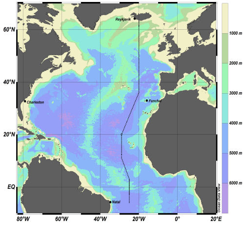
Fixed Station Information
Fixed Station Information
| Station Name | WOCE Station A16N |
| Category | Offshore route/traverse |
World Ocean Circulation Experiment (WOCE) Hydrographic Programme Section A16N
WOCE established a hydrographic section in the Atlantic, from Reykjavik, Iceland to Natal, Brazil, designated A16N. The station geographic boundaries are: 63° 17.58'N to 6° 0.64'S, 29° 00.00'W to 19° 59.99'W
History of Occupations at Section A16N
| Cruise | Date begins | Date ends | Country | PSO |
|---|---|---|---|---|
| R/V OCEANUS 202 | 23-07-1988 | 01-09-1988 | USA | M. McCartney |
| R/V Ronald H. Brown A16N_2003A | 04-06-2003 | 11-08-2003 | USA | J. Bullister |
| RRS Discovery D368 | 15-07-2011 | 04-08-2011 | United Kingdom | B. King |
| R/V Ronald H. Brown 13-04-2013 A16N | 16-07-2013 | 25-09-2013 | USA | M. Baringer / J. Bullister |
Related Fixed Station activities are detailed in Appendix 1
BODC Quality Control Flags
The following single character qualifying flags may be associated with one or more individual parameters with a data cycle:
| Flag | Description |
|---|---|
| Blank | Unqualified |
| < | Below detection limit |
| > | In excess of quoted value |
| A | Taxonomic flag for affinis (aff.) |
| B | Beginning of CTD Down/Up Cast |
| C | Taxonomic flag for confer (cf.) |
| D | Thermometric depth |
| E | End of CTD Down/Up Cast |
| G | Non-taxonomic biological characteristic uncertainty |
| H | Extrapolated value |
| I | Taxonomic flag for single species (sp.) |
| K | Improbable value - unknown quality control source |
| L | Improbable value - originator's quality control |
| M | Improbable value - BODC quality control |
| N | Null value |
| O | Improbable value - user quality control |
| P | Trace/calm |
| Q | Indeterminate |
| R | Replacement value |
| S | Estimated value |
| T | Interpolated value |
| U | Uncalibrated |
| W | Control value |
| X | Excessive difference |
SeaDataNet Quality Control Flags
The following single character qualifying flags may be associated with one or more individual parameters with a data cycle:
| Flag | Description |
|---|---|
| 0 | no quality control |
| 1 | good value |
| 2 | probably good value |
| 3 | probably bad value |
| 4 | bad value |
| 5 | changed value |
| 6 | value below detection |
| 7 | value in excess |
| 8 | interpolated value |
| 9 | missing value |
| A | value phenomenon uncertain |
| B | nominal value |
| Q | value below limit of quantification |
Appendix 1: WOCE Station A16N
Related series for this Fixed Station are presented in the table below. Further information can be found by following the appropriate links.
If you are interested in these series, please be aware we offer a multiple file download service. Should your credentials be insufficient for automatic download, the service also offers a referral to our Enquiries Officer who may be able to negotiate access.
| Series Identifier | Data Category | Start date/time | Start position | Cruise |
|---|---|---|---|---|
| 1851701 | Water sample data | 2011-07-20 05:39:00 | 49.0055 N, 19.9956 W | RRS Discovery D368 |
| 1137503 | CTD or STD cast | 2011-07-20 05:39:58 | 49.0055 N, 19.9956 W | RRS Discovery D368 |
| 1851713 | Water sample data | 2011-07-20 20:49:00 | 48.0253 N, 19.9941 W | RRS Discovery D368 |
| 1137515 | CTD or STD cast | 2011-07-20 20:49:16 | 48.0253 N, 19.9941 W | RRS Discovery D368 |
| 1851725 | Water sample data | 2011-07-21 07:13:00 | 47.0003 N, 19.9879 W | RRS Discovery D368 |
| 1137527 | CTD or STD cast | 2011-07-21 07:13:59 | 47.0003 N, 19.9879 W | RRS Discovery D368 |
| 1851737 | Water sample data | 2011-07-21 16:52:00 | 45.9897 N, 20.0014 W | RRS Discovery D368 |
| 1137539 | CTD or STD cast | 2011-07-21 16:52:29 | 45.9897 N, 20.0014 W | RRS Discovery D368 |
| 1851749 | Water sample data | 2011-07-22 02:25:00 | 45.0024 N, 20.0067 W | RRS Discovery D368 |
| 1137540 | CTD or STD cast | 2011-07-22 02:25:16 | 45.0024 N, 20.0067 W | RRS Discovery D368 |
| 1137552 | CTD or STD cast | 2011-07-22 12:45:36 | 44.0091 N, 20.0155 W | RRS Discovery D368 |
| 1851750 | Water sample data | 2011-07-22 14:36:00 | 44.0091 N, 20.0155 W | RRS Discovery D368 |
| 1851762 | Water sample data | 2011-07-22 20:30:00 | 43.003 N, 19.9911 W | RRS Discovery D368 |
| 1137564 | CTD or STD cast | 2011-07-22 20:30:14 | 43.003 N, 19.9911 W | RRS Discovery D368 |
| 1851774 | Water sample data | 2011-07-23 06:02:00 | 42.0475 N, 20.0009 W | RRS Discovery D368 |
| 1137576 | CTD or STD cast | 2011-07-23 06:02:23 | 42.0475 N, 20.0009 W | RRS Discovery D368 |
| 1137588 | CTD or STD cast | 2011-07-23 14:59:37 | 41.0009 N, 20.0086 W | RRS Discovery D368 |
| 1851798 | Water sample data | 2011-07-24 00:20:00 | 39.9944 N, 19.9832 W | RRS Discovery D368 |
| 1137607 | CTD or STD cast | 2011-07-24 00:20:06 | 39.9944 N, 19.9832 W | RRS Discovery D368 |
| 1851805 | Water sample data | 2011-07-24 09:34:00 | 38.998 N, 20.007 W | RRS Discovery D368 |
| 1137619 | CTD or STD cast | 2011-07-24 09:34:17 | 38.998 N, 20.007 W | RRS Discovery D368 |
| 1851817 | Water sample data | 2011-07-24 19:02:00 | 38.0117 N, 20.0023 W | RRS Discovery D368 |
| 1137620 | CTD or STD cast | 2011-07-24 19:02:09 | 38.0117 N, 20.0023 W | RRS Discovery D368 |
| 1851829 | Water sample data | 2011-07-25 06:43:00 | 36.8436 N, 20.0014 W | RRS Discovery D368 |
| 1137632 | CTD or STD cast | 2011-07-25 06:43:26 | 36.8436 N, 20.0014 W | RRS Discovery D368 |
| 1851830 | Water sample data | 2011-07-25 16:00:00 | 36.0092 N, 20.0106 W | RRS Discovery D368 |
| 1137644 | CTD or STD cast | 2011-07-25 16:00:50 | 36.0092 N, 20.0106 W | RRS Discovery D368 |
| 1851842 | Water sample data | 2011-07-26 02:36:00 | 35.003 N, 20.5454 W | RRS Discovery D368 |
| 1137656 | CTD or STD cast | 2011-07-26 02:36:47 | 35.003 N, 20.5454 W | RRS Discovery D368 |
| 1851854 | Water sample data | 2011-07-26 13:07:00 | 33.9991 N, 21.1263 W | RRS Discovery D368 |
| 1137668 | CTD or STD cast | 2011-07-26 13:07:29 | 33.9991 N, 21.1263 W | RRS Discovery D368 |
| 1851866 | Water sample data | 2011-07-26 23:56:00 | 33.01 N, 21.692 W | RRS Discovery D368 |
| 1137681 | CTD or STD cast | 2011-07-26 23:56:56 | 33.01 N, 21.692 W | RRS Discovery D368 |
| 1851878 | Water sample data | 2011-07-27 10:44:00 | 31.9972 N, 22.2491 W | RRS Discovery D368 |
| 1137693 | CTD or STD cast | 2011-07-27 10:44:40 | 31.9972 N, 22.2491 W | RRS Discovery D368 |
| 1851891 | Water sample data | 2011-07-27 20:45:00 | 31.0079 N, 22.8011 W | RRS Discovery D368 |
| 1137700 | CTD or STD cast | 2011-07-27 20:45:09 | 31.0079 N, 22.8011 W | RRS Discovery D368 |
| 1851909 | Water sample data | 2011-07-28 07:19:00 | 30.004 N, 23.3775 W | RRS Discovery D368 |
| 1137712 | CTD or STD cast | 2011-07-28 07:19:17 | 30.004 N, 23.3775 W | RRS Discovery D368 |
| 1851910 | Water sample data | 2011-07-28 17:42:00 | 28.9979 N, 23.9312 W | RRS Discovery D368 |
| 1137724 | CTD or STD cast | 2011-07-28 17:42:23 | 28.9979 N, 23.9312 W | RRS Discovery D368 |
| 1851922 | Water sample data | 2011-07-29 08:38:00 | 28.018 N, 24.507 W | RRS Discovery D368 |
| 1137736 | CTD or STD cast | 2011-07-29 08:38:21 | 28.018 N, 24.507 W | RRS Discovery D368 |
| 1851934 | Water sample data | 2011-07-29 19:18:00 | 26.9996 N, 25.0612 W | RRS Discovery D368 |
| 1137748 | CTD or STD cast | 2011-07-29 19:18:39 | 26.9996 N, 25.0612 W | RRS Discovery D368 |
| 1851946 | Water sample data | 2011-07-30 06:10:00 | 26.0015 N, 25.6236 W | RRS Discovery D368 |
| 1137761 | CTD or STD cast | 2011-07-30 06:10:32 | 26.0015 N, 25.6236 W | RRS Discovery D368 |
| 1851958 | Water sample data | 2011-07-30 16:08:00 | 24.9945 N, 26.1913 W | RRS Discovery D368 |
| 1137773 | CTD or STD cast | 2011-07-30 16:08:59 | 24.9945 N, 26.1913 W | RRS Discovery D368 |
| 1851971 | Water sample data | 2011-07-31 02:22:00 | 24.0008 N, 26.7593 W | RRS Discovery D368 |
| 1137785 | CTD or STD cast | 2011-07-31 02:22:21 | 24.0008 N, 26.7593 W | RRS Discovery D368 |
| 1851983 | Water sample data | 2011-07-31 10:51:00 | 23.3423 N, 27.1358 W | RRS Discovery D368 |
| 1137797 | CTD or STD cast | 2011-07-31 10:51:46 | 23.3423 N, 27.1358 W | RRS Discovery D368 |
