Metadata Report for BODC Series Reference Number 1973525
Metadata Summary
Problem Reports
Data Access Policy
Data Policy
Narrative Documents
Project Information
Data Activity or Cruise Information
Fixed Station Information
BODC Quality Flags
SeaDataNet Quality Flags
Metadata Summary
Data Description |
|||||||||||||||||||||||||||||||||||||||||||||
|
|||||||||||||||||||||||||||||||||||||||||||||
Data Identifiers |
|||||||||||||||||||||||||||||||||||||||||||||
|
|||||||||||||||||||||||||||||||||||||||||||||
Time Co-ordinates(UT) |
|||||||||||||||||||||||||||||||||||||||||||||
|
|||||||||||||||||||||||||||||||||||||||||||||
Spatial Co-ordinates | |||||||||||||||||||||||||||||||||||||||||||||
|
|||||||||||||||||||||||||||||||||||||||||||||
Parameters |
|||||||||||||||||||||||||||||||||||||||||||||
|
|||||||||||||||||||||||||||||||||||||||||||||
|
|||||||||||||||||||||||||||||||||||||||||||||
Problem Reports
No Problem Report Found in the Database
Data Access Policy
Western Boundary Time Series (WBTS) data access
The data from the Western Boundary Time Series (WBTS) project are freely available to all. The project scientists would appreciate it if the following acknowledgment was included in any publications that use this data;
"The Western Boundary Time Series data are made freely available by NOAA's Western Boundary Time Series project at https://www.aoml.noaa.gov/western-boundary-time-series/ and are funded by NOAA's Global Ocean Monitoring and Observing (GOMO) program."
Data Policy
Western Boundary Time Series (WBTS) data access
The data from the Western Boundary Time Series (WBTS) project are freely available to all. The project scientists would appreciate it if the following acknowledgment was included in any publications that use this data;
"The Western Boundary Time Series data are made freely available by NOAA's Western Boundary Time Series project at https://www.aoml.noaa.gov/western-boundary-time-series/ and are funded by NOAA's Global Ocean Monitoring and Observing (GOMO) program."
Narrative Documents
Sea-Bird Dissolved Oxygen Sensor SBE 43 and SBE 43F
The SBE 43 is a dissolved oxygen sensor designed for marine applications. It incorporates a high-performance Clark polarographic membrane with a pump that continuously plumbs water through it, preventing algal growth and the development of anoxic conditions when the sensor is taking measurements.
Two configurations are available: SBE 43 produces a voltage output and can be incorporated with any Sea-Bird CTD that accepts input from a 0-5 volt auxiliary sensor, while the SBE 43F produces a frequency output and can be integrated with an SBE 52-MP (Moored Profiler CTD) or used for OEM applications. The specifications below are common to both.
Specifications
| Housing | Plastic or titanium |
| Membrane | 0.5 mil- fast response, typical for profile applications 1 mil- slower response, typical for moored applications |
| Depth rating | 600 m (plastic) or 7000 m (titanium) 10500 m titanium housing available on request |
| Measurement range | 120% of surface saturation |
| Initial accuracy | 2% of saturation |
| Typical stability | 0.5% per 1000 h |
Further details can be found in the manufacturer's specification sheet.
Sea-Bird Electronics SBE 911 and SBE 917 series CTD profilers
The SBE 911 and SBE 917 series of conductivity-temperature-depth (CTD) units are used to collect hydrographic profiles, including temperature, conductivity and pressure as standard. Each profiler consists of an underwater unit and deck unit or SEARAM. Auxiliary sensors, such as fluorometers, dissolved oxygen sensors and transmissometers, and carousel water samplers are commonly added to the underwater unit.
Underwater unit
The CTD underwater unit (SBE 9 or SBE 9 plus) comprises a protective cage (usually with a carousel water sampler), including a main pressure housing containing power supplies, acquisition electronics, telemetry circuitry, and a suite of modular sensors. The original SBE 9 incorporated Sea-Bird's standard modular SBE 3 temperature sensor and SBE 4 conductivity sensor, and a Paroscientific Digiquartz pressure sensor. The conductivity cell was connected to a pump-fed plastic tubing circuit that could include auxiliary sensors. Each SBE 9 unit was custom built to individual specification. The SBE 9 was replaced in 1997 by an off-the-shelf version, termed the SBE 9 plus, that incorporated the SBE 3 plus (or SBE 3P) temperature sensor, SBE 4C conductivity sensor and a Paroscientific Digiquartz pressure sensor. Sensors could be connected to a pump-fed plastic tubing circuit or stand-alone.
Temperature, conductivity and pressure sensors
The conductivity, temperature, and pressure sensors supplied with Sea-Bird CTD systems have outputs in the form of variable frequencies, which are measured using high-speed parallel counters. The resulting count totals are converted to numeric representations of the original frequencies, which bear a direct relationship to temperature, conductivity or pressure. Sampling frequencies for these sensors are typically set at 24 Hz.
The temperature sensing element is a glass-coated thermistor bead, pressure-protected inside a stainless steel tube, while the conductivity sensing element is a cylindrical, flow-through, borosilicate glass cell with three internal platinum electrodes. Thermistor resistance or conductivity cell resistance, respectively, is the controlling element in an optimized Wien Bridge oscillator circuit, which produces a frequency output that can be converted to a temperature or conductivity reading. These sensors are available with depth ratings of 6800 m (aluminium housing) or 10500 m (titanium housing). The Paroscientific Digiquartz pressure sensor comprises a quartz crystal resonator that responds to pressure-induced stress, and temperature is measured for thermal compensation of the calculated pressure.
Additional sensors
Optional sensors for dissolved oxygen, pH, light transmission, fluorescence and others do not require the very high levels of resolution needed in the primary CTD channels, nor do these sensors generally offer variable frequency outputs. Accordingly, signals from the auxiliary sensors are acquired using a conventional voltage-input multiplexed A/D converter (optional). Some Sea-Bird CTDs use a strain gauge pressure sensor (Senso-Metrics) in which case their pressure output data is in the same form as that from the auxiliary sensors as described above.
Deck unit or SEARAM
Each underwater unit is connected to a power supply and data logging system: the SBE 11 (or SBE 11 plus) deck unit allows real-time interfacing between the deck and the underwater unit via a conductive wire, while the submersible SBE 17 (or SBE 17 plus) SEARAM plugs directly into the underwater unit and data are downloaded on recovery of the CTD. The combination of SBE 9 and SBE 17 or SBE 11 are termed SBE 917 or SBE 911, respectively, while the combinations of SBE 9 plus and SBE 17 plus or SBE 11 plus are termed SBE 917 plus or SBE 911 plus.
Specifications
Specifications for the SBE 9 plus underwater unit are listed below:
| Parameter | Range | Initial accuracy | Resolution at 24 Hz | Response time |
|---|---|---|---|---|
| Temperature | -5 to 35°C | 0.001°C | 0.0002°C | 0.065 sec |
| Conductivity | 0 to 7 S m-1 | 0.0003 S m-1 | 0.00004 S m-1 | 0.065 sec (pumped) |
| Pressure | 0 to full scale (1400, 2000, 4200, 6800 or 10500 m) | 0.015% of full scale | 0.001% of full scale | 0.015 sec |
Further details can be found in the manufacturer's specification sheet.
EN598 CTD Originator's Data Processing
Sampling strategy
In total, 44 CTD stations were completed on cruise EN598 to produce full depth vertical profiles of temperature, salinity and dissolved oxygen concentration. In addition, Lowered Acoustic Doppler Current Profilers (LADCPs) were attached to the CTD frame. CTDs were performed at stations along the 26.5N transect from 69.5W towards Abaco Island, a section across the Northwest Providence Channel and a section across the Straits of Florida at 27N.
Data Acquisition and Initial Processing
A description of all the instruments on the CTD frame, including serial numbers can be found on page 12 of Hooper and Baringer (2018).
The data were processed using Sea-Bird SBE data processing and AOML Matlab processing software. The temperature, conductivity and dissolved oxygen sensors were calibrated post-cruise against independent discrete samples taken from water bottles attached to the CTD frame. Of the pairs of sensors, it was determined that the primary sensors behaved more stably and are the ones included in the final data files. Further details on the processing and calibrations can be found in Hooper and Baringer (2018).
The processed data were supplied to BODC for banking.
References
Hooper, J.A., and Baringer, M.O. (2018). Hydrographic measurements collected aboard the UNOLS ship R/V Endeavor, 8 May - 24 May 2017: Western Boundary Time Series Cruise EN598 (AB1705) NOAA Data Report, OAR-AOML-75 Atlantic Oceanographic and Meteorological Laboratory, Miami, FL. doi:10.25923/rszb-p579
WBTS Hydrography BODC data processing
The data arrived at BODC in ASCII files representing individual CTD casts. The data contained in the files are the downcast data averaged to a 1db pressure grid. The casts were reformatted to BODC's internal NetCDF format. The following table shows the mapping of variables within the ASCII files to appropriate BODC parameter codes
| Originator's Variable | Originator's Units | Description | BODC Parameter Code | Units | Comments |
|---|---|---|---|---|---|
| te | deg C | Temperature of the water body by CTD or STD | TEMPST01 | °C | - |
| sa | psu | Practical salinity of the water body by CTD and computation using UNESCO 1983 algorithm | PSALST01 | - | - |
| gamma | ga | Depth below surface of the water body by profiling pressure sensor and converted to seawater depth using UNESCO algorithm | DEPHPR01 | m | - |
| p | dbar | Pressure (spatial co-ordinate) exerted by the water body by profiling pressure sensor and corrected to read zero at sea level | PRESPR01 | dbar | - |
| ox | µmol/kg | Concentration of oxygen {O2} per unit volume of the water body [dissolved plus reactive particulate phase] by Sea-Bird SBE 43 sensor and calibration against sample data | DOXYSC01 | µmol l-1 | Conversion by BODC to µmol l-1 using TOKGPR01 |
| - | - | Saturation of oxygen {O2} in the water body [dissolved plus reactive particulate phase] | OXYSZZ01 | % | Derived by BODC using DOXYSC01, TEMPST01 and PSALST01 |
| - | - | Potential temperature of the water body by computation using unesco 1983 algorithm | POTMCV01 | °C | Derived by BODC using TEMPST01, PSALST01 and PRESPR01. |
| - | - | Sigma-theta of the water body by CTD and computation from salinity and potential temperature using UNESCO algorithm | SIGTPR01 | kg m-3 | Derived by BODC using POTMCV01, PSALST01 and PRESPR01 |
| - | - | Conversion factor (volume to mass) for the water body by CTD and computation of density (in-situ potential temperature surface pressure) reciprocal from pressure, temperature and salinity | TOKGPR01 | l kg-1 | Derived by BODC using SIGTPR01 |
The reformatted data were visualised using the in-house EDSERPLO software. Suspect data were marked by adding an appropriate quality control flag, and missing data marked by setting both the data to an appropriate value and setting the quality control flag.
Detailed metadata and documentation were compiled and linked to the data.
Project Information
Western Boundary Time Series (WBTS) in the Atlantic Ocean
Introduction
Users of these data are referred to the Western Boundary Time Series (WBTS) in the Atlantic Ocean website for more information. The following text has been taken from the website.
Scientific Rationale
Climate models have shown that variations of the transport of the Meridional Overturning Cell (MOC) in the Atlantic Ocean have significant impacts on the climate at both the national and global level. In the subtropical North Atlantic, the meridional overturning circulation consists primarily of two western boundary components: the northward flowing Gulf Stream and the southward flowing Deep Western Boundary Current.
The Gulf Stream is the strong surface intensified flow along the east coast of the United States that brings warm waters of tropical, including carbon, nutrients and fish, origin along the eastern seaboard of the United States. It supplies warm waters along the coast that impact a multitude of important climate phenomena including hurricane intensification, winter storm formation and moderate European weather. The Gulf Stream includes the bulk of what we call the upper limb of the thermohaline circulation in the subtropical Atlantic, in addition to a strong wind-driven flow. As the Gulf Stream flows northward, it loses heat to the atmosphere until eventually in the subpolar North Atlantic some of it becomes cold enough to sink to the bottom of the ocean. This cold deep water then returns southward along the continental slope of the eastern United States as the Deep Western Boundary Current, completing the circuit of the overturning circulation.
Off the coast of Florida, the Gulf Stream is referred to as the Florida Current and is fortuitously confined within the limited geographic channel between Florida and the Bahamas Islands, thus making a long-term observing system cost effective and sustainable. Similarly, the Deep Western Boundary Current is located within several hundred miles to the east of the Abaco Island, Grand Bahamas. The convenient geometry of the Bahamas Island chain thus allows an effective choke point for establishing a long term monitoring program of this deep limb of the overturning circulation.
Overview
The project consists of several components to monitor the Western Boundary currents in the subtropical Atlantic:
- Florida Cable Transport Time Series - Measuring the voltage difference across the Straits of Florida using submerged submarine telephone cables
- Florida Current Cruises - Eight small-boat cruises involving dropsonde and XBT measurements and four research vessel cruises using CTD and LADCP measurements are taken annually across the Florida Current.
- Deep Western Boundary Current Hydrography - Two hydrographic cruises per year across the Deep Western Boundary Current (DWBC) area, east of Abaco Island, to measure water mass properties and transports.
- Deep Western Boundary Current Transport Time Series - A monitoring system for the Deep Western Boundary Current using inverted echo sounders, bottom pressure gauges, and one deep current meter
Deep Western Boundary Current (DWBC) Hydrography
Introduction
Users of these data are referred to the Deep Western Boundary Current (DWBC) Hydrography website for more information. The following text has been taken from the website.
Scientific Rationale
Climate models have shown that variations of the transport of the Meridional Overturning Cell (MOC) in the Atlantic Ocean have significant impacts on the climate at both the national and global level. In the subtropical North Atlantic, the meridional overturning circulation consists primarily of two western boundary components: the northward flowing Gulf Stream and the southward flowing Deep Western Boundary Current.
The Gulf Stream is the strong surface intensified flow along the east coast of the United States that brings warm waters of tropical, including carbon, nutrients and fish, origin along the eastern seaboard of the United States. It supplies warm waters along the coast that impact a multitude of important climate phenomena including hurricane intensification, winter storm formation and moderate European weather. The Gulf Stream includes the bulk of what we call the upper limb of the thermohaline circulation in the subtropical Atlantic, in addition to a strong wind-driven flow. As the Gulf Stream flows northward, it loses heat to the atmosphere until eventually in the subpolar North Atlantic some of it becomes cold enough to sink to the bottom of the ocean. This cold deep water then returns southward along the continental slope of the eastern United States as the Deep Western Boundary Current, completing the circuit of the overturning circulation.
Off the coast of Florida, the Gulf Stream is referred to as the Florida Current and is fortuitously confined within the limited geographic channel between Florida and the Bahamas Islands, thus making a long-term observing system cost effective and sustainable. Similarly, the Deep Western Boundary Current is located within several hundred miles to the east of the Abaco Island, Grand Bahamas. The convenient geometry of the Bahamas Island chain thus allows an effective choke point for establishing a long term monitoring program of this deep limb of the overturning circulation.
Overview
Over the past 20 years a variety of snapshot sections and time series moorings have been placed along the continental slope east of Abaco Island, Grand Bahamas, in order to monitor variability of the transport carried by the Deep Western Boundary Current. The Abaco time series began in August 1984 when the NOAA Subtropical Atlantic Climate Studies Program extended its Straits of Florida program to include measurements of western boundary current transports and water mass properties east of Abaco Island, Grand Bahamas. Since 1986, over 20 hydrographic sections have been completed east of Abaco, most including direct velocity observations, and salinity and oxygen bottle samples. Many sections have also included carbon, chlorofluorocarbon, and other tracers.
Stations frequently visited during the Deep Western Boundary Current Hydrography cruise 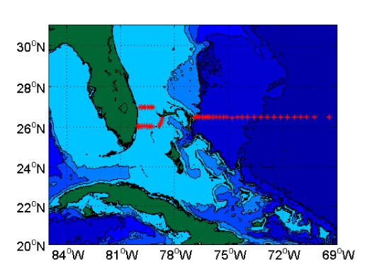
The repeated hydrographic and tracer sampling at Abaco has established a high-resolution record of water mass properties in the Deep Western Boundary Current at 26N. Events such as the intense convection period in the Labrador Sea and the renewal of classical Labrador Sea Water in the 1980's are clearly reflected in the cooling and freshening of the Deep Western Boundary Current waters off Abaco, and the arrival of a strong chlorofluorocarbon pulse approximately 10 years later. This data set is unique in that it is not just a single time series site but a transport section, of which very few are available in the ocean that approach a decade in length.
These continued time series observations at Abaco are seen as serving three main purposes for climate variability studies:
- Monitoring of the DWBC for water mass and transport signatures related to changes in the strengths and regions of high latitude water mass formation in the North Atlantic for the ultimate purpose of assessing rapid climate change.
- Serving as a western boundary endpoint of a subtropical meridional overturning circulation (MOC)/heat flux monitoring system designed to measure the interior dynamic height difference across the entire Atlantic basin and its associated baroclinic heat transport.
- Monitoring the intensity of the Antilles Current as an index (together with the Florida Current) of interannual variability in the strength of the subtropical gyre.
Data Activity or Cruise Information
Cruise
| Cruise Name | EN598 |
| Departure Date | 2017-05-08 |
| Arrival Date | 2017-05-24 |
| Principal Scientist(s) | William E Johns (Rosenstiel School of Marine and Atmospheric Science) |
| Ship | RV Endeavor |
Complete Cruise Metadata Report is available here
Fixed Station Information
Fixed Station Information
| Station Name | WBTS Northwest Providence Channel section |
| Category | Offshore route/traverse |
WBTS Northwest Providence Channel section
The Western Boundary Time Series (WBTS) Northwest Providence Channel section is one of four hydrographic sections of the WBTS Hydrography project.
The Northwest Providence Channel section extends from Freeport, Grand Bahamas south-westwards across the Northwest Providence Channel. The measurements made along the section lie within a box bounded by co-ordinates 26°N, 78.9°W at the south west corner and 26.5°N 78.6°W at the north east corner. The section was first occupied in 1984 and continues to be occupied at least once a year.
Most sections have included measurements of temperature, salinity, oxygen and direct current velocities.
The figure below shows a typical section with stations marked with black circles.
Map of stations
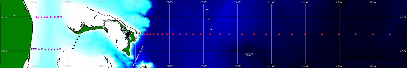
Map showing typical locations of stations that make up the WBTS hydrographic sections. Red triangles depict the Abaco section, black circles depict Northwest Providence Channel section, magenta squares depict the North Florida Straits section and purple triangles denote South Florida Straits section.
Related Fixed Station activities are detailed in Appendix 1
BODC Quality Control Flags
The following single character qualifying flags may be associated with one or more individual parameters with a data cycle:
| Flag | Description |
|---|---|
| Blank | Unqualified |
| < | Below detection limit |
| > | In excess of quoted value |
| A | Taxonomic flag for affinis (aff.) |
| B | Beginning of CTD Down/Up Cast |
| C | Taxonomic flag for confer (cf.) |
| D | Thermometric depth |
| E | End of CTD Down/Up Cast |
| G | Non-taxonomic biological characteristic uncertainty |
| H | Extrapolated value |
| I | Taxonomic flag for single species (sp.) |
| K | Improbable value - unknown quality control source |
| L | Improbable value - originator's quality control |
| M | Improbable value - BODC quality control |
| N | Null value |
| O | Improbable value - user quality control |
| P | Trace/calm |
| Q | Indeterminate |
| R | Replacement value |
| S | Estimated value |
| T | Interpolated value |
| U | Uncalibrated |
| W | Control value |
| X | Excessive difference |
SeaDataNet Quality Control Flags
The following single character qualifying flags may be associated with one or more individual parameters with a data cycle:
| Flag | Description |
|---|---|
| 0 | no quality control |
| 1 | good value |
| 2 | probably good value |
| 3 | probably bad value |
| 4 | bad value |
| 5 | changed value |
| 6 | value below detection |
| 7 | value in excess |
| 8 | interpolated value |
| 9 | missing value |
| A | value phenomenon uncertain |
| B | nominal value |
| Q | value below limit of quantification |
Appendix 1: WBTS Northwest Providence Channel section
Related series for this Fixed Station are presented in the table below. Further information can be found by following the appropriate links.
If you are interested in these series, please be aware we offer a multiple file download service. Should your credentials be insufficient for automatic download, the service also offers a referral to our Enquiries Officer who may be able to negotiate access.
| Series Identifier | Data Category | Start date/time | Start position | Cruise |
|---|---|---|---|---|
| 1742340 | CTD or STD cast | 2009-05-01 21:33:00 | 26.433 N, 78.667 W | NOAA Ship Ronald H. Brown RB0901 |
| 1742352 | CTD or STD cast | 2009-05-01 23:38:00 | 26.346 N, 78.711 W | NOAA Ship Ronald H. Brown RB0901 |
| 1742364 | CTD or STD cast | 2009-05-02 01:43:00 | 26.25 N, 78.767 W | NOAA Ship Ronald H. Brown RB0901 |
| 1742376 | CTD or STD cast | 2009-05-02 03:06:00 | 26.166 N, 78.8 W | NOAA Ship Ronald H. Brown RB0901 |
| 1742388 | CTD or STD cast | 2009-05-02 05:08:00 | 26.067 N, 78.849 W | NOAA Ship Ronald H. Brown RB0901 |
| 1760021 | CTD or STD cast | 2009-11-22 01:34:00 | 26.432 N, 78.664 W | RRS Discovery D345 |
| 1760033 | CTD or STD cast | 2009-11-22 03:56:00 | 26.333 N, 78.719 W | RRS Discovery D345 |
| 1760045 | CTD or STD cast | 2009-11-22 05:46:00 | 26.253 N, 78.767 W | RRS Discovery D345 |
| 1760057 | CTD or STD cast | 2009-11-22 07:21:00 | 26.171 N, 78.8 W | RRS Discovery D345 |
| 1760069 | CTD or STD cast | 2009-11-22 09:01:00 | 26.065 N, 78.85 W | RRS Discovery D345 |
| 1815275 | CTD or STD cast | 2010-04-15 04:28:00 | 26.067 N, 78.851 W | RV Oceanus OC459-2 |
| 1815287 | CTD or STD cast | 2010-04-15 05:52:00 | 26.167 N, 78.8 W | RV Oceanus OC459-2 |
| 1815299 | CTD or STD cast | 2010-04-15 07:08:00 | 26.252 N, 78.769 W | RV Oceanus OC459-2 |
| 1815306 | CTD or STD cast | 2010-04-15 08:25:00 | 26.334 N, 78.72 W | RV Oceanus OC459-2 |
| 1815318 | CTD or STD cast | 2010-04-15 09:54:00 | 26.434 N, 78.669 W | RV Oceanus OC459-2 |
| 1358048 | CTD or STD cast | 2011-04-13 21:11:00 | 26.432 N, 78.668 W | RV Knorr KN200-4 |
| 1358061 | CTD or STD cast | 2011-04-13 23:26:00 | 26.333 N, 78.717 W | RV Knorr KN200-4 |
| 1358073 | CTD or STD cast | 2011-04-14 01:03:00 | 26.25 N, 78.767 W | RV Knorr KN200-4 |
| 1358085 | CTD or STD cast | 2011-04-14 02:30:00 | 26.165 N, 78.8 W | RV Knorr KN200-4 |
| 1358097 | CTD or STD cast | 2011-04-14 03:51:00 | 26.066 N, 78.849 W | RV Knorr KN200-4 |
| 1358988 | CTD or STD cast | 2012-03-01 14:54:00 | 26.434 N, 78.667 W | NOAA Ship Ronald H. Brown RB1201 |
| 1359003 | CTD or STD cast | 2012-03-01 17:01:00 | 26.336 N, 78.716 W | NOAA Ship Ronald H. Brown RB1201 |
| 1359015 | CTD or STD cast | 2012-03-01 20:06:00 | 26.249 N, 78.763 W | NOAA Ship Ronald H. Brown RB1201 |
| 1359027 | CTD or STD cast | 2012-03-01 21:23:00 | 26.166 N, 78.8 W | NOAA Ship Ronald H. Brown RB1201 |
| 1359039 | CTD or STD cast | 2012-03-01 22:55:00 | 26.067 N, 78.85 W | NOAA Ship Ronald H. Brown RB1201 |
| 1359273 | CTD or STD cast | 2012-09-25 02:25:00 | 26.071 N, 78.852 W | RV Endeavor EN517 |
| 1359285 | CTD or STD cast | 2012-09-25 04:33:00 | 26.169 N, 78.802 W | RV Endeavor EN517 |
| 1359297 | CTD or STD cast | 2012-09-25 06:27:00 | 26.251 N, 78.766 W | RV Endeavor EN517 |
| 1359304 | CTD or STD cast | 2012-09-25 08:17:00 | 26.318 N, 78.715 W | RV Endeavor EN517 |
| 1359316 | CTD or STD cast | 2012-09-25 10:26:00 | 26.434 N, 78.669 W | RV Endeavor EN517 |
| 1357371 | CTD or STD cast | 2014-03-30 02:32:00 | 26.065 N, 78.849 W | RV Atlantic Explorer AE1404 |
| 1357383 | CTD or STD cast | 2014-03-30 03:41:00 | 26.166 N, 78.8 W | RV Atlantic Explorer AE1404 |
| 1357395 | CTD or STD cast | 2014-03-30 05:07:00 | 26.252 N, 78.771 W | RV Atlantic Explorer AE1404 |
| 1357402 | CTD or STD cast | 2014-03-30 06:25:00 | 26.334 N, 78.718 W | RV Atlantic Explorer AE1404 |
| 1357414 | CTD or STD cast | 2014-03-30 07:55:00 | 26.436 N, 78.659 W | RV Atlantic Explorer AE1404 |
| 1877040 | CTD or STD cast | 2015-10-17 15:59:00 | 26.434 N, 78.666 W | RV Endeavor EN570 |
| 1877052 | CTD or STD cast | 2015-10-17 17:30:00 | 26.335 N, 78.715 W | RV Endeavor EN570 |
| 1877064 | CTD or STD cast | 2015-10-17 18:49:00 | 26.253 N, 78.764 W | RV Endeavor EN570 |
| 1877076 | CTD or STD cast | 2015-10-17 20:30:00 | 26.168 N, 78.799 W | RV Endeavor EN570 |
| 1877088 | CTD or STD cast | 2015-10-17 21:22:00 | 26.069 N, 78.848 W | RV Endeavor EN570 |
| 1973224 | CTD or STD cast | 2016-02-26 18:11:00 | 26.068 N, 78.852 W | RV Endeavor EN574 |
| 1973236 | CTD or STD cast | 2016-02-26 19:28:00 | 26.166 N, 78.805 W | RV Endeavor EN574 |
| 1973248 | CTD or STD cast | 2016-02-26 20:54:00 | 26.25 N, 78.769 W | RV Endeavor EN574 |
| 1973261 | CTD or STD cast | 2016-02-26 22:13:00 | 26.333 N, 78.716 W | RV Endeavor EN574 |
| 1973273 | CTD or STD cast | 2016-02-26 23:56:00 | 26.433 N, 78.671 W | RV Endeavor EN574 |
| 1973501 | CTD or STD cast | 2017-05-08 21:48:00 | 26.064 N, 78.851 W | RV Endeavor EN598 |
| 1973513 | CTD or STD cast | 2017-05-08 23:29:00 | 26.162 N, 78.799 W | RV Endeavor EN598 |
| 1973537 | CTD or STD cast | 2017-05-09 02:30:00 | 26.337 N, 78.714 W | RV Endeavor EN598 |
| 1973549 | CTD or STD cast | 2017-05-09 03:52:00 | 26.437 N, 78.671 W | RV Endeavor EN598 |
