BODC Cruise Metadata Report for RV Corystes (74RY) cruise COR7/98
Introduction
This report collates information from the BODC cruise inventory and oceanographic databases. It presents
- Cruise Inventory Information
- A summary of BODC data holdings for the cruise from the
- References - including cruise tracks and cruise reports
Cruise Inventory Information
| Long name | RV Corystes (74RY) cruise COR7/98 |
|---|---|
| Short name | COR7/98 |
| Objectives and Narrative |
Locality: Part 1 - North East coast and Thames (approximately 03 - 10 July)
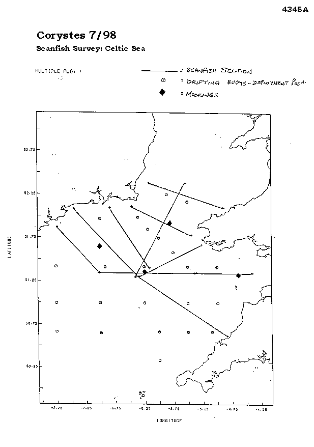
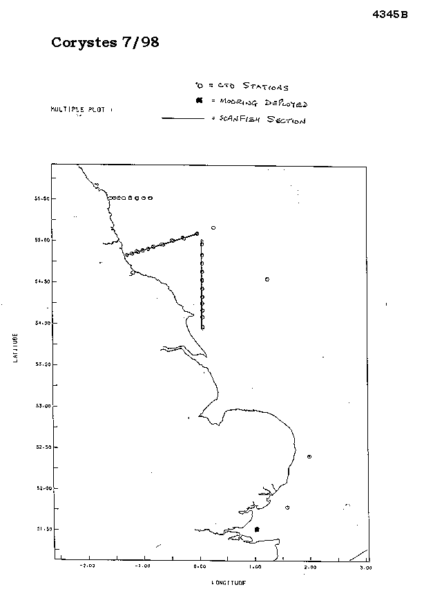
Part 2 - St. George's Channel and Celtic Sea (approximately 10 - 24 July) Part 1 is directed at a better understanding of the dynamics of the circulation processes fringing the north east coast of England, between the Firth of Forth and Flamborough Head, and in vicinity of the Dogger Bank. It is intended to characterise the extent and nature of the density driven and seasonal jet-like circulation which, from previous work in the Irish Sea and limited historical data, we believe acts as a direct and rapid pathway for transport of material from the coastal region to the central North Sea. Subsequently, the knowledge will be viewed with respect to concerns that elevated levels of contaminants on the Dogger Bank have originated in the near coastal region. In addition, several moorings in the vicinity of the Thames will be serviced as part of the Climatic Status of UK Coastal waters programme. Part 2 is directed at a better understanding of the dynamics of the circulation processes in the Celtic Sea/St. George's Channel region. As on the north east coast, it is intended to characterise the extent and nature of the seasonal density driven circulation. The main sampling aims of the cruise were: 1. To undertake Scanfish, CTD and grab surveys of the North East coast to collect information on nutrients, suspended sediment and metals. 2. To service two moorings in the vicinity of the Thames. 3. To deploy four mooring arrays in the Celtic Sea/St. George's Channel. 4. To deploy free floating satellite tracked buoys in the Celtic Sea/St. George's Channel in order to determine the Lagrangian circulation. 5. To undertake associated physical and chemical surveys of the region in support of 3) and 4). |
| Ship | RV Corystes |
| Departure Port | Lowestoft, United Kingdom |
| Departure Date | 1998-07-03 |
| Arrival Port | Lowestoft, United Kingdom |
| Arrival Date | 1998-07-24 |
| Principal Scientist(s) | Juan Brown (Centre for Environment, Fisheries and Aquaculture Science Lowestoft Laboratory) |
| Responsible Organisation | Centre for Environment, Fisheries and Aquaculture Science Lowestoft Laboratory |
| Associated Project(s) | |
| IHB Sea Areas Visited | North Sea, Celtic Sea |
| Marsden Squares Visited | 181/216 |
| Work Area Description | Part 1 NE coast and Thames, Part 2 St George's Channel and Celtic Sea |
| Unable to lookup cruise bounds at this time | |
| Work Area Bounding Polygon | |
| Southern Limit | unknown |
| Northern Limit | unknown |
| Western Limit | unknown |
| Eastern Limit | unknown |
Cruise Inventory Datasets
| Physical oceanography | |
|---|---|
| CTD stations |
Quantity:
number of stations =
37
Description: CTD profiles using FSI CTD; turbidity and fluorescence sensors fitted, plus underwater light intensity |
| Current profiler (eg ADCP) |
Quantity:
activity duration in days =
20
Description: Underway current profiling using RDI ADCP |
| Optics (eg underwater light levels) |
Quantity:
number of stations =
37
Description: CTD profiles using FSI CTD; turbidity and fluorescence sensors fitted, plus underwater light intensity |
| Optics (eg underwater light levels) |
Quantity:
track kilometres =
1200
Description: CTD mounted in GMI scanfish, undulating towed body, with fluorometer and underwater light intensity sensor |
| Subsurface temperature and salinity measurements |
Quantity:
track kilometres =
1200
Description: CTD mounted in GMI scanfish, undulating towed body, with fluorometer and underwater light intensity sensor |
| Surface measurements underway (T,S) |
Quantity:
activity duration in days =
20
Description: Underway near-surface temperature and salinity measurements |
| Water bottle stations |
Quantity:
number of stations =
59
Description: Multi-sampler used on up-casts at CTD stations - calibration samples for salinity, plus samples for nutrients (toxn, NO2, PO4, SIO4, NH4), suspended load + chlorophyll - additional samples for metals analysis - 'surface only' samples at some stations |
| Chemical oceanography | |
| Ammonia |
Quantity:
number of stations =
59
Description: Multi-sampler used on up-casts at CTD stations - calibration samples for salinity, plus samples for nutrients (toxn, NO2, PO4, SIO4, NH4), suspended load + chlorophyll - additional samples for metals analysis - 'surface only' samples at some stations |
| Ammonia |
Quantity:
number of samples =
88
Description: Near-surface samples for nutrients and chlorophyll - analysis along scanfish sections - also salinity for calibration |
| Nitrate |
Quantity:
number of samples =
88
Description: Near-surface samples for nutrients and chlorophyll - analysis along scanfish sections - also salinity for calibration |
| Nitrate |
Quantity:
number of stations =
59
Description: Multi-sampler used on up-casts at CTD stations - calibration samples for salinity, plus samples for nutrients (toxn, NO2, PO4, SIO4, NH4), suspended load + chlorophyll - additional samples for metals analysis - 'surface only' samples at some stations |
| Phosphate |
Quantity:
number of samples =
88
Description: Near-surface samples for nutrients and chlorophyll - analysis along scanfish sections - also salinity for calibration |
| Phosphate |
Quantity:
number of stations =
59
Description: Multi-sampler used on up-casts at CTD stations - calibration samples for salinity, plus samples for nutrients (toxn, NO2, PO4, SIO4, NH4), suspended load + chlorophyll - additional samples for metals analysis - 'surface only' samples at some stations |
| Silicate |
Quantity:
number of samples =
88
Description: Near-surface samples for nutrients and chlorophyll - analysis along scanfish sections - also salinity for calibration |
| Contamination | |
| Suspended matter |
Quantity:
number of stations =
37
Description: CTD profiles using FSI CTD; turbidity and fluorescence sensors fitted, plus underwater light intensity |
| Suspended matter |
Quantity:
number of stations =
59
Description: Multi-sampler used on up-casts at CTD stations - calibration samples for salinity, plus samples for nutrients (toxn, NO2, PO4, SIO4, NH4), suspended load + chlorophyll - additional samples for metals analysis - 'surface only' samples at some stations |
| Trace metals |
Quantity:
number of cores =
20
Description: Cores for trace metals analysis |
| Biology and fisheries | |
| Phytoplankton pigs (eg chlorophyll, fluorescence) |
Quantity:
number of stations =
37
Description: CTD profiles using FSI CTD; turbidity and fluorescence sensors fitted, plus underwater light intensity |
| Phytoplankton pigs (eg chlorophyll, fluorescence) |
Quantity:
number of samples =
88
Description: Near-surface samples for nutrients and chlorophyll - analysis along scanfish sections - also salinity for calibration |
| Phytoplankton pigs (eg chlorophyll, fluorescence) |
Quantity:
track kilometres =
1200
Description: CTD mounted in GMI scanfish, undulating towed body, with fluorometer and underwater light intensity sensor |
| Phytoplankton pigs (eg chlorophyll, fluorescence) |
Quantity:
number of stations =
59
Description: Multi-sampler used on up-casts at CTD stations - calibration samples for salinity, plus samples for nutrients (toxn, NO2, PO4, SIO4, NH4), suspended load + chlorophyll - additional samples for metals analysis - 'surface only' samples at some stations |
| Geology and geophysics | |
| Core - soft bottom |
Quantity:
number of cores =
20
Description: Cores for trace metals analysis |
Cruise Inventory Mooring/Buoy Operations
| Latitude | Longitude | Data type | Description |
|---|---|---|---|
| 51° 19' N | 4° 45' W | Current meters | Mooring 'K' deployed with three current meters - two with temperature, conductivity and pressure sensors - one with a turbidity sensor |
| 51° 31' N | 1° 1' E | Current meters | Mooring with biophysical sensors deployed - includes equipment to collect water samples and one current meter (with T + C sensors) |
| 51° 31' N | 1° 1' E | Current meters | Mooring with single current meter, fitted with temperature and conductivity sensors recovered (deployed May 1998) |
| 51° 55' N | 5° 48' W | Current profiler (eg ADCP) | Mooring with RDI 'Workhorse' ADCP deployed |
| 51° 40' N | 7° 0' W | Current profiler (eg ADCP) | Mooring with RDI 'Workhorse' ADCP deployed |
| 51° 22' N | 6° 15' W | Current profiler (eg ADCP) | Mooring with RDI 'Workhorse' ADCP deployed |
| 51° 22' N | 6° 15' W | Current profiler (eg ADCP) | Mooring with RDI 'Workhorse' ADCP recovered (deployed earlier during cruise) |
| 51° 31' N | 1° 1' E | Nitrate | Mooring with biophysical sensors deployed - includes equipment to collect water samples and one current meter (with T + C sensors) |
| 51° 31' N | 1° 1' E | Nitrate | Mooring with biophysical sensors recovered (deployed June 1998) |
| 51° 46' N | 1° 36' E | Nitrate | Mooring with biophysical sensors recovered (deployed June 1998) |
| 51° 31' N | 1° 1' E | Optics (eg underwater light levels) | Mooring with biophysical sensors deployed - includes equipment to collect water samples and one current meter (with T + C sensors) |
| 51° 31' N | 1° 1' E | Optics (eg underwater light levels) | Mooring with biophysical sensors recovered (deployed June 1998) |
| 51° 31' N | 1° 1' E | Phytoplankton pigs (eg chlorophyll, fluorescence) | Mooring with biophysical sensors deployed - includes equipment to collect water samples and one current meter (with T + C sensors) |
| 51° 31' N | 1° 1' E | Phytoplankton pigs (eg chlorophyll, fluorescence) | Mooring with biophysical sensors recovered (deployed June 1998) |
| 51° 46' N | 1° 36' E | Phytoplankton pigs (eg chlorophyll, fluorescence) | Mooring with biophysical sensors recovered (deployed June 1998) |
| 50° 39' N | 7° 0' W | Surface drifters/drifting buoys | Surface buoys tracked via Argos satellite and attached to drogue at approximately 30m depth (deployed 13/07/1998) |
| 51° 0' N | 7° 0' W | Surface drifters/drifting buoys | Surface buoys tracked via Argos satellite and attached to drogue at approximately 30m depth (deployed 14/07/1998) |
| 51° 25' N | 7° 45' W | Surface drifters/drifting buoys | Surface buoys tracked via Argos satellite and attached to drogue at approximately 30m depth (deployed 14/07/1998) |
| 51° 25' N | 6° 55' W | Surface drifters/drifting buoys | Surface buoys tracked via Argos satellite and attached to drogue at approximately 30m depth (deployed 14/07/1998) |
| 51° 0' N | 7° 45' W | Surface drifters/drifting buoys | Surface buoys tracked via Argos satellite and attached to drogue at approximately 30m depth (deployed 14/07/1998) |
| 50° 40' N | 7° 45' W | Surface drifters/drifting buoys | Surface buoys tracked via Argos satellite and attached to drogue at approximately 30m depth (deployed 14/07/1998) |
| 51° 25' N | 5° 0' W | Surface drifters/drifting buoys | Surface buoys tracked via Argos satellite and attached to drogue at approximately 30m depth (deployed 15/07/1998) |
| 51° 0' N | 4° 58' W | Surface drifters/drifting buoys | Surface buoys tracked via Argos satellite and attached to drogue at approximately 30m depth (deployed 15/07/1998) |
| 51° 25' N | 5° 30' W | Surface drifters/drifting buoys | Surface buoys tracked via Argos satellite and attached to drogue at approximately 30m depth (deployed 15/07/1998) |
| 51° 0' N | 5° 30' W | Surface drifters/drifting buoys | Surface buoys tracked via Argos satellite and attached to drogue at approximately 30m depth (deployed 16/07/1998) |
| 50° 40' N | 5° 4' W | Surface drifters/drifting buoys | Surface buoys tracked via Argos satellite and attached to drogue at approximately 30m depth (deployed 16/07/1998) |
| 50° 40' N | 5° 30' W | Surface drifters/drifting buoys | Surface buoys tracked via Argos satellite and attached to drogue at approximately 30m depth (deployed 16/07/1998) |
| 52° 10' N | 5° 30' W | Surface drifters/drifting buoys | Surface buoys tracked via Argos satellite and attached to drogue at approximately 30m depth (deployed 16/07/1998) |
| 52° 15' N | 5° 51' W | Surface drifters/drifting buoys | Surface buoys tracked via Argos satellite and attached to drogue at approximately 30m depth (deployed 16/07/1998) |
| 51° 25' N | 6° 15' W | Surface drifters/drifting buoys | Surface buoys tracked via Argos satellite and attached to drogue at approximately 30m depth (deployed 16/07/1998) |
| 51° 51' N | 6° 10' W | Surface drifters/drifting buoys | Surface buoys tracked via Argos satellite and attached to drogue at approximately 30m depth (deployed 18/07/1998) |
| 51° 34' N | 5° 45' W | Surface drifters/drifting buoys | Surface buoys tracked via Argos satellite and attached to drogue at approximately 30m depth (deployed 18/07/1998) |
| 51° 58' N | 6° 21' W | Surface drifters/drifting buoys | Surface buoys tracked via Argos satellite and attached to drogue at approximately 30m depth (deployed 18/07/1998) |
| 51° 45' N | 6° 0' W | Surface drifters/drifting buoys | Surface buoys tracked via Argos satellite and attached to drogue at approximately 30m depth (deployed 18/07/1998) |
| 51° 0' N | 6° 15' W | Surface drifters/drifting buoys | Surface buoys tracked via Argos satellite and attached to drogue at approximately 30m depth (deployed 19/07/1998) |
| 51° 58' N | 7° 0' W | Surface drifters/drifting buoys | Surface buoys tracked via Argos satellite and attached to drogue at approximately 30m depth (deployed 19/07/1998) |
| 50° 19' N | 6° 0' W | Surface drifters/drifting buoys | Surface buoys tracked via Argos satellite and attached to drogue at approximately 30m depth (deployed 22/07/1998) |
| 50° 19' N | 6° 0' W | Surface drifters/drifting buoys | Surface buoys tracked via Argos satellite and attached to drogue at approximately 30m depth (deployed 22/07/1998) |
| 51° 19' N | 4° 45' W | Suspended matter | Mooring 'K' deployed with three current meters - two with temperature, conductivity and pressure sensors - one with a turbidity sensor |
| 51° 31' N | 1° 1' E | Suspended matter | Mooring with biophysical sensors deployed - includes equipment to collect water samples and one current meter (with T + C sensors) |
| 51° 31' N | 1° 1' E | Suspended matter | Mooring with biophysical sensors recovered (deployed June 1998) |
| 51° 46' N | 1° 36' E | Suspended matter | Mooring with biophysical sensors recovered (deployed June 1998) |
Summary of BODC Data Holdings for the Cruise
National Oceanographic Database
Summary
| # Series | Instrument Description | Parameters |
|---|---|---|
| 26 | CTD/STD cast |
Chlorophyll pigment concentrations in water bodies Concentration of suspended particulate material in the water column Raw fluorometer output Salinity of the water column Temperature of the water column Vertical spatial coordinates Visible waveband radiance and irradiance measurements in the water column |
| 12 | CTD/STD cast |
Chlorophyll pigment concentrations in water bodies Concentration of suspended particulate material in the water column Raw fluorometer output Salinity of the water column Temperature of the water column Vertical spatial coordinates |
| 23 | Drifting Buoy |
Date and time Horizontal spatial co-ordinates Quality control flags |
Note: Parameter terms are taken from the BODC Parameter Discovery Vocabulary XML (SKOS)
Full List
| BODC Reference | Instrument Description | Date/Time | Location | |
|---|---|---|---|---|
| 598196 | CTD/STD cast | 1998-07-03 18:48Z | 52° 49' N, 1° 45' E | Click for more |
| 598203 | CTD/STD cast | 1998-07-04 20:02Z | 55° 5' N, 0° 0' W | Click for more |
| 598215 | CTD/STD cast | 1998-07-04 22:54Z | 55° 2' N, 0° 14' W | Click for more |
| 598227 | CTD/STD cast | 1998-07-05 01:00Z | 55° 0' N, 0° 26' W | Click for more |
| 598239 | CTD/STD cast | 1998-07-05 03:56Z | 54° 57' N, 0° 37' W | Click for more |
| 598240 | CTD/STD cast | 1998-07-05 07:14Z | 54° 55' N, 0° 47' W | Click for more |
| 598252 | CTD/STD cast | 1998-07-05 09:16Z | 54° 54' N, 0° 52' W | Click for more |
| 598264 | CTD/STD cast | 1998-07-05 11:01Z | 54° 53' N, 0° 58' W | Click for more |
| 598276 | CTD/STD cast | 1998-07-05 12:51Z | 54° 52' N, 1° 4' W | Click for more |
| 598288 | CTD/STD cast | 1998-07-05 14:25Z | 54° 51' N, 1° 10' W | Click for more |
| 598307 | CTD/STD cast | 1998-07-05 15:55Z | 54° 49' N, 1° 16' W | Click for more |
| 598319 | CTD/STD cast | 1998-07-06 13:47Z | 53° 58' N, 0° 4' E | Click for more |
| 598320 | CTD/STD cast | 1998-07-06 15:32Z | 54° 5' N, 0° 4' E | Click for more |
| 598332 | CTD/STD cast | 1998-07-06 16:30Z | 54° 10' N, 0° 4' E | Click for more |
| 598344 | CTD/STD cast | 1998-07-06 18:03Z | 54° 15' N, 0° 4' E | Click for more |
| 598356 | CTD/STD cast | 1998-07-06 19:30Z | 54° 19' N, 0° 4' E | Click for more |
| 598368 | CTD/STD cast | 1998-07-06 22:18Z | 54° 25' N, 0° 4' E | Click for more |
| 598381 | CTD/STD cast | 1998-07-07 00:14Z | 54° 31' N, 0° 4' E | Click for more |
| 598393 | CTD/STD cast | 1998-07-07 02:28Z | 54° 38' N, 0° 5' E | Click for more |
| 598400 | CTD/STD cast | 1998-07-07 04:16Z | 54° 43' N, 0° 4' E | Click for more |
| 598412 | CTD/STD cast | 1998-07-07 06:00Z | 54° 50' N, 0° 5' E | Click for more |
| 598424 | CTD/STD cast | 1998-07-07 07:46Z | 54° 57' N, 0° 4' E | Click for more |
| 598436 | CTD/STD cast | 1998-07-07 11:56Z | 55° 10' N, 0° 18' E | Click for more |
| 598448 | CTD/STD cast | 1998-07-07 19:12Z | 55° 31' N, 0° 50' W | Click for more |
| 598461 | CTD/STD cast | 1998-07-07 20:06Z | 55° 31' N, 0° 51' W | Click for more |
| 598473 | CTD/STD cast | 1998-07-07 21:17Z | 55° 31' N, 0° 58' W | Click for more |
| 598485 | CTD/STD cast | 1998-07-07 22:41Z | 55° 30' N, 1° 4' W | Click for more |
| 598497 | CTD/STD cast | 1998-07-08 00:25Z | 55° 31' N, 1° 12' W | Click for more |
| 598504 | CTD/STD cast | 1998-07-08 02:17Z | 55° 31' N, 1° 19' W | Click for more |
| 598516 | CTD/STD cast | 1998-07-08 04:09Z | 55° 31' N, 1° 24' W | Click for more |
| 598528 | CTD/STD cast | 1998-07-08 04:46Z | 55° 31' N, 1° 24' W | Click for more |
| 598541 | CTD/STD cast | 1998-07-08 06:09Z | 55° 31' N, 1° 29' W | Click for more |
| 598553 | CTD/STD cast | 1998-07-08 07:23Z | 55° 31' N, 1° 33' W | Click for more |
| 598565 | CTD/STD cast | 1998-07-08 20:58Z | 54° 33' N, 1° 15' E | Click for more |
| 598577 | CTD/STD cast | 1998-07-09 07:59Z | 52° 24' N, 2° 0' E | Click for more |
| 598589 | CTD/STD cast | 1998-07-09 11:35Z | 51° 47' N, 1° 35' E | Click for more |
| 598590 | CTD/STD cast | 1998-07-09 15:47Z | 51° 31' N, 1° 1' E | Click for more |
| 598608 | CTD/STD cast | 1998-07-10 13:03Z | 51° 31' N, 1° 2' E | Click for more |
| 610129 | Drifting Buoy | 1998-07-14 01:34:00Z to 1998-08-26 13:10:00Z | From 50° 40' N, 7° 45' W to 50° 3' N, 6° 40' W | Click for more |
| 610130 | Drifting Buoy | 1998-07-14 05:41:00Z to 1998-07-19 05:33:00Z | From 51° 0' N, 7° 0' W to 50° 59' N, 7° 5' W | Click for more |
| 610142 | Drifting Buoy | 1998-07-19 02:45:00Z to 1998-08-01 17:15:00Z | From 51° 0' N, 6° 15' W to 51° 28' N, 5° 48' W | Click for more |
| 610154 | Drifting Buoy | 1998-07-15 06:30:00Z to 1998-09-02 05:53:00Z | From 51° 25' N, 5° 30' W to 52° 27' N, 5° 16' W | Click for more |
| 610166 | Drifting Buoy | 1998-07-15 06:50:00Z to 1998-07-21 08:10:00Z | From 51° 25' N, 5° 0' W to 51° 41' N, 5° 38' W | Click for more |
| 610178 | Drifting Buoy | 1998-07-15 22:55:00Z to 1998-09-02 17:41:00Z | From 51° 0' N, 4° 59' W to 51° 37' N, 6° 25' W | Click for more |
| 610191 | Drifting Buoy | 1998-07-16 06:28:00Z to 1998-07-31 03:21:00Z | From 52° 15' N, 5° 51' W to 51° 58' N, 6° 56' W | Click for more |
| 610209 | Drifting Buoy | 1998-07-16 02:54:00Z to 1998-09-02 15:56:00Z | From 50° 40' N, 5° 30' W to 51° 51' N, 6° 17' W | Click for more |
| 610210 | Drifting Buoy | 1998-07-16 00:53:00Z to 1998-07-23 17:14:00Z | From 51° 0' N, 5° 30' W to 50° 57' N, 4° 58' W | Click for more |
| 610222 | Drifting Buoy | 1998-07-16 04:38:00Z to 1998-07-23 18:51:00Z | From 50° 40' N, 5° 5' W to 50° 54' N, 4° 50' W | Click for more |
| 610234 | Drifting Buoy | 1998-07-16 07:51:00Z to 1998-08-22 09:42:00Z | From 52° 10' N, 5° 30' W to 52° 4' N, 6° 40' W | Click for more |
| 610246 | Drifting Buoy | 1998-07-18 02:18:00Z to 1998-08-12 12:45:00Z | From 51° 51' N, 6° 10' W to 52° 7' N, 6° 40' W | Click for more |
| 610258 | Drifting Buoy | 1998-07-18 03:20:00Z to 1998-09-04 18:51:00Z | From 51° 45' N, 6° 0' W to 51° 29' N, 6° 14' W | Click for more |
| 610271 | Drifting Buoy | 1998-07-18 01:10:00Z to 1998-08-31 19:00:00Z | From 51° 58' N, 6° 21' W to 50° 52' N, 6° 49' W | Click for more |
| 610283 | Drifting Buoy | 1998-07-16 16:16:00Z to 1998-09-02 14:53:00Z | From 51° 25' N, 6° 15' W to 51° 1' N, 6° 21' W | Click for more |
| 610295 | Drifting Buoy | 1998-07-22 12:45:00Z to 1998-07-28 18:41:00Z | From 50° 40' N, 6° 0' W to 50° 46' N, 5° 50' W | Click for more |
| 610302 | Drifting Buoy | 1998-07-19 11:59:00Z to 1998-08-03 19:50:00Z | From 51° 58' N, 7° 0' W to 51° 45' N, 8° 4' W | Click for more |
| 610314 | Drifting Buoy | 1998-07-18 05:09:00Z to 1998-08-31 17:00:00Z | From 51° 35' N, 5° 45' W to 51° 6' N, 7° 10' W | Click for more |
| 610326 | Drifting Buoy | 1998-07-22 14:53:00Z to 1998-08-22 19:32:00Z | From 50° 19' N, 6° 0' W to 51° 23' N, 5° 47' W | Click for more |
| 610338 | Drifting Buoy | 1998-07-13 22:49:00Z to 1998-08-26 10:02:00Z | From 50° 39' N, 6° 59' W to 49° 40' N, 6° 55' W | Click for more |
| 610351 | Drifting Buoy | 1998-07-14 03:22:00Z to 1998-08-20 18:36:00Z | From 51° 0' N, 7° 45' W to 50° 39' N, 5° 47' W | Click for more |
| 610363 | Drifting Buoy | 1998-07-14 10:55:00Z to 1998-09-11 09:01:00Z | From 51° 25' N, 7° 45' W to 51° 36' N, 10° 10' W | Click for more |
| 610375 | Drifting Buoy | 1998-07-14 07:55:00Z to 1998-08-13 09:41:00Z | From 51° 24' N, 6° 54' W to 52° 8' N, 6° 40' W | Click for more |
Project Database
No data currently held for this cruise in the BODC Project Database
