Metadata Report for BODC Series Reference Number 427366
Metadata Summary
Problem Reports
Data Access Policy
Narrative Documents
Project Information
Data Activity or Cruise Information
Fixed Station Information
BODC Quality Flags
SeaDataNet Quality Flags
Metadata Summary
Data Description |
|||||||||||||||||||||||||||||||||
|
|||||||||||||||||||||||||||||||||
Data Identifiers |
|||||||||||||||||||||||||||||||||
|
|||||||||||||||||||||||||||||||||
Time Co-ordinates(UT) |
|||||||||||||||||||||||||||||||||
|
|||||||||||||||||||||||||||||||||
Spatial Co-ordinates | |||||||||||||||||||||||||||||||||
|
|||||||||||||||||||||||||||||||||
Parameters |
|||||||||||||||||||||||||||||||||
|
|||||||||||||||||||||||||||||||||
|
|||||||||||||||||||||||||||||||||
Problem Reports
The solar radiation, air temperature and sea surface temperature data should be used with extreme care : the sensors have not been adequately calibrated and the values stored are provided as a guide. At best, BODC advise the following uncertainties be borne in mind.
Solar Radiation ± 50 W/m2 (values between -100 and +100 at night have been left unflagged deliberately to give a feel for the quality of the calibration).
Air temperature ± 2 °C (the data having been compared with a land-based met station)
Sea surface temperature ± 0.2 °C
The sea surface temperature data are noisy and in places exhibit a step function of approximate amplitude 0.5 °C.
Data Access Policy
Open Data
These data have no specific confidentiality restrictions for users. However, users must acknowledge data sources as it is not ethical to publish data without proper attribution. Any publication or other output resulting from usage of the data should include an acknowledgment.
If the Information Provider does not provide a specific attribution statement, or if you are using Information from several Information Providers and multiple attributions are not practical in your product or application, you may consider using the following:
"Contains public sector information licensed under the Open Government Licence v1.0."
Narrative Documents
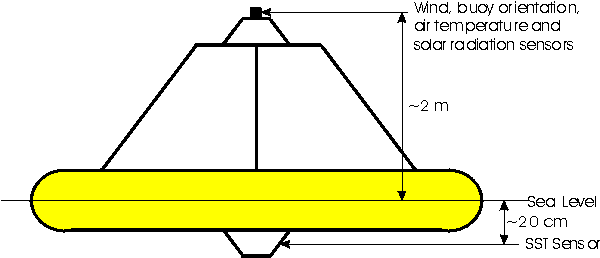
POL Meteorological Buoy
A large surface toroid buoy with a light tower and metal rail for instrument mounting, secured at the sea floor by a 500kg anchor chain.
Geometry
Instrumentation
Aanderaa Wind Speed Sensor (Model 2593)
The Wind Speed Sensor 2593 consists of a three-cup rotor on top of an ABS housing. The rotor bearing consists of two stainless steel ball bearings, protected by a surrounding skirt. The lower end of the skirt is furnished with a magnet. The magnet's rotation is sensed by a reed contact located inside the housing.
Manufacturer's specifications:
| THRESHOLD SPEED | 30 to 50 cm/s |
| ACCURACY | +/- 2 % |
| TEMPERATURE RANGE | -40 to +50 degC |
Aanderaa Instruments Wind Direction Sensor (Model 2053)
This sensor consists of a light wind vane which can turn on a vertical pivot, mounted on top of an ABS housing. The housing is furnished with a built-in compass (with electric read out) that is magnetically coupled to the vane. True wind speed measurements can be achieved by employing this instrument in conjunction with Aanderaa Instruments Buoy Orientation Sensor (Model 2084).
Manufacturer's specification:
| THRESHOLD SPEED | less than 30 cm/s |
| ACCURACY | better than +/- 5 degrees |
| TEMPERATURE RANGE | -40 to +50 deg C |
Aanderaa Instruments Solar Radiation Sensor (Model 2770)
This sensor employs a high sensitivity thermistor bridge which measures the temperature rise of a black surface under a glass dome.
Manufacturer's specification:
| WAVELENGTH | 0.3 to 2.5 micron |
| RESOLUTION | 4 W/m2 |
| ACCURACY | better than +/- 20 W/m2 |
| RANGE | 0 to 2000 W/m2 |
Aanderaa Instruments Temperature Sensor
This sensor is a platinum resistance thermometer designed for water and soil measurements.
Manufacturer's specification:
| MEASURING RANGE | -44 to +49 degC |
| ACCURACY | +/- 0.1 or +/- 0.25 degC (depending on model) |
Aanderaa Instruments Air Temperature Sensor (Model 2775)
This sensor consists of a platinum resistance thermometer fitted inside a radiation screen.
Manufacturer's specifications:
| MEASURING RANGE | -44 to +49 degC |
| ACCURACY | +/- 0.1 degC |
Meteorological Buoy Calibrations
Calibration Formulae
The following formulae were used to convert from datalogger readings to scientific units.
-
Wind Speed (m/s) = 0.074625 x (datalogger reading)
[source: Aanderaa Instruments] -
Wind Direction (deg) = 0.3515625 x (datalogger reading)
further corrected to True North by subtraction of 9 degrees
[source: Proudman Oceanographic Laboratory] -
Solar Radiation (W/m2) = (datalogger reading - 666) / 0.252
[source: BODC, derived from shipborne solarimeters nearby] -
Air Temperature (°C) = (datalogger reading - 717) / 6.94
[source: BODC, derived from land-based met station data] -
Sea Surface Temperature (°C) = (datalogger reading - 266) / 19.3
[source: BODC, derived from nearby CTD data]
Meteorological Buoy Data Processing
Data Originator's Processing
The following procedures are carried out before the data were supplied to BODC.
Data were downloaded from the instrument logger, and factory calibrations were applied to the wind speed and direction sensors. All channels were inspected visually, and large spikes exhibited by the sea temperature channel were removed and the resulting gaps filled by interpolation.
Shipboard measurements taken at the times of deployment and recovery were used to nominally calibrate the temperature sensors into scientific units.
BODC Data Processing and Quality Control
BODC screen both the series header qualifying information and the parameter values in the data cycles themselves.
Header information is inspected for:
- Irregularities such as suspect values.
- Inconsistencies between related information, for example:
- Times for mooring deployment and for start/end of data series.
- Length of record or number of data cycles, the cycle interval, the clock error and the period over which accrued.
- Parameters expected and the parameters actually present in the data cycles.
- Originator's comments on meter/mooring performance and data quality.
Documents are written by BODC highlighting irregularities which cannot be resolved.
Data cycles are inspected using time series plots of all parameters. Values suspected of being of non-meteorological origin may be tagged origin may be tagged with the BODC flag denoting suspect value.
As the sea surface and air temperature channels were only very crudely calibrated by the data originator, the datalogger readings were recomputed and the channels recalibrated to enhance the accuracy of the data.
The solar radiation channel was converted from datalogger readings to Watts per square metre by linear regression against calibrated shipboard solar radiation data collected in the vicinity of the rig.
Likewise, the sea surface temperature channel was converted to Centigrade by linear regression against CTD and calibrated thermosalinograph data.
As no shipboard measurements were available for the calibration of the air temperature sensor, the datalogger readings were compared with data from the Meteorological Office Monitoring station at Tiree for the period of deployment.
Project Information
LOIS Shelf Edge Study (LOIS - SES)
Introduction
SES was a component of the NERC Land Ocean Interaction Study (LOIS) Community Research Programme that made intensive measurements from the shelf break in the region known as the Hebridean Slope from March 1995 to September 1996.
Scientific Rationale
SES was devoted to the study of interactions between the shelf seas and the open ocean. The specific objectives of the project were:
-
To identify the time and space scales of ocean-shelf momentum transmission and to quantify the contributions to ocean-shelf water exchange by physical processes.
-
To estimate fluxes of water, heat and certain dissolved and suspended constituents across a section of the shelf edge with special emphasis on net carbon export from, and nutrient import to, the shelf.
-
To incorporate process understanding into models and test these models by comparison with observations and provide a basis for estimation of fluxes integrated over time and the length of the shelf.
Fieldwork
The SES fieldwork was focussed on a box enclosing two sections across the shelf break at 56.4-56.5 °N and 56.6-56.7 °N. Moored instrument arrays were maintained throughout the experiment at stations with water depths ranging from 140 m to 1500 m, although there were heavy losses due to the intensive fishing activity in the area. The moorings included meteorological buoys, current meters, transmissometers, fluorometers, nutrient analysers (but these never returned any usable data), thermistor chains, colour sensors and sediment traps.
The moorings were serviced by research cruises at approximately three-monthly intervals. In addition to the mooring work this cruises undertook intensive CTD, water bottle and benthic surveys with cruise durations of up to 6 weeks (3 legs of approximately 2 weeks each).
Moored instrument activities associated with SES comprised current measurements in the North Channel in 1993 and the Tiree Passage from 1995-1996. These provided boundary conditions for SES modelling activities.
Additional data were provided through cruises undertaken by the Defence Evaluation and Research Agency (DERA) in a co-operative programme known as SESAME.
Land Ocean Interaction Study (LOIS)
Introduction
The Land Ocean Interaction Study (LOIS) was a Community Research Project of the Natural Environment Research Council (NERC). The broad aim of LOIS was to gain an understanding of, and an ability to predict, the nature of environmental change in the coastal zone around the UK through an integrated study from the river catchments through to the shelf break.
LOIS was a collaborative, multidisciplinary study undertaken by scientists from NERC research laboratories and Higher Education institutions. The LOIS project was managed from NERC's Plymouth Marine Laboratory.
The project ran for six years from April 1992 until April 1998 with a further modelling and synthesis phase beginning in April 1998 and ending in April 2000.
Project Structure
LOIS consisted of the following components:
- River-Atmosphere-Coast Study (RACS)
- RACS(A) - Atmospheric sub-component
- RACS(C) - Coasts sub-component
- RACS(R) - Rivers sub-component
- BIOTA - Terrestrial salt marsh study
- Land Ocean Evolution Perspective Study (LOEPS)
- Shelf-Edge Study (SES)
- North Sea Modelling Study (NORMS)
- Data Management (DATA)
Marine Fieldwork
Marine field data were collected between September 1993 and September 1997 as part of RACS(C) and SES. The RACS data were collected throughout this period from the estuaries and coastal waters of the UK North Sea coast from Great Yarmouth to the Tweed. The SES data were collected between March 1995 and September 1996 from the Hebridean slope. Both the RACS and SES data sets incorporate a broad spectrum of measurements collected using moored instruments and research vessel surveys.
Data Activity or Cruise Information
No Data Activity or Cruise Information held for the Series
Fixed Station Information
Fixed Station Information
| Station Name | LOIS(SES) S140 |
| Category | Offshore location |
| Latitude | 56° 27.14' N |
| Longitude | 8° 58.27' W |
| Water depth below MSL | 145.0 m |
LOIS (SES) Mooring and CTD Site S140
Site S140 was a fixed station where moorings were deployed during the Land-Ocean Interaction Study (LOIS) Shelf Edge Study (SES). It was also one of fourteen CTD sites on repeat section S, across the Hebridean Slope, occupied by cruises between March 1995 and September 1996.
Instrument Deployment History
The following tables summarise the instruments deployed at this site for which data may be available.
1995
| Mar | Apr | May | Jun | Jul | Aug | Sep | Oct | Nov | Dec | |
|---|---|---|---|---|---|---|---|---|---|---|
| CM | a | a | b | b | c | c | d | |||
| Met | a | a | b | b | b | b | b | |||
| BPR | a | a | b | b | b | c | c | d | d | e |
| ADCP | a | a | a | b | b | c | c | d | ||
| TChn | a | a | a | b | c | d | d | |||
| Tr | a | a | a | b | c | d | e | e | ||
| Fl | a | a | a | b | c | d | e | e | ||
| NA | a | a | ||||||||
| WR | a | a | a | |||||||
| OCS | a | a | a | b |
1996
| Jan | Feb | Mar | Apr | May | Jun | Jul | Aug | |
|---|---|---|---|---|---|---|---|---|
| CM | d | d | e | e | f | f | f | g |
| Met | c | c | c | c | ||||
| BPR | e | e | f | f | g | g | g | h |
| ADCP | d | d | e | e | f | f | f | g |
| TChn | e | e | e | f | ||||
| Tr | f | f | g | g | g | h | ||
| Fl | f | f | g | g | g | h | ||
| NA | b | b | b | |||||
| OCS | c | c | c |
Each different letter in the tables above corresponds to an individual instrument record.
Glossary
- CM = Current meter (Aanderaa or S4)
- Met = Meteorology
- BPR = Bottom pressure recorder
- ADCP = Acoustic doppler current profiler
- TChn = Thermistor chain
- Tr = Transmissometer
- Fl = Fluorometer
- NA = Nutrient analyser
- WR = Waverider
- OCS = Ocean colour sensor
Notes
- Transmissometers may have been fitted to some of the current meters.
- Only periods for which useful data were returned are shown.
Related Fixed Station activities are detailed in Appendix 1
BODC Quality Control Flags
The following single character qualifying flags may be associated with one or more individual parameters with a data cycle:
| Flag | Description |
|---|---|
| Blank | Unqualified |
| < | Below detection limit |
| > | In excess of quoted value |
| A | Taxonomic flag for affinis (aff.) |
| B | Beginning of CTD Down/Up Cast |
| C | Taxonomic flag for confer (cf.) |
| D | Thermometric depth |
| E | End of CTD Down/Up Cast |
| G | Non-taxonomic biological characteristic uncertainty |
| H | Extrapolated value |
| I | Taxonomic flag for single species (sp.) |
| K | Improbable value - unknown quality control source |
| L | Improbable value - originator's quality control |
| M | Improbable value - BODC quality control |
| N | Null value |
| O | Improbable value - user quality control |
| P | Trace/calm |
| Q | Indeterminate |
| R | Replacement value |
| S | Estimated value |
| T | Interpolated value |
| U | Uncalibrated |
| W | Control value |
| X | Excessive difference |
SeaDataNet Quality Control Flags
The following single character qualifying flags may be associated with one or more individual parameters with a data cycle:
| Flag | Description |
|---|---|
| 0 | no quality control |
| 1 | good value |
| 2 | probably good value |
| 3 | probably bad value |
| 4 | bad value |
| 5 | changed value |
| 6 | value below detection |
| 7 | value in excess |
| 8 | interpolated value |
| 9 | missing value |
| A | value phenomenon uncertain |
| B | nominal value |
| Q | value below limit of quantification |
Appendix 1: LOIS(SES) S140
Related series for this Fixed Station are presented in the table below. Further information can be found by following the appropriate links.
If you are interested in these series, please be aware we offer a multiple file download service. Should your credentials be insufficient for automatic download, the service also offers a referral to our Enquiries Officer who may be able to negotiate access.
| Series Identifier | Data Category | Start date/time | Start position | Cruise |
|---|---|---|---|---|
| 427378 | Meteorology -meteorological data buoy | 1995-03-23 16:41:55 | 56.4523 N, 8.9712 W | Not applicable |
| 442639 | Offshore sea floor pressure series | 1995-03-27 22:45:30 | 56.4587 N, 8.9745 W | RRS Charles Darwin CD91B |
| 439171 | Currents -subsurface Eulerian | 1995-03-31 13:35:00 | 56.4678 N, 8.9612 W | RRS Charles Darwin CD91B |
| 439183 | Currents -subsurface Eulerian | 1995-03-31 13:35:00 | 56.4678 N, 8.9612 W | RRS Charles Darwin CD91B |
| 444204 | Currents -subsurface Eulerian | 1995-05-08 08:45:00 | 56.4608 N, 8.9652 W | RRS Charles Darwin CD93A |
| 442676 | Offshore sea floor pressure series | 1995-05-08 08:45:30 | 56.4608 N, 8.9652 W | RRS Charles Darwin CD93A |
| 426117 | Currents -subsurface Eulerian | 1995-05-09 09:32:30 | 56.4687 N, 8.961 W | RRS Charles Darwin CD93A |
| 442547 | Hydrography time series at depth | 1995-05-09 10:00:00 | 56.4687 N, 8.961 W | RRS Charles Darwin CD93A |
| 442559 | Hydrography time series at depth | 1995-05-09 10:00:00 | 56.4687 N, 8.961 W | RRS Charles Darwin CD93A |
| 439484 | Currents -subsurface Eulerian | 1995-05-09 15:45:00 | 56.4687 N, 8.961 W | RRS Charles Darwin CD93A |
| 496059 | Transmittance/attenuance, turbidity, or SPM conc. | 1995-05-15 09:56:00 | 56.4663 N, 8.9618 W | RRS Charles Darwin CD93A |
| 476046 | Fluorescence or pigments | 1995-05-15 11:02:57 | 56.4663 N, 8.9618 W | RRS Charles Darwin CD93A |
| 506050 | PAR radiance and irradiance | 1995-05-15 12:01:00 | 56.4663 N, 8.9618 W | RRS Charles Darwin CD93A |
| 496060 | Transmittance/attenuance, turbidity, or SPM conc. | 1995-07-24 17:15:00 | 56.466 N, 8.9518 W | RRS Challenger CH120 |
| 439496 | Hydrography time series at depth | 1995-07-24 17:30:00 | 56.466 N, 8.9518 W | RRS Challenger CH120 |
| 476163 | Fluorescence or pigments | 1995-07-24 20:09:18 | 56.466 N, 8.9518 W | RRS Challenger CH120 |
| 506062 | PAR radiance and irradiance | 1995-07-25 12:01:00 | 56.466 N, 8.9518 W | RRS Challenger CH120 |
| 436185 | Currents -subsurface Eulerian | 1995-08-11 19:17:30 | 56.4623 N, 8.9639 W | RRS Challenger CH121A |
| 439503 | Hydrography time series at depth | 1995-08-11 19:18:00 | 56.4623 N, 8.9639 W | RRS Challenger CH121A |
| 426129 | Currents -subsurface Eulerian | 1995-08-11 19:22:30 | 56.4623 N, 8.9639 W | RRS Challenger CH121A |
| 496127 | Transmittance/attenuance, turbidity, or SPM conc. | 1995-08-15 19:04:03 | 56.4665 N, 8.9617 W | RRS Challenger CH121A |
| 439668 | Hydrography time series at depth | 1995-08-15 19:26:00 | 56.4665 N, 8.9617 W | RRS Challenger CH121A |
| 476071 | Fluorescence or pigments | 1995-08-15 20:02:56 | 56.4665 N, 8.9617 W | RRS Challenger CH121A |
| 442688 | Offshore sea floor pressure series | 1995-08-17 12:40:30 | 56.4605 N, 8.9672 W | RRS Challenger CH121A |
| 444216 | Currents -subsurface Eulerian | 1995-08-17 12:41:00 | 56.4605 N, 8.9672 W | RRS Challenger CH121A |
| 439379 | Currents -subsurface Eulerian | 1995-09-02 08:44:00 | 56.4618 N, 8.9642 W | RRS Challenger CH121C |
| 439515 | Hydrography time series at depth | 1995-09-02 09:00:00 | 56.4618 N, 8.9642 W | RRS Challenger CH121C |
| 436197 | Currents -subsurface Eulerian | 1995-09-02 09:15:00 | 56.4618 N, 8.9642 W | RRS Challenger CH121C |
| 496139 | Transmittance/attenuance, turbidity, or SPM conc. | 1995-09-04 16:12:00 | 56.4663 N, 8.9588 W | RRS Challenger CH121C |
| 476083 | Fluorescence or pigments | 1995-09-04 17:02:56 | 56.4663 N, 8.9588 W | RRS Challenger CH121C |
| 442640 | Offshore sea floor pressure series | 1995-09-04 18:30:21 | 56.4637 N, 8.9665 W | RRS Challenger CH121C |
| 444197 | Currents -subsurface Eulerian | 1995-09-04 18:34:59 | 56.4637 N, 8.9665 W | RRS Challenger CH121C |
| 507815 | Waves (unspecified) | 1995-09-05 18:00:00 | 56.4578 N, 8.9705 W | RRS Challenger CH121C |
| 436148 | Currents -subsurface Eulerian | 1995-11-19 17:15:00 | 56.4487 N, 8.9794 W | RRS Challenger CH123A |
| 439367 | Currents -subsurface Eulerian | 1995-11-19 17:15:00 | 56.4487 N, 8.9627 W | RRS Challenger CH123A |
| 442664 | Offshore sea floor pressure series | 1995-11-19 17:30:25 | 56.4485 N, 8.98383 W | RRS Challenger CH123A |
| 444241 | Currents -subsurface Eulerian | 1995-11-19 17:34:59 | 56.4485 N, 8.9838 W | RRS Challenger CH123A |
| 496152 | Transmittance/attenuance, turbidity, or SPM conc. | 1995-11-27 15:54:59 | 56.4453 N, 8.9758 W | RRS Challenger CH123A |
| 476231 | Fluorescence or pigments | 1995-11-27 20:01:48 | 56.4453 N, 8.9758 W | RRS Challenger CH123A |
| 436228 | Currents -subsurface Eulerian | 1996-02-01 09:45:00 | 56.4602 N, 8.9645 W | RRS Challenger CH125A |
| 439380 | Currents -subsurface Eulerian | 1996-02-01 09:45:00 | 56.4602 N, 8.9645 W | RRS Challenger CH125A |
| 442719 | Offshore sea floor pressure series | 1996-02-01 11:50:21 | 56.4585 N, 8.9632 W | RRS Challenger CH125A |
| 489769 | Currents -subsurface Eulerian | 1996-02-01 11:55:00 | 56.4585 N, 8.9632 W | RRS Challenger CH125A |
| 491909 | Transmittance/attenuance, turbidity, or SPM conc. | 1996-02-01 13:17:00 | 56.4588 N, 8.967 W | RRS Challenger CH125A |
| 476138 | Fluorescence or pigments | 1996-02-01 16:02:53 | 56.4588 N, 8.967 W | RRS Challenger CH125A |
| 427391 | Meteorology -meteorological data buoy | 1996-04-15 13:05:52 | 56.4537 N, 8.9632 W | Not applicable |
| 496164 | Transmittance/attenuance, turbidity, or SPM conc. | 1996-04-17 08:05:00 | 56.4672 N, 8.9627 W | RRS Challenger CH126A |
| 477246 | Hydrography time series at depth | 1996-04-17 08:10:00 | 56.4672 N, 8.9627 W | RRS Challenger CH126A |
| 506086 | PAR radiance and irradiance | 1996-04-17 12:11:00 | 56.4672 N, 8.9627 W | RRS Challenger CH126A |
| 442479 | Hydrography time series at depth | 1996-04-17 12:30:00 | 56.4672 N, 8.9627 W | RRS Challenger CH126A |
| 476151 | Fluorescence or pigments | 1996-04-17 15:02:57 | 56.4633 N, 8.9585 W | RRS Challenger CH126A |
| 438874 | Currents -subsurface Eulerian | 1996-04-17 15:15:00 | 56.4633 N, 8.9585 W | RRS Challenger CH126A |
| 439411 | Currents -subsurface Eulerian | 1996-04-17 15:30:00 | 56.4633 N, 8.9585 W | RRS Challenger CH126A |
| 442584 | Hydrography time series at depth | 1996-04-17 15:30:00 | 56.462 N, 8.9615 W | RRS Challenger CH126A |
| 442596 | Hydrography time series at depth | 1996-04-17 15:30:00 | 56.462 N, 8.9615 W | RRS Challenger CH126A |
| 438929 | Currents -subsurface Eulerian | 1996-04-17 19:15:00 | 56.4633 N, 8.9585 W | RRS Challenger CH126A |
| 477209 | Currents -subsurface Eulerian | 1996-04-24 08:34:59 | 56.4588 N, 8.9608 W | RRS Challenger CH126A |
| 477210 | Currents -subsurface Eulerian | 1996-07-13 12:29:00 | 56.4595 N, 8.9613 W | RRS Challenger CH128A |
| 442387 | Hydrography time series at depth | 1996-07-13 15:44:00 | 56.4565 N, 8.9658 W | RRS Challenger CH128A |
| 477399 | Hydrography time series at depth | 1996-07-13 15:44:00 | 56.4565 N, 8.9658 W | RRS Challenger CH128A |
| 444437 | Currents -subsurface Eulerian | 1996-07-13 15:45:00 | 56.4565 N, 8.9658 W | RRS Challenger CH128A |
| 439029 | Currents -subsurface Eulerian | 1996-07-13 16:05:30 | 56.4565 N, 8.9658 W | RRS Challenger CH128A |
