Metadata Report for BODC Series Reference Number 507815
Metadata Summary
Problem Reports
Data Access Policy
Narrative Documents
Project Information
Data Activity or Cruise Information
Fixed Station Information
BODC Quality Flags
SeaDataNet Quality Flags
Metadata Summary
Data Description |
|||||||||||||||||||||||||
|
|||||||||||||||||||||||||
Data Identifiers |
|||||||||||||||||||||||||
|
|||||||||||||||||||||||||
Time Co-ordinates(UT) |
|||||||||||||||||||||||||
|
|||||||||||||||||||||||||
Spatial Co-ordinates | |||||||||||||||||||||||||
|
|||||||||||||||||||||||||
Parameters |
|||||||||||||||||||||||||
|
|||||||||||||||||||||||||
|
|||||||||||||||||||||||||
Problem Reports
The mooring broke free during November 1995.
All data after 07 November 1995 06:00 has been ignored.
Data Access Policy
Open Data
These data have no specific confidentiality restrictions for users. However, users must acknowledge data sources as it is not ethical to publish data without proper attribution. Any publication or other output resulting from usage of the data should include an acknowledgment.
If the Information Provider does not provide a specific attribution statement, or if you are using Information from several Information Providers and multiple attributions are not practical in your product or application, you may consider using the following:
"Contains public sector information licensed under the Open Government Licence v1.0."
Narrative Documents
No Narrative Document information held in the BODC database
Project Information
Land Ocean Interaction Study (LOIS)
Introduction
The Land Ocean Interaction Study (LOIS) was a Community Research Project of the Natural Environment Research Council (NERC). The broad aim of LOIS was to gain an understanding of, and an ability to predict, the nature of environmental change in the coastal zone around the UK through an integrated study from the river catchments through to the shelf break.
LOIS was a collaborative, multidisciplinary study undertaken by scientists from NERC research laboratories and Higher Education institutions. The LOIS project was managed from NERC's Plymouth Marine Laboratory.
The project ran for six years from April 1992 until April 1998 with a further modelling and synthesis phase beginning in April 1998 and ending in April 2000.
Project Structure
LOIS consisted of the following components:
- River-Atmosphere-Coast Study (RACS)
- RACS(A) - Atmospheric sub-component
- RACS(C) - Coasts sub-component
- RACS(R) - Rivers sub-component
- BIOTA - Terrestrial salt marsh study
- Land Ocean Evolution Perspective Study (LOEPS)
- Shelf-Edge Study (SES)
- North Sea Modelling Study (NORMS)
- Data Management (DATA)
Marine Fieldwork
Marine field data were collected between September 1993 and September 1997 as part of RACS(C) and SES. The RACS data were collected throughout this period from the estuaries and coastal waters of the UK North Sea coast from Great Yarmouth to the Tweed. The SES data were collected between March 1995 and September 1996 from the Hebridean slope. Both the RACS and SES data sets incorporate a broad spectrum of measurements collected using moored instruments and research vessel surveys.
LOIS Shelf Edge Study (LOIS - SES)
Introduction
SES was a component of the NERC Land Ocean Interaction Study (LOIS) Community Research Programme that made intensive measurements from the shelf break in the region known as the Hebridean Slope from March 1995 to September 1996.
Scientific Rationale
SES was devoted to the study of interactions between the shelf seas and the open ocean. The specific objectives of the project were:
-
To identify the time and space scales of ocean-shelf momentum transmission and to quantify the contributions to ocean-shelf water exchange by physical processes.
-
To estimate fluxes of water, heat and certain dissolved and suspended constituents across a section of the shelf edge with special emphasis on net carbon export from, and nutrient import to, the shelf.
-
To incorporate process understanding into models and test these models by comparison with observations and provide a basis for estimation of fluxes integrated over time and the length of the shelf.
Fieldwork
The SES fieldwork was focussed on a box enclosing two sections across the shelf break at 56.4-56.5 °N and 56.6-56.7 °N. Moored instrument arrays were maintained throughout the experiment at stations with water depths ranging from 140 m to 1500 m, although there were heavy losses due to the intensive fishing activity in the area. The moorings included meteorological buoys, current meters, transmissometers, fluorometers, nutrient analysers (but these never returned any usable data), thermistor chains, colour sensors and sediment traps.
The moorings were serviced by research cruises at approximately three-monthly intervals. In addition to the mooring work this cruises undertook intensive CTD, water bottle and benthic surveys with cruise durations of up to 6 weeks (3 legs of approximately 2 weeks each).
Moored instrument activities associated with SES comprised current measurements in the North Channel in 1993 and the Tiree Passage from 1995-1996. These provided boundary conditions for SES modelling activities.
Additional data were provided through cruises undertaken by the Defence Evaluation and Research Agency (DERA) in a co-operative programme known as SESAME.
Data Activity or Cruise Information
Data Activity
| Start Date (yyyy-mm-dd) | 1995-09-05 |
| End Date (yyyy-mm-dd) | 1996-01-31 |
| Organization Undertaking Activity | Proudman Oceanographic Laboratory (now National Oceanography Centre, Liverpool) |
| Country of Organization | United Kingdom |
| Originator's Data Activity Identifier | POLRIG#744 |
| Platform Category | moored surface buoy |
Proudman Oceanographic Laboratory Moored Instrument Rig#744
The POL waverider rig#744 was deployed as part of LOIS Shelf Edge Study at site S140.
| Rig position | 56° 27.47' N 08° 58.23' W |
|---|---|
| Deployed | 05 September 1995 from RRS Challenger (cruise CH121C) |
| Recovered | 31 January 1996 after breaking free of mooring on 7 November 1995. |
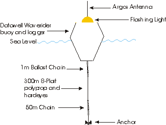
Instrumentation
| Datawell Waverider | The spherical Datawell Waverider buoy has a diameter of 0.9m and a weight of 212Kg. The Waverider measured only wave height and wave period by recording the vertical acceleration of the buoy. The discrepancy between Waverider movement and the vertical movement of the sea surface is small. The Waverider's accuracy decreases significantly below wave lengths of 2.5m (wave period 1.25 seconds). |
|---|---|
| Other Instrumentation | Argos Transmitter Serial no. 3704 Synergetics 14A Serial no. 2390A861 |
Cruise
| Cruise Name | CH121C |
| Departure Date | 1995-09-01 |
| Arrival Date | 1995-09-10 |
| Principal Scientist(s) | John H Simpson (University of Wales, Bangor School of Ocean Sciences) |
| Ship | RRS Challenger |
Complete Cruise Metadata Report is available here
Fixed Station Information
Fixed Station Information
| Station Name | LOIS(SES) S140 |
| Category | Offshore location |
| Latitude | 56° 27.14' N |
| Longitude | 8° 58.27' W |
| Water depth below MSL | 145.0 m |
LOIS (SES) Mooring and CTD Site S140
Site S140 was a fixed station where moorings were deployed during the Land-Ocean Interaction Study (LOIS) Shelf Edge Study (SES). It was also one of fourteen CTD sites on repeat section S, across the Hebridean Slope, occupied by cruises between March 1995 and September 1996.
Instrument Deployment History
The following tables summarise the instruments deployed at this site for which data may be available.
1995
| Mar | Apr | May | Jun | Jul | Aug | Sep | Oct | Nov | Dec | |
|---|---|---|---|---|---|---|---|---|---|---|
| CM | a | a | b | b | c | c | d | |||
| Met | a | a | b | b | b | b | b | |||
| BPR | a | a | b | b | b | c | c | d | d | e |
| ADCP | a | a | a | b | b | c | c | d | ||
| TChn | a | a | a | b | c | d | d | |||
| Tr | a | a | a | b | c | d | e | e | ||
| Fl | a | a | a | b | c | d | e | e | ||
| NA | a | a | ||||||||
| WR | a | a | a | |||||||
| OCS | a | a | a | b |
1996
| Jan | Feb | Mar | Apr | May | Jun | Jul | Aug | |
|---|---|---|---|---|---|---|---|---|
| CM | d | d | e | e | f | f | f | g |
| Met | c | c | c | c | ||||
| BPR | e | e | f | f | g | g | g | h |
| ADCP | d | d | e | e | f | f | f | g |
| TChn | e | e | e | f | ||||
| Tr | f | f | g | g | g | h | ||
| Fl | f | f | g | g | g | h | ||
| NA | b | b | b | |||||
| OCS | c | c | c |
Each different letter in the tables above corresponds to an individual instrument record.
Glossary
- CM = Current meter (Aanderaa or S4)
- Met = Meteorology
- BPR = Bottom pressure recorder
- ADCP = Acoustic doppler current profiler
- TChn = Thermistor chain
- Tr = Transmissometer
- Fl = Fluorometer
- NA = Nutrient analyser
- WR = Waverider
- OCS = Ocean colour sensor
Notes
- Transmissometers may have been fitted to some of the current meters.
- Only periods for which useful data were returned are shown.
Related Fixed Station activities are detailed in Appendix 1
BODC Quality Control Flags
The following single character qualifying flags may be associated with one or more individual parameters with a data cycle:
| Flag | Description |
|---|---|
| Blank | Unqualified |
| < | Below detection limit |
| > | In excess of quoted value |
| A | Taxonomic flag for affinis (aff.) |
| B | Beginning of CTD Down/Up Cast |
| C | Taxonomic flag for confer (cf.) |
| D | Thermometric depth |
| E | End of CTD Down/Up Cast |
| G | Non-taxonomic biological characteristic uncertainty |
| H | Extrapolated value |
| I | Taxonomic flag for single species (sp.) |
| K | Improbable value - unknown quality control source |
| L | Improbable value - originator's quality control |
| M | Improbable value - BODC quality control |
| N | Null value |
| O | Improbable value - user quality control |
| P | Trace/calm |
| Q | Indeterminate |
| R | Replacement value |
| S | Estimated value |
| T | Interpolated value |
| U | Uncalibrated |
| W | Control value |
| X | Excessive difference |
SeaDataNet Quality Control Flags
The following single character qualifying flags may be associated with one or more individual parameters with a data cycle:
| Flag | Description |
|---|---|
| 0 | no quality control |
| 1 | good value |
| 2 | probably good value |
| 3 | probably bad value |
| 4 | bad value |
| 5 | changed value |
| 6 | value below detection |
| 7 | value in excess |
| 8 | interpolated value |
| 9 | missing value |
| A | value phenomenon uncertain |
| B | nominal value |
| Q | value below limit of quantification |
Appendix 1: LOIS(SES) S140
Related series for this Fixed Station are presented in the table below. Further information can be found by following the appropriate links.
If you are interested in these series, please be aware we offer a multiple file download service. Should your credentials be insufficient for automatic download, the service also offers a referral to our Enquiries Officer who may be able to negotiate access.
| Series Identifier | Data Category | Start date/time | Start position | Cruise |
|---|---|---|---|---|
| 427378 | Meteorology -meteorological data buoy | 1995-03-23 16:41:55 | 56.4523 N, 8.9712 W | Not applicable |
| 442639 | Offshore sea floor pressure series | 1995-03-27 22:45:30 | 56.4587 N, 8.9745 W | RRS Charles Darwin CD91B |
| 439171 | Currents -subsurface Eulerian | 1995-03-31 13:35:00 | 56.4678 N, 8.9612 W | RRS Charles Darwin CD91B |
| 439183 | Currents -subsurface Eulerian | 1995-03-31 13:35:00 | 56.4678 N, 8.9612 W | RRS Charles Darwin CD91B |
| 444204 | Currents -subsurface Eulerian | 1995-05-08 08:45:00 | 56.4608 N, 8.9652 W | RRS Charles Darwin CD93A |
| 442676 | Offshore sea floor pressure series | 1995-05-08 08:45:30 | 56.4608 N, 8.9652 W | RRS Charles Darwin CD93A |
| 426117 | Currents -subsurface Eulerian | 1995-05-09 09:32:30 | 56.4687 N, 8.961 W | RRS Charles Darwin CD93A |
| 442547 | Hydrography time series at depth | 1995-05-09 10:00:00 | 56.4687 N, 8.961 W | RRS Charles Darwin CD93A |
| 442559 | Hydrography time series at depth | 1995-05-09 10:00:00 | 56.4687 N, 8.961 W | RRS Charles Darwin CD93A |
| 439484 | Currents -subsurface Eulerian | 1995-05-09 15:45:00 | 56.4687 N, 8.961 W | RRS Charles Darwin CD93A |
| 496059 | Transmittance/attenuance, turbidity, or SPM conc. | 1995-05-15 09:56:00 | 56.4663 N, 8.9618 W | RRS Charles Darwin CD93A |
| 476046 | Fluorescence or pigments | 1995-05-15 11:02:57 | 56.4663 N, 8.9618 W | RRS Charles Darwin CD93A |
| 506050 | PAR radiance and irradiance | 1995-05-15 12:01:00 | 56.4663 N, 8.9618 W | RRS Charles Darwin CD93A |
| 496060 | Transmittance/attenuance, turbidity, or SPM conc. | 1995-07-24 17:15:00 | 56.466 N, 8.9518 W | RRS Challenger CH120 |
| 439496 | Hydrography time series at depth | 1995-07-24 17:30:00 | 56.466 N, 8.9518 W | RRS Challenger CH120 |
| 476163 | Fluorescence or pigments | 1995-07-24 20:09:18 | 56.466 N, 8.9518 W | RRS Challenger CH120 |
| 506062 | PAR radiance and irradiance | 1995-07-25 12:01:00 | 56.466 N, 8.9518 W | RRS Challenger CH120 |
| 436185 | Currents -subsurface Eulerian | 1995-08-11 19:17:30 | 56.4623 N, 8.9639 W | RRS Challenger CH121A |
| 439503 | Hydrography time series at depth | 1995-08-11 19:18:00 | 56.4623 N, 8.9639 W | RRS Challenger CH121A |
| 426129 | Currents -subsurface Eulerian | 1995-08-11 19:22:30 | 56.4623 N, 8.9639 W | RRS Challenger CH121A |
| 496127 | Transmittance/attenuance, turbidity, or SPM conc. | 1995-08-15 19:04:03 | 56.4665 N, 8.9617 W | RRS Challenger CH121A |
| 439668 | Hydrography time series at depth | 1995-08-15 19:26:00 | 56.4665 N, 8.9617 W | RRS Challenger CH121A |
| 476071 | Fluorescence or pigments | 1995-08-15 20:02:56 | 56.4665 N, 8.9617 W | RRS Challenger CH121A |
| 427366 | Meteorology -meteorological data buoy | 1995-08-17 11:30:53 | 56.4552 N, 8.974 W | Not applicable |
| 442688 | Offshore sea floor pressure series | 1995-08-17 12:40:30 | 56.4605 N, 8.9672 W | RRS Challenger CH121A |
| 444216 | Currents -subsurface Eulerian | 1995-08-17 12:41:00 | 56.4605 N, 8.9672 W | RRS Challenger CH121A |
| 439379 | Currents -subsurface Eulerian | 1995-09-02 08:44:00 | 56.4618 N, 8.9642 W | RRS Challenger CH121C |
| 439515 | Hydrography time series at depth | 1995-09-02 09:00:00 | 56.4618 N, 8.9642 W | RRS Challenger CH121C |
| 436197 | Currents -subsurface Eulerian | 1995-09-02 09:15:00 | 56.4618 N, 8.9642 W | RRS Challenger CH121C |
| 496139 | Transmittance/attenuance, turbidity, or SPM conc. | 1995-09-04 16:12:00 | 56.4663 N, 8.9588 W | RRS Challenger CH121C |
| 476083 | Fluorescence or pigments | 1995-09-04 17:02:56 | 56.4663 N, 8.9588 W | RRS Challenger CH121C |
| 442640 | Offshore sea floor pressure series | 1995-09-04 18:30:21 | 56.4637 N, 8.9665 W | RRS Challenger CH121C |
| 444197 | Currents -subsurface Eulerian | 1995-09-04 18:34:59 | 56.4637 N, 8.9665 W | RRS Challenger CH121C |
| 436148 | Currents -subsurface Eulerian | 1995-11-19 17:15:00 | 56.4487 N, 8.9794 W | RRS Challenger CH123A |
| 439367 | Currents -subsurface Eulerian | 1995-11-19 17:15:00 | 56.4487 N, 8.9627 W | RRS Challenger CH123A |
| 442664 | Offshore sea floor pressure series | 1995-11-19 17:30:25 | 56.4485 N, 8.98383 W | RRS Challenger CH123A |
| 444241 | Currents -subsurface Eulerian | 1995-11-19 17:34:59 | 56.4485 N, 8.9838 W | RRS Challenger CH123A |
| 496152 | Transmittance/attenuance, turbidity, or SPM conc. | 1995-11-27 15:54:59 | 56.4453 N, 8.9758 W | RRS Challenger CH123A |
| 476231 | Fluorescence or pigments | 1995-11-27 20:01:48 | 56.4453 N, 8.9758 W | RRS Challenger CH123A |
| 436228 | Currents -subsurface Eulerian | 1996-02-01 09:45:00 | 56.4602 N, 8.9645 W | RRS Challenger CH125A |
| 439380 | Currents -subsurface Eulerian | 1996-02-01 09:45:00 | 56.4602 N, 8.9645 W | RRS Challenger CH125A |
| 442719 | Offshore sea floor pressure series | 1996-02-01 11:50:21 | 56.4585 N, 8.9632 W | RRS Challenger CH125A |
| 489769 | Currents -subsurface Eulerian | 1996-02-01 11:55:00 | 56.4585 N, 8.9632 W | RRS Challenger CH125A |
| 491909 | Transmittance/attenuance, turbidity, or SPM conc. | 1996-02-01 13:17:00 | 56.4588 N, 8.967 W | RRS Challenger CH125A |
| 476138 | Fluorescence or pigments | 1996-02-01 16:02:53 | 56.4588 N, 8.967 W | RRS Challenger CH125A |
| 427391 | Meteorology -meteorological data buoy | 1996-04-15 13:05:52 | 56.4537 N, 8.9632 W | Not applicable |
| 496164 | Transmittance/attenuance, turbidity, or SPM conc. | 1996-04-17 08:05:00 | 56.4672 N, 8.9627 W | RRS Challenger CH126A |
| 477246 | Hydrography time series at depth | 1996-04-17 08:10:00 | 56.4672 N, 8.9627 W | RRS Challenger CH126A |
| 506086 | PAR radiance and irradiance | 1996-04-17 12:11:00 | 56.4672 N, 8.9627 W | RRS Challenger CH126A |
| 442479 | Hydrography time series at depth | 1996-04-17 12:30:00 | 56.4672 N, 8.9627 W | RRS Challenger CH126A |
| 476151 | Fluorescence or pigments | 1996-04-17 15:02:57 | 56.4633 N, 8.9585 W | RRS Challenger CH126A |
| 438874 | Currents -subsurface Eulerian | 1996-04-17 15:15:00 | 56.4633 N, 8.9585 W | RRS Challenger CH126A |
| 439411 | Currents -subsurface Eulerian | 1996-04-17 15:30:00 | 56.4633 N, 8.9585 W | RRS Challenger CH126A |
| 442584 | Hydrography time series at depth | 1996-04-17 15:30:00 | 56.462 N, 8.9615 W | RRS Challenger CH126A |
| 442596 | Hydrography time series at depth | 1996-04-17 15:30:00 | 56.462 N, 8.9615 W | RRS Challenger CH126A |
| 438929 | Currents -subsurface Eulerian | 1996-04-17 19:15:00 | 56.4633 N, 8.9585 W | RRS Challenger CH126A |
| 477209 | Currents -subsurface Eulerian | 1996-04-24 08:34:59 | 56.4588 N, 8.9608 W | RRS Challenger CH126A |
| 477210 | Currents -subsurface Eulerian | 1996-07-13 12:29:00 | 56.4595 N, 8.9613 W | RRS Challenger CH128A |
| 442387 | Hydrography time series at depth | 1996-07-13 15:44:00 | 56.4565 N, 8.9658 W | RRS Challenger CH128A |
| 477399 | Hydrography time series at depth | 1996-07-13 15:44:00 | 56.4565 N, 8.9658 W | RRS Challenger CH128A |
| 444437 | Currents -subsurface Eulerian | 1996-07-13 15:45:00 | 56.4565 N, 8.9658 W | RRS Challenger CH128A |
| 439029 | Currents -subsurface Eulerian | 1996-07-13 16:05:30 | 56.4565 N, 8.9658 W | RRS Challenger CH128A |
