Metadata Report for BODC Series Reference Number 1892491
Metadata Summary
Problem Reports
Data Access Policy
Narrative Documents
Project Information
Data Activity or Cruise Information
Fixed Station Information
BODC Quality Flags
SeaDataNet Quality Flags
Metadata Summary
Data Description |
|||||||||||||||||||||||||
|
|||||||||||||||||||||||||
Data Identifiers |
|||||||||||||||||||||||||
|
|||||||||||||||||||||||||
Time Co-ordinates(UT) |
|||||||||||||||||||||||||
|
|||||||||||||||||||||||||
Spatial Co-ordinates | |||||||||||||||||||||||||
|
|||||||||||||||||||||||||
Parameters |
|||||||||||||||||||||||||
|
|||||||||||||||||||||||||
|
|||||||||||||||||||||||||
Problem Reports
No Problem Report Found in the Database
Data Access Policy
Open Data
These data have no specific confidentiality restrictions for users. However, users must acknowledge data sources as it is not ethical to publish data without proper attribution. Any publication or other output resulting from usage of the data should include an acknowledgment.
If the Information Provider does not provide a specific attribution statement, or if you are using Information from several Information Providers and multiple attributions are not practical in your product or application, you may consider using the following:
"Contains public sector information licensed under the Open Government Licence v1.0."
Narrative Documents
Star-Oddi Starmon mini Temperature Recorder
Description
The Star-Oddi Starmon mini is a compact microprocessor-controlled temperature recorder with electronics and probe housed in a strong waterproof cylinder made of either plastic or titanium.
Specifications
| Memory | 350000 measurements, although memory size can optionally be increased to 524000 or 699000 measurements. Temperature readings are stored in non-volatile Electrically Erasable Programmable Read Only Memory (EEPROM). |
|---|---|
| Data Retention | 20 years. |
| Temperature Range | -2 °C to +40 °C with outside ranges available at request. The average resolution is 0.013 °C, and the measuring accuracy is +/-0.05 °C. |
| Maximum Depth | Plastic version: 400 m (40 bar), titanium version: 11000 m (1100 bar) |
| Communication Link | Downloaded via PC interface box. Connects to a computer via a RS-232C standard serial interface. |
| Battery | A 3.6 V lithium battery with a life of 5 years for a sampling interval of 10 minutes or greater. |
For more information please see the manufacturers specification sheet.
Shelf Sea Biogeochemistry (SSB) Star-Oddi DST CTD, Star-Oddi Starmon mini temperature recorder and RBR Solo T Temperature logger data from temperature chain mooring BODC Processing
Data from three instruments arrived at BODC in Matlab files. The instruments were the Star-Oddi DST CTD, Star-Oddi Starmon mini temperature recorder and RBR Solo T Temperature logger. The following table shows how the variables within the files were mapped to appropriate BODC parameter codes:
| Originator's Variable | Units | BODC Parameter Code | Units | Comment |
|---|---|---|---|---|
| temp | °C | TEMPPR01 | °C | - |
| depth | m | DPSAZZ01 | m | Depths were estimated from neighbouring instruments with pressure sensors by originator |
The reformatted data were visualised using the in-house visualisation software. Suspect data were marked by adding an appropriate quality control flag. Missing data are set to an appropriate value and the corresponding flag added. Data in files from the first deployment of the mooring were removed before 26/03/2014 00:00:00, the instruments had been set to begin recording on 19/03/2014 but were not deployed until 26/03/2014 16:51 therefore, data before this time was collected while the instruments were on deck. Data prior to deployment and post recovery of the fifth deployment have also been removed due to the instruments being left to record data while on deck for significant time periods.
Shelf Sea Biogeochemistry (SSB) mooring Originator's processing
Sampling and acquisition
The following information has been taken from the method statement (see Wihsgott) provided to BODC by the originator.
A long term temperature and salinity chain was deployed in the Central Celtic Sea (CCS) as part of the Shelf Sea Biogeochemistry programme. Five consecutive deployments covered a period of 17 months, from March 2014 to July 2015. The chain was deployed with a vertical resolution of 2.5 m in the main pycnocline region and 5 to 20 m vertical resolution in the surface and bottom layers. Sampling interval was set to 5 minutes for all instruments.
An alongside bedframe mooring included a SBE16plus instrument that was processed with the instruments from the temperature and salinity chain. The moorings were deployed less than a kilometre apart.
Pressure and conductivity were only recorded by the SBE instruments (SBE16plus, SBE37). For these instruments depth, salinity and potential density (for calibration purposes only) were derived using the Gibbs-SeaWater (GSW) Oceanographic Toolbox (McDougall and Barker, 2011).
Calibration procedures
The moored instruments were calibrated against pre- and post-deployment CTD casts. Each instrument accuracy was also taken into consideration when applying the correction. Small scale instances of vertical instability were not removed by the originator.
Time drift was identified in some instruments however a correction was not applied to the data as it was considered negligible when compared with the sampling interval and deployment period.
References
McDougall, T. J. and Barker, P. M. (2011) Getting started with TEOS-10 and the Gibbs Sea- water (GSW) Oceanographic Toolbox,. SCOR/IAPSO WG127.
Wihsgott, J. QC of long term TS-chain mooring at CCS, 13pp.
Project Information
Shelf Sea Biogeochemistry (SSB) Programme
Shelf Sea Biogeochemistry (SSB) is a £10.5 million, six-year (2011-2017) research programme, jointly funded by the Natural Environment Research Council (NERC) and the Department for Environment, Food and Rural Affairs (DEFRA). The aim of the research is to reduce the uncertainty in our understanding of nutrient and carbon cycling within the shelf seas, and of their role in global biogeochemical cycles. SSB will also provide effective policy advice and make a significant contribution to the Living with Environmental Change programme.
Background
The Shelf Sea Biogeochemistry research programme directly relates to the delivery of the NERC Earth system science theme and aims to provide evidence that supports a number of marine policy areas and statutory requirements, such as the Marine Strategy Framework Directive and Marine and Climate Acts.
The shelf seas are highly productive compared to the open ocean, a productivity that underpins more than 90 per cent of global fisheries. Their importance to society extends beyond food production to include issues of biodiversity, carbon cycling and storage, waste disposal, nutrient cycling, recreation and renewable energy resources.
The shelf seas have been estimated to be the most valuable biome on Earth, but they are under considerable stress, as a result of anthropogenic nutrient loading, overfishing, habitat disturbance, climate change and other impacts.
However, even within the relatively well-studied European shelf seas, fundamental biogeochemical processes are poorly understood. For example: the role of shelf seas in carbon storage; in the global cycles of key nutrients (nitrogen, phosphorus, silicon and iron); and in determining primary and secondary production, and thereby underpinning the future delivery of many other ecosystem services.
Improved knowledge of such factors is not only required by marine policymakers; it also has the potential to increase the quality and cost-effectiveness of management decisions at the local, national and international levels under conditions of climate change.
The Shelf Sea Biogeochemistry research programme will take a holistic approach to the cycling of nutrients and carbon and the controls on primary and secondary production in UK and European shelf seas, to increase understanding of these processes and their role in wider biogeochemical cycles. It will thereby significantly improve predictive marine biogeochemical and ecosystem models over a range of scales.
The scope of the programme includes exchanges with the open ocean (transport on and off the shelf to a depth of around 500m), together with cycling, storage and release processes on the shelf slope, and air-sea exchange of greenhouse gases (carbon dioxide and nitrous oxide).
Further details are available on the SSB website.
Participants
15 different organisations are directly involved in research for SSB. These institutions are
- Centre for Environment, Fisheries and Aquaculture Science (Cefas)
- Meteorological Office
- National Oceanography Centre (NOC)
- Plymouth Marine Laboratory (PML)
- Scottish Association for Marine Science (SAMS) / Scottish Marine Institute (SMI)
- University of Aberdeen
- University of Bangor
- University of East Anglia (UEA)
- University of Edinburgh
- University of Essex
- University of Liverpool
- University of Oxford
- Plymouth University
- University of Portsmouth
- University of Southampton
In addition, there are third party institutions carrying out sampling work for SSB, but who are not involved in the programme itself. These are:
- The Agri-Food and Biosciences Institute (AFBI)
- Irish Marine Institute (MI)
- Marine Science Scotland (MSS)
Research details
Overall, five Work Packages have been funded by the SSB programme. These are described in brief below:
-
Work Package 1: Carbon and Nutrient Dynamics and Fluxes over Shelf Systems (CaNDyFloSS).
This work package aims to perform a comprehensive study of the cycling of nutrients and carbon throughout the water column over the whole north-west European shelf. This will allow the fluxes of nutrients and carbon between the shelf and the deep ocean and atmosphere to be quantified, establishing the role of the north-west European continental shelf in the global carbon cycle. -
Work Package 2: Biogeochemistry, macronutrient and carbon cycling in the benthic layer.
This work package aims are to map the sensitivity and status of seabed habitats, based on physical conditions, ecological community structure and the size and dynamics of the nitrogen and carbon pools found there. This information will be used, in conjunction with some laboratory-based work, to generate an understanding of the potential impacts on the benthic community as a result of changing environmental conditions, such as rising CO2 levels. -
Work Package 3: The supply of iron from shelf sediments to the ocean.
The research for this work package addresses the question of how currents, tides, weather and marine chemistry allow new iron to be transported away from the shallow shelf waters around the United Kingdom (UK), to the nearby open ocean. This will ultimately allow an improved understanding of how the transport of iron in shelf waters and shelf sediments influences phytoplankton growth in open oceans. This in turn improves the understanding of carbon dioxide uptake by phytoplankton. -
Work Package 4: Integrative modelling for Shelf Seas Biogeochemistry.
The aim of this work package is the development of a new shelf seas biogeochemical model system, coupled to a state of the art physical model, that is capable of predicting regional impacts of environmental change of timescales from days to decades. It is envisaged that the combination of predictive tools and new knowledge developed in this work package will underpin development and implementation of marine policy and marine forecasting systems. - Work Package 5: Data synthesis and management of marine and coastal carbon (DSMMAC).
This work package is funded by Defra and is also known by the name 'Blue Carbon'. The aim is to provide a process-based, quantitative assessment of the role of UK coastal waters and shelf seas in carbon storage and release, using existing data and understanding, and also emerging results from SSB fieldwork, experiments and modelling. Particular emphasis will be given to processes that may be influenced by human activities, and hence the opportunity for management interventions to enhance carbon sequestration.
Fieldwork and data collection
The campaign consists of the core cruises in the table below, to the marine shelf (and shelf-edge) of the Celtic Sea on board the NERC research vessels RRS Discovery and RRS James Cook. These cruises will focus on the physics and biogeochemistry of the benthic and pelagic zones of the water column, primarily around four main sampling sites in this area.
| Cruise identifier | Research ship | Cruise dates | Work packages |
|---|---|---|---|
| DY008 | RRS Discovery | March 2014 | WP 2 and WP 3 |
| JC105 | RRS James Cook | June 2014 | WP 1, WP 2 and WP 3 |
| DY026 | RRS Discovery | August 2014 | WP1, WP 2 and WP 3 |
| DY018 | RRS Discovery | November - December 2014 | WP 1 and WP 3 |
| DY021 (also known as DY008b) | RRS Discovery | March 2015 | WP 2 and WP 3 |
| DY029 | RRS Discovery | April 2015 | WP 1 and WP 3 |
| DY030 | RRS Discovery | May 2015 | WP 2 and WP 3 |
| DY033 | RRS Discovery | July 2015 | WP 1 and WP 3 |
| DY034 | RRS Discovery | August 2015 | WP 2 and WP 3 |
Core cruises will be supplemented by partner cruises led by Cefas, MI, MSS, Bangor University and AFBI, spanning the shelf seas and shelf-edges around United Kingdom and Republic of Ireland.
Activities will include coring, Conductivity Temperature and Depth (CTD) deployments, Acoustic Doppler Current Profilers (ADCP) surveys, moorings and wire-walker deployments, benthic lander observatories, autonomous gliders and submersible surveys, Marine Snow Catcher particulate matter analysis, plankton net hauls, in-situ sediment flume investigations and laboratory incubations with core and sea water samples.
Data Activity or Cruise Information
Data Activity
| Start Date (yyyy-mm-dd) | 2014-08-22 |
| End Date (yyyy-mm-dd) | 2014-11-20 |
| Organization Undertaking Activity | National Oceanography Centre, Liverpool |
| Country of Organization | United Kingdom |
| Originator's Data Activity Identifier | CSS_CANDYFLOSS_TS_CHAIN3_DY026B_201408 |
| Platform Category | subsurface mooring |
SSB Central Celtic Sea (CSS)/Candyfloss T-S chain mooring DY026B 201408
This mooring was deployed as part of the Shelf Sea Biogeochemistry (SSB) project at the Central Celtic Sea (CSS)/Candyfloss site (49.32°N 8.49°W) at a nominal water depth of 145.4 m.
| Deployment cruise | Deployment date | Recovery cruise | Recovery date |
|---|---|---|---|
| DY026B | 22/08/2014 | DY018 | 20/11/2014 |
The table below lists the instruments deployed on this mooring:
| Instrument type | Instrument depth (m) |
|---|---|
| Sea-Bird SBE 16plus SEACAT C-T Recorder (S/N 4597) | 11 |
| Star-Oddi DST CTD (S/N 5753) | 16 |
| Star-Oddi Starmon mini temperature recorder (S/N 3578) | 21 |
| Star-Oddi DST CTD (S/N 5768) | 26 |
| Sea-Bird SBE 37-SI MicroCAT C-T Sensor (S/N 4998) | 31 |
| Star-Oddi Starmon mini temperature recorder (S/N 3584) | 35 |
| Star-Oddi DST CTD (S/N 3278) | 37 |
| Star-Oddi Starmon mini temperature recorder (S/N 3580) | 40 |
| Star-Oddi DST CTD (S/N 3654) | 42 |
| Sea-Bird SBE 16plus SEACAT C-T Recorder (S/N 5309) | 45 |
| Star-Oddi DST CTD (S/N 3653) | 47 |
| Sea-Bird SBE 37-SI MicroCAT C-T Sensor (S/N 7459) | 51 |
| Star-Oddi Starmon mini temperature recorder (S/N 3890) | 55 |
| Star-Oddi Starmon mini temperature recorder (S/N 3581) | 60 |
| Star-Oddi Starmon mini temperature recorder (S/N 3891) | 65 |
| Sea-Bird SBE 37-SI MicroCAT C-T Sensor (S/N 2010) | 71 |
| Star-Oddi DST CTD (S/N 3661) | 75 |
| Star-Oddi Starmon mini temperature recorder (S/N 3582) | 80 |
| Star-Oddi Starmon mini temperature recorder (S/N 3583) | 90 |
| Sea-Bird SBE 37-SI MicroCAT C-T Sensor (S/N 4550) | 101 |
| Star-Oddi DST CTD (S/N 5284) | 110 |
| Star-Oddi DST CTD (S/N 5264) | 121 |
| Sea-Bird SBE 16plus SEACAT C-T Recorder (S/N 4738) | 129 |
Related Data Activity activities are detailed in Appendix 1
Cruise
| Cruise Name | DY026B |
| Departure Date | 2014-08-16 |
| Arrival Date | 2014-08-24 |
| Principal Scientist(s) | David Brian Sivyer (Centre for Environment, Fisheries and Aquaculture Science Lowestoft Laboratory) |
| Ship | RRS Discovery |
Complete Cruise Metadata Report is available here
Fixed Station Information
Fixed Station Information
| Station Name | Shelf Sea Biogeochemistry Fixed Station Candyfloss/CCS |
| Category | Offshore area |
| Latitude | 49° 23.74' N |
| Longitude | 8° 35.44' W |
| Water depth below MSL | 144.0 m |
Shelf Sea Biogeochemistry Fixed Station CANDYFLOSS/CCS
This station is one of two pelagic sites sampled on the Celtic Sea shelf as part of work package I of the Shelf Sea Biogeochemistry project. The station has a mean water depth 144 m at the following co-ordinates:
| Box Corner | Latitude | Longitude |
|---|---|---|
| North-west corner | 49.4194° | -8.6188° |
| South-east corner | 49.3719° | -8.5624° |
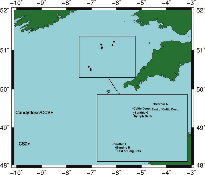
The position of this station relative to the other Shelf Sea Biogeochemistry sites can be seen from the figure below.
Sampling History
| DY008 | JC105 | DY026 | DY018 | |
|---|---|---|---|---|
| CTD casts | 1 | 3 | 6 | 29 |
| SPI camera | 4 | - | - | - |
| STD casts | - | 2 | 1 | - |
| Zooplankton net hauls | - | - | 13 | 45 |
| Box cores | - | - | 2 | 6 |
| Marine snow catcher | - | - | 3 | 16 |
| Stand Alone Pump Systems (SAPS) | - | - | 3 | 3 |
| Drifter Buoy | - | - | 1 | - |
Mooring deployments
| Latitude | Longitude | Water depth (m) | Moored instrument | Deployment date | Recovery date | Deployment cruise | Recovery cruise | Comments |
|---|---|---|---|---|---|---|---|---|
| 49.3973° | -8.6001° | 150 | Temperature chain | 26-03-2014 16:51 UTC | 19-06-2014 10:05 UTC | DY008 | JC105 | Time corresponds to anchor in |
| 49.4018° | -8.5998° | 150 | NOCL ADCP Bedframe | 27-03-2014 10:35 UTC | 19-06-2014 10:51 UTC | DY008 | JC105 | ADCP in-line mooring and bedframe |
| 49.4021° | -8.5951° | 151 | ODAS buoy | 27-03-2014 16:03 UTC | - | DY008 | - | - |
| 49.4019° | -8.6037° | 149 | Cefas SmartBuoy | 27-03-2014 19:08 UTC | 31-05-2014 12:00 UTC | DY008 | Trials cruise | Buoy broke free from tether and was recovered on a trials cruise |
| 49.4021° | -8.6032° | 146 | Cefas SmartBuoy | 19-06-2014 14:29 UTC | 21-08-2014 09:40 UTC | JC105 | DY026 | - |
| 49.4022° | -8.6022° | 147 | Temperature chain | 19-06-2014 17:08 UTC | 21-08-2014 14:50 UTC | JC105 | DY026 | - |
| 49.4024° | -8.6002° | 148 | ADCP mooring | 22-06-2014 08:52 UTC | 21-08-2014 13:39 UTC | JC105 | DY026 | ADCP in-line mooring and bedframe |
| 49.3995° | -8.5976° | 149 | NOCL ADCP Bedframe | 22-06-2014 10:47 UTC | 21-08-2014 08:30 UTC | JC105 | DY026B | - |
| 49.4022° | -8.6042° | 149 | Cefas SmartBuoy | 21-08-2014 10:31 UTC | - | DY026 | - | - |
| 49.3995° | -8.5992° | 149 | NOCL ADCP Bedframe | 22-08-2014 08:30 UTC | 20-11/2014 14:20 UTC | DY026B | DY018 | - |
| 49.4005° | -8.6060° | 151 | Temperature chain | 22-08-2014 12:50 UTC | 20-11-2014 16:27 UTC | DY026 | DY018 | - |
| 49.4011° | -8.6010° | 152 | ADCP mooring | 22-08-2014 15:09 UTC | - | DY026 | - | - |
| 49.3989° | -8.5760° | 149 | Wirewalker | 10-11-2014 10:24 UTC | 10-11-2014 10:36 UTC | DY018 | DY018 | - |
| 49.3993° | -8.6025° | 149 | Temperature chain | 21-11-2014 10:59 UTC | 04-04-2014 11:55 UTC | DY018 | DY029 | - |
| 49.3990° | -8.5977° | 149 | NOCL ADCP Bedframe | 21-11-2014 11:38 UTC | 03-08-2014 16:60 UTC | DY018 | DY034 | - |
| 49.4019° | -8.6013° | 149 | ADCP mooring | 22-11-2014 10:43 UTC | - | DY018 | - | - |
| 49.4047° | -8.6006° | 150 | Wirewalker | 22-11-2014 11:23 UTC | 26-11-2014 09:23 UTC | DY018 | DY018 | - |
| 49.3997° | -8.6030° | 147 | Temperature chain | 11-04-2015 10:22 UTC | 25-07-2015 09:57 UTC | DY029 | DY033 | - |
| 49.3974° | -8.59995° | 147 | NOCL ADCP Bedframe | 11-04-2015 11:00 UTC | 30-07-2015 17:14 UTC | DY029 | DY033 | - |
Related Fixed Station activities are detailed in Appendix 2
BODC Quality Control Flags
The following single character qualifying flags may be associated with one or more individual parameters with a data cycle:
| Flag | Description |
|---|---|
| Blank | Unqualified |
| < | Below detection limit |
| > | In excess of quoted value |
| A | Taxonomic flag for affinis (aff.) |
| B | Beginning of CTD Down/Up Cast |
| C | Taxonomic flag for confer (cf.) |
| D | Thermometric depth |
| E | End of CTD Down/Up Cast |
| G | Non-taxonomic biological characteristic uncertainty |
| H | Extrapolated value |
| I | Taxonomic flag for single species (sp.) |
| K | Improbable value - unknown quality control source |
| L | Improbable value - originator's quality control |
| M | Improbable value - BODC quality control |
| N | Null value |
| O | Improbable value - user quality control |
| P | Trace/calm |
| Q | Indeterminate |
| R | Replacement value |
| S | Estimated value |
| T | Interpolated value |
| U | Uncalibrated |
| W | Control value |
| X | Excessive difference |
SeaDataNet Quality Control Flags
The following single character qualifying flags may be associated with one or more individual parameters with a data cycle:
| Flag | Description |
|---|---|
| 0 | no quality control |
| 1 | good value |
| 2 | probably good value |
| 3 | probably bad value |
| 4 | bad value |
| 5 | changed value |
| 6 | value below detection |
| 7 | value in excess |
| 8 | interpolated value |
| 9 | missing value |
| A | value phenomenon uncertain |
| B | nominal value |
| Q | value below limit of quantification |
Appendix 1: CSS_CANDYFLOSS_TS_CHAIN3_DY026B_201408
Related series for this Data Activity are presented in the table below. Further information can be found by following the appropriate links.
If you are interested in these series, please be aware we offer a multiple file download service. Should your credentials be insufficient for automatic download, the service also offers a referral to our Enquiries Officer who may be able to negotiate access.
| Series Identifier | Data Category | Start date/time | Start position | Cruise |
|---|---|---|---|---|
| 1891776 | Hydrography time series at depth | 2014-08-18 06:00:00 | 49.40315 N, 8.60022 W | RRS Discovery DY026B |
| 1891788 | Hydrography time series at depth | 2014-08-18 06:00:00 | 49.40315 N, 8.60022 W | RRS Discovery DY026B |
| 1891807 | Hydrography time series at depth | 2014-08-18 06:00:00 | 49.40315 N, 8.60022 W | RRS Discovery DY026B |
| 1891819 | Hydrography time series at depth | 2014-08-18 06:00:00 | 49.40315 N, 8.60022 W | RRS Discovery DY026B |
| 1891820 | Hydrography time series at depth | 2014-08-18 06:00:00 | 49.40315 N, 8.60022 W | RRS Discovery DY026B |
| 1891832 | Hydrography time series at depth | 2014-08-18 06:00:00 | 49.40315 N, 8.60022 W | RRS Discovery DY026B |
| 1891844 | Hydrography time series at depth | 2014-08-18 06:00:00 | 49.40315 N, 8.60022 W | RRS Discovery DY026B |
| 1891856 | Hydrography time series at depth | 2014-08-18 06:00:00 | 49.40315 N, 8.60022 W | RRS Discovery DY026B |
| 1892509 | Hydrography time series at depth | 2014-08-18 06:00:00 | 49.40315 N, 8.60022 W | RRS Discovery DY026B |
| 1892510 | Hydrography time series at depth | 2014-08-18 06:00:00 | 49.40315 N, 8.60022 W | RRS Discovery DY026B |
| 1892522 | Hydrography time series at depth | 2014-08-18 06:00:00 | 49.40315 N, 8.60022 W | RRS Discovery DY026B |
| 1892534 | Hydrography time series at depth | 2014-08-18 06:00:00 | 49.40315 N, 8.60022 W | RRS Discovery DY026B |
| 1892546 | Hydrography time series at depth | 2014-08-18 06:00:00 | 49.40315 N, 8.60022 W | RRS Discovery DY026B |
| 1892558 | Hydrography time series at depth | 2014-08-18 06:00:00 | 49.40315 N, 8.60022 W | RRS Discovery DY026B |
| 1892571 | Hydrography time series at depth | 2014-08-18 06:00:00 | 49.40315 N, 8.60022 W | RRS Discovery DY026B |
| 1891973 | Hydrography time series at depth | 2014-08-22 11:00:01 | 49.40315 N, 8.60022 W | RRS Discovery DY026B |
| 1891985 | Hydrography time series at depth | 2014-08-22 11:00:01 | 49.40315 N, 8.60022 W | RRS Discovery DY026B |
| 1891997 | Hydrography time series at depth | 2014-08-22 11:00:01 | 49.40315 N, 8.60022 W | RRS Discovery DY026B |
| 1892000 | Hydrography time series at depth | 2014-08-22 11:00:01 | 49.40315 N, 8.60022 W | RRS Discovery DY026B |
| 1892221 | Hydrography time series at depth | 2014-08-22 11:00:02 | 49.40315 N, 8.60022 W | RRS Discovery DY026B |
| 1892208 | Hydrography time series at depth | 2014-08-22 11:00:03 | 49.40315 N, 8.60022 W | RRS Discovery DY026B |
| 1892233 | Hydrography time series at depth | 2014-08-22 11:00:03 | 49.40315 N, 8.60022 W | RRS Discovery DY026B |
Appendix 2: Shelf Sea Biogeochemistry Fixed Station Candyfloss/CCS
Related series for this Fixed Station are presented in the table below. Further information can be found by following the appropriate links.
If you are interested in these series, please be aware we offer a multiple file download service. Should your credentials be insufficient for automatic download, the service also offers a referral to our Enquiries Officer who may be able to negotiate access.
| Series Identifier | Data Category | Start date/time | Start position | Cruise |
|---|---|---|---|---|
| 1891623 | Hydrography time series at depth | 2014-03-26 00:00:00 | 49.39952 N, 8.60384 W | RRS Discovery DY008 |
| 1891635 | Hydrography time series at depth | 2014-03-26 00:00:00 | 49.39952 N, 8.60384 W | RRS Discovery DY008 |
| 1891647 | Hydrography time series at depth | 2014-03-26 00:00:00 | 49.39952 N, 8.60384 W | RRS Discovery DY008 |
| 1891659 | Hydrography time series at depth | 2014-03-26 00:00:00 | 49.39952 N, 8.60384 W | RRS Discovery DY008 |
| 1891660 | Hydrography time series at depth | 2014-03-26 00:00:00 | 49.39952 N, 8.60384 W | RRS Discovery DY008 |
| 1891672 | Hydrography time series at depth | 2014-03-26 00:00:00 | 49.39952 N, 8.60384 W | RRS Discovery DY008 |
| 1891684 | Hydrography time series at depth | 2014-03-26 00:00:00 | 49.39952 N, 8.60384 W | RRS Discovery DY008 |
| 1892325 | Hydrography time series at depth | 2014-03-26 00:00:00 | 49.39952 N, 8.60384 W | RRS Discovery DY008 |
| 1892337 | Hydrography time series at depth | 2014-03-26 00:00:00 | 49.39952 N, 8.60384 W | RRS Discovery DY008 |
| 1892349 | Hydrography time series at depth | 2014-03-26 00:00:00 | 49.39952 N, 8.60384 W | RRS Discovery DY008 |
| 1892350 | Hydrography time series at depth | 2014-03-26 00:00:00 | 49.39952 N, 8.60384 W | RRS Discovery DY008 |
| 1892362 | Hydrography time series at depth | 2014-03-26 00:00:00 | 49.39952 N, 8.60384 W | RRS Discovery DY008 |
| 1892374 | Hydrography time series at depth | 2014-03-26 00:00:00 | 49.39952 N, 8.60384 W | RRS Discovery DY008 |
| 1892386 | Hydrography time series at depth | 2014-03-26 00:00:00 | 49.39952 N, 8.60384 W | RRS Discovery DY008 |
| 1892398 | Hydrography time series at depth | 2014-03-26 00:00:00 | 49.39952 N, 8.60384 W | RRS Discovery DY008 |
| 1891881 | Hydrography time series at depth | 2014-03-26 14:00:01 | 49.39952 N, 8.60384 W | RRS Discovery DY008 |
| 1891893 | Hydrography time series at depth | 2014-03-26 14:00:01 | 49.39952 N, 8.60384 W | RRS Discovery DY008 |
| 1891900 | Hydrography time series at depth | 2014-03-26 14:00:01 | 49.39952 N, 8.60384 W | RRS Discovery DY008 |
| 1891912 | Hydrography time series at depth | 2014-03-26 14:00:01 | 49.39952 N, 8.60384 W | RRS Discovery DY008 |
| 1892128 | Hydrography time series at depth | 2014-03-26 14:00:02 | 49.39952 N, 8.60384 W | RRS Discovery DY008 |
| 1892116 | Hydrography time series at depth | 2014-03-26 14:00:03 | 49.39952 N, 8.60384 W | RRS Discovery DY008 |
| 1892141 | Hydrography time series at depth | 2014-03-26 14:00:03 | 49.39952 N, 8.60384 W | RRS Discovery DY008 |
| 1892104 | Hydrography time series at depth | 2014-03-26 17:00:03 | 49.39914 N, 8.60017 W | RRS Discovery DY008 |
| 1965722 | Currents -subsurface Eulerian | 2014-03-26 19:30:08 | 49.4018 N, 8.5998 W | RRS Discovery DY008 |
| 1371573 | CTD or STD cast | 2014-03-27 19:38:00 | 49.40252 N, 8.6032 W | RRS Discovery DY008 |
| 1336692 | Water sample data | 2014-03-27 19:44:00 | 49.40253 N, 8.60318 W | RRS Discovery DY008 |
| 2117536 | Water sample data | 2014-03-27 19:44:00 | 49.40253 N, 8.60318 W | RRS Discovery DY008 |
| 2119094 | Water sample data | 2014-03-27 19:44:00 | 49.40253 N, 8.60318 W | RRS Discovery DY008 |
| 1891696 | Hydrography time series at depth | 2014-06-18 08:00:00 | 49.40021 N, 8.60212 W | RRS James Cook JC105 |
| 1891703 | Hydrography time series at depth | 2014-06-18 08:00:00 | 49.40021 N, 8.60212 W | RRS James Cook JC105 |
| 1891715 | Hydrography time series at depth | 2014-06-18 08:00:00 | 49.40021 N, 8.60212 W | RRS James Cook JC105 |
| 1891727 | Hydrography time series at depth | 2014-06-18 08:00:00 | 49.40021 N, 8.60212 W | RRS James Cook JC105 |
| 1891739 | Hydrography time series at depth | 2014-06-18 08:00:00 | 49.40021 N, 8.60212 W | RRS James Cook JC105 |
| 1891740 | Hydrography time series at depth | 2014-06-18 08:00:00 | 49.40021 N, 8.60212 W | RRS James Cook JC105 |
| 1891752 | Hydrography time series at depth | 2014-06-18 08:00:00 | 49.40021 N, 8.60212 W | RRS James Cook JC105 |
| 1891764 | Hydrography time series at depth | 2014-06-18 08:00:00 | 49.40021 N, 8.60212 W | RRS James Cook JC105 |
| 1892405 | Hydrography time series at depth | 2014-06-18 08:00:00 | 49.40021 N, 8.60212 W | RRS James Cook JC105 |
| 1892417 | Hydrography time series at depth | 2014-06-18 08:00:00 | 49.40021 N, 8.60212 W | RRS James Cook JC105 |
| 1892429 | Hydrography time series at depth | 2014-06-18 08:00:00 | 49.40021 N, 8.60212 W | RRS James Cook JC105 |
| 1892430 | Hydrography time series at depth | 2014-06-18 08:00:00 | 49.40021 N, 8.60212 W | RRS James Cook JC105 |
| 1892442 | Hydrography time series at depth | 2014-06-18 08:00:00 | 49.40021 N, 8.60212 W | RRS James Cook JC105 |
| 1892454 | Hydrography time series at depth | 2014-06-18 08:00:00 | 49.40021 N, 8.60212 W | RRS James Cook JC105 |
| 1892466 | Hydrography time series at depth | 2014-06-18 08:00:00 | 49.40021 N, 8.60212 W | RRS James Cook JC105 |
| 1892478 | Hydrography time series at depth | 2014-06-18 08:00:00 | 49.40021 N, 8.60212 W | RRS James Cook JC105 |
| 1372748 | CTD or STD cast | 2014-06-19 08:13:00 | 49.40363 N, 8.6051 W | RRS James Cook JC105 |
| 2103842 | Water sample data | 2014-06-19 08:19:00 | 49.40368 N, 8.60512 W | RRS James Cook JC105 |
| 2108103 | Water sample data | 2014-06-19 08:19:00 | 49.40368 N, 8.60512 W | RRS James Cook JC105 |
| 2143113 | Water sample data | 2014-06-19 08:19:00 | 49.40368 N, 8.60512 W | RRS James Cook JC105 |
| 1891924 | Hydrography time series at depth | 2014-06-19 16:00:01 | 49.40021 N, 8.60212 W | RRS James Cook JC105 |
| 1891936 | Hydrography time series at depth | 2014-06-19 16:00:01 | 49.40021 N, 8.60212 W | RRS James Cook JC105 |
| 1891948 | Hydrography time series at depth | 2014-06-19 16:00:01 | 49.40021 N, 8.60212 W | RRS James Cook JC105 |
| 1891961 | Hydrography time series at depth | 2014-06-19 16:00:01 | 49.40021 N, 8.60212 W | RRS James Cook JC105 |
| 1892177 | Hydrography time series at depth | 2014-06-19 16:00:01 | 49.40021 N, 8.60212 W | RRS James Cook JC105 |
| 1892165 | Hydrography time series at depth | 2014-06-19 16:00:03 | 49.40021 N, 8.60212 W | RRS James Cook JC105 |
| 1892189 | Hydrography time series at depth | 2014-06-19 16:00:03 | 49.40021 N, 8.60212 W | RRS James Cook JC105 |
| 1372761 | CTD or STD cast | 2014-06-19 17:58:00 | 49.40052 N, 8.60737 W | RRS James Cook JC105 |
| 2103854 | Water sample data | 2014-06-19 17:58:00 | 49.40052 N, 8.60751 W | RRS James Cook JC105 |
| 2108115 | Water sample data | 2014-06-19 17:58:00 | 49.40052 N, 8.60751 W | RRS James Cook JC105 |
| 2143125 | Water sample data | 2014-06-19 17:58:00 | 49.40052 N, 8.60751 W | RRS James Cook JC105 |
| 1892153 | Hydrography time series at depth | 2014-06-22 10:30:03 | 49.39955 N, 8.5976 W | RRS James Cook JC105 |
| 1965734 | Currents -subsurface Eulerian | 2014-06-22 10:56:42 | 49.3995 N, 8.5976 W | RRS James Cook JC105 |
| 1372970 | CTD or STD cast | 2014-06-22 11:14:00 | 49.40063 N, 8.60095 W | RRS James Cook JC105 |
| 2080269 | Water sample data | 2014-06-22 11:19:30 | 49.40062 N, 8.60106 W | RRS James Cook JC105 |
| 2103958 | Water sample data | 2014-06-22 11:19:30 | 49.40062 N, 8.60106 W | RRS James Cook JC105 |
| 2108219 | Water sample data | 2014-06-22 11:19:30 | 49.40062 N, 8.60106 W | RRS James Cook JC105 |
| 2143217 | Water sample data | 2014-06-22 11:19:30 | 49.40062 N, 8.60106 W | RRS James Cook JC105 |
| 1373008 | CTD or STD cast | 2014-08-05 05:10:00 | 49.38633 N, 8.61883 W | RRS Discovery DY026A |
| 2127463 | Water sample data | 2014-08-05 05:34:00 | 49.38659 N, 8.61882 W | RRS Discovery DY026A |
| 1373021 | CTD or STD cast | 2014-08-05 11:03:00 | 49.38333 N, 8.61167 W | RRS Discovery DY026A |
| 2118122 | Water sample data | 2014-08-05 11:19:30 | 49.38353 N, 8.61131 W | RRS Discovery DY026A |
| 2127475 | Water sample data | 2014-08-05 11:19:30 | 49.38353 N, 8.61131 W | RRS Discovery DY026A |
| 1373033 | CTD or STD cast | 2014-08-05 16:10:00 | 49.37167 N, 8.608 W | RRS Discovery DY026A |
| 2127487 | Water sample data | 2014-08-05 17:22:00 | 49.37186 N, 8.60776 W | RRS Discovery DY026A |
| 1891776 | Hydrography time series at depth | 2014-08-18 06:00:00 | 49.40315 N, 8.60022 W | RRS Discovery DY026B |
| 1891788 | Hydrography time series at depth | 2014-08-18 06:00:00 | 49.40315 N, 8.60022 W | RRS Discovery DY026B |
| 1891807 | Hydrography time series at depth | 2014-08-18 06:00:00 | 49.40315 N, 8.60022 W | RRS Discovery DY026B |
| 1891819 | Hydrography time series at depth | 2014-08-18 06:00:00 | 49.40315 N, 8.60022 W | RRS Discovery DY026B |
| 1891820 | Hydrography time series at depth | 2014-08-18 06:00:00 | 49.40315 N, 8.60022 W | RRS Discovery DY026B |
| 1891832 | Hydrography time series at depth | 2014-08-18 06:00:00 | 49.40315 N, 8.60022 W | RRS Discovery DY026B |
| 1891844 | Hydrography time series at depth | 2014-08-18 06:00:00 | 49.40315 N, 8.60022 W | RRS Discovery DY026B |
| 1891856 | Hydrography time series at depth | 2014-08-18 06:00:00 | 49.40315 N, 8.60022 W | RRS Discovery DY026B |
| 1892509 | Hydrography time series at depth | 2014-08-18 06:00:00 | 49.40315 N, 8.60022 W | RRS Discovery DY026B |
| 1892510 | Hydrography time series at depth | 2014-08-18 06:00:00 | 49.40315 N, 8.60022 W | RRS Discovery DY026B |
| 1892522 | Hydrography time series at depth | 2014-08-18 06:00:00 | 49.40315 N, 8.60022 W | RRS Discovery DY026B |
| 1892534 | Hydrography time series at depth | 2014-08-18 06:00:00 | 49.40315 N, 8.60022 W | RRS Discovery DY026B |
| 1892546 | Hydrography time series at depth | 2014-08-18 06:00:00 | 49.40315 N, 8.60022 W | RRS Discovery DY026B |
| 1892558 | Hydrography time series at depth | 2014-08-18 06:00:00 | 49.40315 N, 8.60022 W | RRS Discovery DY026B |
| 1892571 | Hydrography time series at depth | 2014-08-18 06:00:00 | 49.40315 N, 8.60022 W | RRS Discovery DY026B |
| 1373395 | CTD or STD cast | 2014-08-21 11:47:00 | 49.39765 N, 8.59462 W | RRS Discovery DY026B |
| 2118226 | Water sample data | 2014-08-21 12:00:00 | 49.39764 N, 8.59464 W | RRS Discovery DY026B |
| 2127820 | Water sample data | 2014-08-21 12:00:00 | 49.39764 N, 8.59464 W | RRS Discovery DY026B |
| 1892190 | Hydrography time series at depth | 2014-08-22 08:10:03 | 49.39998 N, 8.6031 W | RRS Discovery DY026B |
| 1965746 | Currents -subsurface Eulerian | 2014-08-22 08:30:28 | 49.3995 N, 8.5992 W | RRS Discovery DY026B |
| 1373402 | CTD or STD cast | 2014-08-22 08:42:00 | 49.39955 N, 8.59947 W | RRS Discovery DY026B |
| 2127832 | Water sample data | 2014-08-22 08:55:00 | 49.39956 N, 8.59947 W | RRS Discovery DY026B |
| 1891973 | Hydrography time series at depth | 2014-08-22 11:00:01 | 49.40315 N, 8.60022 W | RRS Discovery DY026B |
| 1891985 | Hydrography time series at depth | 2014-08-22 11:00:01 | 49.40315 N, 8.60022 W | RRS Discovery DY026B |
| 1891997 | Hydrography time series at depth | 2014-08-22 11:00:01 | 49.40315 N, 8.60022 W | RRS Discovery DY026B |
| 1892000 | Hydrography time series at depth | 2014-08-22 11:00:01 | 49.40315 N, 8.60022 W | RRS Discovery DY026B |
| 1892221 | Hydrography time series at depth | 2014-08-22 11:00:02 | 49.40315 N, 8.60022 W | RRS Discovery DY026B |
| 1892208 | Hydrography time series at depth | 2014-08-22 11:00:03 | 49.40315 N, 8.60022 W | RRS Discovery DY026B |
| 1892233 | Hydrography time series at depth | 2014-08-22 11:00:03 | 49.40315 N, 8.60022 W | RRS Discovery DY026B |
| 1373414 | CTD or STD cast | 2014-08-22 17:38:00 | 49.39723 N, 8.59747 W | RRS Discovery DY026B |
| 2127844 | Water sample data | 2014-08-22 17:45:30 | 49.39723 N, 8.59747 W | RRS Discovery DY026B |
| 1371628 | CTD or STD cast | 2014-11-10 05:12:00 | 49.40132 N, 8.5802 W | RRS Discovery DY018 (GApr04) |
| 2117573 | Water sample data | 2014-11-10 05:26:00 | 49.40095 N, 8.57876 W | RRS Discovery DY018 (GApr04) |
| 2119764 | Water sample data | 2014-11-10 05:26:00 | 49.40095 N, 8.57876 W | RRS Discovery DY018 (GApr04) |
| 2126693 | Water sample data | 2014-11-10 05:26:00 | 49.40095 N, 8.57876 W | RRS Discovery DY018 (GApr04) |
| 2136510 | Water sample data | 2014-11-10 05:26:00 | 49.40095 N, 8.57876 W | RRS Discovery DY018 (GApr04) |
| 1371641 | CTD or STD cast | 2014-11-10 09:11:00 | 49.40013 N, 8.57592 W | RRS Discovery DY018 (GApr04) |
| 1371653 | CTD or STD cast | 2014-11-10 12:28:00 | 49.39842 N, 8.5765 W | RRS Discovery DY018 (GApr04) |
| 2117585 | Water sample data | 2014-11-10 12:44:00 | 49.39843 N, 8.57646 W | RRS Discovery DY018 (GApr04) |
| 2126700 | Water sample data | 2014-11-10 12:44:00 | 49.39843 N, 8.57646 W | RRS Discovery DY018 (GApr04) |
| 2136522 | Water sample data | 2014-11-10 12:44:00 | 49.39843 N, 8.57646 W | RRS Discovery DY018 (GApr04) |
| 1372355 | CTD or STD cast | 2014-11-10 16:35:00 | 49.39997 N, 8.57225 W | RRS Discovery DY018 (GApr04) |
| 1371665 | CTD or STD cast | 2014-11-11 09:18:00 | 49.39833 N, 8.57872 W | RRS Discovery DY018 (GApr04) |
| 1372367 | CTD or STD cast | 2014-11-11 10:55:00 | 49.39835 N, 8.5787 W | RRS Discovery DY018 (GApr04) |
| 2119985 | Water sample data | 2014-11-11 11:04:00 | 49.39835 N, 8.57871 W | RRS Discovery DY018 (GApr04) |
| 2121375 | Water sample data | 2014-11-11 11:04:00 | 49.39835 N, 8.57871 W | RRS Discovery DY018 (GApr04) |
| 2126933 | Water sample data | 2014-11-11 11:04:00 | 49.39835 N, 8.57871 W | RRS Discovery DY018 (GApr04) |
| 1371677 | CTD or STD cast | 2014-11-11 12:14:00 | 49.39833 N, 8.5787 W | RRS Discovery DY018 (GApr04) |
| 2117597 | Water sample data | 2014-11-11 12:34:00 | 49.39834 N, 8.57871 W | RRS Discovery DY018 (GApr04) |
| 2119776 | Water sample data | 2014-11-11 12:34:00 | 49.39834 N, 8.57871 W | RRS Discovery DY018 (GApr04) |
| 2126712 | Water sample data | 2014-11-11 12:34:00 | 49.39834 N, 8.57871 W | RRS Discovery DY018 (GApr04) |
| 2136534 | Water sample data | 2014-11-11 12:34:00 | 49.39834 N, 8.57871 W | RRS Discovery DY018 (GApr04) |
| 1371689 | CTD or STD cast | 2014-11-11 14:08:00 | 49.39832 N, 8.5793 W | RRS Discovery DY018 (GApr04) |
| 1371690 | CTD or STD cast | 2014-11-11 18:12:00 | 49.39932 N, 8.57738 W | RRS Discovery DY018 (GApr04) |
| 1371708 | CTD or STD cast | 2014-11-12 05:15:00 | 49.39878 N, 8.57657 W | RRS Discovery DY018 (GApr04) |
| 2117604 | Water sample data | 2014-11-12 05:27:00 | 49.39877 N, 8.57656 W | RRS Discovery DY018 (GApr04) |
| 2126724 | Water sample data | 2014-11-12 05:27:00 | 49.39877 N, 8.57656 W | RRS Discovery DY018 (GApr04) |
| 2136546 | Water sample data | 2014-11-12 05:27:00 | 49.39877 N, 8.57656 W | RRS Discovery DY018 (GApr04) |
| 1371721 | CTD or STD cast | 2014-11-12 09:11:00 | 49.39908 N, 8.57658 W | RRS Discovery DY018 (GApr04) |
| 1372379 | CTD or STD cast | 2014-11-12 10:56:00 | 49.39938 N, 8.57462 W | RRS Discovery DY018 (GApr04) |
| 2119997 | Water sample data | 2014-11-12 10:58:30 | 49.39938 N, 8.57464 W | RRS Discovery DY018 (GApr04) |
| 2121387 | Water sample data | 2014-11-12 10:58:30 | 49.39938 N, 8.57464 W | RRS Discovery DY018 (GApr04) |
| 2126945 | Water sample data | 2014-11-12 10:58:30 | 49.39938 N, 8.57464 W | RRS Discovery DY018 (GApr04) |
| 1371733 | CTD or STD cast | 2014-11-12 12:30:00 | 49.3994 N, 8.57402 W | RRS Discovery DY018 (GApr04) |
| 2117616 | Water sample data | 2014-11-12 12:52:30 | 49.39943 N, 8.57404 W | RRS Discovery DY018 (GApr04) |
| 2119788 | Water sample data | 2014-11-12 12:52:30 | 49.39943 N, 8.57404 W | RRS Discovery DY018 (GApr04) |
| 2126736 | Water sample data | 2014-11-12 12:52:30 | 49.39943 N, 8.57404 W | RRS Discovery DY018 (GApr04) |
| 2136558 | Water sample data | 2014-11-12 12:52:30 | 49.39943 N, 8.57404 W | RRS Discovery DY018 (GApr04) |
| 1892583 | Hydrography time series at depth | 2014-11-20 06:00:00 | 49.398 N, 8.60783 W | RRS Discovery DY018 (GApr04) |
| 1892595 | Hydrography time series at depth | 2014-11-20 06:00:00 | 49.398 N, 8.60783 W | RRS Discovery DY018 (GApr04) |
| 1892602 | Hydrography time series at depth | 2014-11-20 06:00:00 | 49.398 N, 8.60783 W | RRS Discovery DY018 (GApr04) |
| 1892614 | Hydrography time series at depth | 2014-11-20 06:00:00 | 49.398 N, 8.60783 W | RRS Discovery DY018 (GApr04) |
| 1892626 | Hydrography time series at depth | 2014-11-20 06:00:00 | 49.398 N, 8.60783 W | RRS Discovery DY018 (GApr04) |
| 1892638 | Hydrography time series at depth | 2014-11-20 06:00:00 | 49.398 N, 8.60783 W | RRS Discovery DY018 (GApr04) |
| 1892651 | Hydrography time series at depth | 2014-11-20 06:00:00 | 49.398 N, 8.60783 W | RRS Discovery DY018 (GApr04) |
| 1892663 | Hydrography time series at depth | 2014-11-20 06:00:00 | 49.398 N, 8.60783 W | RRS Discovery DY018 (GApr04) |
| 1892779 | Hydrography time series at depth | 2014-11-20 06:00:00 | 49.398 N, 8.60783 W | RRS Discovery DY018 (GApr04) |
| 1892780 | Hydrography time series at depth | 2014-11-20 06:00:00 | 49.398 N, 8.60783 W | RRS Discovery DY018 (GApr04) |
| 1892792 | Hydrography time series at depth | 2014-11-20 06:00:00 | 49.398 N, 8.60783 W | RRS Discovery DY018 (GApr04) |
| 1892811 | Hydrography time series at depth | 2014-11-20 06:00:00 | 49.398 N, 8.60783 W | RRS Discovery DY018 (GApr04) |
| 1892823 | Hydrography time series at depth | 2014-11-20 06:00:00 | 49.398 N, 8.60783 W | RRS Discovery DY018 (GApr04) |
| 1892835 | Hydrography time series at depth | 2014-11-20 06:00:00 | 49.398 N, 8.60783 W | RRS Discovery DY018 (GApr04) |
| 1892847 | Hydrography time series at depth | 2014-11-20 06:00:00 | 49.398 N, 8.60783 W | RRS Discovery DY018 (GApr04) |
| 1372078 | CTD or STD cast | 2014-11-20 09:32:00 | 49.39257 N, 8.59262 W | RRS Discovery DY018 (GApr04) |
| 1892036 | Hydrography time series at depth | 2014-11-21 06:00:01 | 49.398 N, 8.60783 W | RRS Discovery DY018 (GApr04) |
| 1892048 | Hydrography time series at depth | 2014-11-21 06:00:01 | 49.398 N, 8.60783 W | RRS Discovery DY018 (GApr04) |
| 1892257 | Hydrography time series at depth | 2014-11-21 06:00:01 | 49.398 N, 8.60783 W | RRS Discovery DY018 (GApr04) |
| 1892269 | Hydrography time series at depth | 2014-11-21 06:00:01 | 49.398 N, 8.60783 W | RRS Discovery DY018 (GApr04) |
| 1892270 | Hydrography time series at depth | 2014-11-21 06:00:01 | 49.398 N, 8.60783 W | RRS Discovery DY018 (GApr04) |
| 1372091 | CTD or STD cast | 2014-11-21 08:43:00 | 49.40658 N, 8.59923 W | RRS Discovery DY018 (GApr04) |
| 1892245 | Hydrography time series at depth | 2014-11-21 09:10:03 | 49.39903 N, 8.59772 W | RRS Discovery DY018 (GApr04) |
| 1891868 | Hydrography time series at depth | 2014-11-21 09:45:00 | 49.398 N, 8.60783 W | RRS Discovery DY018 (GApr04) |
| 1965758 | Currents -subsurface Eulerian | 2014-11-21 11:50:17 | 49.399 N, 8.5977 W | RRS Discovery DY018 (GApr04) |
| 1372109 | CTD or STD cast | 2014-11-21 18:18:00 | 49.39898 N, 8.58423 W | RRS Discovery DY018 (GApr04) |
| 1372110 | CTD or STD cast | 2014-11-22 05:05:00 | 49.38768 N, 8.58718 W | RRS Discovery DY018 (GApr04) |
| 2117757 | Water sample data | 2014-11-22 05:16:00 | 49.39355 N, 8.58717 W | RRS Discovery DY018 (GApr04) |
| 2126865 | Water sample data | 2014-11-22 05:16:00 | 49.39355 N, 8.58717 W | RRS Discovery DY018 (GApr04) |
| 2136675 | Water sample data | 2014-11-22 05:16:00 | 49.39355 N, 8.58717 W | RRS Discovery DY018 (GApr04) |
| 1372122 | CTD or STD cast | 2014-11-22 06:52:00 | 49.39352 N, 8.58718 W | RRS Discovery DY018 (GApr04) |
| 1372134 | CTD or STD cast | 2014-11-22 08:05:00 | 49.39342 N, 8.58722 W | RRS Discovery DY018 (GApr04) |
| 2119868 | Water sample data | 2014-11-22 08:09:00 | 49.39343 N, 8.58723 W | RRS Discovery DY018 (GApr04) |
| 1372263 | CTD or STD cast | 2014-11-25 05:11:00 | 49.40117 N, 8.5835 W | RRS Discovery DY018 (GApr04) |
| 2117769 | Water sample data | 2014-11-25 05:21:30 | 49.40168 N, 8.58234 W | RRS Discovery DY018 (GApr04) |
| 2119900 | Water sample data | 2014-11-25 05:21:30 | 49.40168 N, 8.58234 W | RRS Discovery DY018 (GApr04) |
| 2126877 | Water sample data | 2014-11-25 05:21:30 | 49.40168 N, 8.58234 W | RRS Discovery DY018 (GApr04) |
| 2136687 | Water sample data | 2014-11-25 05:21:30 | 49.40168 N, 8.58234 W | RRS Discovery DY018 (GApr04) |
| 1372275 | CTD or STD cast | 2014-11-25 12:17:00 | 49.3992 N, 8.58198 W | RRS Discovery DY018 (GApr04) |
| 2117770 | Water sample data | 2014-11-25 12:27:00 | 49.3992 N, 8.58198 W | RRS Discovery DY018 (GApr04) |
| 2119912 | Water sample data | 2014-11-25 12:27:00 | 49.3992 N, 8.58198 W | RRS Discovery DY018 (GApr04) |
| 2126889 | Water sample data | 2014-11-25 12:27:00 | 49.3992 N, 8.58198 W | RRS Discovery DY018 (GApr04) |
| 2136699 | Water sample data | 2014-11-25 12:27:00 | 49.3992 N, 8.58198 W | RRS Discovery DY018 (GApr04) |
| 1372287 | CTD or STD cast | 2014-11-25 15:41:00 | 49.41468 N, 8.59318 W | RRS Discovery DY018 (GApr04) |
| 2119924 | Water sample data | 2014-11-25 15:46:30 | 49.41469 N, 8.59317 W | RRS Discovery DY018 (GApr04) |
| 1372299 | CTD or STD cast | 2014-11-26 08:05:00 | 49.40572 N, 8.5958 W | RRS Discovery DY018 (GApr04) |
| 2119936 | Water sample data | 2014-11-26 08:10:30 | 49.40572 N, 8.5958 W | RRS Discovery DY018 (GApr04) |
| 1892024 | Hydrography time series at depth | 2014-11-26 10:10:01 | 49.398 N, 8.60783 W | RRS Discovery DY018 (GApr04) |
| 1892012 | Hydrography time series at depth | 2014-11-27 13:45:01 | 49.398 N, 8.60783 W | RRS Discovery DY018 (GApr04) |
| 2137710 | Water sample data | 2014-11-29 13:34:00 | 49.40473 N, 8.58419 W | RRS Discovery DY018 (GApr04) |
| 1372619 | CTD or STD cast | 2014-11-29 14:13:00 | 49.40423 N, 8.58532 W | RRS Discovery DY018 (GApr04) |
| 2118017 | Water sample data | 2014-11-29 14:19:30 | 49.40423 N, 8.58532 W | RRS Discovery DY018 (GApr04) |
| 2120187 | Water sample data | 2014-11-29 14:19:30 | 49.40423 N, 8.58532 W | RRS Discovery DY018 (GApr04) |
| 2121627 | Water sample data | 2014-11-29 14:19:30 | 49.40423 N, 8.58532 W | RRS Discovery DY018 (GApr04) |
| 2127174 | Water sample data | 2014-11-29 14:19:30 | 49.40423 N, 8.58532 W | RRS Discovery DY018 (GApr04) |
| 2137691 | Water sample data | 2014-11-29 14:19:30 | 49.40423 N, 8.58532 W | RRS Discovery DY018 (GApr04) |
| 1372620 | CTD or STD cast | 2014-11-30 10:07:00 | 49.40512 N, 8.57657 W | RRS Discovery DY018 (GApr04) |
| 1624393 | CTD or STD cast | 2015-03-22 06:42:00 | 49.4035 N, 8.59667 W | RRS Discovery DY021 |
| 1624400 | CTD or STD cast | 2015-03-22 07:42:00 | 49.3998 N, 8.59992 W | RRS Discovery DY021 |
| 1624553 | CTD or STD cast | 2015-03-22 09:07:00 | 49.39983 N, 8.6002 W | RRS Discovery DY021 |
| 2119696 | Water sample data | 2015-03-22 09:16:00 | 49.39984 N, 8.60019 W | RRS Discovery DY021 |
| 2121688 | Water sample data | 2015-03-22 09:16:00 | 49.39984 N, 8.60019 W | RRS Discovery DY021 |
| 2127426 | Water sample data | 2015-03-22 09:16:00 | 49.39984 N, 8.60019 W | RRS Discovery DY021 |
| 2134355 | Water sample data | 2015-03-22 09:16:00 | 49.39984 N, 8.60019 W | RRS Discovery DY021 |
| 1624412 | CTD or STD cast | 2015-03-22 10:24:00 | 49.39987 N, 8.6002 W | RRS Discovery DY021 |
| 2135900 | Water sample data | 2015-03-22 10:26:30 | 49.39984 N, 8.60019 W | RRS Discovery DY021 |
| 1624424 | CTD or STD cast | 2015-03-22 12:09:00 | 49.4068 N, 8.59272 W | RRS Discovery DY021 |
| 2118078 | Water sample data | 2015-03-22 12:17:30 | 49.40658 N, 8.59401 W | RRS Discovery DY021 |
| 2127334 | Water sample data | 2015-03-22 12:17:30 | 49.40658 N, 8.59401 W | RRS Discovery DY021 |
| 2135912 | Water sample data | 2015-03-22 12:17:30 | 49.40658 N, 8.59401 W | RRS Discovery DY021 |
| 1624436 | CTD or STD cast | 2015-03-22 15:08:00 | 49.4121 N, 8.60152 W | RRS Discovery DY021 |
| 1624448 | CTD or STD cast | 2015-03-23 13:12:00 | 49.41003 N, 8.59638 W | RRS Discovery DY021 |
| 2127346 | Water sample data | 2015-03-23 13:21:30 | 49.41001 N, 8.59634 W | RRS Discovery DY021 |
| 2135924 | Water sample data | 2015-03-23 13:21:30 | 49.41001 N, 8.59634 W | RRS Discovery DY021 |
| 2118576 | Water sample data | 2015-04-02 11:04:00 | 48.20486 N, 10.05389 W | RRS Discovery DY029 (GApr04) |
| 1625998 | CTD or STD cast | 2015-04-03 14:30:00 | 49.38993 N, 8.59247 W | RRS Discovery DY029 (GApr04) |
| 1627016 | CTD or STD cast | 2015-04-03 15:38:00 | 49.38983 N, 8.59233 W | RRS Discovery DY029 (GApr04) |
| 1626001 | CTD or STD cast | 2015-04-03 16:46:00 | 49.38992 N, 8.59245 W | RRS Discovery DY029 (GApr04) |
| 1626013 | CTD or STD cast | 2015-04-04 02:05:00 | 49.38952 N, 8.5932 W | RRS Discovery DY029 (GApr04) |
| 2118251 | Water sample data | 2015-04-04 02:23:00 | 49.38951 N, 8.59321 W | RRS Discovery DY029 (GApr04) |
| 2136731 | Water sample data | 2015-04-04 02:23:00 | 49.38951 N, 8.59321 W | RRS Discovery DY029 (GApr04) |
| 1626025 | CTD or STD cast | 2015-04-04 07:09:00 | 49.39268 N, 8.56323 W | RRS Discovery DY029 (GApr04) |
| 1626037 | CTD or STD cast | 2015-04-04 12:49:00 | 49.39783 N, 8.6045 W | RRS Discovery DY029 (GApr04) |
| 2118263 | Water sample data | 2015-04-04 13:07:30 | 49.39794 N, 8.60401 W | RRS Discovery DY029 (GApr04) |
| 2136743 | Water sample data | 2015-04-04 13:07:30 | 49.39794 N, 8.60401 W | RRS Discovery DY029 (GApr04) |
| 1626049 | CTD or STD cast | 2015-04-04 15:11:00 | 49.39633 N, 8.60917 W | RRS Discovery DY029 (GApr04) |
| 1626050 | CTD or STD cast | 2015-04-05 07:56:00 | 49.3878 N, 8.56087 W | RRS Discovery DY029 (GApr04) |
| 1971371 | Hydrography vertical profile | 2015-04-05 14:12:05 | 49.40465 N, 8.597 W | RRS Discovery DY029 (GApr04) |
| 1626062 | CTD or STD cast | 2015-04-05 14:52:00 | 49.40542 N, 8.59513 W | RRS Discovery DY029 (GApr04) |
| 2118275 | Water sample data | 2015-04-05 15:14:00 | 49.40549 N, 8.59515 W | RRS Discovery DY029 (GApr04) |
| 2136755 | Water sample data | 2015-04-05 15:14:00 | 49.40549 N, 8.59515 W | RRS Discovery DY029 (GApr04) |
| 1627028 | CTD or STD cast | 2015-04-05 18:41:00 | 49.40943 N, 8.58985 W | RRS Discovery DY029 (GApr04) |
| 1626074 | CTD or STD cast | 2015-04-06 02:14:00 | 49.40517 N, 8.58817 W | RRS Discovery DY029 (GApr04) |
| 2118287 | Water sample data | 2015-04-06 02:30:30 | 49.40512 N, 8.58816 W | RRS Discovery DY029 (GApr04) |
| 2136767 | Water sample data | 2015-04-06 02:30:30 | 49.40512 N, 8.58816 W | RRS Discovery DY029 (GApr04) |
| 1626338 | CTD or STD cast | 2015-04-11 02:10:00 | 49.39707 N, 8.58157 W | RRS Discovery DY029 (GApr04) |
| 2118318 | Water sample data | 2015-04-11 02:23:30 | 49.39698 N, 8.58163 W | RRS Discovery DY029 (GApr04) |
| 2136823 | Water sample data | 2015-04-11 02:23:30 | 49.39698 N, 8.58163 W | RRS Discovery DY029 (GApr04) |
| 1892061 | Hydrography time series at depth | 2015-04-11 10:25:00 | 49.40188 N, 8.60415 W | RRS Discovery DY029 (GApr04) |
| 1892085 | Hydrography time series at depth | 2015-04-11 10:25:00 | 49.40188 N, 8.60415 W | RRS Discovery DY029 (GApr04) |
| 1892675 | Hydrography time series at depth | 2015-04-11 10:25:00 | 49.40188 N, 8.60415 W | RRS Discovery DY029 (GApr04) |
| 1892687 | Hydrography time series at depth | 2015-04-11 10:25:00 | 49.40188 N, 8.60415 W | RRS Discovery DY029 (GApr04) |
| 1892699 | Hydrography time series at depth | 2015-04-11 10:25:00 | 49.40188 N, 8.60415 W | RRS Discovery DY029 (GApr04) |
| 1892706 | Hydrography time series at depth | 2015-04-11 10:25:00 | 49.40188 N, 8.60415 W | RRS Discovery DY029 (GApr04) |
| 1892718 | Hydrography time series at depth | 2015-04-11 10:25:00 | 49.40188 N, 8.60415 W | RRS Discovery DY029 (GApr04) |
| 1892731 | Hydrography time series at depth | 2015-04-11 10:25:00 | 49.40188 N, 8.60415 W | RRS Discovery DY029 (GApr04) |
| 1892743 | Hydrography time series at depth | 2015-04-11 10:25:00 | 49.40188 N, 8.60415 W | RRS Discovery DY029 (GApr04) |
| 1892755 | Hydrography time series at depth | 2015-04-11 10:25:00 | 49.40188 N, 8.60415 W | RRS Discovery DY029 (GApr04) |
| 1892767 | Hydrography time series at depth | 2015-04-11 10:25:00 | 49.40188 N, 8.60415 W | RRS Discovery DY029 (GApr04) |
| 1892859 | Hydrography time series at depth | 2015-04-11 10:25:00 | 49.40188 N, 8.60415 W | RRS Discovery DY029 (GApr04) |
| 1892860 | Hydrography time series at depth | 2015-04-11 10:25:00 | 49.40188 N, 8.60415 W | RRS Discovery DY029 (GApr04) |
| 1892872 | Hydrography time series at depth | 2015-04-11 10:25:00 | 49.40188 N, 8.60415 W | RRS Discovery DY029 (GApr04) |
| 1892884 | Hydrography time series at depth | 2015-04-11 10:25:00 | 49.40188 N, 8.60415 W | RRS Discovery DY029 (GApr04) |
| 1892896 | Hydrography time series at depth | 2015-04-11 10:25:00 | 49.40188 N, 8.60415 W | RRS Discovery DY029 (GApr04) |
| 1892903 | Hydrography time series at depth | 2015-04-11 10:25:00 | 49.40188 N, 8.60415 W | RRS Discovery DY029 (GApr04) |
| 1892915 | Hydrography time series at depth | 2015-04-11 10:25:00 | 49.40188 N, 8.60415 W | RRS Discovery DY029 (GApr04) |
| 1892073 | Hydrography time series at depth | 2015-04-11 10:25:01 | 49.40188 N, 8.60415 W | RRS Discovery DY029 (GApr04) |
| 1892097 | Hydrography time series at depth | 2015-04-11 10:25:01 | 49.40188 N, 8.60415 W | RRS Discovery DY029 (GApr04) |
| 1892282 | Hydrography time series at depth | 2015-04-11 10:25:01 | 49.40069 N, 8.60131 W | RRS Discovery DY029 (GApr04) |
| 1892294 | Hydrography time series at depth | 2015-04-11 10:25:01 | 49.40188 N, 8.60415 W | RRS Discovery DY029 (GApr04) |
| 1892301 | Hydrography time series at depth | 2015-04-11 10:25:01 | 49.40188 N, 8.60415 W | RRS Discovery DY029 (GApr04) |
| 1892313 | Hydrography time series at depth | 2015-04-11 10:25:05 | 49.40188 N, 8.60415 W | RRS Discovery DY029 (GApr04) |
| 1965771 | Currents -subsurface Eulerian | 2015-04-11 11:06:15 | 49.3974 N, 8.59995 W | RRS Discovery DY029 (GApr04) |
| 1626351 | CTD or STD cast | 2015-04-11 11:28:00 | 49.39682 N, 8.60042 W | RRS Discovery DY029 (GApr04) |
| 1626363 | CTD or STD cast | 2015-04-11 17:10:00 | 49.41382 N, 8.59457 W | RRS Discovery DY029 (GApr04) |
| 1627169 | CTD or STD cast | 2015-04-12 05:47:00 | 49.4139 N, 8.58948 W | RRS Discovery DY029 (GApr04) |
| 2137119 | Water sample data | 2015-04-12 06:02:30 | 49.41389 N, 8.58947 W | RRS Discovery DY029 (GApr04) |
| 2137722 | Water sample data | 2015-04-12 06:17:00 | 48.20475 N, 10.05382 W | RRS Discovery DY029 (GApr04) |
| 2118379 | Water sample data | 2015-04-15 02:13:30 | 49.40959 N, 8.58598 W | RRS Discovery DY029 (GApr04) |
| 2136872 | Water sample data | 2015-04-15 02:13:30 | 49.40959 N, 8.58598 W | RRS Discovery DY029 (GApr04) |
| 1626455 | CTD or STD cast | 2015-04-15 02:25:00 | 49.40958 N, 8.58597 W | RRS Discovery DY029 (GApr04) |
| 1626467 | CTD or STD cast | 2015-04-15 08:39:00 | 49.4065 N, 8.5995 W | RRS Discovery DY029 (GApr04) |
| 2118380 | Water sample data | 2015-04-15 12:27:30 | 49.39234 N, 8.59341 W | RRS Discovery DY029 (GApr04) |
| 2136884 | Water sample data | 2015-04-15 12:27:30 | 49.39234 N, 8.59341 W | RRS Discovery DY029 (GApr04) |
| 1626479 | CTD or STD cast | 2015-04-15 12:43:00 | 49.39233 N, 8.59342 W | RRS Discovery DY029 (GApr04) |
| 1626480 | CTD or STD cast | 2015-04-15 15:39:00 | 49.39342 N, 8.59342 W | RRS Discovery DY029 (GApr04) |
| 1626492 | CTD or STD cast | 2015-04-16 08:24:00 | 49.39237 N, 8.59338 W | RRS Discovery DY029 (GApr04) |
| 1626511 | CTD or STD cast | 2015-04-16 12:41:00 | 49.396 N, 8.61493 W | RRS Discovery DY029 (GApr04) |
| 2118392 | Water sample data | 2015-04-16 12:52:30 | 49.39601 N, 8.61494 W | RRS Discovery DY029 (GApr04) |
| 2136896 | Water sample data | 2015-04-16 12:52:30 | 49.39601 N, 8.61494 W | RRS Discovery DY029 (GApr04) |
| 1627213 | CTD or STD cast | 2015-04-16 13:34:00 | 49.396 N, 8.61495 W | RRS Discovery DY029 (GApr04) |
| 2127868 | Water sample data | 2015-04-17 15:50:00 | 48.20475 N, 10.05382 W | RRS Discovery DY029 (GApr04) |
| 2118423 | Water sample data | 2015-04-20 02:27:00 | 49.40103 N, 8.61899 W | RRS Discovery DY029 (GApr04) |
| 2136915 | Water sample data | 2015-04-20 02:27:00 | 49.40103 N, 8.61899 W | RRS Discovery DY029 (GApr04) |
| 1626688 | CTD or STD cast | 2015-04-20 02:40:00 | 49.4019 N, 8.61898 W | RRS Discovery DY029 (GApr04) |
| 1626707 | CTD or STD cast | 2015-04-20 08:26:00 | 49.402 N, 8.61898 W | RRS Discovery DY029 (GApr04) |
| 1626719 | CTD or STD cast | 2015-04-20 09:23:00 | 49.40112 N, 8.62022 W | RRS Discovery DY029 (GApr04) |
| 2118435 | Water sample data | 2015-04-20 12:13:30 | 49.40108 N, 8.62106 W | RRS Discovery DY029 (GApr04) |
| 2136927 | Water sample data | 2015-04-20 12:13:30 | 49.40108 N, 8.62106 W | RRS Discovery DY029 (GApr04) |
| 1626720 | CTD or STD cast | 2015-04-20 12:29:00 | 49.401 N, 8.62237 W | RRS Discovery DY029 (GApr04) |
| 1626732 | CTD or STD cast | 2015-04-20 16:00:00 | 49.42187 N, 8.61768 W | RRS Discovery DY029 (GApr04) |
| 1626744 | CTD or STD cast | 2015-04-20 19:21:00 | 49.40587 N, 8.6191 W | RRS Discovery DY029 (GApr04) |
| 1626756 | CTD or STD cast | 2015-04-21 08:36:00 | 49.40163 N, 8.62033 W | RRS Discovery DY029 (GApr04) |
| 2118447 | Water sample data | 2015-04-21 12:46:00 | 49.40123 N, 8.62146 W | RRS Discovery DY029 (GApr04) |
| 2136939 | Water sample data | 2015-04-21 12:46:00 | 49.40123 N, 8.62146 W | RRS Discovery DY029 (GApr04) |
| 1626768 | CTD or STD cast | 2015-04-21 13:02:00 | 49.40038 N, 8.62145 W | RRS Discovery DY029 (GApr04) |
| 1627298 | CTD or STD cast | 2015-04-21 13:44:00 | 49.40117 N, 8.6215 W | RRS Discovery DY029 (GApr04) |
| 2118496 | Water sample data | 2015-04-25 02:12:00 | 49.40151 N, 8.61955 W | RRS Discovery DY029 (GApr04) |
| 2136964 | Water sample data | 2015-04-25 02:12:00 | 49.40151 N, 8.61955 W | RRS Discovery DY029 (GApr04) |
| 1626873 | CTD or STD cast | 2015-04-25 02:24:00 | 49.40152 N, 8.61943 W | RRS Discovery DY029 (GApr04) |
| 1627409 | CTD or STD cast | 2015-04-25 04:43:00 | 49.37983 N, 8.5722 W | RRS Discovery DY029 (GApr04) |
| 1627410 | CTD or STD cast | 2015-04-25 04:59:00 | 49.37982 N, 8.57222 W | RRS Discovery DY029 (GApr04) |
| 1626916 | CTD or STD cast | 2015-04-25 05:22:00 | 49.40818 N, 8.5873 W | RRS Discovery DY029 (GApr04) |
| 1626885 | CTD or STD cast | 2015-04-25 10:22:00 | 49.4064 N, 8.59823 W | RRS Discovery DY029 (GApr04) |
| 2118503 | Water sample data | 2015-04-25 12:15:00 | 49.40946 N, 8.59129 W | RRS Discovery DY029 (GApr04) |
| 2136976 | Water sample data | 2015-04-25 12:15:00 | 49.40946 N, 8.59129 W | RRS Discovery DY029 (GApr04) |
| 1626897 | CTD or STD cast | 2015-04-25 12:28:00 | 49.40947 N, 8.59128 W | RRS Discovery DY029 (GApr04) |
| 1626904 | CTD or STD cast | 2015-04-25 16:39:00 | 49.40832 N, 8.58722 W | RRS Discovery DY029 (GApr04) |
| 1627422 | CTD or STD cast | 2015-04-26 06:14:00 | 49.40817 N, 8.5873 W | RRS Discovery DY029 (GApr04) |
| 2118515 | Water sample data | 2015-04-26 06:57:30 | 49.40816 N, 8.5873 W | RRS Discovery DY029 (GApr04) |
| 1626928 | CTD or STD cast | 2015-04-26 07:09:00 | 49.40817 N, 8.5873 W | RRS Discovery DY029 (GApr04) |
| 1627495 | CTD or STD cast | 2015-04-28 07:19:00 | 49.40592 N, 8.58083 W | RRS Discovery DY029 (GApr04) |
| 2118564 | Water sample data | 2015-04-28 08:33:30 | 49.4059 N, 8.58084 W | RRS Discovery DY029 (GApr04) |
| 2137039 | Water sample data | 2015-04-28 08:33:30 | 49.4059 N, 8.58084 W | RRS Discovery DY029 (GApr04) |
| 1626990 | CTD or STD cast | 2015-04-28 08:46:00 | 49.4059 N, 8.58082 W | RRS Discovery DY029 (GApr04) |
| 1624934 | CTD or STD cast | 2015-05-21 07:25:00 | 49.40722 N, 8.61802 W | RRS Discovery DY030 |
| 2132508 | Water sample data | 2015-05-21 07:35:00 | 49.40722 N, 8.61801 W | RRS Discovery DY030 |
| 2137814 | Water sample data | 2015-05-21 07:35:00 | 49.40722 N, 8.61801 W | RRS Discovery DY030 |
| 1624946 | CTD or STD cast | 2015-05-21 09:36:00 | 49.39706 N, 8.60355 W | RRS Discovery DY030 |
| 1624958 | CTD or STD cast | 2015-05-21 14:41:00 | 49.3982 N, 8.6154 W | RRS Discovery DY030 |
| 2132521 | Water sample data | 2015-05-21 14:52:00 | 49.3982 N, 8.61542 W | RRS Discovery DY030 |
| 1624995 | CTD or STD cast | 2015-05-23 05:44:00 | 49.40367 N, 8.60707 W | RRS Discovery DY030 |
| 2132557 | Water sample data | 2015-05-23 05:57:00 | 49.40368 N, 8.60707 W | RRS Discovery DY030 |
| 2137851 | Water sample data | 2015-05-23 05:57:00 | 49.40368 N, 8.60707 W | RRS Discovery DY030 |
| 1624657 | CTD or STD cast | 2015-05-23 06:48:00 | 49.40367 N, 8.60707 W | RRS Discovery DY030 |
| 2123425 | Water sample data | 2015-05-23 07:00:00 | 49.40368 N, 8.60707 W | RRS Discovery DY030 |
| 1625009 | CTD or STD cast | 2015-05-23 08:30:00 | 49.40167 N, 8.60582 W | RRS Discovery DY030 |
| 2132569 | Water sample data | 2015-05-23 08:40:00 | 49.40168 N, 8.6058 W | RRS Discovery DY030 |
| 2118816 | Water sample data | 2015-07-12 12:17:00 | 48.20599 N, 10.05369 W | RRS Discovery DY033 (GApr04) |
| 1625010 | CTD or STD cast | 2015-07-13 06:47:00 | 49.43113 N, 8.59243 W | RRS Discovery DY033 (GApr04) |
| 2120206 | Water sample data | 2015-07-13 06:53:30 | 49.43114 N, 8.59246 W | RRS Discovery DY033 (GApr04) |
| 2123437 | Water sample data | 2015-07-13 06:53:30 | 49.43114 N, 8.59246 W | RRS Discovery DY033 (GApr04) |
| 1625532 | CTD or STD cast | 2015-07-13 10:10:00 | 49.39735 N, 8.60045 W | RRS Discovery DY033 (GApr04) |
| 1625022 | CTD or STD cast | 2015-07-13 12:32:00 | 49.39305 N, 8.60542 W | RRS Discovery DY033 (GApr04) |
| 2118644 | Water sample data | 2015-07-13 12:42:00 | 49.39306 N, 8.60542 W | RRS Discovery DY033 (GApr04) |
| 2123449 | Water sample data | 2015-07-13 12:42:00 | 49.39306 N, 8.60542 W | RRS Discovery DY033 (GApr04) |
| 2137863 | Water sample data | 2015-07-13 12:42:00 | 49.39306 N, 8.60542 W | RRS Discovery DY033 (GApr04) |
| 1625034 | CTD or STD cast | 2015-07-13 19:23:00 | 49.38547 N, 8.6257 W | RRS Discovery DY033 (GApr04) |
| 1625046 | CTD or STD cast | 2015-07-14 01:15:00 | 49.38693 N, 8.63083 W | RRS Discovery DY033 (GApr04) |
| 2118656 | Water sample data | 2015-07-14 01:20:30 | 49.38694 N, 8.63083 W | RRS Discovery DY033 (GApr04) |
| 2120218 | Water sample data | 2015-07-14 01:20:30 | 49.38694 N, 8.63083 W | RRS Discovery DY033 (GApr04) |
| 2123450 | Water sample data | 2015-07-14 01:20:30 | 49.38694 N, 8.63083 W | RRS Discovery DY033 (GApr04) |
| 2137875 | Water sample data | 2015-07-14 01:20:30 | 49.38694 N, 8.63083 W | RRS Discovery DY033 (GApr04) |
| 2123462 | Water sample data | 2015-07-14 08:43:00 | 49.42605 N, 8.54217 W | RRS Discovery DY033 (GApr04) |
| 1625058 | CTD or STD cast | 2015-07-14 08:59:00 | 49.42668 N, 8.54137 W | RRS Discovery DY033 (GApr04) |
| 1625544 | CTD or STD cast | 2015-07-14 11:07:00 | 49.3886 N, 8.63437 W | RRS Discovery DY033 (GApr04) |
| 2120396 | Water sample data | 2015-07-14 11:14:30 | 49.3886 N, 8.63436 W | RRS Discovery DY033 (GApr04) |
| 2123818 | Water sample data | 2015-07-14 11:14:30 | 49.3886 N, 8.63436 W | RRS Discovery DY033 (GApr04) |
| 1625071 | CTD or STD cast | 2015-07-14 12:39:00 | 49.39083 N, 8.63085 W | RRS Discovery DY033 (GApr04) |
| 2123474 | Water sample data | 2015-07-14 12:48:00 | 49.39083 N, 8.63085 W | RRS Discovery DY033 (GApr04) |
| 2137887 | Water sample data | 2015-07-14 12:48:00 | 49.39083 N, 8.63085 W | RRS Discovery DY033 (GApr04) |
| 1625083 | CTD or STD cast | 2015-07-15 01:09:00 | 49.37852 N, 8.61047 W | RRS Discovery DY033 (GApr04) |
| 2118668 | Water sample data | 2015-07-15 01:18:30 | 49.37853 N, 8.61046 W | RRS Discovery DY033 (GApr04) |
| 2123486 | Water sample data | 2015-07-15 01:18:30 | 49.37853 N, 8.61046 W | RRS Discovery DY033 (GApr04) |
| 2137899 | Water sample data | 2015-07-15 01:18:30 | 49.37853 N, 8.61046 W | RRS Discovery DY033 (GApr04) |
| 2123831 | Water sample data | 2015-07-15 03:18:00 | 49.37853 N, 8.61046 W | RRS Discovery DY033 (GApr04) |
| 1625556 | CTD or STD cast | 2015-07-15 03:20:00 | 49.37852 N, 8.61045 W | RRS Discovery DY033 (GApr04) |
| 1625568 | CTD or STD cast | 2015-07-15 10:25:00 | 49.3785 N, 8.61023 W | RRS Discovery DY033 (GApr04) |
| 2120403 | Water sample data | 2015-07-15 10:29:30 | 49.3785 N, 8.61024 W | RRS Discovery DY033 (GApr04) |
| 2123843 | Water sample data | 2015-07-15 10:29:30 | 49.3785 N, 8.61024 W | RRS Discovery DY033 (GApr04) |
| 1625095 | CTD or STD cast | 2015-07-15 11:22:00 | 49.37852 N, 8.61025 W | RRS Discovery DY033 (GApr04) |
| 2120231 | Water sample data | 2015-07-15 11:34:00 | 49.37851 N, 8.61025 W | RRS Discovery DY033 (GApr04) |
| 2123498 | Water sample data | 2015-07-15 11:34:00 | 49.37851 N, 8.61025 W | RRS Discovery DY033 (GApr04) |
| 2137906 | Water sample data | 2015-07-15 11:34:00 | 49.37851 N, 8.61025 W | RRS Discovery DY033 (GApr04) |
| 2138079 | Water sample data | 2015-07-16 16:40:00 | 48.20589 N, 10.05259 W | RRS Discovery DY033 (GApr04) |
| 1625360 | CTD or STD cast | 2015-07-24 01:09:00 | 49.36833 N, 8.62717 W | RRS Discovery DY033 (GApr04) |
| 2118736 | Water sample data | 2015-07-24 01:16:30 | 49.36844 N, 8.62732 W | RRS Discovery DY033 (GApr04) |
| 2120335 | Water sample data | 2015-07-24 01:16:30 | 49.36844 N, 8.62732 W | RRS Discovery DY033 (GApr04) |
| 2123695 | Water sample data | 2015-07-24 01:16:30 | 49.36844 N, 8.62732 W | RRS Discovery DY033 (GApr04) |
| 2137979 | Water sample data | 2015-07-24 01:16:30 | 49.36844 N, 8.62732 W | RRS Discovery DY033 (GApr04) |
| 1625372 | CTD or STD cast | 2015-07-24 11:19:00 | 49.36832 N, 8.62633 W | RRS Discovery DY033 (GApr04) |
| 2123702 | Water sample data | 2015-07-24 11:31:00 | 49.36832 N, 8.62635 W | RRS Discovery DY033 (GApr04) |
| 2137980 | Water sample data | 2015-07-24 11:31:00 | 49.36832 N, 8.62635 W | RRS Discovery DY033 (GApr04) |
| 1625789 | CTD or STD cast | 2015-07-25 03:26:00 | 49.36683 N, 8.62633 W | RRS Discovery DY033 (GApr04) |
| 2118933 | Water sample data | 2015-07-25 03:34:00 | 49.36691 N, 8.62643 W | RRS Discovery DY033 (GApr04) |
| 2124035 | Water sample data | 2015-07-25 03:34:00 | 49.36691 N, 8.62643 W | RRS Discovery DY033 (GApr04) |
| 2137408 | Water sample data | 2015-07-25 03:34:00 | 49.36691 N, 8.62643 W | RRS Discovery DY033 (GApr04) |
| 2124047 | Water sample data | 2015-07-25 05:42:30 | 49.36693 N, 8.62637 W | RRS Discovery DY033 (GApr04) |
| 1625790 | CTD or STD cast | 2015-07-25 05:47:00 | 49.36683 N, 8.62633 W | RRS Discovery DY033 (GApr04) |
| 1625808 | CTD or STD cast | 2015-07-25 08:50:00 | 49.43167 N, 8.59917 W | RRS Discovery DY033 (GApr04) |
| 1625384 | CTD or STD cast | 2015-07-25 22:31:00 | 49.41532 N, 8.59587 W | RRS Discovery DY033 (GApr04) |
| 1625415 | CTD or STD cast | 2015-07-27 21:28:00 | 49.4178 N, 8.58487 W | RRS Discovery DY033 (GApr04) |
| 1625440 | CTD or STD cast | 2015-07-29 01:32:00 | 49.42133 N, 8.57583 W | RRS Discovery DY033 (GApr04) |
| 2118797 | Water sample data | 2015-07-29 01:42:30 | 49.4248 N, 8.57584 W | RRS Discovery DY033 (GApr04) |
| 2120360 | Water sample data | 2015-07-29 01:42:30 | 49.4248 N, 8.57584 W | RRS Discovery DY033 (GApr04) |
| 2123763 | Water sample data | 2015-07-29 01:42:30 | 49.4248 N, 8.57584 W | RRS Discovery DY033 (GApr04) |
| 2138043 | Water sample data | 2015-07-29 01:42:30 | 49.4248 N, 8.57584 W | RRS Discovery DY033 (GApr04) |
| 1625857 | CTD or STD cast | 2015-07-29 02:56:00 | 49.42467 N, 8.57583 W | RRS Discovery DY033 (GApr04) |
| 2120519 | Water sample data | 2015-07-29 03:02:30 | 49.42481 N, 8.57584 W | RRS Discovery DY033 (GApr04) |
| 2124084 | Water sample data | 2015-07-29 03:02:30 | 49.42481 N, 8.57584 W | RRS Discovery DY033 (GApr04) |
| 1625452 | CTD or STD cast | 2015-07-29 04:14:00 | 49.42467 N, 8.57583 W | RRS Discovery DY033 (GApr04) |
| 2123775 | Water sample data | 2015-07-29 04:58:30 | 49.42481 N, 8.57584 W | RRS Discovery DY033 (GApr04) |
| 1625464 | CTD or STD cast | 2015-07-29 08:28:00 | 49.39017 N, 8.60002 W | RRS Discovery DY033 (GApr04) |
| 1625476 | CTD or STD cast | 2015-07-29 16:11:00 | 49.39407 N, 8.48867 W | RRS Discovery DY033 (GApr04) |
| 1625488 | CTD or STD cast | 2015-07-29 18:11:00 | 49.42523 N, 8.57013 W | RRS Discovery DY033 (GApr04) |
| 2123787 | Water sample data | 2015-07-29 19:23:30 | 49.42522 N, 8.57014 W | RRS Discovery DY033 (GApr04) |
| 1625507 | CTD or STD cast | 2015-07-30 02:21:00 | 49.4095 N, 8.57333 W | RRS Discovery DY033 (GApr04) |
| 2118804 | Water sample data | 2015-07-30 02:33:30 | 49.40963 N, 8.57345 W | RRS Discovery DY033 (GApr04) |
| 2120372 | Water sample data | 2015-07-30 02:33:30 | 49.40963 N, 8.57345 W | RRS Discovery DY033 (GApr04) |
| 2123799 | Water sample data | 2015-07-30 02:33:30 | 49.40963 N, 8.57345 W | RRS Discovery DY033 (GApr04) |
| 2138055 | Water sample data | 2015-07-30 02:33:30 | 49.40963 N, 8.57345 W | RRS Discovery DY033 (GApr04) |
| 1625869 | CTD or STD cast | 2015-07-30 03:36:00 | 49.4095 N, 8.57333 W | RRS Discovery DY033 (GApr04) |
| 2120520 | Water sample data | 2015-07-30 03:45:30 | 49.40962 N, 8.57347 W | RRS Discovery DY033 (GApr04) |
| 2124096 | Water sample data | 2015-07-30 03:45:30 | 49.40962 N, 8.57347 W | RRS Discovery DY033 (GApr04) |
| 1625519 | CTD or STD cast | 2015-07-30 10:06:00 | 49.40617 N, 8.53467 W | RRS Discovery DY033 (GApr04) |
| 2120384 | Water sample data | 2015-07-30 10:15:30 | 49.40621 N, 8.53476 W | RRS Discovery DY033 (GApr04) |
| 2123806 | Water sample data | 2015-07-30 10:15:30 | 49.40621 N, 8.53476 W | RRS Discovery DY033 (GApr04) |
| 2138067 | Water sample data | 2015-07-30 10:15:30 | 49.40621 N, 8.53476 W | RRS Discovery DY033 (GApr04) |
| 1625870 | CTD or STD cast | 2015-07-31 05:17:00 | 49.41217 N, 8.57417 W | RRS Discovery DY033 (GApr04) |
| 2124103 | Water sample data | 2015-07-31 05:23:00 | 49.41229 N, 8.57431 W | RRS Discovery DY033 (GApr04) |
| 1625882 | CTD or STD cast | 2015-07-31 08:16:00 | 49.41483 N, 8.56517 W | RRS Discovery DY033 (GApr04) |
| 2124115 | Water sample data | 2015-07-31 08:23:30 | 49.41466 N, 8.56482 W | RRS Discovery DY033 (GApr04) |
| 1625894 | CTD or STD cast | 2015-07-31 11:21:00 | 49.39583 N, 8.59762 W | RRS Discovery DY033 (GApr04) |
| 2120532 | Water sample data | 2015-07-31 11:31:00 | 49.39583 N, 8.59761 W | RRS Discovery DY033 (GApr04) |
| 2124127 | Water sample data | 2015-07-31 11:31:00 | 49.39583 N, 8.59761 W | RRS Discovery DY033 (GApr04) |
| 1625901 | CTD or STD cast | 2015-07-31 12:36:00 | 49.38007 N, 8.63618 W | RRS Discovery DY033 (GApr04) |
| 1625913 | CTD or STD cast | 2015-07-31 14:09:00 | 49.39542 N, 8.5982 W | RRS Discovery DY033 (GApr04) |
| 2124139 | Water sample data | 2015-07-31 14:15:00 | 49.39543 N, 8.59819 W | RRS Discovery DY033 (GApr04) |
| 1625925 | CTD or STD cast | 2015-07-31 14:51:00 | 49.39542 N, 8.59818 W | RRS Discovery DY033 (GApr04) |
| 1625937 | CTD or STD cast | 2015-07-31 17:40:00 | 49.3969 N, 8.5913 W | RRS Discovery DY033 (GApr04) |
| 2124140 | Water sample data | 2015-07-31 17:44:30 | 49.39689 N, 8.59129 W | RRS Discovery DY033 (GApr04) |
| 1625949 | CTD or STD cast | 2015-07-31 20:37:00 | 49.39773 N, 8.59068 W | RRS Discovery DY033 (GApr04) |
| 2124152 | Water sample data | 2015-07-31 20:44:30 | 49.39742 N, 8.59099 W | RRS Discovery DY033 (GApr04) |
| 1625950 | CTD or STD cast | 2015-07-31 23:56:00 | 49.39533 N, 8.59167 W | RRS Discovery DY033 (GApr04) |
| 2124164 | Water sample data | 2015-08-01 00:07:30 | 49.39547 N, 8.59176 W | RRS Discovery DY033 (GApr04) |
| 1625962 | CTD or STD cast | 2015-08-01 02:25:00 | 49.39683 N, 8.58467 W | RRS Discovery DY033 (GApr04) |
| 2124176 | Water sample data | 2015-08-01 02:33:00 | 49.3968 N, 8.58478 W | RRS Discovery DY033 (GApr04) |
| 1625974 | CTD or STD cast | 2015-08-01 05:13:00 | 49.397 N, 8.58767 W | RRS Discovery DY033 (GApr04) |
| 2124188 | Water sample data | 2015-08-01 05:21:30 | 49.39712 N, 8.58774 W | RRS Discovery DY033 (GApr04) |
| 1625520 | CTD or STD cast | 2015-08-01 07:22:00 | 49.38033 N, 8.58767 W | RRS Discovery DY033 (GApr04) |
| 1721440 | CTD or STD cast | 2015-08-22 16:25:00 | 49.39497 N, 8.58778 W | RRS Discovery DY034 |
| 1721612 | CTD or STD cast | 2015-08-22 18:24:00 | 49.40667 N, 8.6 W | RRS Discovery DY034 |
| 2119740 | Water sample data | 2015-08-22 18:40:00 | 49.40588 N, 8.59964 W | RRS Discovery DY034 |
| 1721452 | CTD or STD cast | 2015-08-23 11:28:00 | 49.40695 N, 8.59805 W | RRS Discovery DY034 |
| 2122305 | Water sample data | 2015-08-23 11:42:30 | 49.40696 N, 8.59806 W | RRS Discovery DY034 |
| 1721464 | CTD or STD cast | 2015-08-23 18:15:00 | 49.39783 N, 8.59952 W | RRS Discovery DY034 |
