Metadata Report for BODC Series Reference Number 2101706
Metadata Summary
Problem Reports
Data Access Policy
Narrative Documents
Project Information
Data Activity or Cruise Information
Fixed Station Information
BODC Quality Flags
SeaDataNet Quality Flags
Metadata Summary
Data Description |
|||||||||||||||||||||||||||||
|
|||||||||||||||||||||||||||||
Data Identifiers |
|||||||||||||||||||||||||||||
|
|||||||||||||||||||||||||||||
Time Co-ordinates(UT) |
|||||||||||||||||||||||||||||
|
|||||||||||||||||||||||||||||
Spatial Co-ordinates | |||||||||||||||||||||||||||||
|
|||||||||||||||||||||||||||||
Parameters |
|||||||||||||||||||||||||||||
|
|||||||||||||||||||||||||||||
Definition of BOTTFLAG | |||||||||||||||||||||||||||||
| BOTTFLAG | Definition |
|---|---|
| 0 | The sampling event occurred without any incident being reported to BODC. |
| 1 | The filter in an in-situ sampling pump physically ruptured during sample resulting in an unquantifiable loss of sampled material. |
| 2 | Analytical evidence (e.g. surface water salinity measured on a sample collected at depth) indicates that the water sample has been contaminated by water from depths other than the depths of sampling. |
| 3 | The feedback indicator on the deck unit reported that the bottle closure command had failed. General Oceanics deck units used on NERC vessels in the 80s and 90s were renowned for reporting misfires when the bottle had been closed. This flag is also suitable for when a trigger command is mistakenly sent to a bottle that has previously been fired. |
| 4 | During the sampling deployment the bottle was fired in an order other than incrementing rosette position. Indicative of the potential for errors in the assignment of bottle firing depth, especially with General Oceanics rosettes. |
| 5 | Water was reported to be escaping from the bottle as the rosette was being recovered. |
| 6 | The bottle seals were observed to be incorrectly seated and the bottle was only part full of water on recovery. |
| 7 | Either the bottle was found to contain no sample on recovery or there was no bottle fitted to the rosette position fired (but SBE35 record may exist). |
| 8 | There is reason to doubt the accuracy of the sampling depth associated with the sample. |
| 9 | The bottle air vent had not been closed prior to deployment giving rise to a risk of sample contamination through leakage. |
Definition of Rank |
|
|
Problem Reports
No Problem Report Found in the Database
Data Access Policy
Open Data
These data have no specific confidentiality restrictions for users. However, users must acknowledge data sources as it is not ethical to publish data without proper attribution. Any publication or other output resulting from usage of the data should include an acknowledgment.
If the Information Provider does not provide a specific attribution statement, or if you are using Information from several Information Providers and multiple attributions are not practical in your product or application, you may consider using the following:
"Contains public sector information licensed under the Open Government Licence v1.0."
Narrative Documents
TitraLab TIM90, ABU91/ABU93 Automated Titration System
A modular, automated titration system for the laboratory. This includes a TIM90 titration manager, which can manage up to 3 burettes and store 40 methods; and either an ABU 91 Autoburette (one burette), or an ABU 93 Triburette (three burettes), both with 1 ml, 5 ml, 10 ml and 25 ml selectable quantities.
Niskin Bottle
The Niskin bottle is a device used by oceanographers to collect subsurface seawater samples. It is a plastic bottle with caps and rubber seals at each end and is deployed with the caps held open, allowing free-flushing of the bottle as it moves through the water column.
Standard Niskin
The standard version of the bottle includes a plastic-coated metal spring or elastic cord running through the interior of the bottle that joins the two caps, and the caps are held open against the spring by plastic lanyards. When the bottle reaches the desired depth the lanyards are released by a pressure-actuated switch, command signal or messenger weight and the caps are forced shut and sealed, trapping the seawater sample.
Lever Action Niskin
The Lever Action Niskin Bottle differs from the standard version, in that the caps are held open during deployment by externally mounted stainless steel springs rather than an internal spring or cord. Lever Action Niskins are recommended for applications where a completely clear sample chamber is critical or for use in deep cold water.
Clean Sampling
A modified version of the standard Niskin bottle has been developed for clean sampling. This is teflon-coated and uses a latex cord to close the caps rather than a metal spring. The clean version of the Levered Action Niskin bottle is also teflon-coated and uses epoxy covered springs in place of the stainless steel springs. These bottles are specifically designed to minimise metal contamination when sampling trace metals.
Deployment
Bottles may be deployed singly clamped to a wire or in groups of up to 48 on a rosette. Standard bottles and Lever Action bottles have a capacity between 1.7 and 30 L. Reversing thermometers may be attached to a spring-loaded disk that rotates through 180° on bottle closure.
JC086 discrete dissolved oxygen sampling document
Originator's protocol for data acquisition and analysis
The following information contains extracts from the JC086 cruise report.
Water samples were collected immediately following recovery of the CTD using a silicon tube attached to the Niskin bottle spigot. The silicon tube was lowered into the bottom of a volume calibrated glass bottle and water from the Niskin bottle was allowed to overflow from the bottle until it had been flushed with approximately three times the volume required to fill it.
Discrete dissolved oxygen samples were taken to calibrate the CTD oxygen sensor and Niskin bottles were fired after reviewing the CTD profile.
SAMS Analysis
Samples were fixed immediately using 1ml of 3M MnSO4 and 1ml of 8M NaOH + 4M NaI and the temperature of fixing recorded using a digital thermometer in a separate sample bottle. Samples were fixed by adding 1 ml of manganese chloride followed by 1 ml of alkaline iodide with care being taken not to introduce any air bubbles to the solutions. An hour after collection samples were shaken and subsequent analysis occurred within six hours of this.
1 ml 3 M sulphuric acid was added to the sample, which was then stirred with a small magnetic stirrer on a Radiometer autotitrator until the precipitate was dissolved. Before every analytical session the titrant (0.3 M Na2S 2O3) was standardised using an in-house gravimetrically prepared 0.009M KIO3 standard. End points were recorded by the auto burette.
Triplicate oxygen samples were collected from up to 3-4 selected depths on 28 CTD casts deployed throughout the JC086 cruise. 278 samples in total were collected and analysed. 19 samples were either lost due to air being trapped within the bottle or being spoilt during analysis.
NOC Analysis
From each depth sampled, a duplicate was taken to allow a comparison of the values. Special care was taken at the time of sampling to not produce bubbles. Immediately after sampling, samples were spiked, first with 1 ml of manganous chloride 3M and secondly with 1 ml of alkaline iodide (sodium hydroxide (8M) and sodium iodide (4M). Samples were shaken straight after spiking and one hour after sampled to allow complete reaction of the chemicals with the dissolved oxygen.
Analysis was performed on board as soon as possible, following the Winkler titration method (Carpenter, 1965) and using a high precision 5ml automatic burette and a Titrino unit supplied by Metrohm.
BODC data processing procedures
The oxygen data were supplied to BODC in an MSTAR format. This file format was converted to ASCII and data were loaded into BODC's ocean database under the ORACLE Relational Database Management System without modification. Data that were considered unrealistic were flagged suspect. Metadata collected from the various data files were favoured by BODC over the metadata recorded in the cruise report logs in the JC086 cruise report.
Content of data series
| Originator's Parameter | Unit | Description | BODC Parameter code | BODC Unit | Comments |
|---|---|---|---|---|---|
| Dissolved oxygen | µM | Concentration of oxygen per unit volume of the water column by Winkler titration | DOXYWITX | µmol l-1 | No unit conversion necessary |
Data quality report
Flags in the Originators data file were converted to BODC flags.
References cited
Griffiths C. R. et al., (2013). RRS James Cook Cruise JC086, 06 May 2013 - 26 May 2013. Govan to Govan, Scotland - the Extended Ellett Line. Scottish Association for Marine Science. (Scottish Marine Institute, Oban).
Available - Cruise JC086 Internal Report
Project Information
Oceans 2025 Theme 10, Sustained Observation Activity 4: The Extended Ellett Line
The Ellett Line (begun in 1975 and since 1996 the Extended Ellett Line from Scotland to Iceland) crosses important north Atlantic Meridional Overturning Circulation (MOC) components and thus provides an additional contribution to understanding the north Atlantic response to climate change. Sustained Observation Activity (SO) 4 will repeat this section annually collecting a wide variety of physical and biogeochemical measurements, and will, to enhance the time variable component, make use of Argo floats and gliders. SO 4 will be implemented by physical, biological and chemical scientists at the National Oceanography Centre, Southampton (NOCS) and the Scottish Association for Marine Science (SAMS).
SO 4 formally contributes to the Department for Environment, Food and Rural Affairs (DEFRA)-funded Marine Environmental Change Network (MECN). Established in 2002 to coordinate and promote the collection and utilisation of marine time-series and long-term data sets, the goal of the network is to use long-term marine environmental data from around the British Isles and Ireland to separate natural fluctuations from global, regional and local anthropogenic impacts.
The specific deliverables for SO 4 are:
- A time series of the evolution of the hydrography of the northeast Atlantic, together with a more formal understanding of the causes of any changes observed
- An archived data set available to the international community via the British Oceanographic Data Centre (BODC)
- A platform for further scientific research
More detailed information on this Work Package is available at pages 15 - 16 of the official Oceans 2025 Theme 10 document: Oceans 2025 Theme 10
Weblink: http://www.oceans2025.org/
Data Activity or Cruise Information
Data Activity
| Start Date (yyyy-mm-dd) | 2013-05-08 |
| End Date (yyyy-mm-dd) | 2013-05-08 |
| Organization Undertaking Activity | Scottish Association for Marine Science |
| Country of Organization | United Kingdom |
| Originator's Data Activity Identifier | JC086_CTD_C006 |
| Platform Category | lowered unmanned submersible |
BODC Sample Metadata Report for JC086_CTD_C006
| Sample reference number | Nominal collection volume(l) | Bottle rosette position | Bottle firing sequence number | Minimum pressure sampled (dbar) | Maximum pressure sampled (dbar) | Depth of sampling point (m) | Bottle type | Sample quality flag | Bottle reference | Comments |
|---|---|---|---|---|---|---|---|---|---|---|
| 943490 | 10.00 | 1 | 1 | 741.90 | 743.30 | 734.10 | Niskin bottle | No problem reported | ||
| 943493 | 10.00 | 2 | 2 | 742.00 | 742.90 | 734.20 | Niskin bottle | No problem reported | ||
| 943496 | 10.00 | 3 | 3 | 607.70 | 608.10 | 601.30 | Niskin bottle | No problem reported | ||
| 943499 | 10.00 | 4 | 4 | 405.70 | 406.20 | 401.80 | Niskin bottle | No problem reported | ||
| 943502 | 10.00 | 5 | 5 | 405.80 | 406.10 | 401.70 | Niskin bottle | No problem reported | ||
| 943505 | 10.00 | 6 | 6 | 202.40 | 203.10 | 200.80 | Niskin bottle | No problem reported | ||
| 943508 | 10.00 | 7 | 7 | 101.50 | 102.60 | 100.90 | Niskin bottle | No problem reported | ||
| 943511 | 10.00 | 8 | 8 | 51.20 | 51.40 | 50.80 | Niskin bottle | No problem reported | ||
| 943637 | 10.00 | 9 | 9 | 14.90 | 15.40 | 15.00 | Niskin bottle | No problem reported | ||
| 943640 | 10.00 | 10 | 10 | 14.80 | 15.40 | 15.00 | Niskin bottle | No problem reported |
Please note:the supplied parameters may not have been sampled from all the bottle firings described in the table above. Cross-match the Sample Reference Number above against the SAMPRFNM value in the data file to identify the relevant metadata.
Related Data Activity activities are detailed in Appendix 1
Cruise
| Cruise Name | JC086 |
| Departure Date | 2013-05-06 |
| Arrival Date | 2013-05-26 |
| Principal Scientist(s) | Colin R Griffiths (Scottish Association for Marine Science) |
| Ship | RRS James Cook |
Complete Cruise Metadata Report is available here
Fixed Station Information
Fixed Station Information
| Station Name | Wyville Thomson Ridge |
| Category | Offshore area |
| Latitude | 60° 14.70' N |
| Longitude | 7° 27.00' W |
| Water depth below MSL |
Wyville Thomson Ridge
The Wyville Thomson Ridge marks the boundary between the Rockall Trough and the Faroe-Shetland Channel. The Ridge is an important area for the study of deep ocean circulation and has been the focus of many studies (particularly CTD surveys), by various institutions, since 1975.
The Wyville Thomson Ridge is also a location of focused mooring activities led by the Scottish Association for Marine Science (SAMS). See Wyville Thomson Ridge Moored ADCP for specific details.
Measurements made along and around the Wyville Thomson Ridge lie within a box bounded by co-ordinates 59° 40' N, 9° 54' W at the southwest corner and 60° 50' N, 5° 00' W at the northeast corner.
Related Fixed Station activities are detailed in Appendix 2
Fixed Station Information
| Station Name | DML Wyville-Thomson Gully: Fixed Station S351 |
| Category | Offshore location |
| Latitude | 60° 16.68' N |
| Longitude | 9° 0.77' W |
| Water depth below MSL | 792.0 m |
DML Wyville-Thomson Gully: Fixed Station S351
Station S351 is one of the fixed stations, which together form the Wyville-Thomson Gully section. This marks the boundary between the Rockall Trough and the Faroe-Shetland Channel. As part of this initiative, CTD dips, together with associated discrete sampling of the water column, have typically been carried out annually at this station since August 2012.
Related Fixed Station activities are detailed in Appendix 3
Fixed Station Information
| Station Name | DML Wyville-Thomson Gully Section |
| Category | Offshore route/traverse |
Wyville Thomson Gully Section
The Wyville Thomson Gully Section compromises of 6 fixed CTD stations. The section marks the boundary between the Rockall Trough and the Faroe-Shetland Channel. CTD dips, together with associated discrete sampling of the water column, have typically been carried out annually at this station since August 2012.
Map of standard Wyville Thomson Gully Section CTD Stations
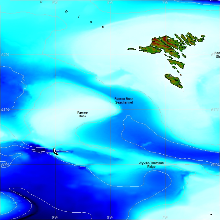
Map produced using the GEBCO Digital Atlas.
Nominal station details - Wyville Thomson Gully Section
| Station | Nominal latitude | Nominal longitude | Approx. depth (m) | Comment |
|---|---|---|---|---|
| Wyville Thomson Gully Station S350 official nominal position | 60° 17.664' N | 9° 0.9708' W | 567 | - |
| Wyville Thomson Gully Station S351 official nominal position | 60° 16.683' N | 9° 0.7722' W | 792 | |
| Wyville Thomson Gully Station S352 official nominal position | 60° 15.6732' N | 9° 0.5136' W | 1080 | |
| Wyville Thomson Gully Station S353 official nominal position | 60° 14.7036' N | 9° 0.2946' W | 1301 | |
| Wyville Thomson Gully Station S354 official nominal position | 60° 13.803' N | 8° 59.2614' W | 1015 | |
| Wyville Thomson Gully Station S355 official nominal position | 60° 12.4896' N | 8° 57.6744' W | 558 |
Related Fixed Station activities are detailed in Appendix 4
BODC Quality Control Flags
The following single character qualifying flags may be associated with one or more individual parameters with a data cycle:
| Flag | Description |
|---|---|
| Blank | Unqualified |
| < | Below detection limit |
| > | In excess of quoted value |
| A | Taxonomic flag for affinis (aff.) |
| B | Beginning of CTD Down/Up Cast |
| C | Taxonomic flag for confer (cf.) |
| D | Thermometric depth |
| E | End of CTD Down/Up Cast |
| G | Non-taxonomic biological characteristic uncertainty |
| H | Extrapolated value |
| I | Taxonomic flag for single species (sp.) |
| K | Improbable value - unknown quality control source |
| L | Improbable value - originator's quality control |
| M | Improbable value - BODC quality control |
| N | Null value |
| O | Improbable value - user quality control |
| P | Trace/calm |
| Q | Indeterminate |
| R | Replacement value |
| S | Estimated value |
| T | Interpolated value |
| U | Uncalibrated |
| W | Control value |
| X | Excessive difference |
SeaDataNet Quality Control Flags
The following single character qualifying flags may be associated with one or more individual parameters with a data cycle:
| Flag | Description |
|---|---|
| 0 | no quality control |
| 1 | good value |
| 2 | probably good value |
| 3 | probably bad value |
| 4 | bad value |
| 5 | changed value |
| 6 | value below detection |
| 7 | value in excess |
| 8 | interpolated value |
| 9 | missing value |
| A | value phenomenon uncertain |
| B | nominal value |
| Q | value below limit of quantification |
Appendix 1: JC086_CTD_C006
Related series for this Data Activity are presented in the table below. Further information can be found by following the appropriate links.
If you are interested in these series, please be aware we offer a multiple file download service. Should your credentials be insufficient for automatic download, the service also offers a referral to our Enquiries Officer who may be able to negotiate access.
| Series Identifier | Data Category | Start date/time | Start position | Cruise |
|---|---|---|---|---|
| 2101104 | Water sample data | 2013-05-08 19:07:00 | 60.43833 N, 9.2175 W | RRS James Cook JC086 |
Appendix 2: Wyville Thomson Ridge
Related series for this Fixed Station are presented in the table below. Further information can be found by following the appropriate links.
If you are interested in these series, please be aware we offer a multiple file download service. Should your credentials be insufficient for automatic download, the service also offers a referral to our Enquiries Officer who may be able to negotiate access.
| Series Identifier | Data Category | Start date/time | Start position | Cruise |
|---|---|---|---|---|
| 626899 | CTD or STD cast | 2003-04-20 03:13:00 | 59.9437 N, 8.1305 W | FRV Scotia 0703S |
| 626906 | CTD or STD cast | 2003-04-20 04:00:00 | 59.955 N, 8.1967 W | FRV Scotia 0703S |
| 626918 | CTD or STD cast | 2003-04-20 04:47:00 | 59.9663 N, 8.2597 W | FRV Scotia 0703S |
| 626931 | CTD or STD cast | 2003-04-20 05:32:00 | 59.9792 N, 8.3025 W | FRV Scotia 0703S |
| 626943 | CTD or STD cast | 2003-04-20 07:12:00 | 59.9972 N, 8.3603 W | FRV Scotia 0703S |
| 626955 | CTD or STD cast | 2003-04-20 08:24:00 | 59.9943 N, 8.376 W | FRV Scotia 0703S |
| 626967 | CTD or STD cast | 2003-04-20 09:36:00 | 60.001 N, 8.4297 W | FRV Scotia 0703S |
| 626979 | CTD or STD cast | 2003-04-20 10:43:00 | 60.0072 N, 8.4618 W | FRV Scotia 0703S |
| 626980 | CTD or STD cast | 2003-04-20 11:42:00 | 60.011 N, 8.4943 W | FRV Scotia 0703S |
| 626992 | CTD or STD cast | 2003-04-20 12:53:00 | 60.0182 N, 8.5375 W | FRV Scotia 0703S |
| 627006 | CTD or STD cast | 2003-04-20 13:43:00 | 60.0252 N, 8.5728 W | FRV Scotia 0703S |
| 627018 | CTD or STD cast | 2003-04-20 14:42:00 | 60.0407 N, 8.6428 W | FRV Scotia 0703S |
| 627031 | CTD or STD cast | 2003-04-20 15:35:00 | 60.0655 N, 8.5973 W | FRV Scotia 0703S |
| 627043 | CTD or STD cast | 2003-04-20 16:22:00 | 60.0853 N, 8.5553 W | FRV Scotia 0703S |
| 627055 | CTD or STD cast | 2003-04-20 17:12:00 | 60.106 N, 8.5227 W | FRV Scotia 0703S |
| 627067 | CTD or STD cast | 2003-04-20 18:05:00 | 60.118 N, 8.5005 W | FRV Scotia 0703S |
| 627079 | CTD or STD cast | 2003-04-20 19:01:00 | 60.1338 N, 8.4765 W | FRV Scotia 0703S |
| 627080 | CTD or STD cast | 2003-04-20 20:03:00 | 60.1508 N, 8.4478 W | FRV Scotia 0703S |
| 627092 | CTD or STD cast | 2003-04-20 21:09:00 | 60.162 N, 8.4237 W | FRV Scotia 0703S |
| 627111 | CTD or STD cast | 2003-04-20 22:38:00 | 60.1813 N, 8.4073 W | FRV Scotia 0703S |
| 627123 | CTD or STD cast | 2003-04-20 23:51:00 | 60.2005 N, 8.384 W | FRV Scotia 0703S |
| 627135 | CTD or STD cast | 2003-04-21 01:50:00 | 60.2177 N, 8.3677 W | FRV Scotia 0703S |
| 627147 | CTD or STD cast | 2003-04-21 02:12:00 | 60.24 N, 8.3435 W | FRV Scotia 0703S |
| 627159 | CTD or STD cast | 2003-04-21 03:19:00 | 60.2483 N, 8.3317 W | FRV Scotia 0703S |
| 627160 | CTD or STD cast | 2003-04-21 04:25:00 | 60.2598 N, 8.3207 W | FRV Scotia 0703S |
| 627172 | CTD or STD cast | 2003-04-21 05:31:00 | 60.278 N, 8.3028 W | FRV Scotia 0703S |
| 627184 | CTD or STD cast | 2003-04-21 06:25:00 | 60.294 N, 8.2863 W | FRV Scotia 0703S |
| 627196 | CTD or STD cast | 2003-04-21 07:31:00 | 60.315 N, 8.2677 W | FRV Scotia 0703S |
| 627203 | CTD or STD cast | 2003-04-21 09:03:00 | 60.355 N, 8.2293 W | FRV Scotia 0703S |
| 627215 | CTD or STD cast | 2003-04-21 12:37:00 | 60.3955 N, 9.1597 W | FRV Scotia 0703S |
| 627227 | CTD or STD cast | 2003-04-21 13:34:00 | 60.3458 N, 9.1788 W | FRV Scotia 0703S |
| 627239 | CTD or STD cast | 2003-04-21 14:27:00 | 60.3262 N, 9.1877 W | FRV Scotia 0703S |
| 627240 | CTD or STD cast | 2003-04-21 15:30:00 | 60.3102 N, 9.1952 W | FRV Scotia 0703S |
| 627252 | CTD or STD cast | 2003-04-21 16:44:00 | 60.2928 N, 9.205 W | FRV Scotia 0703S |
| 627264 | CTD or STD cast | 2003-04-21 18:33:00 | 60.2698 N, 9.2032 W | FRV Scotia 0703S |
| 627276 | CTD or STD cast | 2003-04-21 20:19:00 | 60.2537 N, 9.2555 W | FRV Scotia 0703S |
| 627288 | CTD or STD cast | 2003-04-21 22:18:00 | 60.2255 N, 9.3653 W | FRV Scotia 0703S |
| 627307 | CTD or STD cast | 2003-04-22 00:26:00 | 60.2002 N, 9.4585 W | FRV Scotia 0703S |
| 627319 | CTD or STD cast | 2003-04-22 02:23:00 | 60.1778 N, 9.5617 W | FRV Scotia 0703S |
| 627320 | CTD or STD cast | 2003-04-22 04:06:00 | 60.1458 N, 9.6712 W | FRV Scotia 0703S |
| 627332 | CTD or STD cast | 2003-04-22 05:44:00 | 60.1642 N, 9.8153 W | FRV Scotia 0703S |
| 627344 | CTD or STD cast | 2003-04-22 07:10:00 | 60.2138 N, 9.8157 W | FRV Scotia 0703S |
| 627356 | CTD or STD cast | 2003-04-22 08:34:00 | 60.2682 N, 9.8153 W | FRV Scotia 0703S |
| 627368 | CTD or STD cast | 2003-04-22 09:53:00 | 60.321 N, 9.8142 W | FRV Scotia 0703S |
| 627381 | CTD or STD cast | 2003-04-22 11:16:00 | 60.352 N, 9.8158 W | FRV Scotia 0703S |
| 627393 | CTD or STD cast | 2003-04-22 12:31:00 | 60.375 N, 9.8165 W | FRV Scotia 0703S |
| 627400 | CTD or STD cast | 2003-04-22 13:51:00 | 60.4305 N, 9.814 W | FRV Scotia 0703S |
| 627412 | CTD or STD cast | 2003-04-22 14:48:00 | 60.447 N, 9.817 W | FRV Scotia 0703S |
| 627424 | CTD or STD cast | 2003-04-22 19:35:00 | 60.4005 N, 8.5665 W | FRV Scotia 0703S |
| 627436 | CTD or STD cast | 2003-04-22 20:45:00 | 60.3623 N, 8.4053 W | FRV Scotia 0703S |
| 627448 | CTD or STD cast | 2003-04-22 22:02:00 | 60.3165 N, 8.2693 W | FRV Scotia 0703S |
| 627461 | CTD or STD cast | 2003-04-22 23:22:00 | 60.2787 N, 8.1137 W | FRV Scotia 0703S |
| 627473 | CTD or STD cast | 2003-04-23 00:35:00 | 60.2423 N, 7.954 W | FRV Scotia 0703S |
| 627485 | CTD or STD cast | 2003-04-23 01:45:00 | 60.203 N, 7.815 W | FRV Scotia 0703S |
| 627497 | CTD or STD cast | 2003-04-23 02:47:00 | 60.1907 N, 7.7233 W | FRV Scotia 0703S |
| 627504 | CTD or STD cast | 2003-04-23 03:52:00 | 60.1787 N, 7.6223 W | FRV Scotia 0703S |
| 627516 | CTD or STD cast | 2003-04-23 05:10:00 | 60.1357 N, 7.4828 W | FRV Scotia 0703S |
| 627528 | CTD or STD cast | 2003-04-23 06:25:00 | 60.0737 N, 7.3432 W | FRV Scotia 0703S |
| 627541 | CTD or STD cast | 2003-04-23 07:37:00 | 60.0397 N, 7.1873 W | FRV Scotia 0703S |
| 627553 | CTD or STD cast | 2003-04-23 08:56:00 | 60.0032 N, 6.9805 W | FRV Scotia 0703S |
| 627565 | CTD or STD cast | 2003-04-23 09:48:00 | 59.9945 N, 6.8983 W | FRV Scotia 0703S |
| 627577 | CTD or STD cast | 2003-04-23 10:52:00 | 59.9922 N, 6.7567 W | FRV Scotia 0703S |
| 627589 | CTD or STD cast | 2003-04-23 12:04:00 | 59.9608 N, 6.5878 W | FRV Scotia 0703S |
| 627590 | CTD or STD cast | 2003-04-23 13:08:00 | 59.9173 N, 6.438 W | FRV Scotia 0703S |
| 627608 | CTD or STD cast | 2003-04-23 14:06:00 | 59.8697 N, 6.3035 W | FRV Scotia 0703S |
| 627621 | CTD or STD cast | 2003-04-23 15:08:00 | 59.8132 N, 6.2093 W | FRV Scotia 0703S |
| 627633 | CTD or STD cast | 2003-04-23 16:05:00 | 59.7498 N, 6.1825 W | FRV Scotia 0703S |
| 627645 | CTD or STD cast | 2003-04-25 18:19:00 | 60.0425 N, 6.5553 W | FRV Scotia 0703S |
| 627657 | CTD or STD cast | 2003-04-25 19:25:00 | 60.049 N, 6.6513 W | FRV Scotia 0703S |
| 627669 | CTD or STD cast | 2003-04-25 20:33:00 | 60.0512 N, 6.7603 W | FRV Scotia 0703S |
| 627670 | CTD or STD cast | 2003-04-25 21:48:00 | 60.044 N, 6.87 W | FRV Scotia 0703S |
| 627682 | CTD or STD cast | 2003-04-25 23:07:00 | 60.076 N, 6.9695 W | FRV Scotia 0703S |
| 627694 | CTD or STD cast | 2003-04-26 00:23:00 | 60.0898 N, 7.0712 W | FRV Scotia 0703S |
| 627701 | CTD or STD cast | 2003-04-26 01:35:00 | 60.1097 N, 7.1728 W | FRV Scotia 0703S |
| 627713 | CTD or STD cast | 2003-04-26 02:50:00 | 60.1325 N, 7.2478 W | FRV Scotia 0703S |
| 627725 | CTD or STD cast | 2003-04-26 04:10:00 | 60.152 N, 7.3427 W | FRV Scotia 0703S |
| 627737 | CTD or STD cast | 2003-04-26 05:43:00 | 60.1725 N, 7.4442 W | FRV Scotia 0703S |
| 627749 | CTD or STD cast | 2003-04-26 06:45:00 | 60.1993 N, 7.513 W | FRV Scotia 0703S |
| 627750 | CTD or STD cast | 2003-04-26 07:50:00 | 60.2232 N, 7.6033 W | FRV Scotia 0703S |
| 627762 | CTD or STD cast | 2003-04-26 12:44:00 | 60.4238 N, 9.2537 W | FRV Scotia 0703S |
| 627774 | CTD or STD cast | 2003-04-26 13:17:00 | 60.4063 N, 9.3028 W | FRV Scotia 0703S |
| 627786 | CTD or STD cast | 2003-04-26 13:52:00 | 60.3992 N, 9.3275 W | FRV Scotia 0703S |
| 627798 | CTD or STD cast | 2003-04-26 14:35:00 | 60.3898 N, 9.3512 W | FRV Scotia 0703S |
| 627805 | CTD or STD cast | 2003-04-26 15:39:00 | 60.3755 N, 9.3962 W | FRV Scotia 0703S |
| 627817 | CTD or STD cast | 2003-04-26 16:51:00 | 60.3558 N, 9.447 W | FRV Scotia 0703S |
| 627829 | CTD or STD cast | 2003-04-26 18:16:00 | 60.3848 N, 9.573 W | FRV Scotia 0703S |
| 627830 | CTD or STD cast | 2003-04-26 19:27:00 | 60.3998 N, 9.6482 W | FRV Scotia 0703S |
| 627842 | CTD or STD cast | 2003-04-26 20:29:00 | 60.4075 N, 9.6843 W | FRV Scotia 0703S |
| 627854 | CTD or STD cast | 2003-04-26 21:30:00 | 60.415 N, 9.7168 W | FRV Scotia 0703S |
| 627866 | CTD or STD cast | 2003-04-26 22:31:00 | 60.4253 N, 9.7618 W | FRV Scotia 0703S |
| 627878 | CTD or STD cast | 2003-04-26 23:29:00 | 60.454 N, 9.764 W | FRV Scotia 0703S |
| 627891 | CTD or STD cast | 2003-04-27 00:16:00 | 60.457 N, 9.6963 W | FRV Scotia 0703S |
| 627909 | CTD or STD cast | 2003-04-27 01:11:00 | 60.4598 N, 9.6118 W | FRV Scotia 0703S |
| 627910 | CTD or STD cast | 2003-04-27 03:13:00 | 60.4667 N, 9.5283 W | FRV Scotia 0703S |
| 627922 | CTD or STD cast | 2003-04-27 03:53:00 | 60.4702 N, 9.4908 W | FRV Scotia 0703S |
| 627934 | CTD or STD cast | 2003-04-27 04:37:00 | 60.4723 N, 9.4308 W | FRV Scotia 0703S |
| 627946 | CTD or STD cast | 2003-04-27 05:30:00 | 60.482 N, 9.2873 W | FRV Scotia 0703S |
| 627958 | CTD or STD cast | 2003-04-27 06:48:00 | 60.4942 N, 9.0017 W | FRV Scotia 0703S |
| 627971 | CTD or STD cast | 2003-04-27 07:50:00 | 60.4307 N, 8.8362 W | FRV Scotia 0703S |
| 627983 | CTD or STD cast | 2003-04-27 08:39:00 | 60.3682 N, 8.8527 W | FRV Scotia 0703S |
| 627995 | CTD or STD cast | 2003-04-27 09:18:00 | 60.3363 N, 8.8638 W | FRV Scotia 0703S |
| 628009 | CTD or STD cast | 2003-04-27 10:05:00 | 60.3005 N, 8.8818 W | FRV Scotia 0703S |
| 628010 | CTD or STD cast | 2003-04-27 11:11:00 | 60.267 N, 8.8903 W | FRV Scotia 0703S |
| 628022 | CTD or STD cast | 2003-04-27 12:05:00 | 60.2442 N, 8.9063 W | FRV Scotia 0703S |
| 628034 | CTD or STD cast | 2003-04-27 13:22:00 | 60.224 N, 8.9128 W | FRV Scotia 0703S |
| 628046 | CTD or STD cast | 2003-04-27 14:11:00 | 60.2093 N, 8.9155 W | FRV Scotia 0703S |
| 628058 | CTD or STD cast | 2003-04-27 15:02:00 | 60.179 N, 8.9295 W | FRV Scotia 0703S |
| 628071 | CTD or STD cast | 2003-04-27 16:28:00 | 60.2712 N, 9.2132 W | FRV Scotia 0703S |
| 628083 | CTD or STD cast | 2003-04-27 17:52:00 | 60.282 N, 9.1667 W | FRV Scotia 0703S |
| 628095 | CTD or STD cast | 2003-04-27 19:28:00 | 60.292 N, 9.1312 W | FRV Scotia 0703S |
| 628102 | CTD or STD cast | 2003-04-27 20:31:00 | 60.2993 N, 9.0868 W | FRV Scotia 0703S |
| 628114 | CTD or STD cast | 2003-04-27 21:23:00 | 60.3128 N, 9.0282 W | FRV Scotia 0703S |
| 628126 | CTD or STD cast | 2003-04-27 22:48:00 | 60.2952 N, 9.018 W | FRV Scotia 0703S |
| 628138 | CTD or STD cast | 2003-04-27 23:32:00 | 60.2785 N, 9.0142 W | FRV Scotia 0703S |
| 628151 | CTD or STD cast | 2003-04-28 00:23:00 | 60.2622 N, 9.01 W | FRV Scotia 0703S |
| 628163 | CTD or STD cast | 2003-04-28 01:25:00 | 60.2495 N, 9.0072 W | FRV Scotia 0703S |
| 628175 | CTD or STD cast | 2003-04-28 02:38:00 | 60.2302 N, 8.9903 W | FRV Scotia 0703S |
| 628187 | CTD or STD cast | 2003-04-28 03:45:00 | 60.2085 N, 8.9617 W | FRV Scotia 0703S |
| 628199 | CTD or STD cast | 2003-04-28 04:52:00 | 60.148 N, 8.8472 W | FRV Scotia 0703S |
| 628206 | CTD or STD cast | 2003-04-28 05:37:00 | 60.1795 N, 8.763 W | FRV Scotia 0703S |
| 628218 | CTD or STD cast | 2003-04-28 06:26:00 | 60.1982 N, 8.6935 W | FRV Scotia 0703S |
| 628231 | CTD or STD cast | 2003-04-28 07:23:00 | 60.223 N, 8.6103 W | FRV Scotia 0703S |
| 628243 | CTD or STD cast | 2003-04-28 08:18:00 | 60.264 N, 8.5852 W | FRV Scotia 0703S |
| 628255 | CTD or STD cast | 2003-04-28 09:16:00 | 60.3072 N, 8.5597 W | FRV Scotia 0703S |
| 628267 | CTD or STD cast | 2003-04-28 10:05:00 | 60.3422 N, 8.5412 W | FRV Scotia 0703S |
| 628279 | CTD or STD cast | 2003-04-28 10:53:00 | 60.3888 N, 8.5135 W | FRV Scotia 0703S |
| 628280 | CTD or STD cast | 2003-04-28 14:35:00 | 60.1753 N, 9.5588 W | FRV Scotia 0703S |
| 628292 | CTD or STD cast | 2003-04-28 15:40:00 | 60.1757 N, 9.4652 W | FRV Scotia 0703S |
| 628311 | CTD or STD cast | 2003-04-28 16:49:00 | 60.1782 N, 9.375 W | FRV Scotia 0703S |
| 628323 | CTD or STD cast | 2003-04-28 18:09:00 | 60.1783 N, 9.2328 W | FRV Scotia 0703S |
| 628335 | CTD or STD cast | 2003-04-28 19:34:00 | 60.1775 N, 9.0308 W | FRV Scotia 0703S |
| 628347 | CTD or STD cast | 2003-04-28 21:55:00 | 60.1493 N, 8.452 W | FRV Scotia 0703S |
| 845261 | CTD or STD cast | 2003-07-27 18:51:00 | 59.71597 N, 7.15278 W | Poseidon PO300_2 |
| 845273 | CTD or STD cast | 2003-07-28 20:39:00 | 59.8202 N, 6.95063 W | Poseidon PO300_2 |
| 845285 | CTD or STD cast | 2003-07-28 22:15:00 | 59.86838 N, 6.83345 W | Poseidon PO300_2 |
| 845297 | CTD or STD cast | 2003-07-29 00:00:00 | 59.91805 N, 6.7241 W | Poseidon PO300_2 |
| 845304 | CTD or STD cast | 2003-07-29 01:29:00 | 59.96848 N, 6.61855 W | Poseidon PO300_2 |
| 845316 | CTD or STD cast | 2003-07-29 02:52:00 | 60.01832 N, 6.5087 W | Poseidon PO300_2 |
| 845328 | CTD or STD cast | 2003-07-29 20:02:00 | 60.168 N, 6.16677 W | Poseidon PO300_2 |
| 845341 | CTD or STD cast | 2003-07-29 22:13:00 | 60.11595 N, 6.27883 W | Poseidon PO300_2 |
| 845353 | CTD or STD cast | 2003-07-30 00:03:00 | 60.06682 N, 6.39653 W | Poseidon PO300_2 |
| 845365 | CTD or STD cast | 2003-07-30 01:24:00 | 60.0279 N, 6.48653 W | Poseidon PO300_2 |
| 845377 | CTD or STD cast | 2003-07-30 02:49:00 | 60.05145 N, 6.63285 W | Poseidon PO300_2 |
| 845389 | CTD or STD cast | 2003-07-30 09:46:00 | 60.10163 N, 6.09385 W | Poseidon PO300_2 |
| 845390 | CTD or STD cast | 2003-07-30 16:22:00 | 60.0508 N, 6.81967 W | Poseidon PO300_2 |
| 845408 | CTD or STD cast | 2003-07-30 17:41:00 | 60.08522 N, 6.93385 W | Poseidon PO300_2 |
| 845421 | CTD or STD cast | 2003-07-30 19:03:00 | 60.11207 N, 7.06995 W | Poseidon PO300_2 |
| 845433 | CTD or STD cast | 2003-07-30 20:52:00 | 60.14212 N, 7.23043 W | Poseidon PO300_2 |
| 845445 | CTD or STD cast | 2003-07-30 22:24:00 | 60.1744 N, 7.38717 W | Poseidon PO300_2 |
| 845457 | CTD or STD cast | 2003-07-30 23:43:00 | 60.20735 N, 7.53108 W | Poseidon PO300_2 |
| 845469 | CTD or STD cast | 2003-07-31 00:56:00 | 60.2355 N, 7.6598 W | Poseidon PO300_2 |
| 845470 | CTD or STD cast | 2003-07-31 02:13:00 | 60.26925 N, 7.80108 W | Poseidon PO300_2 |
| 845482 | CTD or STD cast | 2003-07-31 03:32:00 | 60.2949 N, 7.9169 W | Poseidon PO300_2 |
| 845494 | CTD or STD cast | 2003-08-01 05:17:00 | 60.1811 N, 7.73665 W | Poseidon PO300_2 |
| 1014447 | Currents -subsurface Eulerian | 2003-08-01 09:30:00 | 60.183 N, 7.7338 W | Poseidon PO300_2 |
| 1014435 | Currents -subsurface Eulerian | 2003-09-28 19:30:00 | 60.23917 N, 8.86833 W | FRV Scotia 1403S |
| 896598 | CTD or STD cast | 2005-10-14 09:31:00 | 60.2159 N, 6.19836 W | RRS Charles Darwin CD176 |
| 896605 | CTD or STD cast | 2005-10-14 11:20:00 | 60.21326 N, 6.20296 W | RRS Charles Darwin CD176 |
| 896617 | CTD or STD cast | 2005-10-14 13:53:00 | 60.29942 N, 6.11356 W | RRS Charles Darwin CD176 |
| 896629 | CTD or STD cast | 2005-10-14 23:59:00 | 60.08054 N, 6.32135 W | RRS Charles Darwin CD176 |
| 896630 | CTD or STD cast | 2005-10-15 02:04:00 | 60.0144 N, 6.34818 W | RRS Charles Darwin CD176 |
| 896642 | CTD or STD cast | 2005-10-15 23:45:00 | 60.33948 N, 9.0409 W | RRS Charles Darwin CD176 |
| 896654 | CTD or STD cast | 2005-10-16 01:45:00 | 60.28932 N, 9.02996 W | RRS Charles Darwin CD176 |
| 896666 | CTD or STD cast | 2005-10-16 03:38:00 | 60.27818 N, 9.01476 W | RRS Charles Darwin CD176 |
| 896678 | CTD or STD cast | 2005-10-16 05:30:00 | 60.26256 N, 9.0105 W | RRS Charles Darwin CD176 |
| 896691 | CTD or STD cast | 2005-10-16 07:55:00 | 60.24946 N, 9.00726 W | RRS Charles Darwin CD176 |
| 896709 | CTD or STD cast | 2005-10-16 10:51:00 | 60.22923 N, 8.99213 W | RRS Charles Darwin CD176 |
| 896710 | CTD or STD cast | 2005-10-16 12:46:00 | 60.18908 N, 8.96128 W | RRS Charles Darwin CD176 |
| 1014459 | Currents -subsurface Eulerian | 2005-10-16 15:30:00 | 60.23942 N, 8.86997 W | RRS Charles Darwin CD176 |
| 896722 | CTD or STD cast | 2005-10-16 21:16:00 | 60.4263 N, 8.24386 W | RRS Charles Darwin CD176 |
| 1014460 | Currents -subsurface Eulerian | 2006-05-07 08:02:41 | 60.2495 N, 8.91 W | FRV Scotia 0706S |
| 776793 | CTD or STD cast | 2006-10-28 04:24:44 | 60.34267 N, 8.99217 W | RRS Discovery D312 |
| 776800 | CTD or STD cast | 2006-10-28 05:48:17 | 60.3115 N, 8.94867 W | RRS Discovery D312 |
| 776812 | CTD or STD cast | 2006-10-28 07:45:53 | 60.298 N, 8.932 W | RRS Discovery D312 |
| 776824 | CTD or STD cast | 2006-10-28 09:33:32 | 60.26583 N, 8.91833 W | RRS Discovery D312 |
| 776836 | CTD or STD cast | 2006-10-28 12:38:43 | 60.284 N, 8.92417 W | RRS Discovery D312 |
| 776848 | CTD or STD cast | 2006-10-28 14:06:35 | 60.255 N, 8.91567 W | RRS Discovery D312 |
| 1014472 | Currents -subsurface Eulerian | 2006-10-28 16:33:08 | 60.25 N, 8.9165 W | RRS Discovery D312 |
| 776861 | CTD or STD cast | 2006-10-28 16:54:10 | 60.2365 N, 8.91617 W | RRS Discovery D312 |
| 776873 | CTD or STD cast | 2006-10-28 19:32:14 | 60.22717 N, 8.917 W | RRS Discovery D312 |
| 847673 | CTD or STD cast | 2007-09-02 15:12:51 | 60.24698 N, 9.00905 W | RRS Discovery D321B |
| 1014484 | Currents -subsurface Eulerian | 2007-09-02 17:45:00 | 60.24517 N, 9.01267 W | RRS Discovery D321B |
| 847685 | CTD or STD cast | 2007-09-02 22:31:15 | 60.54961 N, 8.1944 W | RRS Discovery D321B |
| 847697 | CTD or STD cast | 2007-09-03 03:34:58 | 60.59987 N, 8.28802 W | RRS Discovery D321B |
| 847704 | CTD or STD cast | 2007-09-03 04:13:23 | 60.60423 N, 8.28849 W | RRS Discovery D321B |
| 847901 | CTD or STD cast | 2007-09-04 08:08:33 | 60.59981 N, 8.1302 W | RRS Discovery D321B |
| 847716 | CTD or STD cast | 2007-09-04 17:39:37 | 60.57216 N, 7.48264 W | RRS Discovery D321B |
| 847728 | CTD or STD cast | 2007-09-05 00:40:48 | 60.3882 N, 7.25541 W | RRS Discovery D321B |
| 847741 | CTD or STD cast | 2007-09-05 08:32:53 | 60.26364 N, 6.84096 W | RRS Discovery D321B |
| 847753 | CTD or STD cast | 2007-09-07 01:58:25 | 60.16545 N, 6.16475 W | RRS Discovery D321B |
| 847765 | CTD or STD cast | 2007-09-07 04:20:22 | 60.11849 N, 6.27459 W | RRS Discovery D321B |
| 847777 | CTD or STD cast | 2007-09-07 06:23:34 | 60.06818 N, 6.38362 W | RRS Discovery D321B |
| 847789 | CTD or STD cast | 2007-09-07 08:13:00 | 60.0348 N, 6.41938 W | RRS Discovery D321B |
| 847790 | CTD or STD cast | 2007-09-07 11:03:00 | 60.01627 N, 6.50561 W | RRS Discovery D321B |
| 847808 | CTD or STD cast | 2007-09-07 12:27:38 | 59.96778 N, 6.62012 W | RRS Discovery D321B |
| 847821 | CTD or STD cast | 2007-09-07 13:46:35 | 59.91902 N, 6.73161 W | RRS Discovery D321B |
| 847833 | CTD or STD cast | 2007-09-07 15:43:43 | 59.8233 N, 6.95149 W | RRS Discovery D321B |
| 1623433 | Currents -subsurface Eulerian | 2008-05-18 20:55:00 | 60.24517 N, 9.01267 W | FRV Scotia 0508S |
| 1623445 | Currents -subsurface Eulerian | 2008-06-18 00:10:00 | 60.24517 N, 9.01267 W | FRV Scotia 0508S |
| 1623457 | Currents -subsurface Eulerian | 2008-07-18 00:10:00 | 60.24517 N, 9.01267 W | FRV Scotia 0508S |
| 1623469 | Currents -subsurface Eulerian | 2008-08-18 00:10:00 | 60.24517 N, 9.01267 W | FRV Scotia 0508S |
| 1623470 | Currents -subsurface Eulerian | 2008-09-18 00:10:00 | 60.24517 N, 9.01267 W | FRV Scotia 0508S |
| 1623482 | Currents -subsurface Eulerian | 2008-10-18 00:10:00 | 60.24517 N, 9.01267 W | FRV Scotia 0508S |
| 1623494 | Currents -subsurface Eulerian | 2008-11-18 00:10:00 | 60.24517 N, 9.01267 W | FRV Scotia 0508S |
| 1623501 | Currents -subsurface Eulerian | 2008-12-18 00:10:00 | 60.24517 N, 9.01267 W | FRV Scotia 0508S |
| 1623513 | Currents -subsurface Eulerian | 2009-01-18 00:10:00 | 60.24517 N, 9.01267 W | FRV Scotia 0508S |
| 1623525 | Currents -subsurface Eulerian | 2009-02-18 00:10:00 | 60.24517 N, 9.01267 W | FRV Scotia 0508S |
| 1623537 | Currents -subsurface Eulerian | 2009-03-18 00:10:00 | 60.24517 N, 9.01267 W | FRV Scotia 0508S |
| 1623549 | Currents -subsurface Eulerian | 2009-04-18 00:10:00 | 60.24517 N, 9.01267 W | FRV Scotia 0508S |
| 1623550 | Currents -subsurface Eulerian | 2009-05-18 00:10:00 | 60.24517 N, 9.01267 W | FRV Scotia 0508S |
| 954401 | CTD or STD cast | 2009-06-21 16:07:50 | 60.20665 N, 8.95695 W | RRS Discovery D340A |
| 954413 | CTD or STD cast | 2009-06-21 17:20:27 | 60.2186 N, 8.97383 W | RRS Discovery D340A |
| 954425 | CTD or STD cast | 2009-06-21 18:21:56 | 60.22989 N, 8.99 W | RRS Discovery D340A |
| 954437 | CTD or STD cast | 2009-06-21 19:58:18 | 60.24991 N, 9.00529 W | RRS Discovery D340A |
| 954449 | CTD or STD cast | 2009-06-21 21:11:56 | 60.26127 N, 9.00824 W | RRS Discovery D340A |
| 954450 | CTD or STD cast | 2009-06-21 22:24:23 | 60.2783 N, 9.01223 W | RRS Discovery D340A |
| 954462 | CTD or STD cast | 2009-06-22 00:03:16 | 60.29325 N, 9.01763 W | RRS Discovery D340A |
| 954474 | CTD or STD cast | 2009-06-22 01:20:57 | 60.33382 N, 9.02786 W | RRS Discovery D340A |
| 954486 | CTD or STD cast | 2009-06-22 03:05:44 | 60.38812 N, 9.03649 W | RRS Discovery D340A |
| 954498 | CTD or STD cast | 2009-06-22 04:49:33 | 60.26206 N, 9.00946 W | RRS Discovery D340A |
| 954505 | CTD or STD cast | 2009-06-22 07:35:09 | 60.23988 N, 8.99759 W | RRS Discovery D340A |
| 954517 | CTD or STD cast | 2009-06-22 10:33:56 | 60.29171 N, 9.12969 W | RRS Discovery D340A |
| 954529 | CTD or STD cast | 2009-06-22 11:52:23 | 60.26806 N, 9.20608 W | RRS Discovery D340A |
| 954530 | CTD or STD cast | 2009-06-22 14:20:10 | 60.24754 N, 9.28554 W | RRS Discovery D340A |
| 954542 | CTD or STD cast | 2009-06-22 16:21:18 | 60.22707 N, 9.36207 W | RRS Discovery D340A |
| 954554 | CTD or STD cast | 2009-06-22 18:09:24 | 60.19218 N, 9.49349 W | RRS Discovery D340A |
| 954566 | CTD or STD cast | 2009-06-22 20:32:12 | 60.35444 N, 9.44191 W | RRS Discovery D340A |
| 954578 | CTD or STD cast | 2009-06-22 22:40:14 | 60.31848 N, 9.35247 W | RRS Discovery D340A |
| 954591 | CTD or STD cast | 2009-06-23 00:28:59 | 60.29054 N, 9.27921 W | RRS Discovery D340A |
| 954609 | CTD or STD cast | 2009-06-23 02:46:20 | 60.25009 N, 9.15898 W | RRS Discovery D340A |
| 954610 | CTD or STD cast | 2009-06-23 04:30:26 | 60.22413 N, 9.07486 W | RRS Discovery D340A |
| 954622 | CTD or STD cast | 2009-06-23 07:27:28 | 60.25882 N, 9.12326 W | RRS Discovery D340A |
| 954634 | CTD or STD cast | 2009-06-23 09:32:52 | 60.24685 N, 9.06133 W | RRS Discovery D340A |
| 954646 | CTD or STD cast | 2009-06-23 11:27:59 | 60.24213 N, 8.91099 W | RRS Discovery D340A |
| 954658 | CTD or STD cast | 2009-06-23 13:21:42 | 60.24256 N, 8.81257 W | RRS Discovery D340A |
| 954671 | CTD or STD cast | 2009-06-23 15:41:22 | 60.24605 N, 9.0164 W | RRS Discovery D340A |
| 1639619 | Currents -subsurface Eulerian | 2011-05-12 08:30:00 | 60.2475 N, 8.92166 W | FRV Scotia 0511S |
| 1639620 | Currents -subsurface Eulerian | 2011-06-12 00:00:00 | 60.2475 N, 8.92166 W | FRV Scotia 0511S |
| 1639632 | Currents -subsurface Eulerian | 2011-07-12 00:00:00 | 60.2475 N, 8.92166 W | FRV Scotia 0511S |
| 1639644 | Currents -subsurface Eulerian | 2011-08-12 00:00:00 | 60.2475 N, 8.92166 W | FRV Scotia 0511S |
| 1639656 | Currents -subsurface Eulerian | 2011-09-12 00:00:00 | 60.2475 N, 8.92166 W | FRV Scotia 0511S |
| 1639668 | Currents -subsurface Eulerian | 2011-10-12 00:00:00 | 60.2475 N, 8.92166 W | FRV Scotia 0511S |
| 1639681 | Currents -subsurface Eulerian | 2011-11-12 00:00:00 | 60.2475 N, 8.92166 W | FRV Scotia 0511S |
| 1639693 | Currents -subsurface Eulerian | 2011-12-12 00:00:00 | 60.2475 N, 8.92166 W | FRV Scotia 0511S |
| 1639700 | Currents -subsurface Eulerian | 2012-01-12 00:14:59 | 60.2475 N, 8.92166 W | FRV Scotia 0511S |
| 1639712 | Currents -subsurface Eulerian | 2012-02-12 00:14:59 | 60.2475 N, 8.92166 W | FRV Scotia 0511S |
| 1639724 | Currents -subsurface Eulerian | 2012-03-12 00:14:59 | 60.2475 N, 8.92166 W | FRV Scotia 0511S |
| 1639736 | Currents -subsurface Eulerian | 2012-04-12 00:14:59 | 60.2475 N, 8.92166 W | FRV Scotia 0511S |
| 1639748 | Currents -subsurface Eulerian | 2012-05-12 00:14:59 | 60.2475 N, 8.92166 W | FRV Scotia 0511S |
| 1203661 | CTD or STD cast | 2012-08-06 18:18:00 | 60.38833 N, 8.51243 W | RRS Discovery D379 |
| 1203673 | CTD or STD cast | 2012-08-06 19:59:00 | 60.34098 N, 8.53872 W | RRS Discovery D379 |
| 1203685 | CTD or STD cast | 2012-08-06 21:42:00 | 60.308 N, 8.55094 W | RRS Discovery D379 |
| 1203697 | CTD or STD cast | 2012-08-06 23:36:00 | 60.26418 N, 8.57292 W | RRS Discovery D379 |
| 1203704 | CTD or STD cast | 2012-08-07 01:02:00 | 60.21951 N, 8.60904 W | RRS Discovery D379 |
| 1203716 | CTD or STD cast | 2012-08-07 03:03:00 | 60.19408 N, 8.69338 W | RRS Discovery D379 |
| 1203728 | CTD or STD cast | 2012-08-07 04:39:00 | 60.17799 N, 8.762 W | RRS Discovery D379 |
| 1203741 | CTD or STD cast | 2012-08-07 06:05:00 | 60.14615 N, 8.84574 W | RRS Discovery D379 |
| 1203753 | CTD or STD cast | 2012-08-07 07:43:00 | 60.20816 N, 8.96124 W | RRS Discovery D379 |
| 1203765 | CTD or STD cast | 2012-08-07 09:21:00 | 60.25059 N, 8.90955 W | RRS Discovery D379 |
| 1203777 | CTD or STD cast | 2012-08-07 12:28:00 | 60.23005 N, 8.98769 W | RRS Discovery D379 |
| 1203789 | CTD or STD cast | 2012-08-07 14:08:00 | 60.24506 N, 9.00491 W | RRS Discovery D379 |
| 1639515 | Currents -subsurface Eulerian | 2012-08-07 17:00:00 | 60.24996 N, 8.90965 W | RRS Discovery D379 |
| 1203790 | CTD or STD cast | 2012-08-07 17:35:00 | 60.26122 N, 9.00856 W | RRS Discovery D379 |
| 1640669 | Hydrography time series at depth | 2012-08-07 18:14:58 | 60.24996 N, 8.90965 W | RRS Discovery D379 |
| 1203808 | CTD or STD cast | 2012-08-07 19:24:00 | 60.27805 N, 9.01287 W | RRS Discovery D379 |
| 1203821 | CTD or STD cast | 2012-08-07 20:47:00 | 60.2944 N, 9.01618 W | RRS Discovery D379 |
| 1203833 | CTD or STD cast | 2012-08-07 22:06:00 | 60.31188 N, 9.02541 W | RRS Discovery D379 |
| 1639527 | Currents -subsurface Eulerian | 2012-09-07 00:14:59 | 60.24996 N, 8.90965 W | RRS Discovery D379 |
| 1639539 | Currents -subsurface Eulerian | 2012-10-07 00:14:59 | 60.24996 N, 8.90965 W | RRS Discovery D379 |
| 1639540 | Currents -subsurface Eulerian | 2012-11-07 00:14:59 | 60.24996 N, 8.90965 W | RRS Discovery D379 |
| 1639552 | Currents -subsurface Eulerian | 2012-12-07 00:14:59 | 60.24996 N, 8.90965 W | RRS Discovery D379 |
| 1639564 | Currents -subsurface Eulerian | 2013-01-07 00:14:59 | 60.24996 N, 8.90965 W | RRS Discovery D379 |
| 1639576 | Currents -subsurface Eulerian | 2013-02-07 00:14:59 | 60.24996 N, 8.90965 W | RRS Discovery D379 |
| 1639588 | Currents -subsurface Eulerian | 2013-03-07 00:14:59 | 60.24996 N, 8.90965 W | RRS Discovery D379 |
| 1639607 | Currents -subsurface Eulerian | 2013-04-07 00:14:59 | 60.24996 N, 8.90965 W | RRS Discovery D379 |
| 1219964 | CTD or STD cast | 2013-05-08 10:50:00 | 60.2078 N, 8.9611 W | RRS James Cook JC086 |
| 1219976 | CTD or STD cast | 2013-05-08 12:27:08 | 60.23 N, 8.99 W | RRS James Cook JC086 |
| 2101073 | Water sample data | 2013-05-08 13:06:30 | 60.4375 N, 9.09222 W | RRS James Cook JC086 |
| 1219988 | CTD or STD cast | 2013-05-08 14:45:52 | 60.2558 N, 9.0073 W | RRS James Cook JC086 |
| 2101085 | Water sample data | 2013-05-08 15:17:30 | 60.34611 N, 9.12111 W | RRS James Cook JC086 |
| 2101687 | Water sample data | 2013-05-08 15:17:30 | 60.34611 N, 9.12111 W | RRS James Cook JC086 |
| 1220001 | CTD or STD cast | 2013-05-08 16:38:43 | 60.2611 N, 9.008 W | RRS James Cook JC086 |
| 2101097 | Water sample data | 2013-05-08 17:15:00 | 60.435 N, 9.13389 W | RRS James Cook JC086 |
| 2101699 | Water sample data | 2013-05-08 17:15:00 | 60.435 N, 9.13389 W | RRS James Cook JC086 |
| 1220013 | CTD or STD cast | 2013-05-08 18:38:04 | 60.277 N, 9.0131 W | RRS James Cook JC086 |
| 2101104 | Water sample data | 2013-05-08 19:07:00 | 60.43833 N, 9.2175 W | RRS James Cook JC086 |
| 1220025 | CTD or STD cast | 2013-05-08 20:22:12 | 60.295 N, 9.0161 W | RRS James Cook JC086 |
Appendix 3: DML Wyville-Thomson Gully: Fixed Station S351
Related series for this Fixed Station are presented in the table below. Further information can be found by following the appropriate links.
If you are interested in these series, please be aware we offer a multiple file download service. Should your credentials be insufficient for automatic download, the service also offers a referral to our Enquiries Officer who may be able to negotiate access.
| Series Identifier | Data Category | Start date/time | Start position | Cruise |
|---|---|---|---|---|
| 1203808 | CTD or STD cast | 2012-08-07 19:24:00 | 60.27805 N, 9.01287 W | RRS Discovery D379 |
| 1220013 | CTD or STD cast | 2013-05-08 18:38:04 | 60.277 N, 9.0131 W | RRS James Cook JC086 |
| 2101104 | Water sample data | 2013-05-08 19:07:00 | 60.43833 N, 9.2175 W | RRS James Cook JC086 |
Appendix 4: DML Wyville-Thomson Gully Section
Related series for this Fixed Station are presented in the table below. Further information can be found by following the appropriate links.
If you are interested in these series, please be aware we offer a multiple file download service. Should your credentials be insufficient for automatic download, the service also offers a referral to our Enquiries Officer who may be able to negotiate access.
| Series Identifier | Data Category | Start date/time | Start position | Cruise |
|---|---|---|---|---|
| 1203753 | CTD or STD cast | 2012-08-07 07:43:00 | 60.20816 N, 8.96124 W | RRS Discovery D379 |
| 1203777 | CTD or STD cast | 2012-08-07 12:28:00 | 60.23005 N, 8.98769 W | RRS Discovery D379 |
| 1203789 | CTD or STD cast | 2012-08-07 14:08:00 | 60.24506 N, 9.00491 W | RRS Discovery D379 |
| 1203790 | CTD or STD cast | 2012-08-07 17:35:00 | 60.26122 N, 9.00856 W | RRS Discovery D379 |
| 1203808 | CTD or STD cast | 2012-08-07 19:24:00 | 60.27805 N, 9.01287 W | RRS Discovery D379 |
| 1203821 | CTD or STD cast | 2012-08-07 20:47:00 | 60.2944 N, 9.01618 W | RRS Discovery D379 |
| 1219964 | CTD or STD cast | 2013-05-08 10:50:00 | 60.2078 N, 8.9611 W | RRS James Cook JC086 |
| 1219976 | CTD or STD cast | 2013-05-08 12:27:08 | 60.23 N, 8.99 W | RRS James Cook JC086 |
| 2101073 | Water sample data | 2013-05-08 13:06:30 | 60.4375 N, 9.09222 W | RRS James Cook JC086 |
| 1219988 | CTD or STD cast | 2013-05-08 14:45:52 | 60.2558 N, 9.0073 W | RRS James Cook JC086 |
| 2101085 | Water sample data | 2013-05-08 15:17:30 | 60.34611 N, 9.12111 W | RRS James Cook JC086 |
| 2101687 | Water sample data | 2013-05-08 15:17:30 | 60.34611 N, 9.12111 W | RRS James Cook JC086 |
| 1220001 | CTD or STD cast | 2013-05-08 16:38:43 | 60.2611 N, 9.008 W | RRS James Cook JC086 |
| 2101097 | Water sample data | 2013-05-08 17:15:00 | 60.435 N, 9.13389 W | RRS James Cook JC086 |
| 2101699 | Water sample data | 2013-05-08 17:15:00 | 60.435 N, 9.13389 W | RRS James Cook JC086 |
| 1220013 | CTD or STD cast | 2013-05-08 18:38:04 | 60.277 N, 9.0131 W | RRS James Cook JC086 |
| 2101104 | Water sample data | 2013-05-08 19:07:00 | 60.43833 N, 9.2175 W | RRS James Cook JC086 |
| 1220025 | CTD or STD cast | 2013-05-08 20:22:12 | 60.295 N, 9.0161 W | RRS James Cook JC086 |
