Metadata Report for BODC Series Reference Number 845353
Metadata Summary
Problem Reports
Data Access Policy
Narrative Documents
Project Information
Data Activity or Cruise Information
Fixed Station Information
BODC Quality Flags
SeaDataNet Quality Flags
Metadata Summary
Data Description |
|||||||||||||||||||||||||||||
|
|||||||||||||||||||||||||||||
Data Identifiers |
|||||||||||||||||||||||||||||
|
|||||||||||||||||||||||||||||
Time Co-ordinates(UT) |
|||||||||||||||||||||||||||||
|
|||||||||||||||||||||||||||||
Spatial Co-ordinates | |||||||||||||||||||||||||||||
|
|||||||||||||||||||||||||||||
Parameters |
|||||||||||||||||||||||||||||
|
|||||||||||||||||||||||||||||
|
|||||||||||||||||||||||||||||
Problem Reports
No Problem Report Found in the Database
Data Access Policy
Open Data
These data have no specific confidentiality restrictions for users. However, users must acknowledge data sources as it is not ethical to publish data without proper attribution. Any publication or other output resulting from usage of the data should include an acknowledgment.
If the Information Provider does not provide a specific attribution statement, or if you are using Information from several Information Providers and multiple attributions are not practical in your product or application, you may consider using the following:
"Contains public sector information licensed under the Open Government Licence v1.0."
Narrative Documents
Sea-Bird Dissolved Oxygen Sensor SBE 43 and SBE 43F
The SBE 43 is a dissolved oxygen sensor designed for marine applications. It incorporates a high-performance Clark polarographic membrane with a pump that continuously plumbs water through it, preventing algal growth and the development of anoxic conditions when the sensor is taking measurements.
Two configurations are available: SBE 43 produces a voltage output and can be incorporated with any Sea-Bird CTD that accepts input from a 0-5 volt auxiliary sensor, while the SBE 43F produces a frequency output and can be integrated with an SBE 52-MP (Moored Profiler CTD) or used for OEM applications. The specifications below are common to both.
Specifications
| Housing | Plastic or titanium |
| Membrane | 0.5 mil- fast response, typical for profile applications 1 mil- slower response, typical for moored applications |
| Depth rating | 600 m (plastic) or 7000 m (titanium) 10500 m titanium housing available on request |
| Measurement range | 120% of surface saturation |
| Initial accuracy | 2% of saturation |
| Typical stability | 0.5% per 1000 h |
Further details can be found in the manufacturer's specification sheet.
PO300_2 CTD Instrumentation
CTD unit and auxiliary sensors
A total of 66 CTD casts were made with a SAMS Sea-Bird 911 plus CTD system. Extra weight was added to the frame to prevent the CTD slipping off the roller due to the sea swell. The rossette was fitted with 22 * 10L Niskin bottles. This CTD system was used between the 24th July and 6th August 2003.
The CTD was fitted with the following scientific sensors:
| Sensor | Serial Number | Last calibration date |
|---|---|---|
| Pressure - Digiquartz | 44933 | 14 June 1991 |
| Temperature | 4137 | 6 January 2003 |
| Conductivity | 2801 | 9 January 2003 |
| Fluorometer - Wetlab ECO-AFL/FL | - | - |
| Oxygen - SBE 43 | 0389 | 25 March 2003 |
The salinity samples from the CTD were analysed during the cruise in a constant temperature laboratory using a bench top salinometer.
Sea-Bird Electronics SBE 911 and SBE 917 series CTD profilers
The SBE 911 and SBE 917 series of conductivity-temperature-depth (CTD) units are used to collect hydrographic profiles, including temperature, conductivity and pressure as standard. Each profiler consists of an underwater unit and deck unit or SEARAM. Auxiliary sensors, such as fluorometers, dissolved oxygen sensors and transmissometers, and carousel water samplers are commonly added to the underwater unit.
Underwater unit
The CTD underwater unit (SBE 9 or SBE 9 plus) comprises a protective cage (usually with a carousel water sampler), including a main pressure housing containing power supplies, acquisition electronics, telemetry circuitry, and a suite of modular sensors. The original SBE 9 incorporated Sea-Bird's standard modular SBE 3 temperature sensor and SBE 4 conductivity sensor, and a Paroscientific Digiquartz pressure sensor. The conductivity cell was connected to a pump-fed plastic tubing circuit that could include auxiliary sensors. Each SBE 9 unit was custom built to individual specification. The SBE 9 was replaced in 1997 by an off-the-shelf version, termed the SBE 9 plus, that incorporated the SBE 3 plus (or SBE 3P) temperature sensor, SBE 4C conductivity sensor and a Paroscientific Digiquartz pressure sensor. Sensors could be connected to a pump-fed plastic tubing circuit or stand-alone.
Temperature, conductivity and pressure sensors
The conductivity, temperature, and pressure sensors supplied with Sea-Bird CTD systems have outputs in the form of variable frequencies, which are measured using high-speed parallel counters. The resulting count totals are converted to numeric representations of the original frequencies, which bear a direct relationship to temperature, conductivity or pressure. Sampling frequencies for these sensors are typically set at 24 Hz.
The temperature sensing element is a glass-coated thermistor bead, pressure-protected inside a stainless steel tube, while the conductivity sensing element is a cylindrical, flow-through, borosilicate glass cell with three internal platinum electrodes. Thermistor resistance or conductivity cell resistance, respectively, is the controlling element in an optimized Wien Bridge oscillator circuit, which produces a frequency output that can be converted to a temperature or conductivity reading. These sensors are available with depth ratings of 6800 m (aluminium housing) or 10500 m (titanium housing). The Paroscientific Digiquartz pressure sensor comprises a quartz crystal resonator that responds to pressure-induced stress, and temperature is measured for thermal compensation of the calculated pressure.
Additional sensors
Optional sensors for dissolved oxygen, pH, light transmission, fluorescence and others do not require the very high levels of resolution needed in the primary CTD channels, nor do these sensors generally offer variable frequency outputs. Accordingly, signals from the auxiliary sensors are acquired using a conventional voltage-input multiplexed A/D converter (optional). Some Sea-Bird CTDs use a strain gauge pressure sensor (Senso-Metrics) in which case their pressure output data is in the same form as that from the auxiliary sensors as described above.
Deck unit or SEARAM
Each underwater unit is connected to a power supply and data logging system: the SBE 11 (or SBE 11 plus) deck unit allows real-time interfacing between the deck and the underwater unit via a conductive wire, while the submersible SBE 17 (or SBE 17 plus) SEARAM plugs directly into the underwater unit and data are downloaded on recovery of the CTD. The combination of SBE 9 and SBE 17 or SBE 11 are termed SBE 917 or SBE 911, respectively, while the combinations of SBE 9 plus and SBE 17 plus or SBE 11 plus are termed SBE 917 plus or SBE 911 plus.
Specifications
Specifications for the SBE 9 plus underwater unit are listed below:
| Parameter | Range | Initial accuracy | Resolution at 24 Hz | Response time |
|---|---|---|---|---|
| Temperature | -5 to 35°C | 0.001°C | 0.0002°C | 0.065 sec |
| Conductivity | 0 to 7 S m-1 | 0.0003 S m-1 | 0.00004 S m-1 | 0.065 sec (pumped) |
| Pressure | 0 to full scale (1400, 2000, 4200, 6800 or 10500 m) | 0.015% of full scale | 0.001% of full scale | 0.015 sec |
Further details can be found in the manufacturer's specification sheet.
WETLabs ECO-FL Fluorometer
The Environmental Characterization Optics series of single channel fluorometers are designed to measure concentrations of natural and synthetic substances in water, and are therefore useful for biological monitoring and dye trace studies. Selected excitation and emission filters allow detection of the following substances: chlorophyll-a, coloured dissolved organic matter (CDOM), uranine (fluorescein), rhodamine, phycoerythrin and phycocyanin.
The ECO-FL can operate continuously or periodically and has two different types of connectors to output the data (analogue and RS-232 serial output). The potted optics block results in long term stability of the instrument and the optional anti-biofouling technology delivers truly long term field measurements.
In addition to the standard model, five variants are available, and the differences between these and the basic ECO-FL are listed below:
- FL(RT): similar to the FL but operates continuously when power is supplied
- FL(RT)D: similar model to the (RT) but has a depth rating of 6000 m
- FLB: includes internal batteries for autonomous operation and periodic sampling
- FLS: similar to FLB but has an integrated anti-fouling bio-wiper
- FLSB: similar to the FLS, but includes internal batteries for autonomous operation
Specifications
| Temperature range | 0 to 30°C |
| Depth rating | 600 m (standard) 6000 m (deep) |
| Linearity | 99 % R2 |
| Chlorophyll-a | |
| Wavelength (excitation/emission) | 470/695 nm |
| Sensitivity | 0.01 µg L-1 |
| Typical range | 0.01 to 125 µg L-1 |
| CDOM | |
| Wavelength (excitation/emission) | 370/460 nm |
| Sensitivity | 0.01 ppb |
| Typical range | 0.09 to 500 ppb |
| Uranine | |
| Wavelength (excitation/emission) | 470/530 nm |
| Sensitivity | 0.07 ppb |
| Typical range | 0.12 to 230 ppb |
| Rhodamine | |
| Wavelength (excitation/emission) | 540/570 nm |
| Sensitivity | 0.01 ppb |
| Typical range | 0.01 to 230 ppb |
| Phycoerythrin | |
| Wavelength (excitation/emission) | 540/570 nm |
| Sensitivity | 0.01 ppb |
| Typical range | 0.01 to 230 ppb |
| Phycocyanin | |
| Wavelength (excitation/emission) | 630/680 nm |
| Sensitivity | 0.15 ppt |
| Typical range | 0.15 to 400 ppt |
Further details can be found in the manufacturer's specification sheet.
PO300_2 CTD Originator Processing
Sampling strategy
A total of 82 CTD casts were performed during the cruise. After cast 16, the Kiel-owned CTD frame was replaced with a smaller package from SAMS and used for the remainder of the cruise - a step taken to improve the safety of deployment and recovery. A SAMS fluorometer, which had been used since the start of the cruise, was fitted to this replacement CTD package. Rosette bottles on the CTD were used to collect water samples on the upcasts. These were used to calibrate the CTD conductivity sensor and also to obtain samples for analysis of chlorophyll a, POC, PON and nutrients.
Data processing
Following the completion of each CTD cast the data were saved to the deck unit PC and transferred over the network to a Unix data disk. SBE Seasave Win32 V 5.35 software was used to perform all processing steps.
Raw data files were converted to engineering units and binary .CNV files using the DATCNV program. Sea-Bird bottle data files (.BTL), with information on pressure and other readings logged at the time of bottle firing, were also generated during the data conversion process. The WILDEDIT program was run to remove any large pressure spikes and then the SeaSoft program ALIGNCTD was run to advance the oxygen measurements by 3 seconds ensuring the calculations of dissolved oxygen concentration are made using measurements from the same parcel of water. CELLTM was run, according to Sea-Bird's recommendations, to remove conductivity cell thermal mass effects from the measured conductivity and FILTER was run on the pressure channel using a low-pass filter value of 0.2 to smooth the rapidly changing data. Finally, salinity, density and depth were calculated using the DERIVE program and TRANSLATE wrote the data to an ASCII output .CNV file. Despiking of the pressure, oxygen, temperature and salinity data was carried out by visualising the data in MATLAB. If a spike occurs in pressure, temperature or salinity the whole corresponding scan is deleted. If the spike occurs in the other channels, the value is set to NaN and all remaining channels are left unedited. Following despiking of the data in MATLAB the module BINAVERAGE averaged the 24 Hz data into 2db-bins, using the downcast data only.
More information on the processing steps can be found in the SAMS Sea-Bird processing document.
Calibrations
The salinity data from the CTD were calibrated using independent values obtained from the CTD water bottles. The calibration equation is:
Salinitycalibrated = 0.9858 * Salinityuncalibrated + 0.5025
with a correlation coefficient (R2) of 0.9997
PO300_2 Kiel CTD Processing undertaken by BODC
The CTD data obtained with the Kiel CTD frame were supplied to BODC in the form of 82 ASCII, WHP (WOCE Hydrographic Program) standard files bin-averaged to 2 dbar.
24 Hz ASCII versions of these data are also available from BODC, upon request. These files are held in their original format and, although containing additional parameters, have undergone less quality control and remain uncalibrated.
The submitted WHP standard casts were transferred to BODC's internal QXF format using Matlab. During transfer the originator's variables are mapped to unique BODC parameter codes. The mapping can be seen below.
| Originator Variable | Description | Units | BODC Parameter Code | Units | Comments |
|---|---|---|---|---|---|
| CTDTMP | Temperature of water column | deg C | TEMPCU01 | deg C | - |
| CTDPRS | Pressure exerted by the water column | dbar | PRESPR01 | dbar | - |
| FLUOR | Concentration of chlorophyll-a per unit volume of the water column | mg m-3 | CPHLPM01 | mg m-3 | - |
| CTDSAL | Practical salinity of the water column | - | PSALCC01 | - | Calibrated using discrete samples. |
| CTDOXY | Concentration of dissolved oxygen per unit volume of the water column | µmol kg-1 | DOXYPR01 | µmol l-1 | Uncalibrated. Unit conversion performed by BODC transfer. |
The reformatted data were visualised using the in-house EDSERPLO software. Suspect data were marked by adding an appropriate quality control flag, and missing data marked by both setting the data to an appropriate value and setting the quality control flag.
Project Information
Northern Seas Programme
The Northern Seas describes an area extending from the Irish and northern North Sea across the Norwegian Sea up to the marginal Arctic pack-ice zone, including territorial waters of the UK, Norway, Iceland, Denmark and Russia. These waters are an important marine environment playing a significant part in regulating world climate due to the area's role in thermocline circulation in addition to acting as a sink for man-made pollutants carried north by ocean currents. These environments are experiencing increasing pressures from both natural and human impacts and consequently the Northern Seas Programme was developed to help advance the understanding of how marine systems in Northern Seas respond to environmental and anthropogenic change.
Scientific Objectives
The central aim of the programme was to 'improve understanding of how the sensitivity of marine ecosystems to environmental perturbation, both natural and anthropogenic, varies along a latitudinal gradient'.
This aim was addressed through the following integrated themes:
Theme A: Understanding fjordic systems: insights for coastal and oceanic processes
Theme B: Ocean Margins: the interface between the coastal zone and oceanic realm
Theme C: Measuring and modelling change: sea sensors and bioinformatics
The Northern Seas Programme was active between 2001 and 2007. The fieldwork programme to address these objectives was conducted by staff from the Scottish Association for Marine Science (SAMS).
Northern Seas Programme Theme B
Theme B: Ocean Margins: the interface between the coastal zone and oceanic realm
The interface between coastal and oceanic realms at the ocean margins has been addressed through the following sub-themes:
Sub Theme B1: Carbon dynamics at ocean margins
- What are the roles of physical submarine features (seamounts, banks and depressions) in driving carbon flow through the benthic biosphere at the northern European continental margin?
- To what extent do benthic faunal composition and size structure determine processes of carbon dynamics and biogeochemical provinces at the benthic boundary?
Sub Theme B2: The Ellett Line time series
- The Ellett Line aims to regularly monitor the transport of water, heat and salt between Mull and Rockall.
Sub Theme B3: The ecology of deep-water fisheries of the Northern Rockall Trough
- The effects of fisheries on deep-water ecosystems will be addressed through the construction of food-web models.
Data Activity or Cruise Information
Cruise
| Cruise Name | PO300_2 |
| Departure Date | 2003-07-19 |
| Arrival Date | 2003-08-06 |
| Principal Scientist(s) | Colin R Griffiths (Scottish Association for Marine Science) |
| Ship | Poseidon |
Complete Cruise Metadata Report is available here
Fixed Station Information
Fixed Station Information
| Station Name | Wyville Thomson Ridge |
| Category | Offshore area |
| Latitude | 60° 14.70' N |
| Longitude | 7° 27.00' W |
| Water depth below MSL |
Wyville Thomson Ridge
The Wyville Thomson Ridge marks the boundary between the Rockall Trough and the Faroe-Shetland Channel. The Ridge is an important area for the study of deep ocean circulation and has been the focus of many studies (particularly CTD surveys), by various institutions, since 1975.
The Wyville Thomson Ridge is also a location of focused mooring activities led by the Scottish Association for Marine Science (SAMS). See Wyville Thomson Ridge Moored ADCP for specific details.
Measurements made along and around the Wyville Thomson Ridge lie within a box bounded by co-ordinates 59° 40' N, 9° 54' W at the southwest corner and 60° 50' N, 5° 00' W at the northeast corner.
Related Fixed Station activities are detailed in Appendix 1
Fixed Station Information
| Station Name | DML Line PA Station PA7 |
| Category | Offshore location |
| Latitude | 60° 4.00' N |
| Longitude | 6° 23.80' W |
| Water depth below MSL | 1087.0 m |
DML Station PA7
Station PA7 is one of several fixed CTD stations established by scientists at Dunstaffnage Marine Laboratory (DML), which together form Line PA. Station PA7 is situated on the Wyville Thomson Ridge and was first occupied on cruise PO300_2 in 2003 and again, in 2004, during cruise D321B.
Related Fixed Station activities are detailed in Appendix 2
Fixed Station Information
| Station Name | DML Line PA |
| Category | Offshore route/traverse |
DML Line PA
Line PA, also referred to as the Poseidon Section, is a hydrographic transect comprising eight CTD stations running in a north east - south west direction and linking the Rockall Trough with the Faroe-Shetland Channel, via the Wyville Thomson Ridge. Line PA was occupied on cruise PO300_2 in 2003 and again in 2004 as part of cruise D321B.
Map of standard DML Line PA CTD Stations
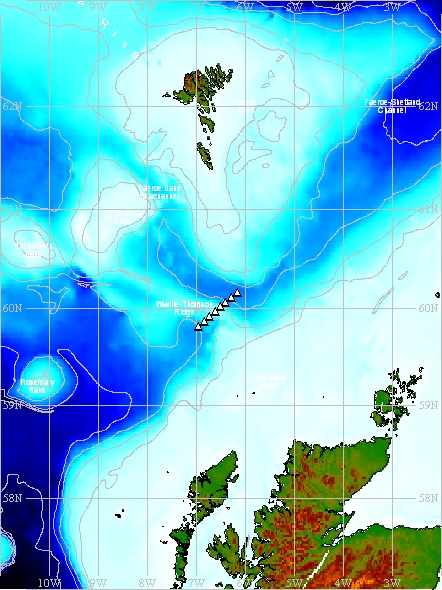
(Map produced using the GEBCO Digital Atlas)
The black triangles indicate the nominal positions of individual Line PA stations which make up the repeat section. Measurements made along Line PA lie within a box bounded by co-ordinates 59° 49.2' N, 6° 57.0' W at the south west corner and 60° 10.0' N, 6° 9.9' W at the north east corner.
Nominal Fixed Stations details
| Station | Nominal latitude | Nominal longitude | Approx. depth |
|---|---|---|---|
| PA2 | 59° 49.2' N | 6° 57.0' W | 1038 m |
| PA3 * | 59° 52.1' N | 6° 50.0' W | 935 m |
| PA4 | 59° 55.1' N | 6° 43.4' W | 618 m |
| PA5 | 59° 58.1' N | 6° 37.1' W | 330 m |
| PA6 | 60° 1.1' N | 6° 30.5' W | 467 m |
| PA7 | 60° 4.0' N | 6° 23.8' W | 1087 m |
| PA8 | 60° 7.0' N | 6° 16.7' W | 1166 m |
| PA9 ** | 60° 10.0' N | 6° 9.9' W | 1219 m |
* Station only occupied on cruise PO300_2 in 2003
** Station only occupied on cruise D321B in 2007
Related Fixed Station activities are detailed in Appendix 3
BODC Quality Control Flags
The following single character qualifying flags may be associated with one or more individual parameters with a data cycle:
| Flag | Description |
|---|---|
| Blank | Unqualified |
| < | Below detection limit |
| > | In excess of quoted value |
| A | Taxonomic flag for affinis (aff.) |
| B | Beginning of CTD Down/Up Cast |
| C | Taxonomic flag for confer (cf.) |
| D | Thermometric depth |
| E | End of CTD Down/Up Cast |
| G | Non-taxonomic biological characteristic uncertainty |
| H | Extrapolated value |
| I | Taxonomic flag for single species (sp.) |
| K | Improbable value - unknown quality control source |
| L | Improbable value - originator's quality control |
| M | Improbable value - BODC quality control |
| N | Null value |
| O | Improbable value - user quality control |
| P | Trace/calm |
| Q | Indeterminate |
| R | Replacement value |
| S | Estimated value |
| T | Interpolated value |
| U | Uncalibrated |
| W | Control value |
| X | Excessive difference |
SeaDataNet Quality Control Flags
The following single character qualifying flags may be associated with one or more individual parameters with a data cycle:
| Flag | Description |
|---|---|
| 0 | no quality control |
| 1 | good value |
| 2 | probably good value |
| 3 | probably bad value |
| 4 | bad value |
| 5 | changed value |
| 6 | value below detection |
| 7 | value in excess |
| 8 | interpolated value |
| 9 | missing value |
| A | value phenomenon uncertain |
| B | nominal value |
| Q | value below limit of quantification |
Appendix 1: Wyville Thomson Ridge
Related series for this Fixed Station are presented in the table below. Further information can be found by following the appropriate links.
If you are interested in these series, please be aware we offer a multiple file download service. Should your credentials be insufficient for automatic download, the service also offers a referral to our Enquiries Officer who may be able to negotiate access.
| Series Identifier | Data Category | Start date/time | Start position | Cruise |
|---|---|---|---|---|
| 626899 | CTD or STD cast | 2003-04-20 03:13:00 | 59.9437 N, 8.1305 W | FRV Scotia 0703S |
| 626906 | CTD or STD cast | 2003-04-20 04:00:00 | 59.955 N, 8.1967 W | FRV Scotia 0703S |
| 626918 | CTD or STD cast | 2003-04-20 04:47:00 | 59.9663 N, 8.2597 W | FRV Scotia 0703S |
| 626931 | CTD or STD cast | 2003-04-20 05:32:00 | 59.9792 N, 8.3025 W | FRV Scotia 0703S |
| 626943 | CTD or STD cast | 2003-04-20 07:12:00 | 59.9972 N, 8.3603 W | FRV Scotia 0703S |
| 626955 | CTD or STD cast | 2003-04-20 08:24:00 | 59.9943 N, 8.376 W | FRV Scotia 0703S |
| 626967 | CTD or STD cast | 2003-04-20 09:36:00 | 60.001 N, 8.4297 W | FRV Scotia 0703S |
| 626979 | CTD or STD cast | 2003-04-20 10:43:00 | 60.0072 N, 8.4618 W | FRV Scotia 0703S |
| 626980 | CTD or STD cast | 2003-04-20 11:42:00 | 60.011 N, 8.4943 W | FRV Scotia 0703S |
| 626992 | CTD or STD cast | 2003-04-20 12:53:00 | 60.0182 N, 8.5375 W | FRV Scotia 0703S |
| 627006 | CTD or STD cast | 2003-04-20 13:43:00 | 60.0252 N, 8.5728 W | FRV Scotia 0703S |
| 627018 | CTD or STD cast | 2003-04-20 14:42:00 | 60.0407 N, 8.6428 W | FRV Scotia 0703S |
| 627031 | CTD or STD cast | 2003-04-20 15:35:00 | 60.0655 N, 8.5973 W | FRV Scotia 0703S |
| 627043 | CTD or STD cast | 2003-04-20 16:22:00 | 60.0853 N, 8.5553 W | FRV Scotia 0703S |
| 627055 | CTD or STD cast | 2003-04-20 17:12:00 | 60.106 N, 8.5227 W | FRV Scotia 0703S |
| 627067 | CTD or STD cast | 2003-04-20 18:05:00 | 60.118 N, 8.5005 W | FRV Scotia 0703S |
| 627079 | CTD or STD cast | 2003-04-20 19:01:00 | 60.1338 N, 8.4765 W | FRV Scotia 0703S |
| 627080 | CTD or STD cast | 2003-04-20 20:03:00 | 60.1508 N, 8.4478 W | FRV Scotia 0703S |
| 627092 | CTD or STD cast | 2003-04-20 21:09:00 | 60.162 N, 8.4237 W | FRV Scotia 0703S |
| 627111 | CTD or STD cast | 2003-04-20 22:38:00 | 60.1813 N, 8.4073 W | FRV Scotia 0703S |
| 627123 | CTD or STD cast | 2003-04-20 23:51:00 | 60.2005 N, 8.384 W | FRV Scotia 0703S |
| 627135 | CTD or STD cast | 2003-04-21 01:50:00 | 60.2177 N, 8.3677 W | FRV Scotia 0703S |
| 627147 | CTD or STD cast | 2003-04-21 02:12:00 | 60.24 N, 8.3435 W | FRV Scotia 0703S |
| 627159 | CTD or STD cast | 2003-04-21 03:19:00 | 60.2483 N, 8.3317 W | FRV Scotia 0703S |
| 627160 | CTD or STD cast | 2003-04-21 04:25:00 | 60.2598 N, 8.3207 W | FRV Scotia 0703S |
| 627172 | CTD or STD cast | 2003-04-21 05:31:00 | 60.278 N, 8.3028 W | FRV Scotia 0703S |
| 627184 | CTD or STD cast | 2003-04-21 06:25:00 | 60.294 N, 8.2863 W | FRV Scotia 0703S |
| 627196 | CTD or STD cast | 2003-04-21 07:31:00 | 60.315 N, 8.2677 W | FRV Scotia 0703S |
| 627203 | CTD or STD cast | 2003-04-21 09:03:00 | 60.355 N, 8.2293 W | FRV Scotia 0703S |
| 627215 | CTD or STD cast | 2003-04-21 12:37:00 | 60.3955 N, 9.1597 W | FRV Scotia 0703S |
| 627227 | CTD or STD cast | 2003-04-21 13:34:00 | 60.3458 N, 9.1788 W | FRV Scotia 0703S |
| 627239 | CTD or STD cast | 2003-04-21 14:27:00 | 60.3262 N, 9.1877 W | FRV Scotia 0703S |
| 627240 | CTD or STD cast | 2003-04-21 15:30:00 | 60.3102 N, 9.1952 W | FRV Scotia 0703S |
| 627252 | CTD or STD cast | 2003-04-21 16:44:00 | 60.2928 N, 9.205 W | FRV Scotia 0703S |
| 627264 | CTD or STD cast | 2003-04-21 18:33:00 | 60.2698 N, 9.2032 W | FRV Scotia 0703S |
| 627276 | CTD or STD cast | 2003-04-21 20:19:00 | 60.2537 N, 9.2555 W | FRV Scotia 0703S |
| 627288 | CTD or STD cast | 2003-04-21 22:18:00 | 60.2255 N, 9.3653 W | FRV Scotia 0703S |
| 627307 | CTD or STD cast | 2003-04-22 00:26:00 | 60.2002 N, 9.4585 W | FRV Scotia 0703S |
| 627319 | CTD or STD cast | 2003-04-22 02:23:00 | 60.1778 N, 9.5617 W | FRV Scotia 0703S |
| 627320 | CTD or STD cast | 2003-04-22 04:06:00 | 60.1458 N, 9.6712 W | FRV Scotia 0703S |
| 627332 | CTD or STD cast | 2003-04-22 05:44:00 | 60.1642 N, 9.8153 W | FRV Scotia 0703S |
| 627344 | CTD or STD cast | 2003-04-22 07:10:00 | 60.2138 N, 9.8157 W | FRV Scotia 0703S |
| 627356 | CTD or STD cast | 2003-04-22 08:34:00 | 60.2682 N, 9.8153 W | FRV Scotia 0703S |
| 627368 | CTD or STD cast | 2003-04-22 09:53:00 | 60.321 N, 9.8142 W | FRV Scotia 0703S |
| 627381 | CTD or STD cast | 2003-04-22 11:16:00 | 60.352 N, 9.8158 W | FRV Scotia 0703S |
| 627393 | CTD or STD cast | 2003-04-22 12:31:00 | 60.375 N, 9.8165 W | FRV Scotia 0703S |
| 627400 | CTD or STD cast | 2003-04-22 13:51:00 | 60.4305 N, 9.814 W | FRV Scotia 0703S |
| 627412 | CTD or STD cast | 2003-04-22 14:48:00 | 60.447 N, 9.817 W | FRV Scotia 0703S |
| 627424 | CTD or STD cast | 2003-04-22 19:35:00 | 60.4005 N, 8.5665 W | FRV Scotia 0703S |
| 627436 | CTD or STD cast | 2003-04-22 20:45:00 | 60.3623 N, 8.4053 W | FRV Scotia 0703S |
| 627448 | CTD or STD cast | 2003-04-22 22:02:00 | 60.3165 N, 8.2693 W | FRV Scotia 0703S |
| 627461 | CTD or STD cast | 2003-04-22 23:22:00 | 60.2787 N, 8.1137 W | FRV Scotia 0703S |
| 627473 | CTD or STD cast | 2003-04-23 00:35:00 | 60.2423 N, 7.954 W | FRV Scotia 0703S |
| 627485 | CTD or STD cast | 2003-04-23 01:45:00 | 60.203 N, 7.815 W | FRV Scotia 0703S |
| 627497 | CTD or STD cast | 2003-04-23 02:47:00 | 60.1907 N, 7.7233 W | FRV Scotia 0703S |
| 627504 | CTD or STD cast | 2003-04-23 03:52:00 | 60.1787 N, 7.6223 W | FRV Scotia 0703S |
| 627516 | CTD or STD cast | 2003-04-23 05:10:00 | 60.1357 N, 7.4828 W | FRV Scotia 0703S |
| 627528 | CTD or STD cast | 2003-04-23 06:25:00 | 60.0737 N, 7.3432 W | FRV Scotia 0703S |
| 627541 | CTD or STD cast | 2003-04-23 07:37:00 | 60.0397 N, 7.1873 W | FRV Scotia 0703S |
| 627553 | CTD or STD cast | 2003-04-23 08:56:00 | 60.0032 N, 6.9805 W | FRV Scotia 0703S |
| 627565 | CTD or STD cast | 2003-04-23 09:48:00 | 59.9945 N, 6.8983 W | FRV Scotia 0703S |
| 627577 | CTD or STD cast | 2003-04-23 10:52:00 | 59.9922 N, 6.7567 W | FRV Scotia 0703S |
| 627589 | CTD or STD cast | 2003-04-23 12:04:00 | 59.9608 N, 6.5878 W | FRV Scotia 0703S |
| 627590 | CTD or STD cast | 2003-04-23 13:08:00 | 59.9173 N, 6.438 W | FRV Scotia 0703S |
| 627608 | CTD or STD cast | 2003-04-23 14:06:00 | 59.8697 N, 6.3035 W | FRV Scotia 0703S |
| 627621 | CTD or STD cast | 2003-04-23 15:08:00 | 59.8132 N, 6.2093 W | FRV Scotia 0703S |
| 627633 | CTD or STD cast | 2003-04-23 16:05:00 | 59.7498 N, 6.1825 W | FRV Scotia 0703S |
| 627645 | CTD or STD cast | 2003-04-25 18:19:00 | 60.0425 N, 6.5553 W | FRV Scotia 0703S |
| 627657 | CTD or STD cast | 2003-04-25 19:25:00 | 60.049 N, 6.6513 W | FRV Scotia 0703S |
| 627669 | CTD or STD cast | 2003-04-25 20:33:00 | 60.0512 N, 6.7603 W | FRV Scotia 0703S |
| 627670 | CTD or STD cast | 2003-04-25 21:48:00 | 60.044 N, 6.87 W | FRV Scotia 0703S |
| 627682 | CTD or STD cast | 2003-04-25 23:07:00 | 60.076 N, 6.9695 W | FRV Scotia 0703S |
| 627694 | CTD or STD cast | 2003-04-26 00:23:00 | 60.0898 N, 7.0712 W | FRV Scotia 0703S |
| 627701 | CTD or STD cast | 2003-04-26 01:35:00 | 60.1097 N, 7.1728 W | FRV Scotia 0703S |
| 627713 | CTD or STD cast | 2003-04-26 02:50:00 | 60.1325 N, 7.2478 W | FRV Scotia 0703S |
| 627725 | CTD or STD cast | 2003-04-26 04:10:00 | 60.152 N, 7.3427 W | FRV Scotia 0703S |
| 627737 | CTD or STD cast | 2003-04-26 05:43:00 | 60.1725 N, 7.4442 W | FRV Scotia 0703S |
| 627749 | CTD or STD cast | 2003-04-26 06:45:00 | 60.1993 N, 7.513 W | FRV Scotia 0703S |
| 627750 | CTD or STD cast | 2003-04-26 07:50:00 | 60.2232 N, 7.6033 W | FRV Scotia 0703S |
| 627762 | CTD or STD cast | 2003-04-26 12:44:00 | 60.4238 N, 9.2537 W | FRV Scotia 0703S |
| 627774 | CTD or STD cast | 2003-04-26 13:17:00 | 60.4063 N, 9.3028 W | FRV Scotia 0703S |
| 627786 | CTD or STD cast | 2003-04-26 13:52:00 | 60.3992 N, 9.3275 W | FRV Scotia 0703S |
| 627798 | CTD or STD cast | 2003-04-26 14:35:00 | 60.3898 N, 9.3512 W | FRV Scotia 0703S |
| 627805 | CTD or STD cast | 2003-04-26 15:39:00 | 60.3755 N, 9.3962 W | FRV Scotia 0703S |
| 627817 | CTD or STD cast | 2003-04-26 16:51:00 | 60.3558 N, 9.447 W | FRV Scotia 0703S |
| 627829 | CTD or STD cast | 2003-04-26 18:16:00 | 60.3848 N, 9.573 W | FRV Scotia 0703S |
| 627830 | CTD or STD cast | 2003-04-26 19:27:00 | 60.3998 N, 9.6482 W | FRV Scotia 0703S |
| 627842 | CTD or STD cast | 2003-04-26 20:29:00 | 60.4075 N, 9.6843 W | FRV Scotia 0703S |
| 627854 | CTD or STD cast | 2003-04-26 21:30:00 | 60.415 N, 9.7168 W | FRV Scotia 0703S |
| 627866 | CTD or STD cast | 2003-04-26 22:31:00 | 60.4253 N, 9.7618 W | FRV Scotia 0703S |
| 627878 | CTD or STD cast | 2003-04-26 23:29:00 | 60.454 N, 9.764 W | FRV Scotia 0703S |
| 627891 | CTD or STD cast | 2003-04-27 00:16:00 | 60.457 N, 9.6963 W | FRV Scotia 0703S |
| 627909 | CTD or STD cast | 2003-04-27 01:11:00 | 60.4598 N, 9.6118 W | FRV Scotia 0703S |
| 627910 | CTD or STD cast | 2003-04-27 03:13:00 | 60.4667 N, 9.5283 W | FRV Scotia 0703S |
| 627922 | CTD or STD cast | 2003-04-27 03:53:00 | 60.4702 N, 9.4908 W | FRV Scotia 0703S |
| 627934 | CTD or STD cast | 2003-04-27 04:37:00 | 60.4723 N, 9.4308 W | FRV Scotia 0703S |
| 627946 | CTD or STD cast | 2003-04-27 05:30:00 | 60.482 N, 9.2873 W | FRV Scotia 0703S |
| 627958 | CTD or STD cast | 2003-04-27 06:48:00 | 60.4942 N, 9.0017 W | FRV Scotia 0703S |
| 627971 | CTD or STD cast | 2003-04-27 07:50:00 | 60.4307 N, 8.8362 W | FRV Scotia 0703S |
| 627983 | CTD or STD cast | 2003-04-27 08:39:00 | 60.3682 N, 8.8527 W | FRV Scotia 0703S |
| 627995 | CTD or STD cast | 2003-04-27 09:18:00 | 60.3363 N, 8.8638 W | FRV Scotia 0703S |
| 628009 | CTD or STD cast | 2003-04-27 10:05:00 | 60.3005 N, 8.8818 W | FRV Scotia 0703S |
| 628010 | CTD or STD cast | 2003-04-27 11:11:00 | 60.267 N, 8.8903 W | FRV Scotia 0703S |
| 628022 | CTD or STD cast | 2003-04-27 12:05:00 | 60.2442 N, 8.9063 W | FRV Scotia 0703S |
| 628034 | CTD or STD cast | 2003-04-27 13:22:00 | 60.224 N, 8.9128 W | FRV Scotia 0703S |
| 628046 | CTD or STD cast | 2003-04-27 14:11:00 | 60.2093 N, 8.9155 W | FRV Scotia 0703S |
| 628058 | CTD or STD cast | 2003-04-27 15:02:00 | 60.179 N, 8.9295 W | FRV Scotia 0703S |
| 628071 | CTD or STD cast | 2003-04-27 16:28:00 | 60.2712 N, 9.2132 W | FRV Scotia 0703S |
| 628083 | CTD or STD cast | 2003-04-27 17:52:00 | 60.282 N, 9.1667 W | FRV Scotia 0703S |
| 628095 | CTD or STD cast | 2003-04-27 19:28:00 | 60.292 N, 9.1312 W | FRV Scotia 0703S |
| 628102 | CTD or STD cast | 2003-04-27 20:31:00 | 60.2993 N, 9.0868 W | FRV Scotia 0703S |
| 628114 | CTD or STD cast | 2003-04-27 21:23:00 | 60.3128 N, 9.0282 W | FRV Scotia 0703S |
| 628126 | CTD or STD cast | 2003-04-27 22:48:00 | 60.2952 N, 9.018 W | FRV Scotia 0703S |
| 628138 | CTD or STD cast | 2003-04-27 23:32:00 | 60.2785 N, 9.0142 W | FRV Scotia 0703S |
| 628151 | CTD or STD cast | 2003-04-28 00:23:00 | 60.2622 N, 9.01 W | FRV Scotia 0703S |
| 628163 | CTD or STD cast | 2003-04-28 01:25:00 | 60.2495 N, 9.0072 W | FRV Scotia 0703S |
| 628175 | CTD or STD cast | 2003-04-28 02:38:00 | 60.2302 N, 8.9903 W | FRV Scotia 0703S |
| 628187 | CTD or STD cast | 2003-04-28 03:45:00 | 60.2085 N, 8.9617 W | FRV Scotia 0703S |
| 628199 | CTD or STD cast | 2003-04-28 04:52:00 | 60.148 N, 8.8472 W | FRV Scotia 0703S |
| 628206 | CTD or STD cast | 2003-04-28 05:37:00 | 60.1795 N, 8.763 W | FRV Scotia 0703S |
| 628218 | CTD or STD cast | 2003-04-28 06:26:00 | 60.1982 N, 8.6935 W | FRV Scotia 0703S |
| 628231 | CTD or STD cast | 2003-04-28 07:23:00 | 60.223 N, 8.6103 W | FRV Scotia 0703S |
| 628243 | CTD or STD cast | 2003-04-28 08:18:00 | 60.264 N, 8.5852 W | FRV Scotia 0703S |
| 628255 | CTD or STD cast | 2003-04-28 09:16:00 | 60.3072 N, 8.5597 W | FRV Scotia 0703S |
| 628267 | CTD or STD cast | 2003-04-28 10:05:00 | 60.3422 N, 8.5412 W | FRV Scotia 0703S |
| 628279 | CTD or STD cast | 2003-04-28 10:53:00 | 60.3888 N, 8.5135 W | FRV Scotia 0703S |
| 628280 | CTD or STD cast | 2003-04-28 14:35:00 | 60.1753 N, 9.5588 W | FRV Scotia 0703S |
| 628292 | CTD or STD cast | 2003-04-28 15:40:00 | 60.1757 N, 9.4652 W | FRV Scotia 0703S |
| 628311 | CTD or STD cast | 2003-04-28 16:49:00 | 60.1782 N, 9.375 W | FRV Scotia 0703S |
| 628323 | CTD or STD cast | 2003-04-28 18:09:00 | 60.1783 N, 9.2328 W | FRV Scotia 0703S |
| 628335 | CTD or STD cast | 2003-04-28 19:34:00 | 60.1775 N, 9.0308 W | FRV Scotia 0703S |
| 628347 | CTD or STD cast | 2003-04-28 21:55:00 | 60.1493 N, 8.452 W | FRV Scotia 0703S |
| 845261 | CTD or STD cast | 2003-07-27 18:51:00 | 59.71597 N, 7.15278 W | Poseidon PO300_2 |
| 845273 | CTD or STD cast | 2003-07-28 20:39:00 | 59.8202 N, 6.95063 W | Poseidon PO300_2 |
| 845285 | CTD or STD cast | 2003-07-28 22:15:00 | 59.86838 N, 6.83345 W | Poseidon PO300_2 |
| 845297 | CTD or STD cast | 2003-07-29 00:00:00 | 59.91805 N, 6.7241 W | Poseidon PO300_2 |
| 845304 | CTD or STD cast | 2003-07-29 01:29:00 | 59.96848 N, 6.61855 W | Poseidon PO300_2 |
| 845316 | CTD or STD cast | 2003-07-29 02:52:00 | 60.01832 N, 6.5087 W | Poseidon PO300_2 |
| 845328 | CTD or STD cast | 2003-07-29 20:02:00 | 60.168 N, 6.16677 W | Poseidon PO300_2 |
| 845341 | CTD or STD cast | 2003-07-29 22:13:00 | 60.11595 N, 6.27883 W | Poseidon PO300_2 |
| 845365 | CTD or STD cast | 2003-07-30 01:24:00 | 60.0279 N, 6.48653 W | Poseidon PO300_2 |
| 845377 | CTD or STD cast | 2003-07-30 02:49:00 | 60.05145 N, 6.63285 W | Poseidon PO300_2 |
| 845389 | CTD or STD cast | 2003-07-30 09:46:00 | 60.10163 N, 6.09385 W | Poseidon PO300_2 |
| 845390 | CTD or STD cast | 2003-07-30 16:22:00 | 60.0508 N, 6.81967 W | Poseidon PO300_2 |
| 845408 | CTD or STD cast | 2003-07-30 17:41:00 | 60.08522 N, 6.93385 W | Poseidon PO300_2 |
| 845421 | CTD or STD cast | 2003-07-30 19:03:00 | 60.11207 N, 7.06995 W | Poseidon PO300_2 |
| 845433 | CTD or STD cast | 2003-07-30 20:52:00 | 60.14212 N, 7.23043 W | Poseidon PO300_2 |
| 845445 | CTD or STD cast | 2003-07-30 22:24:00 | 60.1744 N, 7.38717 W | Poseidon PO300_2 |
| 845457 | CTD or STD cast | 2003-07-30 23:43:00 | 60.20735 N, 7.53108 W | Poseidon PO300_2 |
| 845469 | CTD or STD cast | 2003-07-31 00:56:00 | 60.2355 N, 7.6598 W | Poseidon PO300_2 |
| 845470 | CTD or STD cast | 2003-07-31 02:13:00 | 60.26925 N, 7.80108 W | Poseidon PO300_2 |
| 845482 | CTD or STD cast | 2003-07-31 03:32:00 | 60.2949 N, 7.9169 W | Poseidon PO300_2 |
| 845494 | CTD or STD cast | 2003-08-01 05:17:00 | 60.1811 N, 7.73665 W | Poseidon PO300_2 |
| 1014447 | Currents -subsurface Eulerian | 2003-08-01 09:30:00 | 60.183 N, 7.7338 W | Poseidon PO300_2 |
| 1014435 | Currents -subsurface Eulerian | 2003-09-28 19:30:00 | 60.23917 N, 8.86833 W | FRV Scotia 1403S |
| 896598 | CTD or STD cast | 2005-10-14 09:31:00 | 60.2159 N, 6.19836 W | RRS Charles Darwin CD176 |
| 896605 | CTD or STD cast | 2005-10-14 11:20:00 | 60.21326 N, 6.20296 W | RRS Charles Darwin CD176 |
| 896617 | CTD or STD cast | 2005-10-14 13:53:00 | 60.29942 N, 6.11356 W | RRS Charles Darwin CD176 |
| 896629 | CTD or STD cast | 2005-10-14 23:59:00 | 60.08054 N, 6.32135 W | RRS Charles Darwin CD176 |
| 896630 | CTD or STD cast | 2005-10-15 02:04:00 | 60.0144 N, 6.34818 W | RRS Charles Darwin CD176 |
| 896642 | CTD or STD cast | 2005-10-15 23:45:00 | 60.33948 N, 9.0409 W | RRS Charles Darwin CD176 |
| 896654 | CTD or STD cast | 2005-10-16 01:45:00 | 60.28932 N, 9.02996 W | RRS Charles Darwin CD176 |
| 896666 | CTD or STD cast | 2005-10-16 03:38:00 | 60.27818 N, 9.01476 W | RRS Charles Darwin CD176 |
| 896678 | CTD or STD cast | 2005-10-16 05:30:00 | 60.26256 N, 9.0105 W | RRS Charles Darwin CD176 |
| 896691 | CTD or STD cast | 2005-10-16 07:55:00 | 60.24946 N, 9.00726 W | RRS Charles Darwin CD176 |
| 896709 | CTD or STD cast | 2005-10-16 10:51:00 | 60.22923 N, 8.99213 W | RRS Charles Darwin CD176 |
| 896710 | CTD or STD cast | 2005-10-16 12:46:00 | 60.18908 N, 8.96128 W | RRS Charles Darwin CD176 |
| 1014459 | Currents -subsurface Eulerian | 2005-10-16 15:30:00 | 60.23942 N, 8.86997 W | RRS Charles Darwin CD176 |
| 896722 | CTD or STD cast | 2005-10-16 21:16:00 | 60.4263 N, 8.24386 W | RRS Charles Darwin CD176 |
| 1014460 | Currents -subsurface Eulerian | 2006-05-07 08:02:41 | 60.2495 N, 8.91 W | FRV Scotia 0706S |
| 776793 | CTD or STD cast | 2006-10-28 04:24:44 | 60.34267 N, 8.99217 W | RRS Discovery D312 |
| 776800 | CTD or STD cast | 2006-10-28 05:48:17 | 60.3115 N, 8.94867 W | RRS Discovery D312 |
| 776812 | CTD or STD cast | 2006-10-28 07:45:53 | 60.298 N, 8.932 W | RRS Discovery D312 |
| 776824 | CTD or STD cast | 2006-10-28 09:33:32 | 60.26583 N, 8.91833 W | RRS Discovery D312 |
| 776836 | CTD or STD cast | 2006-10-28 12:38:43 | 60.284 N, 8.92417 W | RRS Discovery D312 |
| 776848 | CTD or STD cast | 2006-10-28 14:06:35 | 60.255 N, 8.91567 W | RRS Discovery D312 |
| 1014472 | Currents -subsurface Eulerian | 2006-10-28 16:33:08 | 60.25 N, 8.9165 W | RRS Discovery D312 |
| 776861 | CTD or STD cast | 2006-10-28 16:54:10 | 60.2365 N, 8.91617 W | RRS Discovery D312 |
| 776873 | CTD or STD cast | 2006-10-28 19:32:14 | 60.22717 N, 8.917 W | RRS Discovery D312 |
| 847673 | CTD or STD cast | 2007-09-02 15:12:51 | 60.24698 N, 9.00905 W | RRS Discovery D321B |
| 1014484 | Currents -subsurface Eulerian | 2007-09-02 17:45:00 | 60.24517 N, 9.01267 W | RRS Discovery D321B |
| 847685 | CTD or STD cast | 2007-09-02 22:31:15 | 60.54961 N, 8.1944 W | RRS Discovery D321B |
| 847697 | CTD or STD cast | 2007-09-03 03:34:58 | 60.59987 N, 8.28802 W | RRS Discovery D321B |
| 847704 | CTD or STD cast | 2007-09-03 04:13:23 | 60.60423 N, 8.28849 W | RRS Discovery D321B |
| 847901 | CTD or STD cast | 2007-09-04 08:08:33 | 60.59981 N, 8.1302 W | RRS Discovery D321B |
| 847716 | CTD or STD cast | 2007-09-04 17:39:37 | 60.57216 N, 7.48264 W | RRS Discovery D321B |
| 847728 | CTD or STD cast | 2007-09-05 00:40:48 | 60.3882 N, 7.25541 W | RRS Discovery D321B |
| 847741 | CTD or STD cast | 2007-09-05 08:32:53 | 60.26364 N, 6.84096 W | RRS Discovery D321B |
| 847753 | CTD or STD cast | 2007-09-07 01:58:25 | 60.16545 N, 6.16475 W | RRS Discovery D321B |
| 847765 | CTD or STD cast | 2007-09-07 04:20:22 | 60.11849 N, 6.27459 W | RRS Discovery D321B |
| 847777 | CTD or STD cast | 2007-09-07 06:23:34 | 60.06818 N, 6.38362 W | RRS Discovery D321B |
| 847789 | CTD or STD cast | 2007-09-07 08:13:00 | 60.0348 N, 6.41938 W | RRS Discovery D321B |
| 847790 | CTD or STD cast | 2007-09-07 11:03:00 | 60.01627 N, 6.50561 W | RRS Discovery D321B |
| 847808 | CTD or STD cast | 2007-09-07 12:27:38 | 59.96778 N, 6.62012 W | RRS Discovery D321B |
| 847821 | CTD or STD cast | 2007-09-07 13:46:35 | 59.91902 N, 6.73161 W | RRS Discovery D321B |
| 847833 | CTD or STD cast | 2007-09-07 15:43:43 | 59.8233 N, 6.95149 W | RRS Discovery D321B |
| 1623433 | Currents -subsurface Eulerian | 2008-05-18 20:55:00 | 60.24517 N, 9.01267 W | FRV Scotia 0508S |
| 1623445 | Currents -subsurface Eulerian | 2008-06-18 00:10:00 | 60.24517 N, 9.01267 W | FRV Scotia 0508S |
| 1623457 | Currents -subsurface Eulerian | 2008-07-18 00:10:00 | 60.24517 N, 9.01267 W | FRV Scotia 0508S |
| 1623469 | Currents -subsurface Eulerian | 2008-08-18 00:10:00 | 60.24517 N, 9.01267 W | FRV Scotia 0508S |
| 1623470 | Currents -subsurface Eulerian | 2008-09-18 00:10:00 | 60.24517 N, 9.01267 W | FRV Scotia 0508S |
| 1623482 | Currents -subsurface Eulerian | 2008-10-18 00:10:00 | 60.24517 N, 9.01267 W | FRV Scotia 0508S |
| 1623494 | Currents -subsurface Eulerian | 2008-11-18 00:10:00 | 60.24517 N, 9.01267 W | FRV Scotia 0508S |
| 1623501 | Currents -subsurface Eulerian | 2008-12-18 00:10:00 | 60.24517 N, 9.01267 W | FRV Scotia 0508S |
| 1623513 | Currents -subsurface Eulerian | 2009-01-18 00:10:00 | 60.24517 N, 9.01267 W | FRV Scotia 0508S |
| 1623525 | Currents -subsurface Eulerian | 2009-02-18 00:10:00 | 60.24517 N, 9.01267 W | FRV Scotia 0508S |
| 1623537 | Currents -subsurface Eulerian | 2009-03-18 00:10:00 | 60.24517 N, 9.01267 W | FRV Scotia 0508S |
| 1623549 | Currents -subsurface Eulerian | 2009-04-18 00:10:00 | 60.24517 N, 9.01267 W | FRV Scotia 0508S |
| 1623550 | Currents -subsurface Eulerian | 2009-05-18 00:10:00 | 60.24517 N, 9.01267 W | FRV Scotia 0508S |
| 954401 | CTD or STD cast | 2009-06-21 16:07:50 | 60.20665 N, 8.95695 W | RRS Discovery D340A |
| 954413 | CTD or STD cast | 2009-06-21 17:20:27 | 60.2186 N, 8.97383 W | RRS Discovery D340A |
| 954425 | CTD or STD cast | 2009-06-21 18:21:56 | 60.22989 N, 8.99 W | RRS Discovery D340A |
| 954437 | CTD or STD cast | 2009-06-21 19:58:18 | 60.24991 N, 9.00529 W | RRS Discovery D340A |
| 954449 | CTD or STD cast | 2009-06-21 21:11:56 | 60.26127 N, 9.00824 W | RRS Discovery D340A |
| 954450 | CTD or STD cast | 2009-06-21 22:24:23 | 60.2783 N, 9.01223 W | RRS Discovery D340A |
| 954462 | CTD or STD cast | 2009-06-22 00:03:16 | 60.29325 N, 9.01763 W | RRS Discovery D340A |
| 954474 | CTD or STD cast | 2009-06-22 01:20:57 | 60.33382 N, 9.02786 W | RRS Discovery D340A |
| 954486 | CTD or STD cast | 2009-06-22 03:05:44 | 60.38812 N, 9.03649 W | RRS Discovery D340A |
| 954498 | CTD or STD cast | 2009-06-22 04:49:33 | 60.26206 N, 9.00946 W | RRS Discovery D340A |
| 954505 | CTD or STD cast | 2009-06-22 07:35:09 | 60.23988 N, 8.99759 W | RRS Discovery D340A |
| 954517 | CTD or STD cast | 2009-06-22 10:33:56 | 60.29171 N, 9.12969 W | RRS Discovery D340A |
| 954529 | CTD or STD cast | 2009-06-22 11:52:23 | 60.26806 N, 9.20608 W | RRS Discovery D340A |
| 954530 | CTD or STD cast | 2009-06-22 14:20:10 | 60.24754 N, 9.28554 W | RRS Discovery D340A |
| 954542 | CTD or STD cast | 2009-06-22 16:21:18 | 60.22707 N, 9.36207 W | RRS Discovery D340A |
| 954554 | CTD or STD cast | 2009-06-22 18:09:24 | 60.19218 N, 9.49349 W | RRS Discovery D340A |
| 954566 | CTD or STD cast | 2009-06-22 20:32:12 | 60.35444 N, 9.44191 W | RRS Discovery D340A |
| 954578 | CTD or STD cast | 2009-06-22 22:40:14 | 60.31848 N, 9.35247 W | RRS Discovery D340A |
| 954591 | CTD or STD cast | 2009-06-23 00:28:59 | 60.29054 N, 9.27921 W | RRS Discovery D340A |
| 954609 | CTD or STD cast | 2009-06-23 02:46:20 | 60.25009 N, 9.15898 W | RRS Discovery D340A |
| 954610 | CTD or STD cast | 2009-06-23 04:30:26 | 60.22413 N, 9.07486 W | RRS Discovery D340A |
| 954622 | CTD or STD cast | 2009-06-23 07:27:28 | 60.25882 N, 9.12326 W | RRS Discovery D340A |
| 954634 | CTD or STD cast | 2009-06-23 09:32:52 | 60.24685 N, 9.06133 W | RRS Discovery D340A |
| 954646 | CTD or STD cast | 2009-06-23 11:27:59 | 60.24213 N, 8.91099 W | RRS Discovery D340A |
| 954658 | CTD or STD cast | 2009-06-23 13:21:42 | 60.24256 N, 8.81257 W | RRS Discovery D340A |
| 954671 | CTD or STD cast | 2009-06-23 15:41:22 | 60.24605 N, 9.0164 W | RRS Discovery D340A |
| 1639619 | Currents -subsurface Eulerian | 2011-05-12 08:30:00 | 60.2475 N, 8.92166 W | FRV Scotia 0511S |
| 1639620 | Currents -subsurface Eulerian | 2011-06-12 00:00:00 | 60.2475 N, 8.92166 W | FRV Scotia 0511S |
| 1639632 | Currents -subsurface Eulerian | 2011-07-12 00:00:00 | 60.2475 N, 8.92166 W | FRV Scotia 0511S |
| 1639644 | Currents -subsurface Eulerian | 2011-08-12 00:00:00 | 60.2475 N, 8.92166 W | FRV Scotia 0511S |
| 1639656 | Currents -subsurface Eulerian | 2011-09-12 00:00:00 | 60.2475 N, 8.92166 W | FRV Scotia 0511S |
| 1639668 | Currents -subsurface Eulerian | 2011-10-12 00:00:00 | 60.2475 N, 8.92166 W | FRV Scotia 0511S |
| 1639681 | Currents -subsurface Eulerian | 2011-11-12 00:00:00 | 60.2475 N, 8.92166 W | FRV Scotia 0511S |
| 1639693 | Currents -subsurface Eulerian | 2011-12-12 00:00:00 | 60.2475 N, 8.92166 W | FRV Scotia 0511S |
| 1639700 | Currents -subsurface Eulerian | 2012-01-12 00:14:59 | 60.2475 N, 8.92166 W | FRV Scotia 0511S |
| 1639712 | Currents -subsurface Eulerian | 2012-02-12 00:14:59 | 60.2475 N, 8.92166 W | FRV Scotia 0511S |
| 1639724 | Currents -subsurface Eulerian | 2012-03-12 00:14:59 | 60.2475 N, 8.92166 W | FRV Scotia 0511S |
| 1639736 | Currents -subsurface Eulerian | 2012-04-12 00:14:59 | 60.2475 N, 8.92166 W | FRV Scotia 0511S |
| 1639748 | Currents -subsurface Eulerian | 2012-05-12 00:14:59 | 60.2475 N, 8.92166 W | FRV Scotia 0511S |
| 1203661 | CTD or STD cast | 2012-08-06 18:18:00 | 60.38833 N, 8.51243 W | RRS Discovery D379 |
| 1203673 | CTD or STD cast | 2012-08-06 19:59:00 | 60.34098 N, 8.53872 W | RRS Discovery D379 |
| 1203685 | CTD or STD cast | 2012-08-06 21:42:00 | 60.308 N, 8.55094 W | RRS Discovery D379 |
| 1203697 | CTD or STD cast | 2012-08-06 23:36:00 | 60.26418 N, 8.57292 W | RRS Discovery D379 |
| 1203704 | CTD or STD cast | 2012-08-07 01:02:00 | 60.21951 N, 8.60904 W | RRS Discovery D379 |
| 1203716 | CTD or STD cast | 2012-08-07 03:03:00 | 60.19408 N, 8.69338 W | RRS Discovery D379 |
| 1203728 | CTD or STD cast | 2012-08-07 04:39:00 | 60.17799 N, 8.762 W | RRS Discovery D379 |
| 1203741 | CTD or STD cast | 2012-08-07 06:05:00 | 60.14615 N, 8.84574 W | RRS Discovery D379 |
| 1203753 | CTD or STD cast | 2012-08-07 07:43:00 | 60.20816 N, 8.96124 W | RRS Discovery D379 |
| 1203765 | CTD or STD cast | 2012-08-07 09:21:00 | 60.25059 N, 8.90955 W | RRS Discovery D379 |
| 1203777 | CTD or STD cast | 2012-08-07 12:28:00 | 60.23005 N, 8.98769 W | RRS Discovery D379 |
| 1203789 | CTD or STD cast | 2012-08-07 14:08:00 | 60.24506 N, 9.00491 W | RRS Discovery D379 |
| 1639515 | Currents -subsurface Eulerian | 2012-08-07 17:00:00 | 60.24996 N, 8.90965 W | RRS Discovery D379 |
| 1203790 | CTD or STD cast | 2012-08-07 17:35:00 | 60.26122 N, 9.00856 W | RRS Discovery D379 |
| 1640669 | Hydrography time series at depth | 2012-08-07 18:14:58 | 60.24996 N, 8.90965 W | RRS Discovery D379 |
| 1203808 | CTD or STD cast | 2012-08-07 19:24:00 | 60.27805 N, 9.01287 W | RRS Discovery D379 |
| 1203821 | CTD or STD cast | 2012-08-07 20:47:00 | 60.2944 N, 9.01618 W | RRS Discovery D379 |
| 1203833 | CTD or STD cast | 2012-08-07 22:06:00 | 60.31188 N, 9.02541 W | RRS Discovery D379 |
| 1639527 | Currents -subsurface Eulerian | 2012-09-07 00:14:59 | 60.24996 N, 8.90965 W | RRS Discovery D379 |
| 1639539 | Currents -subsurface Eulerian | 2012-10-07 00:14:59 | 60.24996 N, 8.90965 W | RRS Discovery D379 |
| 1639540 | Currents -subsurface Eulerian | 2012-11-07 00:14:59 | 60.24996 N, 8.90965 W | RRS Discovery D379 |
| 1639552 | Currents -subsurface Eulerian | 2012-12-07 00:14:59 | 60.24996 N, 8.90965 W | RRS Discovery D379 |
| 1639564 | Currents -subsurface Eulerian | 2013-01-07 00:14:59 | 60.24996 N, 8.90965 W | RRS Discovery D379 |
| 1639576 | Currents -subsurface Eulerian | 2013-02-07 00:14:59 | 60.24996 N, 8.90965 W | RRS Discovery D379 |
| 1639588 | Currents -subsurface Eulerian | 2013-03-07 00:14:59 | 60.24996 N, 8.90965 W | RRS Discovery D379 |
| 1639607 | Currents -subsurface Eulerian | 2013-04-07 00:14:59 | 60.24996 N, 8.90965 W | RRS Discovery D379 |
| 1219964 | CTD or STD cast | 2013-05-08 10:50:00 | 60.2078 N, 8.9611 W | RRS James Cook JC086 |
| 1219976 | CTD or STD cast | 2013-05-08 12:27:08 | 60.23 N, 8.99 W | RRS James Cook JC086 |
| 2101073 | Water sample data | 2013-05-08 13:06:30 | 60.4375 N, 9.09222 W | RRS James Cook JC086 |
| 1219988 | CTD or STD cast | 2013-05-08 14:45:52 | 60.2558 N, 9.0073 W | RRS James Cook JC086 |
| 2101085 | Water sample data | 2013-05-08 15:17:30 | 60.34611 N, 9.12111 W | RRS James Cook JC086 |
| 2101687 | Water sample data | 2013-05-08 15:17:30 | 60.34611 N, 9.12111 W | RRS James Cook JC086 |
| 1220001 | CTD or STD cast | 2013-05-08 16:38:43 | 60.2611 N, 9.008 W | RRS James Cook JC086 |
| 2101097 | Water sample data | 2013-05-08 17:15:00 | 60.435 N, 9.13389 W | RRS James Cook JC086 |
| 2101699 | Water sample data | 2013-05-08 17:15:00 | 60.435 N, 9.13389 W | RRS James Cook JC086 |
| 1220013 | CTD or STD cast | 2013-05-08 18:38:04 | 60.277 N, 9.0131 W | RRS James Cook JC086 |
| 2101104 | Water sample data | 2013-05-08 19:07:00 | 60.43833 N, 9.2175 W | RRS James Cook JC086 |
| 2101706 | Water sample data | 2013-05-08 19:07:00 | 60.43833 N, 9.2175 W | RRS James Cook JC086 |
| 1220025 | CTD or STD cast | 2013-05-08 20:22:12 | 60.295 N, 9.0161 W | RRS James Cook JC086 |
Appendix 2: DML Line PA Station PA7
Related series for this Fixed Station are presented in the table below. Further information can be found by following the appropriate links.
If you are interested in these series, please be aware we offer a multiple file download service. Should your credentials be insufficient for automatic download, the service also offers a referral to our Enquiries Officer who may be able to negotiate access.
| Series Identifier | Data Category | Start date/time | Start position | Cruise |
|---|---|---|---|---|
| 847777 | CTD or STD cast | 2007-09-07 06:23:34 | 60.06818 N, 6.38362 W | RRS Discovery D321B |
Appendix 3: DML Line PA
Related series for this Fixed Station are presented in the table below. Further information can be found by following the appropriate links.
If you are interested in these series, please be aware we offer a multiple file download service. Should your credentials be insufficient for automatic download, the service also offers a referral to our Enquiries Officer who may be able to negotiate access.
| Series Identifier | Data Category | Start date/time | Start position | Cruise |
|---|---|---|---|---|
| 845273 | CTD or STD cast | 2003-07-28 20:39:00 | 59.8202 N, 6.95063 W | Poseidon PO300_2 |
| 845285 | CTD or STD cast | 2003-07-28 22:15:00 | 59.86838 N, 6.83345 W | Poseidon PO300_2 |
| 845297 | CTD or STD cast | 2003-07-29 00:00:00 | 59.91805 N, 6.7241 W | Poseidon PO300_2 |
| 845304 | CTD or STD cast | 2003-07-29 01:29:00 | 59.96848 N, 6.61855 W | Poseidon PO300_2 |
| 845316 | CTD or STD cast | 2003-07-29 02:52:00 | 60.01832 N, 6.5087 W | Poseidon PO300_2 |
| 845341 | CTD or STD cast | 2003-07-29 22:13:00 | 60.11595 N, 6.27883 W | Poseidon PO300_2 |
| 847753 | CTD or STD cast | 2007-09-07 01:58:25 | 60.16545 N, 6.16475 W | RRS Discovery D321B |
| 847765 | CTD or STD cast | 2007-09-07 04:20:22 | 60.11849 N, 6.27459 W | RRS Discovery D321B |
| 847777 | CTD or STD cast | 2007-09-07 06:23:34 | 60.06818 N, 6.38362 W | RRS Discovery D321B |
| 847790 | CTD or STD cast | 2007-09-07 11:03:00 | 60.01627 N, 6.50561 W | RRS Discovery D321B |
| 847808 | CTD or STD cast | 2007-09-07 12:27:38 | 59.96778 N, 6.62012 W | RRS Discovery D321B |
| 847821 | CTD or STD cast | 2007-09-07 13:46:35 | 59.91902 N, 6.73161 W | RRS Discovery D321B |
| 847833 | CTD or STD cast | 2007-09-07 15:43:43 | 59.8233 N, 6.95149 W | RRS Discovery D321B |
