Metadata Report for BODC Series Reference Number 847777
Metadata Summary
Problem Reports
Data Access Policy
Narrative Documents
Project Information
Data Activity or Cruise Information
Fixed Station Information
BODC Quality Flags
SeaDataNet Quality Flags
Metadata Summary
Data Description |
|||||||||||||||||||||||||||||||||
|
|||||||||||||||||||||||||||||||||
Data Identifiers |
|||||||||||||||||||||||||||||||||
|
|||||||||||||||||||||||||||||||||
Time Co-ordinates(UT) |
|||||||||||||||||||||||||||||||||
|
|||||||||||||||||||||||||||||||||
Spatial Co-ordinates | |||||||||||||||||||||||||||||||||
|
|||||||||||||||||||||||||||||||||
Parameters |
|||||||||||||||||||||||||||||||||
|
|||||||||||||||||||||||||||||||||
|
|||||||||||||||||||||||||||||||||
Problem Reports
Severe contamination of the CTD data has been identified by the data originator due to a surging problem affecting the temperature, salinity and oxygen (and possibly other) channels on all casts from the cruise D321B. A number of regular blips were identified in the profiles and have been attributed to the roll of the ship in the swell due to the winch system adopted on board not compensating for ship heave. These parts of the dataset have not been removed during data processing and have not been flagged as it is difficult to establish which data are erroneous but users should be aware that this problem exists.
Data Access Policy
Open Data
These data have no specific confidentiality restrictions for users. However, users must acknowledge data sources as it is not ethical to publish data without proper attribution. Any publication or other output resulting from usage of the data should include an acknowledgment.
If the Information Provider does not provide a specific attribution statement, or if you are using Information from several Information Providers and multiple attributions are not practical in your product or application, you may consider using the following:
"Contains public sector information licensed under the Open Government Licence v1.0."
Narrative Documents
Sea-Bird Dissolved Oxygen Sensor SBE 43 and SBE 43F
The SBE 43 is a dissolved oxygen sensor designed for marine applications. It incorporates a high-performance Clark polarographic membrane with a pump that continuously plumbs water through it, preventing algal growth and the development of anoxic conditions when the sensor is taking measurements.
Two configurations are available: SBE 43 produces a voltage output and can be incorporated with any Sea-Bird CTD that accepts input from a 0-5 volt auxiliary sensor, while the SBE 43F produces a frequency output and can be integrated with an SBE 52-MP (Moored Profiler CTD) or used for OEM applications. The specifications below are common to both.
Specifications
| Housing | Plastic or titanium |
| Membrane | 0.5 mil- fast response, typical for profile applications 1 mil- slower response, typical for moored applications |
| Depth rating | 600 m (plastic) or 7000 m (titanium) 10500 m titanium housing available on request |
| Measurement range | 120% of surface saturation |
| Initial accuracy | 2% of saturation |
| Typical stability | 0.5% per 1000 h |
Further details can be found in the manufacturer's specification sheet.
Sea-Bird Electronics SBE 911 and SBE 917 series CTD profilers
The SBE 911 and SBE 917 series of conductivity-temperature-depth (CTD) units are used to collect hydrographic profiles, including temperature, conductivity and pressure as standard. Each profiler consists of an underwater unit and deck unit or SEARAM. Auxiliary sensors, such as fluorometers, dissolved oxygen sensors and transmissometers, and carousel water samplers are commonly added to the underwater unit.
Underwater unit
The CTD underwater unit (SBE 9 or SBE 9 plus) comprises a protective cage (usually with a carousel water sampler), including a main pressure housing containing power supplies, acquisition electronics, telemetry circuitry, and a suite of modular sensors. The original SBE 9 incorporated Sea-Bird's standard modular SBE 3 temperature sensor and SBE 4 conductivity sensor, and a Paroscientific Digiquartz pressure sensor. The conductivity cell was connected to a pump-fed plastic tubing circuit that could include auxiliary sensors. Each SBE 9 unit was custom built to individual specification. The SBE 9 was replaced in 1997 by an off-the-shelf version, termed the SBE 9 plus, that incorporated the SBE 3 plus (or SBE 3P) temperature sensor, SBE 4C conductivity sensor and a Paroscientific Digiquartz pressure sensor. Sensors could be connected to a pump-fed plastic tubing circuit or stand-alone.
Temperature, conductivity and pressure sensors
The conductivity, temperature, and pressure sensors supplied with Sea-Bird CTD systems have outputs in the form of variable frequencies, which are measured using high-speed parallel counters. The resulting count totals are converted to numeric representations of the original frequencies, which bear a direct relationship to temperature, conductivity or pressure. Sampling frequencies for these sensors are typically set at 24 Hz.
The temperature sensing element is a glass-coated thermistor bead, pressure-protected inside a stainless steel tube, while the conductivity sensing element is a cylindrical, flow-through, borosilicate glass cell with three internal platinum electrodes. Thermistor resistance or conductivity cell resistance, respectively, is the controlling element in an optimized Wien Bridge oscillator circuit, which produces a frequency output that can be converted to a temperature or conductivity reading. These sensors are available with depth ratings of 6800 m (aluminium housing) or 10500 m (titanium housing). The Paroscientific Digiquartz pressure sensor comprises a quartz crystal resonator that responds to pressure-induced stress, and temperature is measured for thermal compensation of the calculated pressure.
Additional sensors
Optional sensors for dissolved oxygen, pH, light transmission, fluorescence and others do not require the very high levels of resolution needed in the primary CTD channels, nor do these sensors generally offer variable frequency outputs. Accordingly, signals from the auxiliary sensors are acquired using a conventional voltage-input multiplexed A/D converter (optional). Some Sea-Bird CTDs use a strain gauge pressure sensor (Senso-Metrics) in which case their pressure output data is in the same form as that from the auxiliary sensors as described above.
Deck unit or SEARAM
Each underwater unit is connected to a power supply and data logging system: the SBE 11 (or SBE 11 plus) deck unit allows real-time interfacing between the deck and the underwater unit via a conductive wire, while the submersible SBE 17 (or SBE 17 plus) SEARAM plugs directly into the underwater unit and data are downloaded on recovery of the CTD. The combination of SBE 9 and SBE 17 or SBE 11 are termed SBE 917 or SBE 911, respectively, while the combinations of SBE 9 plus and SBE 17 plus or SBE 11 plus are termed SBE 917 plus or SBE 911 plus.
Specifications
Specifications for the SBE 9 plus underwater unit are listed below:
| Parameter | Range | Initial accuracy | Resolution at 24 Hz | Response time |
|---|---|---|---|---|
| Temperature | -5 to 35°C | 0.001°C | 0.0002°C | 0.065 sec |
| Conductivity | 0 to 7 S m-1 | 0.0003 S m-1 | 0.00004 S m-1 | 0.065 sec (pumped) |
| Pressure | 0 to full scale (1400, 2000, 4200, 6800 or 10500 m) | 0.015% of full scale | 0.001% of full scale | 0.015 sec |
Further details can be found in the manufacturer's specification sheet.
Aquatracka fluorometer
The Chelsea Instruments Aquatracka is a logarithmic response fluorometer. It uses a pulsed (5.5 Hz) xenon light source discharging between 320 and 800 nm through a blue filter with a peak transmission of 420 nm and a bandwidth at half maximum of 100 nm. A red filter with sharp cut off, 10% transmission at 664 nm and 678 nm, is used to pass chlorophyll-a fluorescence to the sample photodiode.
The instrument may be deployed either in a through-flow tank, on a CTD frame or moored with a data logging package.
Further details can be found in the manufacturer's specification sheet.
Chelsea Technologies Group ALPHAtracka and ALPHAtracka II transmissometers
The Chelsea Technologies Group ALPHAtracka (the Mark I) and its successor, the ALPHAtracka II (the Mark II), are both accurate (< 0.3 % fullscale) transmissometers that measure the beam attenuation coefficient at 660 nm. Green (565 nm), yellow (590 nm) and blue (470 nm) wavelength variants are available on special order.
The instrument consists of a Transmitter/Reference Assembly and a Detector Assembly aligned and spaced apart by an open support frame. The housing and frame are both manufactured in titanium and are pressure rated to 6000 m depth.
The Transmitter/Reference housing is sealed by an end cap. Inside the housing an LED light source emits a collimated beam through a sealed window. The Detector housing is also sealed by an end cap. A signal photodiode is placed behind a sealed window to receive the collimated beam from the Transmitter.
The primary difference between the ALPHAtracka and ALPHAtracka II is that the Alphatracka II is implemented with surface-mount technology; this has enabled a much smaller diameter pressure housing to be used while retaining exactly the same optical train as in the Mark I. Data from the Mark II version are thus fully compatible with that already obtained with the Mark I. The performance of the Mark II is further enhanced by two electronic developments from Chelsea Technologies Group - firstly, all items are locked in a signal nulling loop of near infinite gain and, secondly, the signal output linearity is inherently defined by digital circuitry only.
Among other advantages noted above, these features ensure that the optical intensity of the Mark II, indicated by the output voltage, is accurately represented by a straight line interpolation between a reading near full-scale under known conditions and a zero reading when blanked off.
For optimum measurements in a wide range of environmental conditions, the Mark I and Mark II are available in 5 cm, 10 cm and 25 cm path length versions. Output is default factory set to 2.5 volts but can be adjusted to 5 volts on request.
Further details about the Mark II instrument are available from the Chelsea Technologies Group ALPHAtrackaII specification sheet.
D321B CTD Instrumentation
CTD unit and auxiliary sensors (stainless steel frame)
The primary CTD system used on cruise D340A was the Sea-Bird 911 plus. This was mounted on a stainless steel rosette frame, equipped with 24 20-litre Niskin bottles until CTD020, after which 10-litre bottles were used until the end of the cruise. The CTD was fitted with the following scientific sensors:
| Sensor | Serial Number | Last calibration date |
|---|---|---|
| Primary Temperature SBE-3P | 4105 | 19 March 2009 |
| Secondary Temperature SBE-3P | 4116 | 31 March 2009 |
| Primary Conductivity SBE-4C | 3052 | 13 March 2009 |
| Secondary Conductivity SBE-4C | 2580 | 13 March 2009 |
| Pressure-Digiquartz | 90573 | 20 October 2008 |
| Sea-Bird SBE 43 oxygen sensor | 0709 | 28 May 2008 |
| Chelsea Alphatracka Mk II transmissometer | 161048 | 28 May 2009 |
| Chelsea Aquatracka Mk III (chlorophyll a) fluorometer | 088195 | 27 May 2008 |
| Benthos PSA-916TD altimeter | - | - |
| Primary PAR | 5 | 14 April 2008 |
| Secondary Par | 5 | 14 April 2008 |
The salinity samples from the CTD were analysed during the cruise in a constant temperature laboratory using the Guildline Autosal model 8400B. Dissolved oxygen concentrations were determined using a Winkler titration technique
D321B CTD Originator Processing (Stainless Steel)
Sampling Strategy
A total of 61 CTD casts were performed during the cruise which sailed between Reykjavík in Iceland and Fairlie on the Clyde in Scotland, incorporating the Extended Ellett Line and Wyville Thomson Ridge. 54 of the casts deployed during the cruise were housed in a stainless steel frame equipped with dual temperature and conductivity sensors. The CTDs were located within and near the bottom of the rosette frame which held 24 20-litre Niskin water sampling bottles. The CTD was deployed from amidship on the starboard side using a winch without a functioning heave compensation system. Bottles were fired during the ascent with descent and ascent speeds reaching a maximum of 60 m / minute during long stretches below the upper 100 m of the water column.
Data Processing
Following the completion of each CTD cast the data were saved to the deck unit PC and transferred over the network to a Unix data disk. SBE Seasave Win32 V 5.35 software was used to perform all processing steps.
Raw data files were converted to engineering units and ASCII (.CNV) files using the DATCNV program. SeaBird bottle data files (.BTL), with information on pressure and other readings logged at the time of bottle firing, were also generated during the data conversion process. The WILDEDIT program was run to remove any large pressure spikes and then the SeaSoft program ALIGNCTD was run to advance the oxygen measurements by 4 seconds (within the typical range given by the SeaBird manual). CELLTM was run, according to Sea-Bird's recommendations, to remove conductivity cell thermal mass effects from the measured conductivity and FILTER was run on the pressure channel using a low-pass filter value of 0.2 which, following tests was deemed to give the best results for D321B data. Finally salinity and density were calculated using the DERIVE program and TRANSLATE wrote the data to an output.CNV file. Despiking was carried out by visualising the data in MATLAB. If a spike occured in pressure, temperature or salinity the whole corresponding scan is deleted. If the spike occurs in the other channels, the value is set to NaN and all remaining channels are left unedited. Following despiking of the data in MATLAB the program LOOPEDIT was run with a minimum CTD velocity of 0.25 m/s. Finally the data were binned to 2 db intervals using the BINAVERAGE program thus being formatted according to the WHP (WOCE Hydrographic Programme) standards.
Comparison between primary and secondary temperature and conductivity sensors on the stainless steel casts suggested primary sensors functioned well for the duration of the cruise so for all casts the primary temperature and conductivity sensors were used during the processing steps outlined above.
Calibrations
For the stainless steel CTD casts the salinity and oxygen data were later calibrated using the following equations:
- Sal1calibrated = 0.9969 Sal1uncalibrated + 0.0908
- Oxcalibrated = 0.9142 Oxuncalibrated + 6.6769 (units: µmol/l)
- Oxcalibrated = 0.9142 Oxuncalibrated + 0.2137 (units: mg/l)
The oxygen data were converted from mg/l to µmol/kg using the following equation:
- Ox[µmol/kg] = (Ox[mg/l]/1.42903) * 44660/(sigma-theta + 1000)
References
Sherwin, T. A. et al, (2007). 'Cruise D321B Reykjavic to Clyde via Rockall, Scotland and the Wyville Thomson Ridge', Internal Report No 255, Scottish Association for Marine Science.
Available - Cruise D321B Internal Report
Dumont, E. and Sherwin, T. (2008). 'SAMS CTD data processing protocol Issue 1', Internal Report No 257, Scottish Association for Marine Science.
Available - SAMS CTD data processing protocol
D321B CTD Processing undertaken by BODC
Data arrived at BODC in a total of 61 ASCII, WHP (WOCE Hydrographic Program) standard files with 54 of these files representing the CTD casts from the titanium frame deployed during cruise D321B. These files contain 2db-bin averaged data including temperature, salinity and dissolved oxygen channels processed to WOCE standards alongside concurrent fluorometer and transmissometer data.
Additional 24 Hz ASCII files containing data sampled at their original density were also supplied to BODC. These files contain some additional parameters compared to the 2db-bin averaged data files but due to having fewer quality control procedures applied these data have not undergone any further BODC processing. They have however been archived at BODC in their original format and are available upon request.
The lodged WHPO standard casts were reformatted to BODC's internal QXF format. The following table shows the mapping of variables within the ASCII files to appropriate BODC parameter codes:
| Originator' Variable | Units | Description | BODC Parameter Code | Units | Comments |
|---|---|---|---|---|---|
| Pressure | dbar | Pressure exerted by the water column | PRESPR01 | dbar | Manufacturer's calibration applied |
| Temperature | °C | Temperature of the water column by CTD | TEMPCU01 | °C | - |
| Salinity | - | Practical salinity of the water column | PSALCC01 | - | Calibrated by data originator using discrete water samples from CTD bottles |
| Dissolved Oxygen Concentration | umol/l | Concentration of oxygen per unit volume of the water column | DOXYSC01 | umol/l | Calibrated by data originator using discrete water samples from CTD bottles |
| Transmittance | % | Transmittance per unspecified length of the water column by transmissometer | POPTDR01 | % | - |
| Fluorescence | mg/m3 | Concentration of chlorophyll-a per unit volume of the water column | CPHLPM01 | mg/m3 | - |
The reformatted data were visualised using the in-house EDSERPLO software. Suspect data were marked by adding an appropriate quality control flag, and missing data marked by both setting the data to an appropriate value and setting the quality control flag.
Project Information
Oceans 2025 - The NERC Marine Centres' Strategic Research Programme 2007-2012
Who funds the programme?
The Natural Environment Research Council (NERC) funds the Oceans 2025 programme, which was originally planned in the context of NERC's 2002-2007 strategy and later realigned to NERC's subsequent strategy (Next Generation Science for Planet Earth; NERC 2007).
Who is involved in the programme?
The Oceans 2025 programme was designed by and is to be implemented through seven leading UK marine centres. The marine centres work together in coordination and are also supported by cooperation and input from government bodies, universities and other partners. The seven marine centres are:
- National Oceanography Centre, Southampton (NOCS)
- Plymouth Marine Laboratory (PML)
- Marine Biological Association (MBA)
- Sir Alister Hardy Foundation for Marine Science (SAHFOS)
- Proudman Oceanographic Laboratory (POL)
- Scottish Association for Marine Science (SAMS)
- Sea Mammal Research Unit (SMRU)
Oceans2025 provides funding to three national marine facilities, which provide services to the wider UK marine community, in addition to the Oceans 2025 community. These facilities are:
- British Oceanographic Data Centre (BODC), hosted at POL
- Permanent Service for Mean Sea Level (PSMSL), hosted at POL
- Culture Collection of Algae and Protozoa (CCAP), hosted at SAMS
The NERC-run Strategic Ocean Funding Initiative (SOFI) provides additional support to the programme by funding additional research projects and studentships that closely complement the Oceans 2025 programme, primarily through universities.
What is the programme about?
Oceans 2025 sets out to address some key challenges that face the UK as a result of a changing marine environment. The research funded through the programme sets out to increase understanding of the size, nature and impacts of these changes, with the aim to:
- improve knowledge of how the seas behave, not just now but in the future;
- help assess what that might mean for the Earth system and for society;
- assist in developing sustainable solutions for the management of marine resources for future generations;
- enhance the research capabilities and facilities available for UK marine science.
In order to address these aims there are nine science themes supported by the Oceans 2025 programme:
- Climate, circulation and sea level (Theme 1)
- Marine biogeochemical cycles (Theme 2)
- Shelf and coastal processes (Theme 3)
- Biodiversity and ecosystem functioning (Theme 4)
- Continental margins and deep ocean (Theme 5)
- Sustainable marine resources (Theme 6)
- Technology development (Theme 8)
- Next generation ocean prediction (Theme 9)
- Integration of sustained observations in the marine environment (Theme 10)
In the original programme proposal there was a theme on health and human impacts (Theme 7). The elements of this Theme have subsequently been included in Themes 3 and 9.
When is the programme active?
The programme started in April 2007 with funding for 5 years.
Brief summary of the programme fieldwork/data
Programme fieldwork and data collection are to be achieved through:
- physical, biological and chemical parameters sampling throughout the North and South Atlantic during collaborative research cruises aboard NERC's research vessels RRS Discovery, RRS James Cook and RRS James Clark Ross;
- the Continuous Plankton Recorder being deployed by SAHFOS in the North Atlantic and North Pacific on 'ships of opportunity';
- physical parameters measured and relayed in near real-time by fixed moorings and ARGO floats;
- coastal and shelf sea observatory data (Liverpool Bay Coastal Observatory (LBCO) and Western Channel Observatory (WCO)) using the RV Prince Madog and RV Quest.
The data is to be fed into models for validation and future projections. Greater detail can be found in the Theme documents.
Data Activity or Cruise Information
Cruise
| Cruise Name | D321B |
| Departure Date | 2007-08-24 |
| Arrival Date | 2007-09-09 |
| Principal Scientist(s) | Toby J Sherwin (Scottish Association for Marine Science) |
| Ship | RRS Discovery |
Complete Cruise Metadata Report is available here
Fixed Station Information
Fixed Station Information
| Station Name | Wyville Thomson Ridge |
| Category | Offshore area |
| Latitude | 60° 14.70' N |
| Longitude | 7° 27.00' W |
| Water depth below MSL |
Wyville Thomson Ridge
The Wyville Thomson Ridge marks the boundary between the Rockall Trough and the Faroe-Shetland Channel. The Ridge is an important area for the study of deep ocean circulation and has been the focus of many studies (particularly CTD surveys), by various institutions, since 1975.
The Wyville Thomson Ridge is also a location of focused mooring activities led by the Scottish Association for Marine Science (SAMS). See Wyville Thomson Ridge Moored ADCP for specific details.
Measurements made along and around the Wyville Thomson Ridge lie within a box bounded by co-ordinates 59° 40' N, 9° 54' W at the southwest corner and 60° 50' N, 5° 00' W at the northeast corner.
Related Fixed Station activities are detailed in Appendix 1
Fixed Station Information
| Station Name | DML Line PA |
| Category | Offshore route/traverse |
DML Line PA
Line PA, also referred to as the Poseidon Section, is a hydrographic transect comprising eight CTD stations running in a north east - south west direction and linking the Rockall Trough with the Faroe-Shetland Channel, via the Wyville Thomson Ridge. Line PA was occupied on cruise PO300_2 in 2003 and again in 2004 as part of cruise D321B.
Map of standard DML Line PA CTD Stations
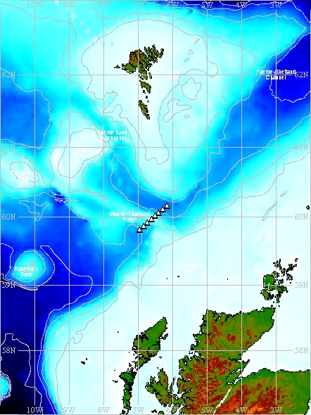
(Map produced using the GEBCO Digital Atlas)
The black triangles indicate the nominal positions of individual Line PA stations which make up the repeat section. Measurements made along Line PA lie within a box bounded by co-ordinates 59° 49.2' N, 6° 57.0' W at the south west corner and 60° 10.0' N, 6° 9.9' W at the north east corner.
Nominal Fixed Stations details
| Station | Nominal latitude | Nominal longitude | Approx. depth |
|---|---|---|---|
| PA2 | 59° 49.2' N | 6° 57.0' W | 1038 m |
| PA3 * | 59° 52.1' N | 6° 50.0' W | 935 m |
| PA4 | 59° 55.1' N | 6° 43.4' W | 618 m |
| PA5 | 59° 58.1' N | 6° 37.1' W | 330 m |
| PA6 | 60° 1.1' N | 6° 30.5' W | 467 m |
| PA7 | 60° 4.0' N | 6° 23.8' W | 1087 m |
| PA8 | 60° 7.0' N | 6° 16.7' W | 1166 m |
| PA9 ** | 60° 10.0' N | 6° 9.9' W | 1219 m |
* Station only occupied on cruise PO300_2 in 2003
** Station only occupied on cruise D321B in 2007
Related Fixed Station activities are detailed in Appendix 2
Fixed Station Information
| Station Name | DML Line PA Station PA7 |
| Category | Offshore location |
| Latitude | 60° 4.00' N |
| Longitude | 6° 23.80' W |
| Water depth below MSL | 1087.0 m |
DML Station PA7
Station PA7 is one of several fixed CTD stations established by scientists at Dunstaffnage Marine Laboratory (DML), which together form Line PA. Station PA7 is situated on the Wyville Thomson Ridge and was first occupied on cruise PO300_2 in 2003 and again, in 2004, during cruise D321B.
Related Fixed Station activities are detailed in Appendix 3
BODC Quality Control Flags
The following single character qualifying flags may be associated with one or more individual parameters with a data cycle:
| Flag | Description |
|---|---|
| Blank | Unqualified |
| < | Below detection limit |
| > | In excess of quoted value |
| A | Taxonomic flag for affinis (aff.) |
| B | Beginning of CTD Down/Up Cast |
| C | Taxonomic flag for confer (cf.) |
| D | Thermometric depth |
| E | End of CTD Down/Up Cast |
| G | Non-taxonomic biological characteristic uncertainty |
| H | Extrapolated value |
| I | Taxonomic flag for single species (sp.) |
| K | Improbable value - unknown quality control source |
| L | Improbable value - originator's quality control |
| M | Improbable value - BODC quality control |
| N | Null value |
| O | Improbable value - user quality control |
| P | Trace/calm |
| Q | Indeterminate |
| R | Replacement value |
| S | Estimated value |
| T | Interpolated value |
| U | Uncalibrated |
| W | Control value |
| X | Excessive difference |
SeaDataNet Quality Control Flags
The following single character qualifying flags may be associated with one or more individual parameters with a data cycle:
| Flag | Description |
|---|---|
| 0 | no quality control |
| 1 | good value |
| 2 | probably good value |
| 3 | probably bad value |
| 4 | bad value |
| 5 | changed value |
| 6 | value below detection |
| 7 | value in excess |
| 8 | interpolated value |
| 9 | missing value |
| A | value phenomenon uncertain |
| B | nominal value |
| Q | value below limit of quantification |
Appendix 1: Wyville Thomson Ridge
Related series for this Fixed Station are presented in the table below. Further information can be found by following the appropriate links.
If you are interested in these series, please be aware we offer a multiple file download service. Should your credentials be insufficient for automatic download, the service also offers a referral to our Enquiries Officer who may be able to negotiate access.
| Series Identifier | Data Category | Start date/time | Start position | Cruise |
|---|---|---|---|---|
| 626899 | CTD or STD cast | 2003-04-20 03:13:00 | 59.9437 N, 8.1305 W | FRV Scotia 0703S |
| 626906 | CTD or STD cast | 2003-04-20 04:00:00 | 59.955 N, 8.1967 W | FRV Scotia 0703S |
| 626918 | CTD or STD cast | 2003-04-20 04:47:00 | 59.9663 N, 8.2597 W | FRV Scotia 0703S |
| 626931 | CTD or STD cast | 2003-04-20 05:32:00 | 59.9792 N, 8.3025 W | FRV Scotia 0703S |
| 626943 | CTD or STD cast | 2003-04-20 07:12:00 | 59.9972 N, 8.3603 W | FRV Scotia 0703S |
| 626955 | CTD or STD cast | 2003-04-20 08:24:00 | 59.9943 N, 8.376 W | FRV Scotia 0703S |
| 626967 | CTD or STD cast | 2003-04-20 09:36:00 | 60.001 N, 8.4297 W | FRV Scotia 0703S |
| 626979 | CTD or STD cast | 2003-04-20 10:43:00 | 60.0072 N, 8.4618 W | FRV Scotia 0703S |
| 626980 | CTD or STD cast | 2003-04-20 11:42:00 | 60.011 N, 8.4943 W | FRV Scotia 0703S |
| 626992 | CTD or STD cast | 2003-04-20 12:53:00 | 60.0182 N, 8.5375 W | FRV Scotia 0703S |
| 627006 | CTD or STD cast | 2003-04-20 13:43:00 | 60.0252 N, 8.5728 W | FRV Scotia 0703S |
| 627018 | CTD or STD cast | 2003-04-20 14:42:00 | 60.0407 N, 8.6428 W | FRV Scotia 0703S |
| 627031 | CTD or STD cast | 2003-04-20 15:35:00 | 60.0655 N, 8.5973 W | FRV Scotia 0703S |
| 627043 | CTD or STD cast | 2003-04-20 16:22:00 | 60.0853 N, 8.5553 W | FRV Scotia 0703S |
| 627055 | CTD or STD cast | 2003-04-20 17:12:00 | 60.106 N, 8.5227 W | FRV Scotia 0703S |
| 627067 | CTD or STD cast | 2003-04-20 18:05:00 | 60.118 N, 8.5005 W | FRV Scotia 0703S |
| 627079 | CTD or STD cast | 2003-04-20 19:01:00 | 60.1338 N, 8.4765 W | FRV Scotia 0703S |
| 627080 | CTD or STD cast | 2003-04-20 20:03:00 | 60.1508 N, 8.4478 W | FRV Scotia 0703S |
| 627092 | CTD or STD cast | 2003-04-20 21:09:00 | 60.162 N, 8.4237 W | FRV Scotia 0703S |
| 627111 | CTD or STD cast | 2003-04-20 22:38:00 | 60.1813 N, 8.4073 W | FRV Scotia 0703S |
| 627123 | CTD or STD cast | 2003-04-20 23:51:00 | 60.2005 N, 8.384 W | FRV Scotia 0703S |
| 627135 | CTD or STD cast | 2003-04-21 01:50:00 | 60.2177 N, 8.3677 W | FRV Scotia 0703S |
| 627147 | CTD or STD cast | 2003-04-21 02:12:00 | 60.24 N, 8.3435 W | FRV Scotia 0703S |
| 627159 | CTD or STD cast | 2003-04-21 03:19:00 | 60.2483 N, 8.3317 W | FRV Scotia 0703S |
| 627160 | CTD or STD cast | 2003-04-21 04:25:00 | 60.2598 N, 8.3207 W | FRV Scotia 0703S |
| 627172 | CTD or STD cast | 2003-04-21 05:31:00 | 60.278 N, 8.3028 W | FRV Scotia 0703S |
| 627184 | CTD or STD cast | 2003-04-21 06:25:00 | 60.294 N, 8.2863 W | FRV Scotia 0703S |
| 627196 | CTD or STD cast | 2003-04-21 07:31:00 | 60.315 N, 8.2677 W | FRV Scotia 0703S |
| 627203 | CTD or STD cast | 2003-04-21 09:03:00 | 60.355 N, 8.2293 W | FRV Scotia 0703S |
| 627215 | CTD or STD cast | 2003-04-21 12:37:00 | 60.3955 N, 9.1597 W | FRV Scotia 0703S |
| 627227 | CTD or STD cast | 2003-04-21 13:34:00 | 60.3458 N, 9.1788 W | FRV Scotia 0703S |
| 627239 | CTD or STD cast | 2003-04-21 14:27:00 | 60.3262 N, 9.1877 W | FRV Scotia 0703S |
| 627240 | CTD or STD cast | 2003-04-21 15:30:00 | 60.3102 N, 9.1952 W | FRV Scotia 0703S |
| 627252 | CTD or STD cast | 2003-04-21 16:44:00 | 60.2928 N, 9.205 W | FRV Scotia 0703S |
| 627264 | CTD or STD cast | 2003-04-21 18:33:00 | 60.2698 N, 9.2032 W | FRV Scotia 0703S |
| 627276 | CTD or STD cast | 2003-04-21 20:19:00 | 60.2537 N, 9.2555 W | FRV Scotia 0703S |
| 627288 | CTD or STD cast | 2003-04-21 22:18:00 | 60.2255 N, 9.3653 W | FRV Scotia 0703S |
| 627307 | CTD or STD cast | 2003-04-22 00:26:00 | 60.2002 N, 9.4585 W | FRV Scotia 0703S |
| 627319 | CTD or STD cast | 2003-04-22 02:23:00 | 60.1778 N, 9.5617 W | FRV Scotia 0703S |
| 627320 | CTD or STD cast | 2003-04-22 04:06:00 | 60.1458 N, 9.6712 W | FRV Scotia 0703S |
| 627332 | CTD or STD cast | 2003-04-22 05:44:00 | 60.1642 N, 9.8153 W | FRV Scotia 0703S |
| 627344 | CTD or STD cast | 2003-04-22 07:10:00 | 60.2138 N, 9.8157 W | FRV Scotia 0703S |
| 627356 | CTD or STD cast | 2003-04-22 08:34:00 | 60.2682 N, 9.8153 W | FRV Scotia 0703S |
| 627368 | CTD or STD cast | 2003-04-22 09:53:00 | 60.321 N, 9.8142 W | FRV Scotia 0703S |
| 627381 | CTD or STD cast | 2003-04-22 11:16:00 | 60.352 N, 9.8158 W | FRV Scotia 0703S |
| 627393 | CTD or STD cast | 2003-04-22 12:31:00 | 60.375 N, 9.8165 W | FRV Scotia 0703S |
| 627400 | CTD or STD cast | 2003-04-22 13:51:00 | 60.4305 N, 9.814 W | FRV Scotia 0703S |
| 627412 | CTD or STD cast | 2003-04-22 14:48:00 | 60.447 N, 9.817 W | FRV Scotia 0703S |
| 627424 | CTD or STD cast | 2003-04-22 19:35:00 | 60.4005 N, 8.5665 W | FRV Scotia 0703S |
| 627436 | CTD or STD cast | 2003-04-22 20:45:00 | 60.3623 N, 8.4053 W | FRV Scotia 0703S |
| 627448 | CTD or STD cast | 2003-04-22 22:02:00 | 60.3165 N, 8.2693 W | FRV Scotia 0703S |
| 627461 | CTD or STD cast | 2003-04-22 23:22:00 | 60.2787 N, 8.1137 W | FRV Scotia 0703S |
| 627473 | CTD or STD cast | 2003-04-23 00:35:00 | 60.2423 N, 7.954 W | FRV Scotia 0703S |
| 627485 | CTD or STD cast | 2003-04-23 01:45:00 | 60.203 N, 7.815 W | FRV Scotia 0703S |
| 627497 | CTD or STD cast | 2003-04-23 02:47:00 | 60.1907 N, 7.7233 W | FRV Scotia 0703S |
| 627504 | CTD or STD cast | 2003-04-23 03:52:00 | 60.1787 N, 7.6223 W | FRV Scotia 0703S |
| 627516 | CTD or STD cast | 2003-04-23 05:10:00 | 60.1357 N, 7.4828 W | FRV Scotia 0703S |
| 627528 | CTD or STD cast | 2003-04-23 06:25:00 | 60.0737 N, 7.3432 W | FRV Scotia 0703S |
| 627541 | CTD or STD cast | 2003-04-23 07:37:00 | 60.0397 N, 7.1873 W | FRV Scotia 0703S |
| 627553 | CTD or STD cast | 2003-04-23 08:56:00 | 60.0032 N, 6.9805 W | FRV Scotia 0703S |
| 627565 | CTD or STD cast | 2003-04-23 09:48:00 | 59.9945 N, 6.8983 W | FRV Scotia 0703S |
| 627577 | CTD or STD cast | 2003-04-23 10:52:00 | 59.9922 N, 6.7567 W | FRV Scotia 0703S |
| 627589 | CTD or STD cast | 2003-04-23 12:04:00 | 59.9608 N, 6.5878 W | FRV Scotia 0703S |
| 627590 | CTD or STD cast | 2003-04-23 13:08:00 | 59.9173 N, 6.438 W | FRV Scotia 0703S |
| 627608 | CTD or STD cast | 2003-04-23 14:06:00 | 59.8697 N, 6.3035 W | FRV Scotia 0703S |
| 627621 | CTD or STD cast | 2003-04-23 15:08:00 | 59.8132 N, 6.2093 W | FRV Scotia 0703S |
| 627633 | CTD or STD cast | 2003-04-23 16:05:00 | 59.7498 N, 6.1825 W | FRV Scotia 0703S |
| 627645 | CTD or STD cast | 2003-04-25 18:19:00 | 60.0425 N, 6.5553 W | FRV Scotia 0703S |
| 627657 | CTD or STD cast | 2003-04-25 19:25:00 | 60.049 N, 6.6513 W | FRV Scotia 0703S |
| 627669 | CTD or STD cast | 2003-04-25 20:33:00 | 60.0512 N, 6.7603 W | FRV Scotia 0703S |
| 627670 | CTD or STD cast | 2003-04-25 21:48:00 | 60.044 N, 6.87 W | FRV Scotia 0703S |
| 627682 | CTD or STD cast | 2003-04-25 23:07:00 | 60.076 N, 6.9695 W | FRV Scotia 0703S |
| 627694 | CTD or STD cast | 2003-04-26 00:23:00 | 60.0898 N, 7.0712 W | FRV Scotia 0703S |
| 627701 | CTD or STD cast | 2003-04-26 01:35:00 | 60.1097 N, 7.1728 W | FRV Scotia 0703S |
| 627713 | CTD or STD cast | 2003-04-26 02:50:00 | 60.1325 N, 7.2478 W | FRV Scotia 0703S |
| 627725 | CTD or STD cast | 2003-04-26 04:10:00 | 60.152 N, 7.3427 W | FRV Scotia 0703S |
| 627737 | CTD or STD cast | 2003-04-26 05:43:00 | 60.1725 N, 7.4442 W | FRV Scotia 0703S |
| 627749 | CTD or STD cast | 2003-04-26 06:45:00 | 60.1993 N, 7.513 W | FRV Scotia 0703S |
| 627750 | CTD or STD cast | 2003-04-26 07:50:00 | 60.2232 N, 7.6033 W | FRV Scotia 0703S |
| 627762 | CTD or STD cast | 2003-04-26 12:44:00 | 60.4238 N, 9.2537 W | FRV Scotia 0703S |
| 627774 | CTD or STD cast | 2003-04-26 13:17:00 | 60.4063 N, 9.3028 W | FRV Scotia 0703S |
| 627786 | CTD or STD cast | 2003-04-26 13:52:00 | 60.3992 N, 9.3275 W | FRV Scotia 0703S |
| 627798 | CTD or STD cast | 2003-04-26 14:35:00 | 60.3898 N, 9.3512 W | FRV Scotia 0703S |
| 627805 | CTD or STD cast | 2003-04-26 15:39:00 | 60.3755 N, 9.3962 W | FRV Scotia 0703S |
| 627817 | CTD or STD cast | 2003-04-26 16:51:00 | 60.3558 N, 9.447 W | FRV Scotia 0703S |
| 627829 | CTD or STD cast | 2003-04-26 18:16:00 | 60.3848 N, 9.573 W | FRV Scotia 0703S |
| 627830 | CTD or STD cast | 2003-04-26 19:27:00 | 60.3998 N, 9.6482 W | FRV Scotia 0703S |
| 627842 | CTD or STD cast | 2003-04-26 20:29:00 | 60.4075 N, 9.6843 W | FRV Scotia 0703S |
| 627854 | CTD or STD cast | 2003-04-26 21:30:00 | 60.415 N, 9.7168 W | FRV Scotia 0703S |
| 627866 | CTD or STD cast | 2003-04-26 22:31:00 | 60.4253 N, 9.7618 W | FRV Scotia 0703S |
| 627878 | CTD or STD cast | 2003-04-26 23:29:00 | 60.454 N, 9.764 W | FRV Scotia 0703S |
| 627891 | CTD or STD cast | 2003-04-27 00:16:00 | 60.457 N, 9.6963 W | FRV Scotia 0703S |
| 627909 | CTD or STD cast | 2003-04-27 01:11:00 | 60.4598 N, 9.6118 W | FRV Scotia 0703S |
| 627910 | CTD or STD cast | 2003-04-27 03:13:00 | 60.4667 N, 9.5283 W | FRV Scotia 0703S |
| 627922 | CTD or STD cast | 2003-04-27 03:53:00 | 60.4702 N, 9.4908 W | FRV Scotia 0703S |
| 627934 | CTD or STD cast | 2003-04-27 04:37:00 | 60.4723 N, 9.4308 W | FRV Scotia 0703S |
| 627946 | CTD or STD cast | 2003-04-27 05:30:00 | 60.482 N, 9.2873 W | FRV Scotia 0703S |
| 627958 | CTD or STD cast | 2003-04-27 06:48:00 | 60.4942 N, 9.0017 W | FRV Scotia 0703S |
| 627971 | CTD or STD cast | 2003-04-27 07:50:00 | 60.4307 N, 8.8362 W | FRV Scotia 0703S |
| 627983 | CTD or STD cast | 2003-04-27 08:39:00 | 60.3682 N, 8.8527 W | FRV Scotia 0703S |
| 627995 | CTD or STD cast | 2003-04-27 09:18:00 | 60.3363 N, 8.8638 W | FRV Scotia 0703S |
| 628009 | CTD or STD cast | 2003-04-27 10:05:00 | 60.3005 N, 8.8818 W | FRV Scotia 0703S |
| 628010 | CTD or STD cast | 2003-04-27 11:11:00 | 60.267 N, 8.8903 W | FRV Scotia 0703S |
| 628022 | CTD or STD cast | 2003-04-27 12:05:00 | 60.2442 N, 8.9063 W | FRV Scotia 0703S |
| 628034 | CTD or STD cast | 2003-04-27 13:22:00 | 60.224 N, 8.9128 W | FRV Scotia 0703S |
| 628046 | CTD or STD cast | 2003-04-27 14:11:00 | 60.2093 N, 8.9155 W | FRV Scotia 0703S |
| 628058 | CTD or STD cast | 2003-04-27 15:02:00 | 60.179 N, 8.9295 W | FRV Scotia 0703S |
| 628071 | CTD or STD cast | 2003-04-27 16:28:00 | 60.2712 N, 9.2132 W | FRV Scotia 0703S |
| 628083 | CTD or STD cast | 2003-04-27 17:52:00 | 60.282 N, 9.1667 W | FRV Scotia 0703S |
| 628095 | CTD or STD cast | 2003-04-27 19:28:00 | 60.292 N, 9.1312 W | FRV Scotia 0703S |
| 628102 | CTD or STD cast | 2003-04-27 20:31:00 | 60.2993 N, 9.0868 W | FRV Scotia 0703S |
| 628114 | CTD or STD cast | 2003-04-27 21:23:00 | 60.3128 N, 9.0282 W | FRV Scotia 0703S |
| 628126 | CTD or STD cast | 2003-04-27 22:48:00 | 60.2952 N, 9.018 W | FRV Scotia 0703S |
| 628138 | CTD or STD cast | 2003-04-27 23:32:00 | 60.2785 N, 9.0142 W | FRV Scotia 0703S |
| 628151 | CTD or STD cast | 2003-04-28 00:23:00 | 60.2622 N, 9.01 W | FRV Scotia 0703S |
| 628163 | CTD or STD cast | 2003-04-28 01:25:00 | 60.2495 N, 9.0072 W | FRV Scotia 0703S |
| 628175 | CTD or STD cast | 2003-04-28 02:38:00 | 60.2302 N, 8.9903 W | FRV Scotia 0703S |
| 628187 | CTD or STD cast | 2003-04-28 03:45:00 | 60.2085 N, 8.9617 W | FRV Scotia 0703S |
| 628199 | CTD or STD cast | 2003-04-28 04:52:00 | 60.148 N, 8.8472 W | FRV Scotia 0703S |
| 628206 | CTD or STD cast | 2003-04-28 05:37:00 | 60.1795 N, 8.763 W | FRV Scotia 0703S |
| 628218 | CTD or STD cast | 2003-04-28 06:26:00 | 60.1982 N, 8.6935 W | FRV Scotia 0703S |
| 628231 | CTD or STD cast | 2003-04-28 07:23:00 | 60.223 N, 8.6103 W | FRV Scotia 0703S |
| 628243 | CTD or STD cast | 2003-04-28 08:18:00 | 60.264 N, 8.5852 W | FRV Scotia 0703S |
| 628255 | CTD or STD cast | 2003-04-28 09:16:00 | 60.3072 N, 8.5597 W | FRV Scotia 0703S |
| 628267 | CTD or STD cast | 2003-04-28 10:05:00 | 60.3422 N, 8.5412 W | FRV Scotia 0703S |
| 628279 | CTD or STD cast | 2003-04-28 10:53:00 | 60.3888 N, 8.5135 W | FRV Scotia 0703S |
| 628280 | CTD or STD cast | 2003-04-28 14:35:00 | 60.1753 N, 9.5588 W | FRV Scotia 0703S |
| 628292 | CTD or STD cast | 2003-04-28 15:40:00 | 60.1757 N, 9.4652 W | FRV Scotia 0703S |
| 628311 | CTD or STD cast | 2003-04-28 16:49:00 | 60.1782 N, 9.375 W | FRV Scotia 0703S |
| 628323 | CTD or STD cast | 2003-04-28 18:09:00 | 60.1783 N, 9.2328 W | FRV Scotia 0703S |
| 628335 | CTD or STD cast | 2003-04-28 19:34:00 | 60.1775 N, 9.0308 W | FRV Scotia 0703S |
| 628347 | CTD or STD cast | 2003-04-28 21:55:00 | 60.1493 N, 8.452 W | FRV Scotia 0703S |
| 845261 | CTD or STD cast | 2003-07-27 18:51:00 | 59.71597 N, 7.15278 W | Poseidon PO300_2 |
| 845273 | CTD or STD cast | 2003-07-28 20:39:00 | 59.8202 N, 6.95063 W | Poseidon PO300_2 |
| 845285 | CTD or STD cast | 2003-07-28 22:15:00 | 59.86838 N, 6.83345 W | Poseidon PO300_2 |
| 845297 | CTD or STD cast | 2003-07-29 00:00:00 | 59.91805 N, 6.7241 W | Poseidon PO300_2 |
| 845304 | CTD or STD cast | 2003-07-29 01:29:00 | 59.96848 N, 6.61855 W | Poseidon PO300_2 |
| 845316 | CTD or STD cast | 2003-07-29 02:52:00 | 60.01832 N, 6.5087 W | Poseidon PO300_2 |
| 845328 | CTD or STD cast | 2003-07-29 20:02:00 | 60.168 N, 6.16677 W | Poseidon PO300_2 |
| 845341 | CTD or STD cast | 2003-07-29 22:13:00 | 60.11595 N, 6.27883 W | Poseidon PO300_2 |
| 845353 | CTD or STD cast | 2003-07-30 00:03:00 | 60.06682 N, 6.39653 W | Poseidon PO300_2 |
| 845365 | CTD or STD cast | 2003-07-30 01:24:00 | 60.0279 N, 6.48653 W | Poseidon PO300_2 |
| 845377 | CTD or STD cast | 2003-07-30 02:49:00 | 60.05145 N, 6.63285 W | Poseidon PO300_2 |
| 845389 | CTD or STD cast | 2003-07-30 09:46:00 | 60.10163 N, 6.09385 W | Poseidon PO300_2 |
| 845390 | CTD or STD cast | 2003-07-30 16:22:00 | 60.0508 N, 6.81967 W | Poseidon PO300_2 |
| 845408 | CTD or STD cast | 2003-07-30 17:41:00 | 60.08522 N, 6.93385 W | Poseidon PO300_2 |
| 845421 | CTD or STD cast | 2003-07-30 19:03:00 | 60.11207 N, 7.06995 W | Poseidon PO300_2 |
| 845433 | CTD or STD cast | 2003-07-30 20:52:00 | 60.14212 N, 7.23043 W | Poseidon PO300_2 |
| 845445 | CTD or STD cast | 2003-07-30 22:24:00 | 60.1744 N, 7.38717 W | Poseidon PO300_2 |
| 845457 | CTD or STD cast | 2003-07-30 23:43:00 | 60.20735 N, 7.53108 W | Poseidon PO300_2 |
| 845469 | CTD or STD cast | 2003-07-31 00:56:00 | 60.2355 N, 7.6598 W | Poseidon PO300_2 |
| 845470 | CTD or STD cast | 2003-07-31 02:13:00 | 60.26925 N, 7.80108 W | Poseidon PO300_2 |
| 845482 | CTD or STD cast | 2003-07-31 03:32:00 | 60.2949 N, 7.9169 W | Poseidon PO300_2 |
| 845494 | CTD or STD cast | 2003-08-01 05:17:00 | 60.1811 N, 7.73665 W | Poseidon PO300_2 |
| 1014447 | Currents -subsurface Eulerian | 2003-08-01 09:30:00 | 60.183 N, 7.7338 W | Poseidon PO300_2 |
| 1014435 | Currents -subsurface Eulerian | 2003-09-28 19:30:00 | 60.23917 N, 8.86833 W | FRV Scotia 1403S |
| 896598 | CTD or STD cast | 2005-10-14 09:31:00 | 60.2159 N, 6.19836 W | RRS Charles Darwin CD176 |
| 896605 | CTD or STD cast | 2005-10-14 11:20:00 | 60.21326 N, 6.20296 W | RRS Charles Darwin CD176 |
| 896617 | CTD or STD cast | 2005-10-14 13:53:00 | 60.29942 N, 6.11356 W | RRS Charles Darwin CD176 |
| 896629 | CTD or STD cast | 2005-10-14 23:59:00 | 60.08054 N, 6.32135 W | RRS Charles Darwin CD176 |
| 896630 | CTD or STD cast | 2005-10-15 02:04:00 | 60.0144 N, 6.34818 W | RRS Charles Darwin CD176 |
| 896642 | CTD or STD cast | 2005-10-15 23:45:00 | 60.33948 N, 9.0409 W | RRS Charles Darwin CD176 |
| 896654 | CTD or STD cast | 2005-10-16 01:45:00 | 60.28932 N, 9.02996 W | RRS Charles Darwin CD176 |
| 896666 | CTD or STD cast | 2005-10-16 03:38:00 | 60.27818 N, 9.01476 W | RRS Charles Darwin CD176 |
| 896678 | CTD or STD cast | 2005-10-16 05:30:00 | 60.26256 N, 9.0105 W | RRS Charles Darwin CD176 |
| 896691 | CTD or STD cast | 2005-10-16 07:55:00 | 60.24946 N, 9.00726 W | RRS Charles Darwin CD176 |
| 896709 | CTD or STD cast | 2005-10-16 10:51:00 | 60.22923 N, 8.99213 W | RRS Charles Darwin CD176 |
| 896710 | CTD or STD cast | 2005-10-16 12:46:00 | 60.18908 N, 8.96128 W | RRS Charles Darwin CD176 |
| 1014459 | Currents -subsurface Eulerian | 2005-10-16 15:30:00 | 60.23942 N, 8.86997 W | RRS Charles Darwin CD176 |
| 896722 | CTD or STD cast | 2005-10-16 21:16:00 | 60.4263 N, 8.24386 W | RRS Charles Darwin CD176 |
| 1014460 | Currents -subsurface Eulerian | 2006-05-07 08:02:41 | 60.2495 N, 8.91 W | FRV Scotia 0706S |
| 776793 | CTD or STD cast | 2006-10-28 04:24:44 | 60.34267 N, 8.99217 W | RRS Discovery D312 |
| 776800 | CTD or STD cast | 2006-10-28 05:48:17 | 60.3115 N, 8.94867 W | RRS Discovery D312 |
| 776812 | CTD or STD cast | 2006-10-28 07:45:53 | 60.298 N, 8.932 W | RRS Discovery D312 |
| 776824 | CTD or STD cast | 2006-10-28 09:33:32 | 60.26583 N, 8.91833 W | RRS Discovery D312 |
| 776836 | CTD or STD cast | 2006-10-28 12:38:43 | 60.284 N, 8.92417 W | RRS Discovery D312 |
| 776848 | CTD or STD cast | 2006-10-28 14:06:35 | 60.255 N, 8.91567 W | RRS Discovery D312 |
| 1014472 | Currents -subsurface Eulerian | 2006-10-28 16:33:08 | 60.25 N, 8.9165 W | RRS Discovery D312 |
| 776861 | CTD or STD cast | 2006-10-28 16:54:10 | 60.2365 N, 8.91617 W | RRS Discovery D312 |
| 776873 | CTD or STD cast | 2006-10-28 19:32:14 | 60.22717 N, 8.917 W | RRS Discovery D312 |
| 847673 | CTD or STD cast | 2007-09-02 15:12:51 | 60.24698 N, 9.00905 W | RRS Discovery D321B |
| 1014484 | Currents -subsurface Eulerian | 2007-09-02 17:45:00 | 60.24517 N, 9.01267 W | RRS Discovery D321B |
| 847685 | CTD or STD cast | 2007-09-02 22:31:15 | 60.54961 N, 8.1944 W | RRS Discovery D321B |
| 847697 | CTD or STD cast | 2007-09-03 03:34:58 | 60.59987 N, 8.28802 W | RRS Discovery D321B |
| 847704 | CTD or STD cast | 2007-09-03 04:13:23 | 60.60423 N, 8.28849 W | RRS Discovery D321B |
| 847901 | CTD or STD cast | 2007-09-04 08:08:33 | 60.59981 N, 8.1302 W | RRS Discovery D321B |
| 847716 | CTD or STD cast | 2007-09-04 17:39:37 | 60.57216 N, 7.48264 W | RRS Discovery D321B |
| 847728 | CTD or STD cast | 2007-09-05 00:40:48 | 60.3882 N, 7.25541 W | RRS Discovery D321B |
| 847741 | CTD or STD cast | 2007-09-05 08:32:53 | 60.26364 N, 6.84096 W | RRS Discovery D321B |
| 847753 | CTD or STD cast | 2007-09-07 01:58:25 | 60.16545 N, 6.16475 W | RRS Discovery D321B |
| 847765 | CTD or STD cast | 2007-09-07 04:20:22 | 60.11849 N, 6.27459 W | RRS Discovery D321B |
| 847789 | CTD or STD cast | 2007-09-07 08:13:00 | 60.0348 N, 6.41938 W | RRS Discovery D321B |
| 847790 | CTD or STD cast | 2007-09-07 11:03:00 | 60.01627 N, 6.50561 W | RRS Discovery D321B |
| 847808 | CTD or STD cast | 2007-09-07 12:27:38 | 59.96778 N, 6.62012 W | RRS Discovery D321B |
| 847821 | CTD or STD cast | 2007-09-07 13:46:35 | 59.91902 N, 6.73161 W | RRS Discovery D321B |
| 847833 | CTD or STD cast | 2007-09-07 15:43:43 | 59.8233 N, 6.95149 W | RRS Discovery D321B |
| 1623433 | Currents -subsurface Eulerian | 2008-05-18 20:55:00 | 60.24517 N, 9.01267 W | FRV Scotia 0508S |
| 1623445 | Currents -subsurface Eulerian | 2008-06-18 00:10:00 | 60.24517 N, 9.01267 W | FRV Scotia 0508S |
| 1623457 | Currents -subsurface Eulerian | 2008-07-18 00:10:00 | 60.24517 N, 9.01267 W | FRV Scotia 0508S |
| 1623469 | Currents -subsurface Eulerian | 2008-08-18 00:10:00 | 60.24517 N, 9.01267 W | FRV Scotia 0508S |
| 1623470 | Currents -subsurface Eulerian | 2008-09-18 00:10:00 | 60.24517 N, 9.01267 W | FRV Scotia 0508S |
| 1623482 | Currents -subsurface Eulerian | 2008-10-18 00:10:00 | 60.24517 N, 9.01267 W | FRV Scotia 0508S |
| 1623494 | Currents -subsurface Eulerian | 2008-11-18 00:10:00 | 60.24517 N, 9.01267 W | FRV Scotia 0508S |
| 1623501 | Currents -subsurface Eulerian | 2008-12-18 00:10:00 | 60.24517 N, 9.01267 W | FRV Scotia 0508S |
| 1623513 | Currents -subsurface Eulerian | 2009-01-18 00:10:00 | 60.24517 N, 9.01267 W | FRV Scotia 0508S |
| 1623525 | Currents -subsurface Eulerian | 2009-02-18 00:10:00 | 60.24517 N, 9.01267 W | FRV Scotia 0508S |
| 1623537 | Currents -subsurface Eulerian | 2009-03-18 00:10:00 | 60.24517 N, 9.01267 W | FRV Scotia 0508S |
| 1623549 | Currents -subsurface Eulerian | 2009-04-18 00:10:00 | 60.24517 N, 9.01267 W | FRV Scotia 0508S |
| 1623550 | Currents -subsurface Eulerian | 2009-05-18 00:10:00 | 60.24517 N, 9.01267 W | FRV Scotia 0508S |
| 954401 | CTD or STD cast | 2009-06-21 16:07:50 | 60.20665 N, 8.95695 W | RRS Discovery D340A |
| 954413 | CTD or STD cast | 2009-06-21 17:20:27 | 60.2186 N, 8.97383 W | RRS Discovery D340A |
| 954425 | CTD or STD cast | 2009-06-21 18:21:56 | 60.22989 N, 8.99 W | RRS Discovery D340A |
| 954437 | CTD or STD cast | 2009-06-21 19:58:18 | 60.24991 N, 9.00529 W | RRS Discovery D340A |
| 954449 | CTD or STD cast | 2009-06-21 21:11:56 | 60.26127 N, 9.00824 W | RRS Discovery D340A |
| 954450 | CTD or STD cast | 2009-06-21 22:24:23 | 60.2783 N, 9.01223 W | RRS Discovery D340A |
| 954462 | CTD or STD cast | 2009-06-22 00:03:16 | 60.29325 N, 9.01763 W | RRS Discovery D340A |
| 954474 | CTD or STD cast | 2009-06-22 01:20:57 | 60.33382 N, 9.02786 W | RRS Discovery D340A |
| 954486 | CTD or STD cast | 2009-06-22 03:05:44 | 60.38812 N, 9.03649 W | RRS Discovery D340A |
| 954498 | CTD or STD cast | 2009-06-22 04:49:33 | 60.26206 N, 9.00946 W | RRS Discovery D340A |
| 954505 | CTD or STD cast | 2009-06-22 07:35:09 | 60.23988 N, 8.99759 W | RRS Discovery D340A |
| 954517 | CTD or STD cast | 2009-06-22 10:33:56 | 60.29171 N, 9.12969 W | RRS Discovery D340A |
| 954529 | CTD or STD cast | 2009-06-22 11:52:23 | 60.26806 N, 9.20608 W | RRS Discovery D340A |
| 954530 | CTD or STD cast | 2009-06-22 14:20:10 | 60.24754 N, 9.28554 W | RRS Discovery D340A |
| 954542 | CTD or STD cast | 2009-06-22 16:21:18 | 60.22707 N, 9.36207 W | RRS Discovery D340A |
| 954554 | CTD or STD cast | 2009-06-22 18:09:24 | 60.19218 N, 9.49349 W | RRS Discovery D340A |
| 954566 | CTD or STD cast | 2009-06-22 20:32:12 | 60.35444 N, 9.44191 W | RRS Discovery D340A |
| 954578 | CTD or STD cast | 2009-06-22 22:40:14 | 60.31848 N, 9.35247 W | RRS Discovery D340A |
| 954591 | CTD or STD cast | 2009-06-23 00:28:59 | 60.29054 N, 9.27921 W | RRS Discovery D340A |
| 954609 | CTD or STD cast | 2009-06-23 02:46:20 | 60.25009 N, 9.15898 W | RRS Discovery D340A |
| 954610 | CTD or STD cast | 2009-06-23 04:30:26 | 60.22413 N, 9.07486 W | RRS Discovery D340A |
| 954622 | CTD or STD cast | 2009-06-23 07:27:28 | 60.25882 N, 9.12326 W | RRS Discovery D340A |
| 954634 | CTD or STD cast | 2009-06-23 09:32:52 | 60.24685 N, 9.06133 W | RRS Discovery D340A |
| 954646 | CTD or STD cast | 2009-06-23 11:27:59 | 60.24213 N, 8.91099 W | RRS Discovery D340A |
| 954658 | CTD or STD cast | 2009-06-23 13:21:42 | 60.24256 N, 8.81257 W | RRS Discovery D340A |
| 954671 | CTD or STD cast | 2009-06-23 15:41:22 | 60.24605 N, 9.0164 W | RRS Discovery D340A |
| 1639619 | Currents -subsurface Eulerian | 2011-05-12 08:30:00 | 60.2475 N, 8.92166 W | FRV Scotia 0511S |
| 1639620 | Currents -subsurface Eulerian | 2011-06-12 00:00:00 | 60.2475 N, 8.92166 W | FRV Scotia 0511S |
| 1639632 | Currents -subsurface Eulerian | 2011-07-12 00:00:00 | 60.2475 N, 8.92166 W | FRV Scotia 0511S |
| 1639644 | Currents -subsurface Eulerian | 2011-08-12 00:00:00 | 60.2475 N, 8.92166 W | FRV Scotia 0511S |
| 1639656 | Currents -subsurface Eulerian | 2011-09-12 00:00:00 | 60.2475 N, 8.92166 W | FRV Scotia 0511S |
| 1639668 | Currents -subsurface Eulerian | 2011-10-12 00:00:00 | 60.2475 N, 8.92166 W | FRV Scotia 0511S |
| 1639681 | Currents -subsurface Eulerian | 2011-11-12 00:00:00 | 60.2475 N, 8.92166 W | FRV Scotia 0511S |
| 1639693 | Currents -subsurface Eulerian | 2011-12-12 00:00:00 | 60.2475 N, 8.92166 W | FRV Scotia 0511S |
| 1639700 | Currents -subsurface Eulerian | 2012-01-12 00:14:59 | 60.2475 N, 8.92166 W | FRV Scotia 0511S |
| 1639712 | Currents -subsurface Eulerian | 2012-02-12 00:14:59 | 60.2475 N, 8.92166 W | FRV Scotia 0511S |
| 1639724 | Currents -subsurface Eulerian | 2012-03-12 00:14:59 | 60.2475 N, 8.92166 W | FRV Scotia 0511S |
| 1639736 | Currents -subsurface Eulerian | 2012-04-12 00:14:59 | 60.2475 N, 8.92166 W | FRV Scotia 0511S |
| 1639748 | Currents -subsurface Eulerian | 2012-05-12 00:14:59 | 60.2475 N, 8.92166 W | FRV Scotia 0511S |
| 1203661 | CTD or STD cast | 2012-08-06 18:18:00 | 60.38833 N, 8.51243 W | RRS Discovery D379 |
| 1203673 | CTD or STD cast | 2012-08-06 19:59:00 | 60.34098 N, 8.53872 W | RRS Discovery D379 |
| 1203685 | CTD or STD cast | 2012-08-06 21:42:00 | 60.308 N, 8.55094 W | RRS Discovery D379 |
| 1203697 | CTD or STD cast | 2012-08-06 23:36:00 | 60.26418 N, 8.57292 W | RRS Discovery D379 |
| 1203704 | CTD or STD cast | 2012-08-07 01:02:00 | 60.21951 N, 8.60904 W | RRS Discovery D379 |
| 1203716 | CTD or STD cast | 2012-08-07 03:03:00 | 60.19408 N, 8.69338 W | RRS Discovery D379 |
| 1203728 | CTD or STD cast | 2012-08-07 04:39:00 | 60.17799 N, 8.762 W | RRS Discovery D379 |
| 1203741 | CTD or STD cast | 2012-08-07 06:05:00 | 60.14615 N, 8.84574 W | RRS Discovery D379 |
| 1203753 | CTD or STD cast | 2012-08-07 07:43:00 | 60.20816 N, 8.96124 W | RRS Discovery D379 |
| 1203765 | CTD or STD cast | 2012-08-07 09:21:00 | 60.25059 N, 8.90955 W | RRS Discovery D379 |
| 1203777 | CTD or STD cast | 2012-08-07 12:28:00 | 60.23005 N, 8.98769 W | RRS Discovery D379 |
| 1203789 | CTD or STD cast | 2012-08-07 14:08:00 | 60.24506 N, 9.00491 W | RRS Discovery D379 |
| 1639515 | Currents -subsurface Eulerian | 2012-08-07 17:00:00 | 60.24996 N, 8.90965 W | RRS Discovery D379 |
| 1203790 | CTD or STD cast | 2012-08-07 17:35:00 | 60.26122 N, 9.00856 W | RRS Discovery D379 |
| 1640669 | Hydrography time series at depth | 2012-08-07 18:14:58 | 60.24996 N, 8.90965 W | RRS Discovery D379 |
| 1203808 | CTD or STD cast | 2012-08-07 19:24:00 | 60.27805 N, 9.01287 W | RRS Discovery D379 |
| 1203821 | CTD or STD cast | 2012-08-07 20:47:00 | 60.2944 N, 9.01618 W | RRS Discovery D379 |
| 1203833 | CTD or STD cast | 2012-08-07 22:06:00 | 60.31188 N, 9.02541 W | RRS Discovery D379 |
| 1639527 | Currents -subsurface Eulerian | 2012-09-07 00:14:59 | 60.24996 N, 8.90965 W | RRS Discovery D379 |
| 1639539 | Currents -subsurface Eulerian | 2012-10-07 00:14:59 | 60.24996 N, 8.90965 W | RRS Discovery D379 |
| 1639540 | Currents -subsurface Eulerian | 2012-11-07 00:14:59 | 60.24996 N, 8.90965 W | RRS Discovery D379 |
| 1639552 | Currents -subsurface Eulerian | 2012-12-07 00:14:59 | 60.24996 N, 8.90965 W | RRS Discovery D379 |
| 1639564 | Currents -subsurface Eulerian | 2013-01-07 00:14:59 | 60.24996 N, 8.90965 W | RRS Discovery D379 |
| 1639576 | Currents -subsurface Eulerian | 2013-02-07 00:14:59 | 60.24996 N, 8.90965 W | RRS Discovery D379 |
| 1639588 | Currents -subsurface Eulerian | 2013-03-07 00:14:59 | 60.24996 N, 8.90965 W | RRS Discovery D379 |
| 1639607 | Currents -subsurface Eulerian | 2013-04-07 00:14:59 | 60.24996 N, 8.90965 W | RRS Discovery D379 |
| 1219964 | CTD or STD cast | 2013-05-08 10:50:00 | 60.2078 N, 8.9611 W | RRS James Cook JC086 |
| 1219976 | CTD or STD cast | 2013-05-08 12:27:08 | 60.23 N, 8.99 W | RRS James Cook JC086 |
| 2101073 | Water sample data | 2013-05-08 13:06:30 | 60.4375 N, 9.09222 W | RRS James Cook JC086 |
| 1219988 | CTD or STD cast | 2013-05-08 14:45:52 | 60.2558 N, 9.0073 W | RRS James Cook JC086 |
| 2101085 | Water sample data | 2013-05-08 15:17:30 | 60.34611 N, 9.12111 W | RRS James Cook JC086 |
| 2101687 | Water sample data | 2013-05-08 15:17:30 | 60.34611 N, 9.12111 W | RRS James Cook JC086 |
| 1220001 | CTD or STD cast | 2013-05-08 16:38:43 | 60.2611 N, 9.008 W | RRS James Cook JC086 |
| 2101097 | Water sample data | 2013-05-08 17:15:00 | 60.435 N, 9.13389 W | RRS James Cook JC086 |
| 2101699 | Water sample data | 2013-05-08 17:15:00 | 60.435 N, 9.13389 W | RRS James Cook JC086 |
| 1220013 | CTD or STD cast | 2013-05-08 18:38:04 | 60.277 N, 9.0131 W | RRS James Cook JC086 |
| 2101104 | Water sample data | 2013-05-08 19:07:00 | 60.43833 N, 9.2175 W | RRS James Cook JC086 |
| 2101706 | Water sample data | 2013-05-08 19:07:00 | 60.43833 N, 9.2175 W | RRS James Cook JC086 |
| 1220025 | CTD or STD cast | 2013-05-08 20:22:12 | 60.295 N, 9.0161 W | RRS James Cook JC086 |
Appendix 2: DML Line PA
Related series for this Fixed Station are presented in the table below. Further information can be found by following the appropriate links.
If you are interested in these series, please be aware we offer a multiple file download service. Should your credentials be insufficient for automatic download, the service also offers a referral to our Enquiries Officer who may be able to negotiate access.
| Series Identifier | Data Category | Start date/time | Start position | Cruise |
|---|---|---|---|---|
| 845273 | CTD or STD cast | 2003-07-28 20:39:00 | 59.8202 N, 6.95063 W | Poseidon PO300_2 |
| 845285 | CTD or STD cast | 2003-07-28 22:15:00 | 59.86838 N, 6.83345 W | Poseidon PO300_2 |
| 845297 | CTD or STD cast | 2003-07-29 00:00:00 | 59.91805 N, 6.7241 W | Poseidon PO300_2 |
| 845304 | CTD or STD cast | 2003-07-29 01:29:00 | 59.96848 N, 6.61855 W | Poseidon PO300_2 |
| 845316 | CTD or STD cast | 2003-07-29 02:52:00 | 60.01832 N, 6.5087 W | Poseidon PO300_2 |
| 845341 | CTD or STD cast | 2003-07-29 22:13:00 | 60.11595 N, 6.27883 W | Poseidon PO300_2 |
| 845353 | CTD or STD cast | 2003-07-30 00:03:00 | 60.06682 N, 6.39653 W | Poseidon PO300_2 |
| 847753 | CTD or STD cast | 2007-09-07 01:58:25 | 60.16545 N, 6.16475 W | RRS Discovery D321B |
| 847765 | CTD or STD cast | 2007-09-07 04:20:22 | 60.11849 N, 6.27459 W | RRS Discovery D321B |
| 847790 | CTD or STD cast | 2007-09-07 11:03:00 | 60.01627 N, 6.50561 W | RRS Discovery D321B |
| 847808 | CTD or STD cast | 2007-09-07 12:27:38 | 59.96778 N, 6.62012 W | RRS Discovery D321B |
| 847821 | CTD or STD cast | 2007-09-07 13:46:35 | 59.91902 N, 6.73161 W | RRS Discovery D321B |
| 847833 | CTD or STD cast | 2007-09-07 15:43:43 | 59.8233 N, 6.95149 W | RRS Discovery D321B |
Appendix 3: DML Line PA Station PA7
Related series for this Fixed Station are presented in the table below. Further information can be found by following the appropriate links.
If you are interested in these series, please be aware we offer a multiple file download service. Should your credentials be insufficient for automatic download, the service also offers a referral to our Enquiries Officer who may be able to negotiate access.
| Series Identifier | Data Category | Start date/time | Start position | Cruise |
|---|---|---|---|---|
| 845353 | CTD or STD cast | 2003-07-30 00:03:00 | 60.06682 N, 6.39653 W | Poseidon PO300_2 |
