Search the data

Bottom pressure recorders

The map below indicates sites where bottom pressure recorder data are available.

Most of these bottom pressure records have been collected as part of the Antarctic Circumpolar Current Levels by Altimetry and Island Measurements (ACCLAIM) programme, conducted by the Proudman Oceanographic Laboratory (POL). Find out more about ACCLAIM from the POL ACCLAIM web pages.

Data files and site history information may be accessed via the following inventories

Click on the Access the data to download the data and View the documentation to view the site history information. The data are available in BODC request format (ASCII) and WOCE netCDF format. Sites are ordered by latitude and longitude.

Click on the map dots to advance to the appropriate inventory entry.
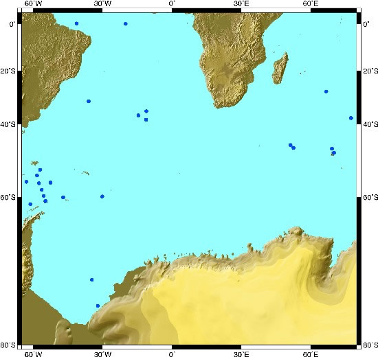
Bottom pressure recorder sites
Bottom pressure recorder sites ©
PAVASAS FP1 Marfrio Tristan da Cunha — A Tristan da Cunha — B Tristan da Cunha — C Falkland-Signy Transect — Position 1 Falkland-Signy Transect — Position 2 Falkland-Signy Transect — Position 3 Drake Passage North — ND1 Drake Passage North — ND2 Drake Passage North North South — NNS Drake Passage Central — CD Myrtle Drake Passage South — SD2 Drake Passage South — SD1 CH1 CH2 MS2 ID2 Crozet CK2 Kerguelen Is. Amsterdam Is.

Some of these data are also included within the International Association for the Physical Sciences of the Oceans (IAPSO)/Permanent Service for Mean Sea Level (PSMSL) Pelagic Tidal Constants data set. The 'IAPSO' column below indicates their reference code.

Indian Ocean

These data are deep sea pressure records (depths shown are approximate) not coastal stations. The site names are just convenient labels.

Station Latitude 
Longitude
Depth Date NetCDF ASCII Document IAPSO
Amsterdam 37 54.10S
77 34.16E
310m 1984-07-261985-02-15 Download b0529952.zip Download amst.zip Amsterdam Island site history 3.2.9
37 54.10S
77 37.16E
178m 1986-03-201986-12-22 Download b0530037.zip 3.2.10
37 54.10S
77 37.16E
165m 1986-12-231987-12-21 Download b0529964.zip 3.2.11
37 54.10S
77 37.16E
180m 1987-12-221988-12-19 Download b0529976.zip 3.2.12
37 54.00S
77 35.00E
470m 1986-03-201987-12-21 Download b0529988.zip 3.2.17
37 54.00S 
77 35.00E
460m 1987-12-231988-12-19 Download b0530049.zip 3.2.18
37 54.26S 
77 34.83E
350m 1991-05-111992-01-31 Download b0530001.zip
37 53.00S 
77 35.00E
350m 1992-05-011993-07-11 Download b0530013.zip
37 54.20S 
77 34.72E
350m 1993-07-111994-10-23 Download b0530025.zip
Kerguelen 48 51.50S 
70 10.00E
105m 1986-02-271986-12-17 Download b0530234.zip Download kerg.zip Kerguelen Island site history 3.2.13
48 51.50S 
70 10.00E
106m 1986-12-181987-12-18 Download b0530246.zip 3.2.14
48 51.50S 
70 10.00E
106m 1987-12-181988-12-15 Download b0530258.zip 3.2.15
48 51.60S 
70 10.80E
103m 1988-12-161989-12-31 Download b0530271.zip
47 39.60S 
69 21.69E
185m 1993-07-061994-10-20 Download b0530283.zip
ID2 28 19.18S 
66 49.68E
3650m 1984-08-01 — 1985-02 Download b0530222.zip Download id2.zip Station ID2 site history 3.2.16
Crozet 46 23.95S 
51 56.52E
160m 1993-06-301994-10-09 Download b0530062.zip Download crozet.zip Crozet site history
CK2 46 52.26S 
52 28.29E
3600m 1993-03-091994-03-03 Download b0530050.zip Download ck2.zip Crozet-Kerguelen Line West Station (CK2) site history 3.2.19/20/21

Drake Passage, Scotia Sea and Weddell Sea

Station  Latitude 
Longitude
 Depth  Date  NetCDF ASCII Document  IAPSO
FS1 53 32.39S
 57 00.90W 
2803m 1988-11-271989-11-11 Download b0530129.zip Download fs1.zip Falkland-Signy Transect North Station (FS1) site history 1.4.5/6/7 
53 32.39S
57 01.89W 
2800m  1989-11-111990-11-21 Download b0530130.zip 1.4.8/9/10 
53 30.70S
56 58.80W 
2800m 1990-11-231992-01-09 Download b0530142.zip 1.4.11/12/13 
53 31.40S
57 01.90W 
2800m 1992-01-121992-11-15  Download b0530154.zip
FS2  56 41.97S
52 32.26W 
3150m  1988-11-281989-11-12 Download b0530166.zip Download fs2.zip Falkland-Signy Transect Centre Station (FS2) site history 4.2.8/9/10
56 39.93S
52 28.55W 
2861m  1989-11-121990-11-23 Download b0530178.zip 4.2.11/12/13 
FS3 60 02.23S
47 05.99W 
2180m  1989-11-141990-11-24 Download b0530191.zip Download fs3.zip Falkland-Signy Transect South Station (FS3) site history 4.2.14/15/16 
60 03.10S
47 05.10W 
2010m  1990-11-251992-01-07 Download b0530209.zip 4.2.17/18/19 
60 03.10S
47 10.00W 
2267m  1992-01-071992-11-23 Download b0530210.zip
ND2 54 56.54S
58 23.59W 
1010m  1992-11-091993-11-22 Download b0530326.zip Download nd2_1992.zip Drake Passage North ND2/9294 site history 1.4.29/30/31
ND2 54 56.58S
58 23.51W 
1007m  1993-11-221994-11-15 Download b0530338.zip
ND2 54 56.65S 
58 23.11W
1052m 1994-11-161996-11-14 Download b0530086.zip Download nd2_1994.zip Drake Passage North ND2/9496 site history
ND2 54 56.64S
58 23.02W
1050m 1996-12-031997-12-19 Download b0581640.zip Download nd2_1996.zip Drake Passage North ND2/9697 site history
ND1  56 29.45S
62 59.13W 
3925m  1991-12-221992-11-06 Download b0530314.zip Download nd1.zip Drake Passage North ND1/9192 site history 4.2.21
NNS 56 50.15S
 57 30.09W 
2096m 1995-11-261996-11-17  Download b0530098.zip Download nns.zip Drake Passage North North South NNS/9596 site history
CD  58 21.76S
56 21.28W
3776m  1994-11-191996-11-18  Download b0530074.zip Download cd.zip Drake Passage Central CD/9496 site history
Myrtle  59 43.69S 
55 29.50W
3690m 1992-11-131996-11-19 Download b0530302.zip Download myrtle.zip Myrtle site history 4.2.30/31 
SD2  60 50.99S
54 42.88W 
1020m  1992-11-131993-11-26 Download b0530375.zip Download sd2_1992.zip Drake Passage South SD2/9294 site history 4.2.27/28/29
SD2 60 50.98S
54 42.84W
1020m 1993-11-271994-11-21 Download b0530387.zip
SD2  60 51.01S
54 43.01W
1040m  1994-11-211996-11-20 Download b0530105.zip Download sd2_1994.zip Drake Passage South SD2/9496 site history
SD2 60 50.96S
54 43.36W
1107m 1996-11-201997-12-30 Download b0581652.zip Download sd2_1996.zip Drake Passage South SD2/9697 site history
SD1  61 28.43S
61 17.43W 
3946m  1991-12-231992-11-07 Download b0530363.zip Download sd1.zip Drake Passage South SD1/9192 site history 4.2.24 
Weddell CH1  59 52.04S
30 06.04W
2823m 1998-01-181999-04-08 Download b0581664.zip Download ch1.zip ROPEX Weddell Station CH1 site history
Weddell CH2  73 41.53S
34 36.95W
2826m 1998-01-211999-02-17 Download b0581676.zip Download ch2.zip ROPEX Weddell Station CH2 site history
Weddell MS2  76 35.09S
32 00.40W
389m 1998-02-101999-02-21 Download b0581688.zip Download ms2.zip ROPEX Weddell Station MS2 site history

South and Central Atlantic

These data are deep sea pressure records (depths shown are approximate) not coastal stations. The site names are just convenient labels.

Station Latitude
Longitude
Depth Date NetCDF ASCII Document IAPSO
FP1 00 00.00N 
20 01.00W 
2700m 1983-02-031984-09-24 Download b0530117.zip Download fp1.zip Station FP1 site history 1.3.16
Tristan-A  35 31.00S
11 02.00W
4080m  1985-11-061986-10-03 Download b0530399.zip Download tris_a.zip Tristan da Cunha - A site history 1.4.14/15/16
35 31.00S
11 02.00W 
4082m  1986-10-041987-09-26 Download b0530406.zip 1.4.17/18 
35 32.00S
11 00.00W 
4090m  1987-09-271988-10-08 Download b0530418.zip 1.4.19 
Tristan-B  37 00.00S
14 29.00W 
3505m  1986-10-021987-09-25 Download b0530431.zip Download tris_b.zip Tristan da Cunha - B site history 1.4.20/21/22
Tristan-C  38 31.00S
11 09.00W 
3435m  1985-11-021986-09-30 Download b0530443.zip Download tris_c.zip Tristan da Cunha - C site history 1.4.23/24/25
38 31.00S
11 09.00W 
3120m  1986-10-211987-09-24 Download b0530455.zip 1.4/26/27/28
Marfrio 31 59.9 S
36 00.7 W 
2604m  1995-05-011996-05-05 Download b0530295.zip Download marfrio.zip Marfrio site history
PAVASAS  0 13.96N
41 12.62W 
104m  1987-07-231987-08-29 Download b0530351.zip Download pavasas.zip PAVASAS site history

In addition to the bottom pressure data collected by POL, other bottom pressure data have been collected by the USA. These are described in the table below.

The instruments used were Sea-Bird SBE-16 SEACATs. The data files contain the following parameters

  • Temperature (°C)
  • Pressure (db)
  • Conductivity (mmho cm-1)
  • Salinity (psu)

These data are available from the Oregon State University (OSU) Buoy Group web site.

Latitude  Longitude Sea floor depth (m) Date Serial no.
44 06.70S  146 13.08E  994.6  1991-10-081994-01-01 707
44 07.18S  146 13.13E  1024.9  1994-01-021996-01-06 717 
65 33.68S  139 51.15E  1010.2 1994-01-161996-03-15 718 
34 35.33S  017 48.39E  985.0  1992-03-271993-11-10 709 
34 35.30S  017 48.34E  991.5 1992-03-271996-02-05 710 
34 35.26S 017 48.36E  989.4  1993-11-101997-08-03 719 
42 59.52S  002 20.25E  744.6  1992-06-011994-03-10 711 
42 59.57S  002 20.31E  808.8  1992-06-011996-02-10 712 
54 20.61S  003 01.43E  971.9  1992-04-021994-03-20 713 
54 20.61S  003 01.43E  964.1  1992-04-021996-02-13 714 
70 08.11S  002 38.50E  979.0  1992-03-131993-12-26 715 
70 07.89S  002 36.89E  889.2  1993-12-261997-01-21 722
Permanent Service for Mean Sea Level (PSMSL). Global Sea Level Observing System (GLOSS). World Ocean Circulation Experiment (WOCE). Climate Variability and Predictability (CLIVAR).