Search the data

South Pacific data

The map and inventory below indicate sites where sea level data are available.

Data files and site history information may be accessed via the inventory. Click on the Access the data to download the data and View the documentation to view the site history and related information. Sites are ordered by latitude and longitude.

Click on the map dots to advance to the appropriate inventory entry.
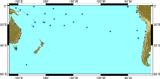
South Pacific sea level sites
South Pacific sea level sites ©
Macquarie Is. Moturiki Hobart Spring Bay Fort Denison Bundaberg Townsville Lombrum Rabaul Honiara Nauru Noumea Port Vila Funafuti Lautoka Suva Nukualofa Pago Pago Kanton Penrhyn Rarotonga Papeete Nuku Hiva Rikitea Easter Is. Baltra Santa Cruz Lobos de Afuera Callao Arica San Felix Caldera Juan Fernandez Valparaiso

South Pacific sea level data inventory

GLOSS no. Site name Position Duration NetCDF ASCII Document
130 Macquarie Is. 54 29.0S 
158 58.0E
1993 — 1999 Download g0130.zip Download g130.zip Flinders University of South Australia data access conditions Macquarie Island (Australia) site history
9018 Hobart 42 53.0S 
147 20.0E
1985, 1987 — 1995 Download w9018.zip Download w9018.zip Hobart (Australia) Site History Hobart (Australia) data quality assessment
56 Spring Bay 42 33.0S 
147 56.0E
1991 — 2001 Download g0056.zip Download g056.zip Flinders University of South Australia data access conditions Spring Bay (Tasmania, Australia) site history
9022 Moturiki 37 39.0S 
176 11.0E
1995 Download w9022.zip Download w9022.zip Moturiki (New Zealand) site history
176 Juan Fernandez-A 33 37.3S 
078 50.0W
1977 — 1979, 1981 — 1984 Download g0176a.zip Download g176a.zip Juan Fernandez-A (Chile) site history
176 Juan Fernandez-B 33 37.3S
078 50.0W
1985 — 1988 Download g0176b.zip Download g176b.zip Juan Fernandez-B (Chile) site history
176 Juan Fernandez-C 33 37.3S 
078 50.0W
1990 — 1998 Download g0176c.zip Download g176c.zip Juan Fernandez-C (Chile) site history
175 Valparaiso-A 33 02.0S 
071 38.0W
1944 — 1974, 1977 — 1978 Download g0175a.zip Download g175a.zip Valparaiso-A (Chile) site history
175 Valparaiso-B 33 02.0S 
071 38.0W
1982 — 1998 Download g0175b.zip Download g175b.zip Valparaiso-B (Chile) site history
57 Fort Denison 33 51.0S 
151 14.0E
1985 — 1987, 1996 — 1998 Download g0057.zip Download g057.zip Flinders University of South Australia data access conditions Fort Denison (Sydney, Australia) site history Fort Denison (Sydney, Australia) data quality assessment
137 Easter Island-A (Pascua) 27 09.0S 
109 27.0W
1957 — 1958 Download g0137a.zip Download g137a.zip Isla da Pascua-A (Chile) site history
137 Easter Island-B (Pascua) 27 09.0S 
109 27.0W
1962 — 1963 Download g0137b.zip Download g137b.zip Isla da Pascua-B (Chile) site history
137 Easter Island-D (Pascua) 27 09.0S 
109 27.0W
1977 — 1984 Download g0137d.zip Download g137d.zip Isla da Pascua-D (Chile) site history
137 Easter Island-E (Pascua) 27 09.0S 
109 27.0W
1985 — 1998 Download g0137e.zip Download g137e.zip Isla da Pascua-E (Chile) site history
9002 Caldera 27 04.0S
070 50.0W
1980 — 1998 Download w9002.zip Download w9002.zip Cladera (Chile) site history
177 San Felix 26 17.0S
80 08.0W
1987 — 1993, 1996 — 1997 Download g0177.zip Download g177.zip San Felix (Chile) site history
59 Bundaberg 24 50.0S 
152 21.0E
1997 — 1998 Download g0059.zip Download g059.zip Flinders University of South Australia data access conditions Bundaberg (Burnett Heads, Australia) site history
138 Rikitea 23 07.5S 
134 57.2W
1969 — 1998 Download g0138.zip Download g138.zip Rikitea (Mangareva Islands, French Polynesia) site history
123 Noumea,Nouvelle Caledonie 22 17.5S 
166 26.2E
1967 — 1998 Download g0123.zip Download g123.zip Noumea (New Caledonia) site history
9051 Nuku'alofa 21 08.0S 
175 10.0W
1990 — 2001 Download w9051.zip Download w9051.zip Flinders University of South Australia data access conditions Nuku'alofa (Tonga) site history
139 Rarotonga 21 12.4S 
159 46.5W
1977 — 2001 Download g0139.zip Download g139.zip Flinders University of South Australia data access conditions Rarotonga (Cook Islands) site history
60 Townsville 19 15.0S 
146 50.0E
1985 — 1998 Download g0060.zip Download g060.zip Flinders University of South Australia data access conditions Townsville (Australia) site history
9001 Arica 18 28.0S 
070 20.0W
1982 — 1998 Download w9001.zip Download w9001.zip Arica (Chile) site history
122 Suva 18 07.9S 
178 25.6E
1972 — 1998, 2000 — 2001 Download g0122.zip Download g122.zip Flinders University of South Australia data access conditions Suva (Fiji) site history
9108 Lautoka, Fiji 17 36.0S
177 26.0E
1992 — 2001 Download w9108.zip Download w9108.zip Lautoka (Fiji) site history
140 Papeete - A 17 31.5S 
149 34.0W
1969 — 1975 Download g0140a.zip Download g140a.zip Papeete-A (French Polynesia) site history
140 Papeete - B 17 31.5S 
149 34.0W
1975 — 1998 Download g0140b.zip Download g140b.zip Papeete-B (French Polynesia) site history
9026 Port Vila-A 17 46.0S 
168 18.0E
1977 — 1982 Download w9026a.zip Download w9026a.zip Port Vila-A (Vanuatu) site history
9026 Port Vila-B 17 46.0S 
168 18.0E
1993 — 2001 Download w9026b.zip Download w9026b.zip Flinders University of South Australia data access conditions Port Vila-B (Vanuatu) site history
144 Pago Pago, Samoa 14 17.0S 
170 41.0W
1948 — 2000 Download g0144.zip Download g144.zip Pago Pago (Samoa) site history Comment on station position
173 Callao-A 12 03.0S 
077 09.0W
1950 — 1965 Download g0173a.zip Download g173a.zip Callao-A (Peru) site history
173 Callao-B 12 03.0S 
077 09.0W
1970 — 1994 Download g0173b.zip Download g173b.zip Callao-B (Peru) site history
66 Honiara 09 25.5S 
159 57.4E
1974 — 2001 Download g0066.zip Download g066.zip Flinders University of South Australia data access conditions Honiara (Solomon Islands) site history
143 Penrhyn 08 58.6S 
158 03.2W
1977 — 1998 Download g0143.zip Download g143.zip Penrhyn (Cook Islands) site history
142 Nuku Hiva, Marquesas Is. 08 55.8S
140 04.9W
1982, 1986 — 1997 Download g0142.zip Download g142.zip Nuku Hiva (Marquesas Islands, French Polynesia) site history
121 Funafuti, Ellice Is. 08 31.5S 
179 11.7E
1977 — 2001 Download g0121.zip Download g121.zip Flinders University of South Australia data access conditions Funafuti (Tuvalu) site history
9048 Lobos De Afuera 06 56.0S 
080 43.0W
1982 — 1994 Download w9048.zip Download w9048.zip Lobos de Afuera (Peru) site history
65 Rabaul 04 12.0S 
152 10.5E
1966 — 1971, 1974 — 1997 Download g0065.zip Download g065.zip Rabaul (Papua New Guinea) site history
145 Kanton-A, Phoenix Is. 02 48.6S 
171 43.1W
1949 — 1967 Download g0145a.zip Download g145a.zip Kanton-A (Kiribati) site history
145 Kanton-B, Phoenix Is. 02 48.6S 
171 43.1W
1972 — 1998 Download g0145b.zip Download g145b.zip Kanton-B (Kiribati) site history
9027 Lombrum 02 02.0S 
147 22.0E
1994 — 1998 Download w9027.zip Download w9027.zip Flinders University of South Australia data access conditions Lombrum (Papua New Guinea) site history
9053 Santa Cruz, Galapagos Is. 00 45.2S 
090 18.7W
1978 — 1998 Download w9053.zip Download w9053.zip Santa Cruz (Galapagos Islands, Ecuador) site history
169 Baltra-A, Galapagos Is. 00 26.1S 
090 17.1W
1968 — 1977 Download g0169a.zip Download g169a.zip Baltra-A (Galapagos Islands) site history
169 Baltra-B, Galapagos Is. 00 26.1S 
090 17.1W
1985 — 1998 Download g0169b.zip Download g169b.zip Baltra-B (Galapagos Islands) site history
114 Nauru 00 31.7S 
166 54.3E
1974 — 2001 Download g0114.zip Download g114.zip Flinders University of South Australia data access conditions Nauru site history
Permanent Service for Mean Sea Level (PSMSL). Global Sea Level Observing System (GLOSS). World Ocean Circulation Experiment (WOCE). Climate Variability and Predictability (CLIVAR).