Metadata Report for BODC Series Reference Number 1804935
Metadata Summary
Problem Reports
Data Access Policy
Narrative Documents
Project Information
Data Activity or Cruise Information
Fixed Station Information
BODC Quality Flags
SeaDataNet Quality Flags
Metadata Summary
Data Description |
|||||||||||||||||||||||||||||||||||||
|
|||||||||||||||||||||||||||||||||||||
Data Identifiers |
|||||||||||||||||||||||||||||||||||||
|
|||||||||||||||||||||||||||||||||||||
Time Co-ordinates(UT) |
|||||||||||||||||||||||||||||||||||||
|
|||||||||||||||||||||||||||||||||||||
Spatial Co-ordinates | |||||||||||||||||||||||||||||||||||||
|
|||||||||||||||||||||||||||||||||||||
Parameters |
|||||||||||||||||||||||||||||||||||||
|
|||||||||||||||||||||||||||||||||||||
|
|||||||||||||||||||||||||||||||||||||
Problem Reports
No Problem Report Found in the Database
Data Access Policy
Open Data
These data have no specific confidentiality restrictions for users. However, users must acknowledge data sources as it is not ethical to publish data without proper attribution. Any publication or other output resulting from usage of the data should include an acknowledgment.
If the Information Provider does not provide a specific attribution statement, or if you are using Information from several Information Providers and multiple attributions are not practical in your product or application, you may consider using the following:
"Contains public sector information licensed under the Open Government Licence v1.0."
Narrative Documents
Aanderaa Recording Current Meter Model 9/11
The RCM 9/11 is a family of single-point Doppler recording current meters with different casing options to allow working at depths of up to 300 (RCM 9 LW), 2000 (RCM 9 IW) or 6000 (RCM 11) metres. The recording unit is 51.3 cm or 59.5 cm high (RCM 9 and RCM 11, respectively) with a diameter of 12.8 cm.
The RCM is most commonly deployed in an in-line mooring configuration. As it operates under a tilt up to 35° from vertical, it has a variety of in-line mooring applications by use of surface buoy or sub surface buoy. The instrument is installed in a mooring frame that allows easy installation and removal of the instrument without disassembly of the mooring line. The instrument can also be used for direct reading of the various parameters. This is conveniently done due to its compact design, low drag force and easy handling. Data can be stored internally and read after retrieval or be read in real time on deck by use of the profiling cable.
Meter comprises:
- A Vane Plate (3681) to stabilise the meter during profiling (stops spin).
- Stainless Steel Mooring Frame made to facilitate easy installation and removal of the instrument by use of two knobs.
- Doppler Current Sensor (Current speed sensor) - Range of speed recorded 0-300 cm s-1 with a 0.3 cm s-1 resolution.
- Hall Effect Compass - Direction recorded with 0.35 ° resolution, 5 ° for 0.15 ° tilt and 7.5 ° for 15-35 ° tilt.
- Thermistor (Temperature sensor) - With selectable wide, low, high and Arctic ranges. Standard range -2.70 to 21.77 °C, accuracy 0.05 °C, resolution 0.1% of selected range, 63% response time (12 sec).
- Inductive Cell Conductivity Sensor (optional) - Range 0 to 75 mS cm-1, standard resolution 0.002 mS cm-1.
- Pressure Sensor (optional) - Silicon piezoresistive bridge, standard range 0 to 3500 kPa, resolution 0.1% of range.
- Turbidity Sensor (optional) - Optical back-scatter sensor, resolution 0.1% of full scale, (RCM 11 depth capacity 2000 m).
- Oxygen Sensor (optional) - Oxygen optode, range 0 to 500 µM, resolution < 1µM, response time 60 sec, depth capacity 6000 m.
- Data storage units DSU 2990 and 2990E are standard data storage devices for Aanderaa data collecting instruments.
A built-in quartz clock allows the time of the first measurement to be recorded in the DSU. The measuring system is made up of a self-balancing bridge with sequential measurement of 10 channels and solid state memory. Channel 1 is a fixed reference reading for control purposes and data identification. Channels 2 and 3 represent measurement of current speed and direction. The direction is found by the use of measurements along two orthogonal axis and linking them to true north by use of an internal compass reading. The instrument can operate continuously or in eight intervals from 1 to 120 minutes. At 60-minute recording interval the operating time is more than two years. The current speed and direction are averaged over the measuring interval. Channels 4, 5 and 6 represent temperature, conductivity and pressure respectively.
Further information can be found in the manufacturer's instrument specification.
DML Aanderaa RCM current meter data and ADCP Workhorse: Originator's data processing
Summary of DML (formerly SMBA) Standard Procedures for Current Meter Data
Mooring System for Water Depths up to 200m
U shaped mooring i.e. pellet float to pellet line to sub-surface buoy to meter mooring line (with either in-line or A-frame mounting of meters) to anchor weight to ground line to anchor weight to marker buoy tow chain, then line to surface spar marker buoy and to pellet line and floats. The mooring is deployed in the order given and recovered in reverse order. Usually lengths of main wires are: buoy tow line D-15m, buoy tow chain 55m, sometimes buoy line is all chain, (prior to 1977 buoy tow line 2D used without chain), ground wire 2D (but never less than 150m), meter rope (excluding sub-surface buoy bridles and anchor bridles) D-X-3m where D is the depth of water and X is the depth of the sub-surface buoy. Generally X=30m but this may vary depending on the application of the mooring and the requirement for near surface current measurements. The mooring site is chosen by echo sounding to accord with the preset length of instrument line; however occasionally the length of the instrument line is adjusted on station. The site is positioned to an accuracy of 0.5nm using either Decca main chain, Loran or Satellite Navigation (GPS), depending on reception etc.
Data Processing
Speed is integrated over the sampling interval. Direction and, where measured, temperature and pressure, are taken as spot measurements at the end of the sampling interval. Direction is corrected for magnetic variation. Pressure measurements are not corrected for atmospheric pressure.
Parameter values i.e. speed, temperature and pressure are given at times incremented by the sample interval. The time assigned to each parameter is that of the end of the sampling interval. Time values are corrected for clock error should this occur.
Sea floor depths are relative to the instantaneous sea surface i.e. obtained from corrected echo soundings at the time of rig deployment (Matthew's corrections are applied).
Data at the 2nd bin (11 m above bed) from the ADCP's were exported and saved to ASCII files.
Calibrations
Each meter is calibrated against the manufacturer's formulae for direction and Plessey meters are calibrated for temperature; Aanderaa meters use the manufacturer's temperature calibrations. The manufacturer's velocity and pressure calibrations are used.
DML Aanderaa RCM current meters and ADCP Workhorse: BODC data processing
Data from 20 Aanderaa RCM current meters and 5 ADCP Workhorses arrived at BODC in ASCII format.
Only the 2nd bin from the ADCP's arrived at BODC.
Data were reformatted to a standard BODC format. The following table shows how the variables within the data files were mapped to appropriate standard BODC parameter codes:
| Originator's Variable | Units | Description | BODC Parameter Code | Units | Comment |
|---|---|---|---|---|---|
| Northward current velocity | Centimetres per second | Northward current velocity (Eulerian) in the water body by in-situ current meter | LCNSEL01 | Centimetres per second | - |
| Eastward current velocity | Centimetres per second | Eastward current velocity (Eulerian) in the water body by in-situ current meter | LCEWEL01 | Centimetres per second | - |
| Temperature | Degrees Celsius | Temperature of the water body | TEMPPR01 | Degrees Celsius | - |
| Pressure | Decibars | Pressure (measured variable) exerted by the water body by semi-fixed in-situ pressure sensor and corrected to read zero at sea level | PREXPR01 | Decibars | Not present in files from the ADCP. The Originator has advised that the pressure data from Rig#400 are of no value and that the values present are just placeholders in the file. Therefore this channel will not be reformatted. |
| Salinity | psu | Practical salinity of the water body by conductivity cell and computation using UNESCO 1983 algorithm | PSALPR01 | dimensionless | Not present in files from the ADCP. |
The reformatted data were visualised using BODC's in-house visualisation software. Suspect data were marked by adding an appropriate quality control flag, missing data by both setting the data to an appropriate value and setting the quality control flag.
Project Information
No Project Information held for the Series
Data Activity or Cruise Information
Data Activity
| Start Date (yyyy-mm-dd) | 2008-09-25 |
| End Date (yyyy-mm-dd) | 2009-02-24 |
| Organization Undertaking Activity | Scottish Association for Marine Science |
| Country of Organization | United Kingdom |
| Originator's Data Activity Identifier | Tiree#413 |
| Platform Category | subsurface mooring |
Dunstaffnage Marine Laboratory Moored Instrument Rig#413
This rig was deployed in the Tiree Passage at site Y. The deployment forms part of the moored current meter series in the Tiree Passage, from 1981 to present.
| Rig Position | 56° 35.0' N, 05° 35.0' W |
|---|---|
| Time Series Start/Deployment Vessel | 25 Sep 2008 19:00 from RV Calanus |
| Time Series End /Recovery Vessel | 24 Feb 2009 18:00 from RV Calanus |
The instruments formed a U-shaped mooring anchored by two 450kg weights, connected by a 100 metre ground wire. A spar marker buoy was attached to one of the weights, with a recovery line. The instruments, attached to the second weight, were held erect by a sub-surface buoy.
Instruments deployed on the rig
| Height above Sea Bed | Instrument |
|---|---|
| 11 m | Aanderaa current meter (#1389) |
Instruments were fitted with temperature and salinity sensors.
Mooring Rig#413 was also equipped with two SeaBird MicroCATs but no metadata or data has been provided from these instruments.
Fixed Station Information
Fixed Station Information
| Station Name | DML Tiree Passage Mooring |
| Category | Offshore location |
| Latitude | 56° 37.20' N |
| Longitude | 6° 24.00' W |
| Water depth below MSL | 50.0 m |
Tiree Passage Mooring
The Tiree Passage Mooring (also referred to as Y Mooring) is a current meter mooring at 56° 37.2' N, 6° 24.0' W. It has been maintained by the Dunstaffnage Marine Laboratory (DML)/ Scottish Association for Marine Science (SAMS) since 1981. The mooring is serviced approximately 3 times a year. The Tiree Passage Mooring is the longest moored time series of flow and temperature on the NW European continental shelf.
Between 21/05/1993 and 17/09/1997 the mooring included two Aanderaa current meters located 11 m and 22 m above the sea floor except for the period between 09/05/1994 and 15/08/1994 when there was no top current meter. The proportion of good data returned was exceptionally high.
Gaps in the time series are caused by fluctuations in funding, mooring losses and instrument failures (additional gaps in the current time series, usually due to fouling of mechanical current meters).
Although conductivity sensors were fitted to the Aanderaa current meters from 1994 to 1997, the reliability of these sensors over long periods is questionable, and more work needs to be done in cross calibrating the calculated salinity against the salinity of coincident 'Ellett Line/Extended Ellett Line' CTD casts.
It should be noted that some data were submitted to BODC from PML and not DML. This was due the relocation of the Principal Investigator responsible for the data. He subsequently returned to DML.
Summary of Key Activities
| Date | Activity |
|---|---|
| 1981 | Tiree mooring is first deployed |
| June 1981 | Hourly current and temperature measurements using Aanderaa recording current meters (RCMs) recorded at the bottom of the mooring (11 m above the bed) |
| November 1987 | Addition of Aanderaa recording current meters (RCMs) at 22 m above the bed |
| September 1993 | Hourly salinity measurements started to be taken at both depths using Aanderaa conductivity sensors |
| September 1997 | Collection of data at both depths stops |
| Between June 1999 and February 2000 | The mooring was re-deployed |
| May 2002 until the present | Mooring is fitted with RCMs at both 20 m and 45 m above the bed. |
| August 2002 | A Seabird MicroCAT salinity sensor was added at 20 m above bed. |
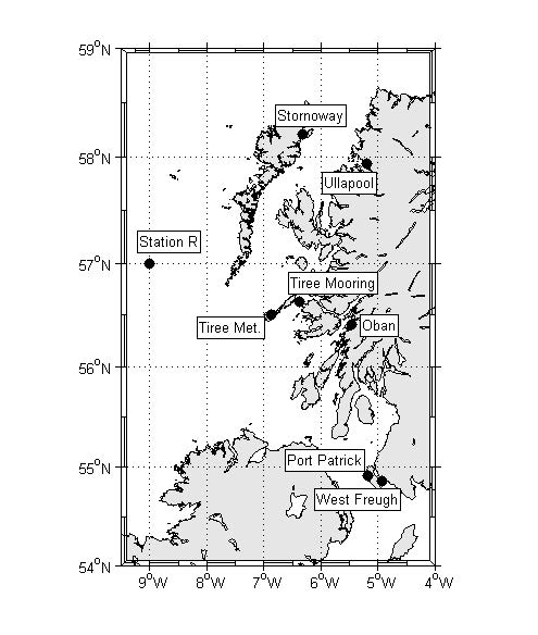
Figure 1: Map showing the locations of the Tiree mooring data time series.
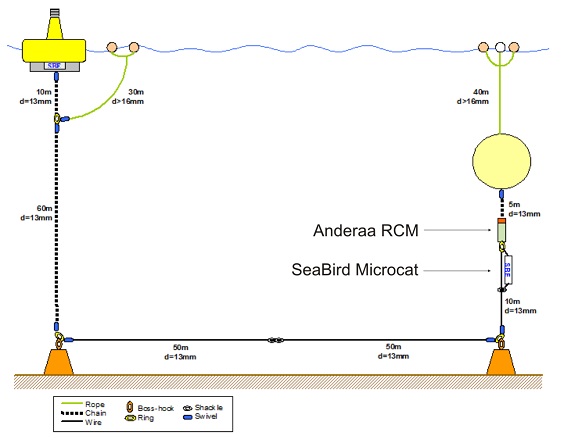
Figure 2: The typcial set up of the Tiree mooring.
References
Inall, M. and Griffiths, C., 2003 The Tiree Passage Time Series: 1981-2003 DEFRA MECN: Tiree Passage
Related Fixed Station activities are detailed in Appendix 1
BODC Quality Control Flags
The following single character qualifying flags may be associated with one or more individual parameters with a data cycle:
| Flag | Description |
|---|---|
| Blank | Unqualified |
| < | Below detection limit |
| > | In excess of quoted value |
| A | Taxonomic flag for affinis (aff.) |
| B | Beginning of CTD Down/Up Cast |
| C | Taxonomic flag for confer (cf.) |
| D | Thermometric depth |
| E | End of CTD Down/Up Cast |
| G | Non-taxonomic biological characteristic uncertainty |
| H | Extrapolated value |
| I | Taxonomic flag for single species (sp.) |
| K | Improbable value - unknown quality control source |
| L | Improbable value - originator's quality control |
| M | Improbable value - BODC quality control |
| N | Null value |
| O | Improbable value - user quality control |
| P | Trace/calm |
| Q | Indeterminate |
| R | Replacement value |
| S | Estimated value |
| T | Interpolated value |
| U | Uncalibrated |
| W | Control value |
| X | Excessive difference |
SeaDataNet Quality Control Flags
The following single character qualifying flags may be associated with one or more individual parameters with a data cycle:
| Flag | Description |
|---|---|
| 0 | no quality control |
| 1 | good value |
| 2 | probably good value |
| 3 | probably bad value |
| 4 | bad value |
| 5 | changed value |
| 6 | value below detection |
| 7 | value in excess |
| 8 | interpolated value |
| 9 | missing value |
| A | value phenomenon uncertain |
| B | nominal value |
| Q | value below limit of quantification |
Appendix 1: DML Tiree Passage Mooring
Related series for this Fixed Station are presented in the table below. Further information can be found by following the appropriate links.
If you are interested in these series, please be aware we offer a multiple file download service. Should your credentials be insufficient for automatic download, the service also offers a referral to our Enquiries Officer who may be able to negotiate access.
| Series Identifier | Data Category | Start date/time | Start position | Cruise |
|---|---|---|---|---|
| 46857 | Currents -subsurface Eulerian | 1983-02-19 11:15:00 | 56.6179 N, 6.3983 W | Not applicable |
| 46869 | Currents -subsurface Eulerian | 1983-05-30 04:15:00 | 56.6266 N, 6.3964 W | Not applicable |
| 60666 | Currents -subsurface Eulerian | 1984-06-26 17:15:00 | 56.6217 N, 6.3967 W | RRS Challenger CH2/84 |
| 249384 | Currents -subsurface Eulerian | 1985-01-28 18:45:06 | 56.63 N, 6.4017 W | RRS Challenger CH1/85 |
| 249396 | Currents -subsurface Eulerian | 1985-05-07 22:00:00 | 56.62 N, 6.4 W | RRS Challenger CH4/85 |
| 60863 | Currents -subsurface Eulerian | 1985-08-19 09:00:00 | 56.625 N, 6.4 W | RRS Challenger CH8/85 |
| 60967 | Currents -subsurface Eulerian | 1985-12-15 17:00:00 | 56.6167 N, 6.4 W | RRS Frederick Russell FR13/85 |
| 61018 | Currents -subsurface Eulerian | 1986-03-21 21:00:00 | 56.619 N, 6.4065 W | RRS Charles Darwin CD10B |
| 61092 | Currents -subsurface Eulerian | 1986-06-14 19:00:00 | 56.6233 N, 6.4033 W | MV Dawn Sky DSK1/86 |
| 249403 | Currents -subsurface Eulerian | 1987-01-09 16:00:06 | 56.6267 N, 6.3867 W | RRS Challenger CH9 |
| 249102 | Currents -subsurface Eulerian | 1987-05-01 13:00:00 | 56.6183 N, 6.4167 W | RRS Challenger CH14 |
| 249187 | Currents -subsurface Eulerian | 1987-09-01 09:00:00 | 56.625 N, 6.405 W | RRS Frederick Russell FR18/87 |
| 249280 | Currents -subsurface Eulerian | 1987-11-29 14:30:06 | 56.63 N, 6.41 W | RRS Challenger CH22 |
| 249292 | Currents -subsurface Eulerian | 1987-11-29 14:30:06 | 56.63 N, 6.41 W | RRS Challenger CH22 |
| 249323 | Currents -subsurface Eulerian | 1988-03-07 12:00:00 | 56.625 N, 6.415 W | RRS Challenger CH25 |
| 249311 | Currents -subsurface Eulerian | 1988-03-07 12:00:06 | 56.625 N, 6.415 W | RRS Challenger CH25 |
| 1803993 | Currents -subsurface Eulerian | 1988-06-08 15:00:00 | 56.62833 N, 6.40333 W | RRS Challenger CH30 |
| 1804007 | Currents -subsurface Eulerian | 1988-06-08 15:00:00 | 56.62833 N, 6.40333 W | RRS Challenger CH30 |
| 1804019 | Currents -subsurface Eulerian | 1989-01-23 16:30:06 | 56.62667 N, 6.39167 W | RRS Discovery D180 |
| 1804020 | Currents -subsurface Eulerian | 1989-01-23 16:30:06 | 56.62667 N, 6.39167 W | RRS Discovery D180 |
| 1804032 | Currents -subsurface Eulerian | 1989-05-05 11:30:06 | 56.61667 N, 6.40333 W | RV Lough Foyle LF1/89 |
| 1804044 | Currents -subsurface Eulerian | 1989-08-04 14:00:00 | 56.61833 N, 6.405 W | RV Lough Foyle LF2/89 |
| 1804056 | Currents -subsurface Eulerian | 1989-08-04 14:00:00 | 56.61833 N, 6.405 W | RV Lough Foyle LF2/89 |
| 508056 | Currents -subsurface Eulerian | 1993-05-21 08:45:00 | 56.6283 N, 6.3967 W | RRS Challenger CH103 |
| 508308 | Currents -subsurface Eulerian | 1993-05-21 08:45:06 | 56.6283 N, 6.3967 W | RRS Challenger CH103 |
| 508068 | Currents -subsurface Eulerian | 1993-09-10 14:30:06 | 56.6255 N, 6.4018 W | RRS Challenger CH105 |
| 508136 | Currents -subsurface Eulerian | 1993-09-10 14:30:06 | 56.6255 N, 6.4018 W | RRS Challenger CH105 |
| 508044 | Currents -subsurface Eulerian | 1994-03-14 19:30:06 | 56.6267 N, 6.4033 W | RRS Challenger CH110 |
| 508081 | Currents -subsurface Eulerian | 1994-05-09 14:45:06 | 56.6283 N, 6.3983 W | RRS Challenger CH112 |
| 508148 | Currents -subsurface Eulerian | 1994-05-09 14:45:06 | 56.6283 N, 6.3983 W | RRS Challenger CH112 |
| 508032 | Currents -subsurface Eulerian | 1994-08-15 21:15:00 | 56.62 N, 6.4017 W | RRS Challenger CH114 |
| 508204 | Currents -subsurface Eulerian | 1994-08-15 21:15:06 | 56.62 N, 6.4017 W | RRS Challenger CH114 |
| 508093 | Currents -subsurface Eulerian | 1994-11-28 13:45:17 | 56.62 N, 6.4 W | RRS Challenger CH116 |
| 508161 | Currents -subsurface Eulerian | 1994-11-28 14:15:05 | 56.62 N, 6.4 W | RRS Challenger CH116 |
| 508228 | Currents -subsurface Eulerian | 1995-04-14 14:45:06 | 56.6183 N, 6.3933 W | RRS Charles Darwin CD92B |
| 508277 | Currents -subsurface Eulerian | 1995-04-14 14:45:06 | 56.6183 N, 6.3933 W | RRS Charles Darwin CD92B |
| 508100 | Currents -subsurface Eulerian | 1995-07-29 14:45:00 | 56.6177 N, 6.4062 W | RRS Challenger CH120 |
| 508173 | Currents -subsurface Eulerian | 1995-07-29 14:45:00 | 56.6177 N, 6.4062 W | RRS Challenger CH120 |
| 508241 | Currents -subsurface Eulerian | 1996-01-19 18:15:06 | 56.6217 N, 6.3883 W | RRS Challenger CH124 |
| 508289 | Currents -subsurface Eulerian | 1996-01-19 18:15:06 | 56.6217 N, 6.3883 W | RRS Challenger CH124 |
| 508112 | Currents -subsurface Eulerian | 1996-05-16 19:15:06 | 56.622 N, 6.4042 W | Not applicable |
| 508185 | Currents -subsurface Eulerian | 1996-05-16 19:15:06 | 56.622 N, 6.4042 W | Not applicable |
| 508290 | Currents -subsurface Eulerian | 1996-09-16 15:15:00 | 56.6217 N, 6.4083 W | Not applicable |
| 508253 | Currents -subsurface Eulerian | 1996-10-07 07:15:00 | 56.6217 N, 6.4083 W | Not applicable |
| 508197 | Currents -subsurface Eulerian | 1997-04-30 13:15:06 | 56.625 N, 6.4 W | Not applicable |
| 508265 | Currents -subsurface Eulerian | 1997-04-30 13:15:06 | 56.625 N, 6.4 W | Not applicable |
| 508124 | Currents -subsurface Eulerian | 1997-07-16 12:15:06 | 56.625 N, 6.3967 W | Not applicable |
| 508216 | Currents -subsurface Eulerian | 1997-07-16 12:15:06 | 56.625 N, 6.3967 W | Not applicable |
| 1805084 | Currents -subsurface Eulerian | 2002-05-09 22:00:00 | 56.6283 N, 6.396 W | Not applicable |
| 1805096 | Currents -subsurface Eulerian | 2002-08-20 22:00:00 | 56.6283 N, 6.396 W | Not applicable |
| 1805047 | Currents -subsurface Eulerian | 2002-12-10 16:00:00 | 56.6283 N, 6.396 W | Not applicable |
| 1805072 | Currents -subsurface Eulerian | 2003-03-12 21:00:00 | 56.6283 N, 6.396 W | Not applicable |
| 1805059 | Currents -subsurface Eulerian | 2003-05-01 16:00:00 | 56.6283 N, 6.396 W | Not applicable |
| 1805035 | Currents -subsurface Eulerian | 2003-06-27 12:00:00 | 56.6283 N, 6.396 W | Not applicable |
| 1805060 | Currents -subsurface Eulerian | 2003-08-22 13:00:00 | 56.6283 N, 6.396 W | Not applicable |
| 1804855 | Currents -subsurface Eulerian | 2004-01-15 19:00:00 | 56.6283 N, 6.396 W | Not applicable |
| 1804867 | Currents -subsurface Eulerian | 2004-05-26 15:00:00 | 56.6283 N, 6.396 W | Not applicable |
| 1804879 | Currents -subsurface Eulerian | 2004-12-07 18:00:00 | 56.6283 N, 6.396 W | Not applicable |
| 1804880 | Currents -subsurface Eulerian | 2005-02-25 15:00:00 | 56.6283 N, 6.396 W | Not applicable |
| 1804892 | Currents -subsurface Eulerian | 2005-05-03 17:00:00 | 56.6283 N, 6.396 W | Not applicable |
| 1805023 | Currents -subsurface Eulerian | 2005-06-23 23:00:00 | 56.6283 N, 6.396 W | Not applicable |
| 1805103 | Currents -subsurface Eulerian | 2005-11-22 16:00:00 | 56.6283 N, 6.396 W | Not applicable |
| 1805115 | Currents -subsurface Eulerian | 2006-04-27 22:00:00 | 56.6283 N, 6.396 W | Not applicable |
| 1804911 | Currents -subsurface Eulerian | 2007-05-09 16:00:00 | 56.6283 N, 6.396 W | Not applicable |
| 1804923 | Currents -subsurface Eulerian | 2007-09-28 13:00:00 | 56.6283 N, 6.396 W | Not applicable |
| 1804984 | Currents -subsurface Eulerian | 2008-02-13 15:00:00 | 56.6283 N, 6.396 W | Not applicable |
| 1804996 | Currents -subsurface Eulerian | 2009-02-24 20:00:00 | 56.6283 N, 6.396 W | Not applicable |
| 1804947 | Currents -subsurface Eulerian | 2009-06-03 15:00:00 | 56.6283 N, 6.396 W | Not applicable |
| 1804959 | Currents -subsurface Eulerian | 2010-01-07 17:00:00 | 56.6283 N, 6.396 W | Not applicable |
| 1804960 | Currents -subsurface Eulerian | 2010-09-20 17:00:00 | 56.6283 N, 6.396 W | Not applicable |
| 1804972 | Currents -subsurface Eulerian | 2011-02-16 20:00:00 | 56.6283 N, 6.396 W | Not applicable |
| 1805011 | Currents -subsurface Eulerian | 2011-07-21 20:00:00 | 56.6283 N, 6.396 W | Not applicable |
