
Metadata Report for BODC Series Reference Number 2308652
Metadata Summary
Problem Reports
Data Access Policy
Narrative Documents
Project Information
Data Activity or Cruise Information
Fixed Station Information
BODC Quality Flags
SeaDataNet Quality Flags
Metadata Summary
Data Description |
|||||||||||||||||||||||||||||||||
|
|||||||||||||||||||||||||||||||||
Data Identifiers |
|||||||||||||||||||||||||||||||||
|
|||||||||||||||||||||||||||||||||
Time Co-ordinates(UT) |
|||||||||||||||||||||||||||||||||
|
|||||||||||||||||||||||||||||||||
Spatial Co-ordinates | |||||||||||||||||||||||||||||||||
|
|||||||||||||||||||||||||||||||||
Parameters |
|||||||||||||||||||||||||||||||||
|
|||||||||||||||||||||||||||||||||
Definition of BOTTFLAG | |||||||||||||||||||||||||||||||||
| BOTTFLAG | Definition |
|---|---|
| 0 | The sampling event occurred without any incident being reported to BODC. |
| 1 | The filter in an in-situ sampling pump physically ruptured during sample resulting in an unquantifiable loss of sampled material. |
| 2 | Analytical evidence (e.g. surface water salinity measured on a sample collected at depth) indicates that the water sample has been contaminated by water from depths other than the depths of sampling. |
| 3 | The feedback indicator on the deck unit reported that the bottle closure command had failed. General Oceanics deck units used on NERC vessels in the 80s and 90s were renowned for reporting misfires when the bottle had been closed. This flag is also suitable for when a trigger command is mistakenly sent to a bottle that has previously been fired. |
| 4 | During the sampling deployment the bottle was fired in an order other than incrementing rosette position. Indicative of the potential for errors in the assignment of bottle firing depth, especially with General Oceanics rosettes. |
| 5 | Water was reported to be escaping from the bottle as the rosette was being recovered. |
| 6 | The bottle seals were observed to be incorrectly seated and the bottle was only part full of water on recovery. |
| 7 | Either the bottle was found to contain no sample on recovery or there was no bottle fitted to the rosette position fired (but SBE35 record may exist). |
| 8 | There is reason to doubt the accuracy of the sampling depth associated with the sample. |
| 9 | The bottle air vent had not been closed prior to deployment giving rise to a risk of sample contamination through leakage. |
Definition of Rank |
|
|
Problem Reports
No Problem Report Found in the Database
Data Access Policy
Data access conditions (generic)
Access to these data is currently restricted and the data may not be released by BODC without obtaining specific permission from the data originator.
Narrative Documents
Marianda Versatile INstrument for the Determination of Total inorganic carbon and titration Alkalinity (VINDTA) 3C
The VINDTA 3C (Versatile INstrument for the Determination of Total inorganic carbon and titration Alkalinity) is a laboratory alkalinity titration system combined with an extraction unit for coulometric titration, which simultaneously determines the alkalinity and dissolved inorganic carbon content of a sample. The sample transport is performed with peristaltic pumps and acid is added to the sample using a membrane pump. No pressurizing system is required and only one gas supply (nitrogen or dry and CO2-free air) is necessary. The system uses a Metrohm Titrino 719S, an ORION-Ross pH electrode and a Metrohm reference electrode. The burette, the pipette and the analysis cell have a water jacket around them. Precision is typically ± 1 µmol kg-1 for TA and/or DIC in open ocean water.
Further details can be found in the manufacturer's brochure.
Scripps Institution of Oceanography total alkalinity titration system
A laboratory titration system designed to measure the total alkalinity of discrete seawater samples. The system is based on the Metrohm 876 Dosimat Plus, with a calibrated 5 ml exchange unit. It also uses an Agilent 34970A Data Acquisition/Data Logger Switch Unit with a custom-made unity gain amplifier. The recommended pH electrode is the Metrohm Ecotrode Plus. The system uses a potentiometric titration method: The sample is acidified to a pH of 3.6. The evolved CO2 is removed, and the titration continues to a pH of 3. The equivalence point corresponding to the total alkalinity is evaluated from titration points in the pH region 3.0 to 3.5 using a non-linear least-squares procedure. This corrects for the reactions with sulfate and fluoride ions present in the seawater. The system includes a desktop computer with LabVIEW 2013 software. Recommended titration temperature is 20 degC. Sample volume is 125 ml. Initial start-up takes approximately 1 hour, with a measurement throughput of 4 - 6 per hour. Power line frequency is 60 Hz.
For more information, please see this document: https://www.bodc.ac.uk/data/documents/nodb/pdf/Scripps-TA-Titration-System_Brochure.pdf
Niskin Bottle
The Niskin bottle is a device used by oceanographers to collect subsurface seawater samples. It is a plastic bottle with caps and rubber seals at each end and is deployed with the caps held open, allowing free-flushing of the bottle as it moves through the water column.
Standard Niskin
The standard version of the bottle includes a plastic-coated metal spring or elastic cord running through the interior of the bottle that joins the two caps, and the caps are held open against the spring by plastic lanyards. When the bottle reaches the desired depth the lanyards are released by a pressure-actuated switch, command signal or messenger weight and the caps are forced shut and sealed, trapping the seawater sample.
Lever Action Niskin
The Lever Action Niskin Bottle differs from the standard version, in that the caps are held open during deployment by externally mounted stainless steel springs rather than an internal spring or cord. Lever Action Niskins are recommended for applications where a completely clear sample chamber is critical or for use in deep cold water.
Clean Sampling
A modified version of the standard Niskin bottle has been developed for clean sampling. This is teflon-coated and uses a latex cord to close the caps rather than a metal spring. The clean version of the Levered Action Niskin bottle is also teflon-coated and uses epoxy covered springs in place of the stainless steel springs. These bottles are specifically designed to minimise metal contamination when sampling trace metals.
Deployment
Bottles may be deployed singly clamped to a wire or in groups of up to 48 on a rosette. Standard bottles and Lever Action bottles have a capacity between 1.7 and 30 L. Reversing thermometers may be attached to a spring-loaded disk that rotates through 180° on bottle closure.
CTD bottle dissolved inorganic carbon and total alkalinity data from RRS James Cook Cruise JC278
Acquisition description:
Sampling methodology
Dissolved inorganic carbon (DIC) and total alkalinity (TA) data were taken from 17 stainless steel CTD (Conductivity, Temperature, Depth) casts during the RRS James Cook cruise 278 (JC278), between the 30th of May 2025 to 23rd June 2025, at the Porcupine Abyssal Plain - Sustained Observatory (PAP-SO) site in the North East Atlantic ocean. An NMF (National Marine Facilities) 24-way Stainless Steel CTD frame was used with 20 litre Niskin water samplers. Samples were collected from the Niskin bottles in 250 millilitre borosilicate glass bottles, following Dickson et al. (2007). After a 1% by-volume headspace was created, the sample was poisoned by the addition of 50 microlitres of saturated mercuric chloride solution (HgCl2) and made air-tight by sealing with greased (Apiezon L) ground-glass stoppers. The samples were stored in the dark at room temperature for analysis ashore.
Analytical methodology
Dissolved inorganic carbon (DIC) was measured by coulometry using a MARIANDA VINDTA 3C system (Mintrop, 2004), with carbon dioxide extracted from a calibrated volume of sample by addition of 8% phosphoric acid in excess. Two VINDTAs (serial numbers 11 and 24) were run simultaneously for DIC analyses.
Total alkalinity (TA) was measured using a two-stage potentiometric open-cell titration using a Scripps Total Alkalinity Titration System (Dickson et al., 2003). Weighed volumes were first acidified to pH 3.5-4 using 0.1 Molar hydrochloric acid while stirred and bubbled with air to remove evolved carbon dioxide, before the titration was continued to pH 3.0. TA was determined using a non-linear least-squares fit of the equivalence point of the titration curve.
Both analyses were calibrated using certified reference materials provided by Dickson Laboratory, Scripps Institution of Oceanography, U.S. (Batches 180 and 204; Dickson, 2010).
References Cited
Dickson, A., Afghan, J., & Anderson, G. 2003. Reference materials for oceanic CO2 analysis: a method for the certification of total alkalinity. Marine Chemistry, 80(2-3), 185-197. https://doi.org/10.1016/S0304-4203(02)00133-0
Dickson, A. G. 2010. Standards for ocean measurements, Oceanography, 23, 34-47, https://doi.org/10.5670/oceanog.2010.22
Dickson, A.G., Sabine, C.L. and Christian, J.R. 2007. Guide to best practices for ocean CO2 measurements. PICES Special Publication 3, 191 pp.
Mintrop, L. 2004. Versatile instruments for the determination of titration alkalinity. Manual for versions 3S and 3C, Rep
JC278 Cruise report
Further information can be found in the JC278 Cruise report.
BODC Data Processing Procedures
Data received were loaded into the BODC database using established BODC data banking procedures. A parameter mapping table is provided below:
| Originator's Variable | Originator's Units | BODC Parameter Code | BODC's Units | Comments |
|---|---|---|---|---|
| DIC µmol/kg | µmol/kg | TCO2KG01 | Micromoles per kilogram (KGUM) | |
| TA (umol/kg) | umol/kg | ALKYPOTK | Micromoles per kilogram (KGUM) |
Data Quality Report
Accuracy based on analyses of reference material ranged from -0.96 to 1.80 micromoles per litre (n=31) for DIC and from -1.75 to 2.20 micromoles per litre (n=25) for TA. Precision for TA based on repeated measurements of bulk seawater was <1.08 micromoles per litre (n=5). Precision for DIC based on repeated measurements of bulk seawater was <1.5 micromoles per litre.
Flags from the originator marking suspect data were retained. The BODC flag 'L' was applied to these data. For CTD cast number 17, two high values of ALKYPOTK and TCO2KG01 (2359.51 micromoles per kilogram and 2283.12 micromoles per kilogram respectively) were flagged by the originator. In this same cast, TCO2CBTX had a value of 2159.2 micromoles per litre. This value had the BODC flag 'M' applied to indicate there may be a problem with the data point.
Project Information
Marine LTSS: AtlantiS (Atlantic Climate and Environment Strategic Science)
Introduction
AtlantiS is a five year (2024 to 2029) programme, funded by the Natural Environment Research Council (NERC).
Scientific Rationale
The global ocean is the largest part of the Earth's climate system and acts as a major buffer to climate changes resulting from human activities. By absorbing 90% of excess heat and nearly a quarter of carbon resulting from anthropogenic greenhouse gas emissions, the ocean has already substantially mitigated climate change in the atmosphere and on land. However, this service has come at a cost to the health and resilience of the ocean and by extension the people who depend on it. Significant damage has been caused to biodiversity and productivity of marine ecosystems, to shelf seas and coastal environments, and to inland areas through extremes of weather. The futures of regional climate and ecological systems depend on the response of the ocean to multiple anthropogenic stressors. Understanding and predicting the response is fundamental for sustainable development and to guide adaptation and mitigation.
The challenge is that the ocean is so large and variable that it cannot be completely and fully observed. Achieving adequate knowledge on all scales requires international coordination of observing and modelling over decades. It requires advancement in technology to expand our ability to observe beyond individual ships. It requires expanding the range of variables measured to include biogeochemistry and ecology. The opportunity now is to lead new capability to combine observations from a widening range of platforms and sensors, next-generation ocean and coupled models, and innovation in digital tools to meet the goal above. A range of national and international reviews have identified priority knowledge gaps related to natural and anthropogenically driven changes in the global ocean and the Atlantic and its shelf seas, and their impacts on marine ecosystems and human society:
- how natural and anthropogenic drivers of basin and decadal changes alter the Atlantic ecosystem, and the consequences for ecosystem functioning and services;
- the importance of ocean-shelf-coast connectivity in shaping ecosystems, biodiversity, natural hazards and impacts on society;
- the implications and feedbacks associated with climate mitigation strategies, and the need for improved assessments and advice to policy makers;
- the sensitivity and timescales of feedbacks that determine the ability of the ocean to continue to mitigate climate change by absorbing excess heat and carbon.
The aim of the AtlantiS programme is to provide evidence, tools and knowledge to support the ambition for healthy, biologically diverse and resilient marine environments, a sustainable blue economy and communities safe from natural hazards. The objectives are to strengthen the capacity of UK marine science to observe, model and predict the ocean through a step change in capability to maximise the value inherent in marine data; to transform the ocean from being data poor to data rich; to provide global syntheses of iconic climate change indicators; to lead an increase in public and government understanding of the role of the ocean in climate; and to communicate actionable knowledge effectively. AtlantiS is the continuation and development of the CLASS programme, enhancing the long-term, large-scale ocean observation systems and the ocean value-chain that contributes to key national and international programmes and priorities.
Data Activity or Cruise Information
Data Activity
| Start Date (yyyy-mm-dd) | 2025-06-01 |
| End Date (yyyy-mm-dd) | Ongoing |
| Organization Undertaking Activity | National Oceanography Centre, Southampton |
| Country of Organization | United Kingdom |
| Originator's Data Activity Identifier | JC278_CTD_JC278_CTD003 |
| Platform Category | lowered unmanned submersible |
BODC Sample Metadata Report for JC278_CTD_JC278_CTD003
| Sample reference number | Nominal collection volume(l) | Bottle rosette position | Bottle firing sequence number | Minimum pressure sampled (dbar) | Maximum pressure sampled (dbar) | Depth of sampling point (m) | Bottle type | Sample quality flag | Bottle reference | Comments |
|---|---|---|---|---|---|---|---|---|---|---|
| 3534554 | 20.00 | 1 | 1309.30 | 1310.30 | 1294.70 | Niskin bottle | No problem reported | |||
| 3534557 | 20.00 | 2 | 1309.30 | 1310.30 | 1294.70 | Niskin bottle | No problem reported | |||
| 3534560 | 20.00 | 5 | 1309.40 | 1310.40 | 1294.80 | Niskin bottle | No problem reported | |||
| 3534563 | 20.00 | 6 | 1309.50 | 1310.50 | 1294.90 | Niskin bottle | No problem reported | |||
| 3534566 | 20.00 | 9 | 404.60 | 405.60 | 401.30 | Niskin bottle | No problem reported | |||
| 3534569 | 20.00 | 10 | 404.60 | 405.60 | 401.30 | Niskin bottle | No problem reported | |||
| 3534572 | 20.00 | 13 | 404.60 | 405.60 | 401.30 | Niskin bottle | No problem reported | |||
| 3534575 | 20.00 | 14 | 47.30 | 48.30 | 47.40 | Niskin bottle | No problem reported | |||
| 3534578 | 20.00 | 15 | 47.60 | 48.60 | 47.70 | Niskin bottle | No problem reported | |||
| 3534581 | 20.00 | 16 | 47.30 | 48.30 | 47.40 | Niskin bottle | No problem reported | |||
| 3534584 | 20.00 | 17 | 47.50 | 48.50 | 47.60 | Niskin bottle | No problem reported | |||
| 3534587 | 20.00 | 18 | 47.60 | 48.60 | 47.60 | Niskin bottle | No problem reported | |||
| 3534590 | 20.00 | 19 | 47.60 | 48.60 | 47.70 | Niskin bottle | No problem reported | |||
| 3534593 | 20.00 | 20 | 47.30 | 48.30 | 47.40 | Niskin bottle | No problem reported | |||
| 3534596 | 20.00 | 21 | 5.70 | 6.70 | 6.10 | Niskin bottle | No problem reported | |||
| 3534599 | 20.00 | 22 | 5.60 | 6.60 | 6.00 | Niskin bottle | No problem reported | |||
| 3534602 | 20.00 | 23 | 5.60 | 6.60 | 6.10 | Niskin bottle | No problem reported | |||
| 3534605 | 20.00 | 24 | 5.60 | 6.60 | 6.10 | Niskin bottle | No problem reported |
Please note:the supplied parameters may not have been sampled from all the bottle firings described in the table above. Cross-match the Sample Reference Number above against the SAMPRFNM value in the data file to identify the relevant metadata.
Related Data Activity activities are detailed in Appendix 1
Cruise
| Cruise Name | JC278 |
| Departure Date | 2025-05-30 |
| Arrival Date | 2025-06-23 |
| Principal Scientist(s) | Andrew R Gates (National Oceanography Centre, Southampton) |
| Ship | RRS James Cook |
Complete Cruise Metadata Report is available here
Fixed Station Information
Fixed Station Information
| Station Name | Whittard Canyon - The Canyons Marine Conservation Zone |
| Category | Offshore area |
| Latitude | 48° 6.00' N |
| Longitude | 10° 18.00' W |
| Water depth below MSL | 3600.0 m |
Fixed Station - Whittard Canyon - The Canyons Marine Conservation Zone
The Canyons MCZ is located in the far south-west corner of the UK continental shelf, more than 330 km from Land's End, Cornwall. It encompasses the steep part of the shelf break where the seabed drops from a depth of 100 m to the oceanic abyssal plain at 2000 m. It is unique within the context of England's largely shallow seas due to its depth, sea-bed topography and the coral features it contains.
There are two large canyons within the site, which add to its topographic complexity: the Explorer Canyon to the north and the Dangaard Canyon below it. The wider Whittard Canyon area encapsulates the Canyons MCZ and also includes a network of submarine canyons to the West. The MCZ, also known as a Marine Protected Area (MPA), was designated in November 2013 under the Marine and Coastal Access Act (2009). The Canyons MCZ covers an area of 661 km2, which extends to approximately 5200 km2 when Whittard Canyon is included.
On the northernmost wall of the Explorer Canyon is a patch of live Cold-water coral reef (Lophelia pertusa) and Coral gardens, both of which are a OSPAR threatened and/or declining habitat. This is the only known example of living Cold-water coral reef recorded within England's seas, making it unique in these waters.
Cold-water corals and Coral gardens typically support a range of other organisms. The coral provides a three-dimensional structure and a variety of microhabitats that provide shelter and an attachment surface for other species. Both Cold-water corals and Coral gardens can be long-lived but are extremely slow growing (at about 6 mm a year), making protection important for their conservation. Another reef-forming cold-water coral, Madrepora oculata, is also present in the site.
The variety of deep-sea bed communities present are indicative of the range of substrates found in and around the canyons, including bedrock, biogenic reef, coral rubble, coarse sediment, mud and sand. These biological communities include cold-water coral communities (Lophelia pertusa and Madrepora oculata), Coral gardens, feather star (Leptometra celtica) assemblages and Sea-pen and burrowing megafauna communities (including, burrowing anemone fields, squat lobster (Munida sp.) assemblages, barnacle assemblages and deep-sea sea-pen (Kophobelemnon sp.) fields).
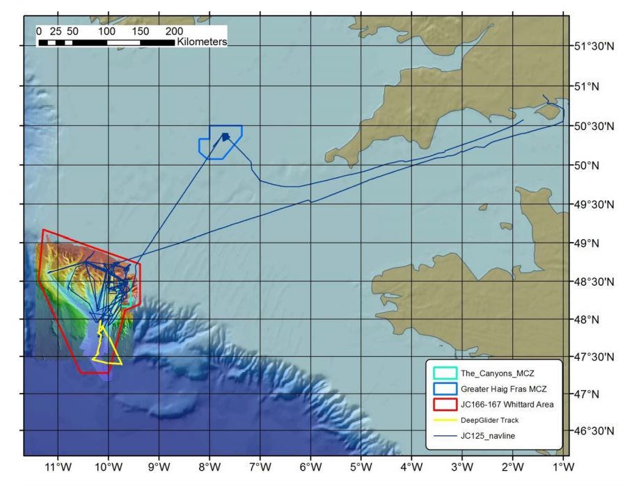
Sampling History
| JC035 (2009) | JC125 (2015) | JC166/7 (2018) | |
|---|---|---|---|
| ROV video/photography | Y | Y | Y |
| AUV video/photography | N | Y | Y |
| Shipboard Multibeam Bathymetry | Y | Y | Y |
| AUV Multibeam Bathymetry | N | Y | Y |
| AUV Sidescan Sonar | N | Y | Y |
| TOBI Sidescan Sonar | Y | Y | Y |
| ROV vibrocorer | N | Y | N |
| CTD casts | N | Y | N |
| SAPS | N | Y | N |
Related Fixed Station activities are detailed in Appendix 2
BODC Quality Control Flags
The following single character qualifying flags may be associated with one or more individual parameters with a data cycle:
| Flag | Description |
|---|---|
| Blank | Unqualified |
| < | Below detection limit |
| > | In excess of quoted value |
| A | Taxonomic flag for affinis (aff.) |
| B | Beginning of CTD Down/Up Cast |
| C | Taxonomic flag for confer (cf.) |
| D | Thermometric depth |
| E | End of CTD Down/Up Cast |
| G | Non-taxonomic biological characteristic uncertainty |
| H | Extrapolated value |
| I | Taxonomic flag for single species (sp.) |
| K | Improbable value - unknown quality control source |
| L | Improbable value - originator's quality control |
| M | Improbable value - BODC quality control |
| N | Null value |
| O | Improbable value - user quality control |
| P | Trace/calm |
| Q | Indeterminate |
| R | Replacement value |
| S | Estimated value |
| T | Interpolated value |
| U | Uncalibrated |
| W | Control value |
| X | Excessive difference |
SeaDataNet Quality Control Flags
The following single character qualifying flags may be associated with one or more individual parameters with a data cycle:
| Flag | Description |
|---|---|
| 0 | no quality control |
| 1 | good value |
| 2 | probably good value |
| 3 | probably bad value |
| 4 | bad value |
| 5 | changed value |
| 6 | value below detection |
| 7 | value in excess |
| 8 | interpolated value |
| 9 | missing value |
| A | value phenomenon uncertain |
| B | nominal value |
| Q | value below limit of quantification |
Appendix 1: JC278_CTD_JC278_CTD003
Related series for this Data Activity are presented in the table below. Further information can be found by following the appropriate links.
If you are interested in these series, please be aware we offer a multiple file download service. Should your credentials be insufficient for automatic download, the service also offers a referral to our Enquiries Officer who may be able to negotiate access.
| Series Identifier | Data Category | Start date/time | Start position | Cruise |
|---|---|---|---|---|
| 2308848 | Water sample data | 2025-06-01 05:56:36 | 48.4385 N, 9.74433 W | RRS James Cook JC278 |
| 2309090 | Water sample data | 2025-06-01 05:56:36 | 48.4385 N, 9.74433 W | RRS James Cook JC278 |
Appendix 2: Whittard Canyon - The Canyons Marine Conservation Zone
Related series for this Fixed Station are presented in the table below. Further information can be found by following the appropriate links.
If you are interested in these series, please be aware we offer a multiple file download service. Should your credentials be insufficient for automatic download, the service also offers a referral to our Enquiries Officer who may be able to negotiate access.
| Series Identifier | Data Category | Start date/time | Start position | Cruise |
|---|---|---|---|---|
| 2026920 | Bathymetry | 2009-06-09 00:00:00 | 47.1792 N, 11.2483 W | RRS James Cook JC035 |
| 2026932 | Bathymetry | 2009-06-09 00:00:00 | 48.4273 N, 11.2343 W | RRS James Cook JC035 |
| 2202723 | CTD or STD cast | 2009-06-22 14:25:05 | 48.15317 N, 10.53967 W | RRS James Cook JC036 |
| 2202735 | CTD or STD cast | 2009-07-09 18:58:19 | 48.81283 N, 11.15917 W | RRS James Cook JC036 |
| 2202747 | CTD or STD cast | 2009-07-10 23:22:15 | 48.2835 N, 10.314 W | RRS James Cook JC036 |
| 2202759 | CTD or STD cast | 2009-07-12 00:52:48 | 48.26533 N, 10.182 W | RRS James Cook JC036 |
| 2202760 | CTD or STD cast | 2009-07-18 05:48:17 | 48.60333 N, 9.9665 W | RRS James Cook JC036 |
| 2202772 | CTD or STD cast | 2009-07-26 03:59:18 | 48.653 N, 10.033 W | RRS James Cook JC036 |
| 2202803 | CTD or STD cast | 2015-08-13 21:32:12 | 47.9595 N, 10.217 W | RRS James Cook JC125 (JC124, JC126) |
| 2027020 | Bathymetry | 2015-08-14 01:23:00 | 47.5404 N, 11.2236 W | RRS James Cook JC125 (JC124, JC126) |
| 2027032 | Bathymetry | 2015-08-15 02:05:00 | 48.4621 N, 9.9608 W | RRS James Cook JC125 (JC124, JC126) |
| 2202815 | CTD or STD cast | 2015-08-15 15:56:36 | 48.38949 N, 9.99615 W | RRS James Cook JC125 (JC124, JC126) |
| 2202827 | CTD or STD cast | 2015-08-16 17:12:56 | 48.65512 N, 10.03444 W | RRS James Cook JC125 (JC124, JC126) |
| 2202839 | CTD or STD cast | 2015-08-20 03:56:28 | 48.65348 N, 10.03337 W | RRS James Cook JC125 (JC124, JC126) |
| 2202840 | CTD or STD cast | 2015-08-20 10:30:09 | 48.76099 N, 10.4609 W | RRS James Cook JC125 (JC124, JC126) |
| 2202852 | CTD or STD cast | 2015-08-25 10:31:46 | 48.46176 N, 9.63347 W | RRS James Cook JC125 (JC124, JC126) |
| 2202864 | CTD or STD cast | 2015-08-25 12:17:30 | 48.46583 N, 9.63871 W | RRS James Cook JC125 (JC124, JC126) |
| 2202876 | CTD or STD cast | 2015-08-25 13:59:18 | 48.4682 N, 9.64339 W | RRS James Cook JC125 (JC124, JC126) |
| 2202888 | CTD or STD cast | 2015-08-26 10:01:43 | 48.47488 N, 9.6532 W | RRS James Cook JC125 (JC124, JC126) |
| 2202907 | CTD or STD cast | 2015-08-26 13:34:15 | 48.46164 N, 9.63353 W | RRS James Cook JC125 (JC124, JC126) |
| 2202919 | CTD or STD cast | 2015-08-26 15:00:47 | 48.46574 N, 9.63858 W | RRS James Cook JC125 (JC124, JC126) |
| 2202920 | CTD or STD cast | 2015-08-26 18:36:18 | 48.46819 N, 9.64337 W | RRS James Cook JC125 (JC124, JC126) |
| 2202932 | CTD or STD cast | 2015-08-26 20:04:18 | 48.47199 N, 9.64881 W | RRS James Cook JC125 (JC124, JC126) |
| 2202944 | CTD or STD cast | 2015-08-26 21:54:21 | 48.48103 N, 9.6606 W | RRS James Cook JC125 (JC124, JC126) |
| 2202956 | CTD or STD cast | 2015-08-26 23:32:10 | 48.49106 N, 9.67511 W | RRS James Cook JC125 (JC124, JC126) |
| 2202968 | CTD or STD cast | 2015-09-01 08:36:10 | 48.47488 N, 9.65322 W | RRS James Cook JC125 (JC124, JC126) |
| 2202981 | CTD or STD cast | 2015-09-06 02:27:13 | 48.65368 N, 10.03353 W | RRS James Cook JC125 (JC124, JC126) |
| 2202993 | CTD or STD cast | 2015-09-06 12:37:15 | 48.48615 N, 10.04908 W | RRS James Cook JC125 (JC124, JC126) |
| 2026993 | Bathymetry | 2018-06-23 23:02:00 | 47.4704 N, 10.586 W | RRS James Cook JC166 (JC167) |
| 2027007 | Bathymetry | 2018-06-24 19:43:00 | 48.2761 N, 9.8577 W | RRS James Cook JC166 (JC167) |
| 2205929 | Hydrography time series at depth | 2019-07-08 06:25:09 | 48.62615 N, 10.00373 W | RRS Discovery DY103 |
| 2222318 | Currents -subsurface Eulerian | 2019-07-08 06:55:00 | 48.62615 N, 10.00373 W | RRS Discovery DY103 |
| 2222306 | Currents -subsurface Eulerian | 2019-07-08 07:00:00 | 48.62615 N, 10.00373 W | RRS Discovery DY103 |
| 2205917 | Hydrography time series at depth | 2019-07-08 07:12:21 | 48.62615 N, 10.00373 W | RRS Discovery DY103 |
| 2222343 | Currents -subsurface Eulerian | 2020-11-13 12:18:00 | 48.626 N, 10.004 W | RRS Discovery DY116 |
| 2222331 | Currents -subsurface Eulerian | 2020-11-13 12:30:00 | 48.626 N, 10.004 W | RRS Discovery DY116 |
| 2205930 | Hydrography time series at depth | 2020-11-13 13:00:01 | 48.3756 N, 10.024 W | RRS Discovery DY116 |
| 2205942 | Hydrography time series at depth | 2020-11-13 13:00:01 | 48.3756 N, 10.024 W | RRS Discovery DY116 |
| 2222367 | Currents -subsurface Eulerian | 2021-03-29 12:09:02 | 48.626 N, 9.996 W | RRS Discovery DY130 |
| 2206761 | Hydrography time series at depth | 2021-03-29 12:10:33 | 48.626 N, 9.996 W | RRS Discovery DY130 |
| 2206773 | Hydrography time series at depth | 2021-03-29 12:13:06 | 48.626 N, 9.996 W | RRS Discovery DY130 |
| 2222355 | Currents -subsurface Eulerian | 2021-03-29 12:24:51 | 48.626 N, 9.996 W | RRS Discovery DY130 |
| 2222379 | Currents -subsurface Eulerian | 2022-01-01 00:25:32 | 48.626 N, 9.996 W | RRS Discovery DY130 |
| 2225469 | Bathymetry | 2022-07-10 00:00:00 | 47.8623 N, 10.8343 W | RRS Discovery DY152 |
| 2225494 | Bathymetry | 2022-08-06 00:00:00 | 48.1325 N, 10.6492 W | RRS James Cook JC237 |
| 2202483 | CTD or STD cast | 2022-08-08 01:20:25 | 47.89354 N, 10.17301 W | RRS James Cook JC237 |
| 2202495 | CTD or STD cast | 2022-08-09 16:07:10 | 48.25988 N, 9.67387 W | RRS James Cook JC237 |
| 2202502 | CTD or STD cast | 2022-08-11 14:57:43 | 48.68134 N, 10.05642 W | RRS James Cook JC237 |
| 2202514 | CTD or STD cast | 2022-08-12 10:37:52 | 48.6533 N, 10.03587 W | RRS James Cook JC237 |
| 2202526 | CTD or STD cast | 2022-08-15 09:51:34 | 48.75935 N, 10.4597 W | RRS James Cook JC237 |
| 2202538 | CTD or STD cast | 2022-08-19 06:12:55 | 48.39767 N, 9.83574 W | RRS James Cook JC237 |
| 2202551 | CTD or STD cast | 2022-08-19 07:32:08 | 48.3976 N, 9.83558 W | RRS James Cook JC237 |
| 2202563 | CTD or STD cast | 2022-08-19 08:45:47 | 48.3977 N, 9.83563 W | RRS James Cook JC237 |
| 2202575 | CTD or STD cast | 2022-08-19 10:03:47 | 48.39771 N, 9.83557 W | RRS James Cook JC237 |
| 2202587 | CTD or STD cast | 2022-08-19 11:32:18 | 48.39793 N, 9.83535 W | RRS James Cook JC237 |
| 2202599 | CTD or STD cast | 2022-08-19 13:46:18 | 48.398 N, 9.83528 W | RRS James Cook JC237 |
| 2202606 | CTD or STD cast | 2022-08-19 15:41:20 | 48.39802 N, 9.83522 W | RRS James Cook JC237 |
| 2202618 | CTD or STD cast | 2022-08-19 17:15:07 | 48.39802 N, 9.83522 W | RRS James Cook JC237 |
| 2202631 | CTD or STD cast | 2022-08-21 13:43:33 | 48.52944 N, 9.93624 W | RRS James Cook JC237 |
| 2202643 | CTD or STD cast | 2022-08-21 18:33:08 | 48.6527 N, 10.03528 W | RRS James Cook JC237 |
| 2202655 | CTD or STD cast | 2022-08-21 20:59:11 | 48.73153 N, 10.09842 W | RRS James Cook JC237 |
| 2202667 | CTD or STD cast | 2022-08-22 18:40:04 | 48.41286 N, 9.83279 W | RRS James Cook JC237 |
| 2202679 | CTD or STD cast | 2022-08-23 13:46:46 | 48.57121 N, 9.93517 W | RRS James Cook JC237 |
| 2202692 | CTD or STD cast | 2022-08-31 10:55:23 | 48.65286 N, 10.03526 W | RRS James Cook JC237 |
| 2202711 | CTD or STD cast | 2022-09-01 15:18:27 | 48.31993 N, 9.79096 W | RRS James Cook JC237 |
| 2243704 | Water sample data | 2023-05-07 11:43:02 | 48.6033 N, 9.9683 W | RRS James Cook JC247 |
| 2242910 | Bathymetry | 2023-06-18 00:00:00 | 48.02085 N, 11.15677 W | RRS Discovery DY166 |
| 2308640 | Water sample data | 2025-05-31 19:57:00 | 48.404 N, 9.695 W | RRS James Cook JC278 |
| 2308836 | Water sample data | 2025-05-31 19:57:00 | 48.404 N, 9.695 W | RRS James Cook JC278 |
| 2309089 | Water sample data | 2025-05-31 19:57:00 | 48.404 N, 9.695 W | RRS James Cook JC278 |
| 2308848 | Water sample data | 2025-06-01 05:56:36 | 48.4385 N, 9.74433 W | RRS James Cook JC278 |
| 2309090 | Water sample data | 2025-06-01 05:56:36 | 48.4385 N, 9.74433 W | RRS James Cook JC278 |
| 2308664 | Water sample data | 2025-06-02 05:53:35 | 48.511 N, 9.93133 W | RRS James Cook JC278 |
| 2308861 | Water sample data | 2025-06-02 05:53:35 | 48.511 N, 9.93133 W | RRS James Cook JC278 |
| 2309108 | Water sample data | 2025-06-02 05:53:35 | 48.511 N, 9.93133 W | RRS James Cook JC278 |

