Metadata Report for BODC Series Reference Number 1749363
Metadata Summary
Problem Reports
Data Access Policy
Narrative Documents
Project Information
Data Activity or Cruise Information
Fixed Station Information
BODC Quality Flags
SeaDataNet Quality Flags
Metadata Summary
Data Description |
|||||||||||||||||||||||||
|
|||||||||||||||||||||||||
Data Identifiers |
|||||||||||||||||||||||||
|
|||||||||||||||||||||||||
Time Co-ordinates(UT) |
|||||||||||||||||||||||||
|
|||||||||||||||||||||||||
Spatial Co-ordinates | |||||||||||||||||||||||||
|
|||||||||||||||||||||||||
Parameters |
|||||||||||||||||||||||||
|
|||||||||||||||||||||||||
|
|||||||||||||||||||||||||
Problem Reports
No Problem Report Found in the Database
Data Access Policy
Open Data
These data have no specific confidentiality restrictions for users. However, users must acknowledge data sources as it is not ethical to publish data without proper attribution. Any publication or other output resulting from usage of the data should include an acknowledgment.
If the Information Provider does not provide a specific attribution statement, or if you are using Information from several Information Providers and multiple attributions are not practical in your product or application, you may consider using the following:
"Contains public sector information licensed under the Open Government Licence v1.0."
Narrative Documents
Star-Oddi DST centi-T Temperature Recorder
Description
The Data Storage Tag (DST) centi-T is a small submersible data logger with a temperature sensor. Recorded data is stored in its internal memory with a real-time clock reference for each measurement.
The sensors are housed in a strong waterproof cylinder made of alumina (an implantable biocompatible ceramic).
Specifications
| Memory | 174,000 measurements in total; 261,819 bytes / temperature 1.5 bytes | ||
|---|---|---|---|
| Data Retention | 25 years | ||
| Temperature Data | Temperature resolution | 0.032 °C | |
| Temperature accuracy | ± 0.1 °C | ||
| Temperature range | - 1 °C to + 40 °C | ||
| Temperature response time | Time constant (63%) reached in 20 sec. | ||
| Dimensions | 15 mm x 46 mm | ||
| Communication Link | Downloaded via PC interface box. Connects to a computer via a RS-232C standard serial interface. | ||
| Battery | A 3.6 V lithium battery with a life of 7 years for a sampling interval of 10 minutes or greater. | ||
Further details are available in the manufacturer's centi-T specification document.
RRS Discovery DY018 Towed Temperature and Fluorometer (T-F) Chain BODC processing report
The files were processed and calibrated at the National Oceanogrpahy Centre, Liverpool and were sent to BODC in Matlab format. The files contain the full period of data and two smaller time periods within the full period, relating to when the instruments were in sinks of saltwater. The full period of data were used to create the time series ingested at BODC. Although the data were from a towed chain, the originators removed a period (12:48 to 13:09 on the 18/11/2014) where the ship reached speeds in excess of 2 m/s and effectively treating the data as stationary time series at depth.
The data were converted to BODC internal format (a netCDF subset) using BODC established procedures. The following table shows how the variables within the originator's files were mapped to appropriate BODC parameter codes:
| Originator's Parameter Name | Units | Originator Description | BODC Parameter Code | Units | Comments |
|---|---|---|---|---|---|
| PressDur | - | Pressure | PRESPS01 | dbar | - |
| TempDur | - | Temperature | TEMPPR01 | °C | - |
| SalinDur | - | Practical salinity | PSALPR01 | - | - |
| ConducDur | S/m | Conductivity | CNDCPR01 | S/m | - |
| ChlorDur | µg/l | Chlorophyll | CPHLPS01 | mg/m3 | Derived by BODC |
Reformatted data were visualised using the in-house graphical editor EDSERPLO. Quality control flags were applied to data as necessary.
RRS Discovery DY018 Towed Temperature and Fluorometer (T-F) Chain originator processing
On RSS Discovery DY018, a T-F chain with temperature and fluorescence logging instruments attached was towed from 09:43 17/11/2014 to 17:07 19/11/2014 in an attempt to capture data related to cross-shelf exchange. The originators provided a comprehensive document (Birt, 2015) describing the activity and all processing of the data and should be referred to fully understand the processing carried out.
References
Birt, D. 2015 DY018 Towed Temperature and Fluorometer (T-F) Chain processing report
Project Information
Shelf Sea Biogeochemistry (SSB) Programme
Shelf Sea Biogeochemistry (SSB) is a £10.5 million, six-year (2011-2017) research programme, jointly funded by the Natural Environment Research Council (NERC) and the Department for Environment, Food and Rural Affairs (DEFRA). The aim of the research is to reduce the uncertainty in our understanding of nutrient and carbon cycling within the shelf seas, and of their role in global biogeochemical cycles. SSB will also provide effective policy advice and make a significant contribution to the Living with Environmental Change programme.
Background
The Shelf Sea Biogeochemistry research programme directly relates to the delivery of the NERC Earth system science theme and aims to provide evidence that supports a number of marine policy areas and statutory requirements, such as the Marine Strategy Framework Directive and Marine and Climate Acts.
The shelf seas are highly productive compared to the open ocean, a productivity that underpins more than 90 per cent of global fisheries. Their importance to society extends beyond food production to include issues of biodiversity, carbon cycling and storage, waste disposal, nutrient cycling, recreation and renewable energy resources.
The shelf seas have been estimated to be the most valuable biome on Earth, but they are under considerable stress, as a result of anthropogenic nutrient loading, overfishing, habitat disturbance, climate change and other impacts.
However, even within the relatively well-studied European shelf seas, fundamental biogeochemical processes are poorly understood. For example: the role of shelf seas in carbon storage; in the global cycles of key nutrients (nitrogen, phosphorus, silicon and iron); and in determining primary and secondary production, and thereby underpinning the future delivery of many other ecosystem services.
Improved knowledge of such factors is not only required by marine policymakers; it also has the potential to increase the quality and cost-effectiveness of management decisions at the local, national and international levels under conditions of climate change.
The Shelf Sea Biogeochemistry research programme will take a holistic approach to the cycling of nutrients and carbon and the controls on primary and secondary production in UK and European shelf seas, to increase understanding of these processes and their role in wider biogeochemical cycles. It will thereby significantly improve predictive marine biogeochemical and ecosystem models over a range of scales.
The scope of the programme includes exchanges with the open ocean (transport on and off the shelf to a depth of around 500m), together with cycling, storage and release processes on the shelf slope, and air-sea exchange of greenhouse gases (carbon dioxide and nitrous oxide).
Further details are available on the SSB website.
Participants
15 different organisations are directly involved in research for SSB. These institutions are
- Centre for Environment, Fisheries and Aquaculture Science (Cefas)
- Meteorological Office
- National Oceanography Centre (NOC)
- Plymouth Marine Laboratory (PML)
- Scottish Association for Marine Science (SAMS) / Scottish Marine Institute (SMI)
- University of Aberdeen
- University of Bangor
- University of East Anglia (UEA)
- University of Edinburgh
- University of Essex
- University of Liverpool
- University of Oxford
- Plymouth University
- University of Portsmouth
- University of Southampton
In addition, there are third party institutions carrying out sampling work for SSB, but who are not involved in the programme itself. These are:
- The Agri-Food and Biosciences Institute (AFBI)
- Irish Marine Institute (MI)
- Marine Science Scotland (MSS)
Research details
Overall, five Work Packages have been funded by the SSB programme. These are described in brief below:
-
Work Package 1: Carbon and Nutrient Dynamics and Fluxes over Shelf Systems (CaNDyFloSS).
This work package aims to perform a comprehensive study of the cycling of nutrients and carbon throughout the water column over the whole north-west European shelf. This will allow the fluxes of nutrients and carbon between the shelf and the deep ocean and atmosphere to be quantified, establishing the role of the north-west European continental shelf in the global carbon cycle. -
Work Package 2: Biogeochemistry, macronutrient and carbon cycling in the benthic layer.
This work package aims are to map the sensitivity and status of seabed habitats, based on physical conditions, ecological community structure and the size and dynamics of the nitrogen and carbon pools found there. This information will be used, in conjunction with some laboratory-based work, to generate an understanding of the potential impacts on the benthic community as a result of changing environmental conditions, such as rising CO2 levels. -
Work Package 3: The supply of iron from shelf sediments to the ocean.
The research for this work package addresses the question of how currents, tides, weather and marine chemistry allow new iron to be transported away from the shallow shelf waters around the United Kingdom (UK), to the nearby open ocean. This will ultimately allow an improved understanding of how the transport of iron in shelf waters and shelf sediments influences phytoplankton growth in open oceans. This in turn improves the understanding of carbon dioxide uptake by phytoplankton. -
Work Package 4: Integrative modelling for Shelf Seas Biogeochemistry.
The aim of this work package is the development of a new shelf seas biogeochemical model system, coupled to a state of the art physical model, that is capable of predicting regional impacts of environmental change of timescales from days to decades. It is envisaged that the combination of predictive tools and new knowledge developed in this work package will underpin development and implementation of marine policy and marine forecasting systems. - Work Package 5: Data synthesis and management of marine and coastal carbon (DSMMAC).
This work package is funded by Defra and is also known by the name 'Blue Carbon'. The aim is to provide a process-based, quantitative assessment of the role of UK coastal waters and shelf seas in carbon storage and release, using existing data and understanding, and also emerging results from SSB fieldwork, experiments and modelling. Particular emphasis will be given to processes that may be influenced by human activities, and hence the opportunity for management interventions to enhance carbon sequestration.
Fieldwork and data collection
The campaign consists of the core cruises in the table below, to the marine shelf (and shelf-edge) of the Celtic Sea on board the NERC research vessels RRS Discovery and RRS James Cook. These cruises will focus on the physics and biogeochemistry of the benthic and pelagic zones of the water column, primarily around four main sampling sites in this area.
| Cruise identifier | Research ship | Cruise dates | Work packages |
|---|---|---|---|
| DY008 | RRS Discovery | March 2014 | WP 2 and WP 3 |
| JC105 | RRS James Cook | June 2014 | WP 1, WP 2 and WP 3 |
| DY026 | RRS Discovery | August 2014 | WP1, WP 2 and WP 3 |
| DY018 | RRS Discovery | November - December 2014 | WP 1 and WP 3 |
| DY021 (also known as DY008b) | RRS Discovery | March 2015 | WP 2 and WP 3 |
| DY029 | RRS Discovery | April 2015 | WP 1 and WP 3 |
| DY030 | RRS Discovery | May 2015 | WP 2 and WP 3 |
| DY033 | RRS Discovery | July 2015 | WP 1 and WP 3 |
| DY034 | RRS Discovery | August 2015 | WP 2 and WP 3 |
Core cruises will be supplemented by partner cruises led by Cefas, MI, MSS, Bangor University and AFBI, spanning the shelf seas and shelf-edges around United Kingdom and Republic of Ireland.
Activities will include coring, Conductivity Temperature and Depth (CTD) deployments, Acoustic Doppler Current Profilers (ADCP) surveys, moorings and wire-walker deployments, benthic lander observatories, autonomous gliders and submersible surveys, Marine Snow Catcher particulate matter analysis, plankton net hauls, in-situ sediment flume investigations and laboratory incubations with core and sea water samples.
Shelf Sea Biogeochemistry (SSB) Programme Work Package 1: CaNDyFloSS
Carbon and Nutrient Dynamics and Fluxes over Shelf Systems (CaNDyFloSS) is a £2.76 million component of the Natural Environment Research Council (NERC) Shelf Sea Biogeochemistry (SSB) research programme, running from 2013 to 2017. It is jointly funded by NERC and the Department for Environment, Food and Rural Affairs (DEFRA). The aim of the research is to perform a comprehensive study of the cycling of nutrients and carbon throughout the water column over the whole north-west European shelf. This will allow the fluxes of nutrients and carbon between the shelf and the deep ocean and atmosphere to be quantified, establishing the role of the north-west European continental shelf in the global carbon cycle.
Background
Shelf seas are the primary regions of human marine resource exploitation, including both renewable and fossil fuel energy sources, recreation, trade and food production. They provide 90% of global fish catches which form an important source of food to much of the global population. They also play an important role in the ecosystem services provided by the oceans as a whole, in particular in storing carbon away from the atmosphere.
Physical and biochemical processes in shelf seas influence the removal of CO2 from the atmosphere and the subsequent storage of carbon in the deep ocean. Biological growth draws carbon out of the water, which is then replaced by carbon in CO2 from the atmosphere. In the shelf seas this growth is supported by terrestrial and open ocean sources of nutrients, implying intimate roles for both the terrestrial biosphere and the open ocean environment in regulating shelf sea climate services. The oceans can also be a major source or sink for other greenhouse gases, including nitrous oxide (N2O), with the shallow shelf sea thought to play a key role.
The spatial extent of the submerged continental shelves varies greatly. The NW European shelf sea is one of the largest and hence is likely to play a significant role in marine biogeochemical cycling, alongside providing a useful model for other systems. However, even in this relatively well studied region, there is a lack of detailed understanding of the principal controls on the cycling of carbon and the major nutrient elements, nitrogen, phosphorus and silicon. Consequently it is also difficult to predict how the cycling of these elements and hence the carbon removal they support may be altered by ongoing and potential future global change. This work package aims to address these uncertainties through a comprehensive study of the cycling of the major nutrients and carbon throughout the water column over the NW European shelf sea system.
Further details are available on the SSB website.
Participants
9 different organisations are directly involved in research for SSB Work Package 1. These institutions are
- Centre for Environment, Fisheries and Aquaculture Science (Cefas)
- National Oceanography Centre (NOC)
- Plymouth Marine Laboratory (PML)
- Scottish Association for Marine Science (SAMS) / Scottish Marine Institute (SMI)
- University of Aberdeen
- University of Bangor
- University of East Anglia (UEA)
- University of Liverpool
- University of Southampton
In addition, there are third party institutions carrying out sampling work for SSB Work Package 1, but who are not involved in the programme itself. These are:
- The Agri-Food and Biosciences Institute (AFBI)
- Irish Marine Institute (MI)
- Marine Science Scotland (MSS)
Objectives
Two overarching objectives are defined for this Work Package.
-
Objective 1: Estimate the size of the continental shelf carbon pump over the whole north-west European shelf.
This will consist of two principal activities. (1) Over a 12 month period, observations of air-sea CO2 fluxes will be made to provide a synoptic estimate of the magnitude of carbon update by the whole shelf system. (2) Concentrations of carbon (C), nitrogen (N), phosphate (P) and silicate (Si) will be estimated in water flowing on and off the shelf. These estimates will be coupled to estimates of flow and dispersion along the shelf edge, through collaboration with the NERC Fluxes across Sloping Topography of the North East Atlantic (FASTNEt) programme to allow an observational estimate of the net off-shelf transport of C, N, P and Si. -
Objective 2: Determine the relative importance of external nutrient sources and internal biogeochemical cycling in maintaining the continental shelf pump.
Estimates of the flux of nutrients and carbon generated in Objective 1 will be used to determine the estimation of any excess of on-shelf nutrient supply, relative to that of carbon. Work Package 1 will then quantify the processes which govern internal biogeochemical cycling by measuring the uptake ratios of N, P, Si and C into phytoplankton and the element and energy balance of organic matter production by autotrophs. Potential modifications to the relative concentrations and uptake of C, N, P and Si in the thermocline and sediment food webs will also be assessed, as will the relative importance of microbial and zooplankton turnover in controlling C, N, P and Si.
Fieldwork and data collection
Data for Objective 1 will be provided using pCO2 systems aboard third party vessels and ferry boxes, along with measurements made through the FASTNEt programme and through the Work Package 1 process cruises detailed below. The third party cruises will be undertaken by Cefas, MI, MSS, University of Bangor and AFBI, spanning the shelf seas and shelf-edges around the United Kingdom and the Republic of Ireland.
The Work Package 1 process cruises will provide data for Objective 1 and Objective 2 and are listed in the table below. The study area is the marine shelf (and shelf-edge) of the Celtic Sea. Work will be carried out on board the NERC research vessels RRS Discovery and RRS James Cook. These cruises will focus on the physics and biogeochemistry of the benthic and pelagic zones of the water column, primarily around four main sampling sites in this area.
| Cruise identifier | Research ship | Cruise dates | Work packages |
|---|---|---|---|
| JC105 | RRS James Cook | June 2014 | WP 1, WP 2 and WP 3 |
| DY026 | RRS Discovery | August 2014 | WP1, WP 2 and WP 3 |
| DY018 | RRS Discovery | November - December 2014 | WP 1 and WP 3 |
| DY029 | RRS Discovery | April 2015 | WP 1 and WP 3 |
| DY033 | RRS Discovery | July 2015 | WP 1 and WP 3 |
Activities will include Conductivity Temperature and Depth (CTD) deployments, Acoustic Doppler Current Profilers (ADCP) surveys, moorings and wire-walker deployments, autonomous gliders and submersible surveys, Marine Snow Catcher particulate matter analysis, plankton net hauls and laboratory incubations with sea water samples.
Data Activity or Cruise Information
Data Activity
| Start Date (yyyy-mm-dd) | 2014-11-09 |
| End Date (yyyy-mm-dd) | 2014-12-03 |
| Organization Undertaking Activity | National Oceanography Centre, Liverpool |
| Country of Organization | United Kingdom |
| Originator's Data Activity Identifier | DY018_TF_Chain |
| Platform Category | subsurface mooring |
DY018 towed temperature fluorometer chain (T-F Chain)
The T-F chain was deployed from the RRS Discovery between 09:43 17/11/14 and 17:07 19/11/14 with the aim of capturing data related to the cross-shelf exchange.
Instruments deployed on the mooring
Instrument codes
FLB - Wetlabs internally recording Eco Chlorophyll-a fluorometer
DST - Star Oddi Centi internally recording temperature/T+ pressure logger
RBR Solo - Internally recording temperature logger
Starmon Mini - Star Oddi internally recording temperature logger
MicroCAT - Seabird SBE37 internally recording CT/CTD sensor
| Nominal depth (m) | Instrument type | Instrument serial number |
|---|---|---|
| 7.5 | FLB | 775 |
| 7.5 | DST | 3604 |
| 10 | FLB | 776 |
| 10 | DST | 3613 |
| 17.5 | MicroCAT RS232 | 4966 |
| 20 | FLB | 777 |
| 20 | DST | 3608 |
| 25 | FLB | 778 |
| 25 | DST | 3619 |
| xx | FLB | 779 |
| xx | DST | 3270 |
| 40 | Starmon Mini | 2849 |
| xx | FLB | 780 |
| xx | DST | 3271 |
| xx | FLB | 907 |
| xx | DST | 3655 |
| 60 | Starmon mini | 2842 |
| xx | FLB | 937 |
| xx | DST | 5269 |
| xx | MicroCAT RS232 with pressure | 5793 |
| 82.5 | Starmon mini | 2841 |
| 90 | FLB | 938 |
| 90 | DST | 5270 |
| 95 | RBR Solo | 76797 |
| 97.5 | RBR Solo | 76798 |
| 105 | RBR Solo | 76799 |
| xx | FLB | 1712 |
| xx | DST | 5269 |
| 120 | RBR Solo | 76800 |
| 130 | MicroCAT RS485 | 2991 |
| 132.5 | RBR Solo | 76801 |
| 135 | *Starmon Mini | 2840 |
| 140 | RBR Solo | 76802 |
| 142.5 | Starmon Mini | 2838 |
| 145 | Starmon Mini | 2836 |
| 147.5 | Starmon Mini | 2837 |
| 150 | RBR Solo | 76803 |
| 157.5 | RBR Solo | 76804 |
| 164 | RBR Solo | 76805 |
| xx | MicroCAT RS232 with pressure | 5433 |
| 177.5 | RBR Solo | 76806 |
| 185 | RBR Solo | 76807 |
| xx | MicroCAT RS232 with pressure | 5790 |
Where depth is marked as 'xx' the instrument was lost during deployment and no data are available.
*Instrument failed to record any data.
Related Data Activity activities are detailed in Appendix 1
Cruise
| Cruise Name | DY018 (GApr04) |
| Departure Date | 2014-11-09 |
| Arrival Date | 2014-12-02 |
| Principal Scientist(s) | Jonathan Sharples (University of Liverpool Department of Earth, Ocean and Ecological Sciences) |
| Ship | RRS Discovery |
Complete Cruise Metadata Report is available here
Fixed Station Information
Fixed Station Information
| Station Name | CS2 |
| Category | Offshore area |
| Latitude | 48° 33.23' N |
| Longitude | 9° 29.17' W |
| Water depth below MSL | 200.0 m |
Physical-Biological Control of New Production within the Seasonal Thermocline: Fixed Station CS2
This station is positioned close to the edge of the north-west European shelf edge (see figure below). It was first visited by the RRS James Clark Ross (JR98) in 2003 and then by the RRS Charles Darwin (CD173) in 2005. This station was then re-visited in 2014 during the RRS Discovery cruise DY018, as part of work package I of the Shelf Seas Biogeochemistry project. The station has a mean water depth 201 m at the following co-ordinates:
| Box Corner | Latitude | Longitude |
|---|---|---|
| North-west corner | 48.5838° | -9.5497° |
| South-east corner | 48.4998° | -9.4364° |
The position of this station relative to the other sites visited during JR98, CD173 and DY018 can be seen from the figure below.
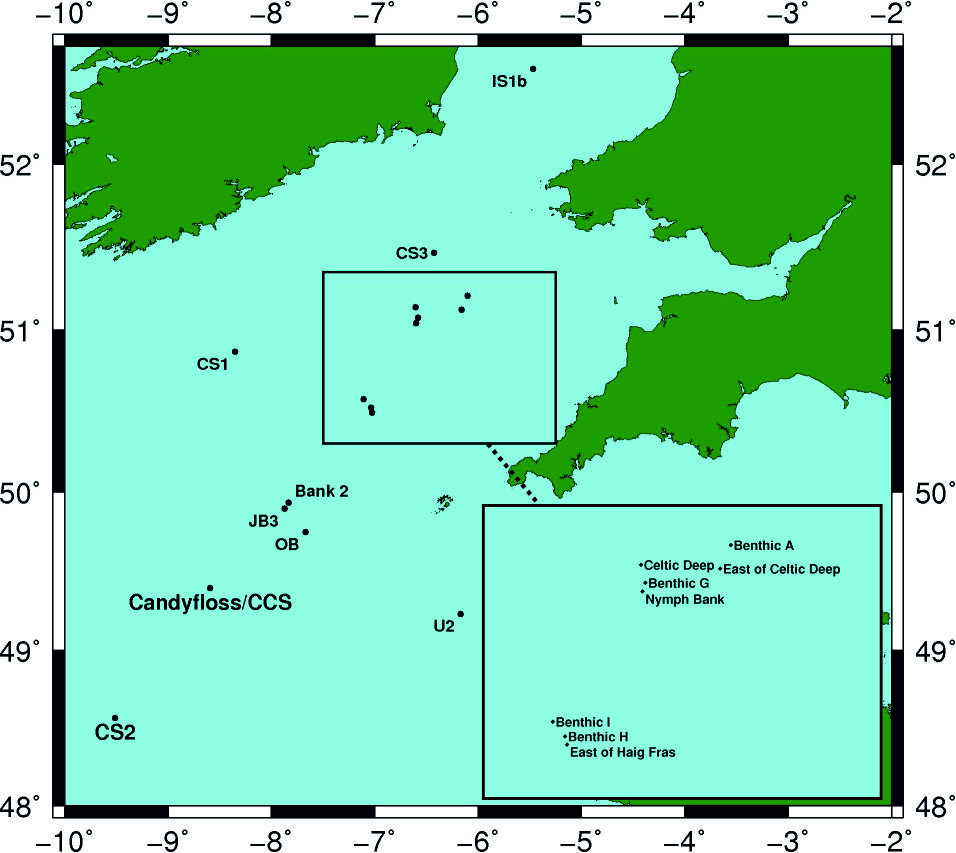
The following table describes which sites were visited during which cruises
| JB3 | Bank 2 | OB | IS1b | CS1 | CS2 | CS3 | U2 | Candyfloss/CCS | Benthic A | Benthic H | Benthic I | Benthic G | East of Haig Fras | Nymph Bank | Celtic Deep | East of Celtic Deep | |
|---|---|---|---|---|---|---|---|---|---|---|---|---|---|---|---|---|---|
| JR98 | - | - | - | X | X | X | X | X | - | - | - | - | - | - | - | - | - |
| CD173 | X | X | X | - | - | - | - | X | - | - | - | - | - | - | - | - | - |
| DY018 | - | - | - | - | - | X | - | - | X | X | X | X | X | X | X | X | X |
The deployment and sampling history, to date, for this station is summarised below:
Sampling History
| JR98 | CD173 | DY018 | |
|---|---|---|---|
| CTD casts | 30 | 15 | 15 |
| Free-fall light yo-yo profiles | - | 153 | - |
| Profiling radiometer | - | 16 | - |
| Zooplankton net hauls | - | - | 32 |
| Box cores | - | - | 5 |
| Marine snow catcher deployments | - | - | 17 |
| Stand Alone Pump Systems (SAPS) | - | - | 2 |
Mooring deployments
| Latitude | Longitude | Water depth (m) | Moored instrument | Deployment date | Recovery date | Deployment cruise | Recovery cruise | Comments |
|---|---|---|---|---|---|---|---|---|
| 48.532° | -9.463° | 200 | Surface temperature toroid | 2003-07-28 | 2003-08-12 | JR98 | JR98 | - |
| 48.532° | -9.463° | 200 | Thermistor chain throughout water column | 2003-07-28 | 2003-08-12 | JR98 | JR98 | - |
| 48.532° | -9.463° | 200 | Sub-surface 600 kHz ADCP | 2003-07-28 | 2003-08-12 | JR98 | JR98 | - |
| 48.532° | -9.463° | 200 | Aanderaa RCM7 current meter/CTD | 2003-07-28 | 2003-08-12 | JR98 | JR98 | - |
| 48.532° | -9.463° | 200 | Seabed frame 150 kHz ADCP | 2003-07-28 | 2003-08-12 | JR98 | JR98 | - |
| 48.532° | -9.463° | 200 | Seabed frame 300 kHz ADCP | 2003-07-28 | 2003-08-12 | JR98 | JR98 | - |
| 48.571° | -9.509° | 200 | Thermistor chain throughout water column | 2005-07-17 | 2005-07-24 | CD173 | CD173 | - |
| 48.573° | -9.51° | 194 | Sub-surface 300 kHz ADCP | 2005-07-17 | 2005-07-24 | CD173 | CD173 | - |
| 48.572° | -9.508° | 196 | Seabed frame 300 kHz ADCP | 2005-07-17 | 2005-07-24 | CD173 | CD173 | - |
| 48.571° | -9.507° | 202 | Seabed frame 150 kHz ADCP | 2005-07-17 | 2005-07-24 | CD173 | CD173 | - |
| - | - | 205 | T-F chain | 2014-11-17 09:03 UTC | 2014-11-19 17:07 UTC | DY018 | DY018 | - |
Related Fixed Station activities are detailed in Appendix 2
BODC Quality Control Flags
The following single character qualifying flags may be associated with one or more individual parameters with a data cycle:
| Flag | Description |
|---|---|
| Blank | Unqualified |
| < | Below detection limit |
| > | In excess of quoted value |
| A | Taxonomic flag for affinis (aff.) |
| B | Beginning of CTD Down/Up Cast |
| C | Taxonomic flag for confer (cf.) |
| D | Thermometric depth |
| E | End of CTD Down/Up Cast |
| G | Non-taxonomic biological characteristic uncertainty |
| H | Extrapolated value |
| I | Taxonomic flag for single species (sp.) |
| K | Improbable value - unknown quality control source |
| L | Improbable value - originator's quality control |
| M | Improbable value - BODC quality control |
| N | Null value |
| O | Improbable value - user quality control |
| P | Trace/calm |
| Q | Indeterminate |
| R | Replacement value |
| S | Estimated value |
| T | Interpolated value |
| U | Uncalibrated |
| W | Control value |
| X | Excessive difference |
SeaDataNet Quality Control Flags
The following single character qualifying flags may be associated with one or more individual parameters with a data cycle:
| Flag | Description |
|---|---|
| 0 | no quality control |
| 1 | good value |
| 2 | probably good value |
| 3 | probably bad value |
| 4 | bad value |
| 5 | changed value |
| 6 | value below detection |
| 7 | value in excess |
| 8 | interpolated value |
| 9 | missing value |
| A | value phenomenon uncertain |
| B | nominal value |
| Q | value below limit of quantification |
Appendix 1: DY018_TF_Chain
Related series for this Data Activity are presented in the table below. Further information can be found by following the appropriate links.
If you are interested in these series, please be aware we offer a multiple file download service. Should your credentials be insufficient for automatic download, the service also offers a referral to our Enquiries Officer who may be able to negotiate access.
| Series Identifier | Data Category | Start date/time | Start position | Cruise |
|---|---|---|---|---|
| 1749283 | Fluorescence or pigments | 2014-11-17 10:00:00 | 48.57086 N, 9.5097 W | RRS Discovery DY018 (GApr04) |
| 1749295 | Fluorescence or pigments | 2014-11-17 10:00:00 | 48.57086 N, 9.5097 W | RRS Discovery DY018 (GApr04) |
| 1749302 | Fluorescence or pigments | 2014-11-17 10:00:00 | 48.57086 N, 9.5097 W | RRS Discovery DY018 (GApr04) |
| 1749314 | Fluorescence or pigments | 2014-11-17 10:00:00 | 48.57086 N, 9.5097 W | RRS Discovery DY018 (GApr04) |
| 1749326 | Fluorescence or pigments | 2014-11-17 10:00:00 | 48.57086 N, 9.5097 W | RRS Discovery DY018 (GApr04) |
| 1749338 | Hydrography time series at depth | 2014-11-17 10:00:00 | 48.57086 N, 9.5097 W | RRS Discovery DY018 (GApr04) |
| 1749351 | Hydrography time series at depth | 2014-11-17 10:00:00 | 48.57086 N, 9.5097 W | RRS Discovery DY018 (GApr04) |
| 1749375 | Hydrography time series at depth | 2014-11-17 10:00:00 | 48.57086 N, 9.5097 W | RRS Discovery DY018 (GApr04) |
| 1749399 | Hydrography time series at depth | 2014-11-17 10:00:00 | 48.57086 N, 9.5097 W | RRS Discovery DY018 (GApr04) |
| 1749406 | Hydrography time series at depth | 2014-11-17 10:00:00 | 48.57086 N, 9.5097 W | RRS Discovery DY018 (GApr04) |
| 1749418 | Hydrography time series at depth | 2014-11-17 10:00:00 | 48.57086 N, 9.5097 W | RRS Discovery DY018 (GApr04) |
| 1749431 | Hydrography time series at depth | 2014-11-17 10:00:00 | 48.57086 N, 9.5097 W | RRS Discovery DY018 (GApr04) |
| 1749443 | Hydrography time series at depth | 2014-11-17 10:00:00 | 48.57086 N, 9.5097 W | RRS Discovery DY018 (GApr04) |
| 1749455 | Hydrography time series at depth | 2014-11-17 10:00:00 | 48.57086 N, 9.5097 W | RRS Discovery DY018 (GApr04) |
| 1749467 | Hydrography time series at depth | 2014-11-17 10:00:00 | 48.57086 N, 9.5097 W | RRS Discovery DY018 (GApr04) |
| 1749479 | Hydrography time series at depth | 2014-11-17 10:00:00 | 48.57086 N, 9.5097 W | RRS Discovery DY018 (GApr04) |
| 1749480 | Hydrography time series at depth | 2014-11-17 10:00:00 | 48.57086 N, 9.5097 W | RRS Discovery DY018 (GApr04) |
| 1749492 | Hydrography time series at depth | 2014-11-17 10:00:00 | 48.57086 N, 9.5097 W | RRS Discovery DY018 (GApr04) |
| 1749511 | Hydrography time series at depth | 2014-11-17 10:00:00 | 48.57086 N, 9.5097 W | RRS Discovery DY018 (GApr04) |
| 1749523 | Hydrography time series at depth | 2014-11-17 10:00:00 | 48.57086 N, 9.5097 W | RRS Discovery DY018 (GApr04) |
| 1749535 | Hydrography time series at depth | 2014-11-17 10:00:00 | 48.57086 N, 9.5097 W | RRS Discovery DY018 (GApr04) |
| 1749547 | Hydrography time series at depth | 2014-11-17 10:00:00 | 48.57086 N, 9.5097 W | RRS Discovery DY018 (GApr04) |
| 1749559 | Hydrography time series at depth | 2014-11-17 10:00:00 | 48.57086 N, 9.5097 W | RRS Discovery DY018 (GApr04) |
| 1749560 | Hydrography time series at depth | 2014-11-17 10:00:00 | 48.57086 N, 9.5097 W | RRS Discovery DY018 (GApr04) |
| 1749572 | Hydrography time series at depth | 2014-11-17 10:00:00 | 48.57086 N, 9.5097 W | RRS Discovery DY018 (GApr04) |
| 1749584 | Hydrography time series at depth | 2014-11-17 10:00:00 | 48.57086 N, 9.5097 W | RRS Discovery DY018 (GApr04) |
| 1749596 | Hydrography time series at depth | 2014-11-17 10:00:00 | 48.57086 N, 9.5097 W | RRS Discovery DY018 (GApr04) |
| 1749387 | Hydrography time series at depth | 2014-11-17 10:00:30 | 48.57086 N, 9.5097 W | RRS Discovery DY018 (GApr04) |
Appendix 2: CS2
Related series for this Fixed Station are presented in the table below. Further information can be found by following the appropriate links.
If you are interested in these series, please be aware we offer a multiple file download service. Should your credentials be insufficient for automatic download, the service also offers a referral to our Enquiries Officer who may be able to negotiate access.
| Series Identifier | Data Category | Start date/time | Start position | Cruise |
|---|---|---|---|---|
| 1106504 | CTD or STD cast | 2003-07-27 21:58:02 | 48.49983 N, 9.54967 W | RRS James Clark Ross JR20030725 (JR98) |
| 1106528 | CTD or STD cast | 2003-07-29 02:56:59 | 48.538 N, 9.46383 W | RRS James Clark Ross JR20030725 (JR98) |
| 1106541 | CTD or STD cast | 2003-07-29 03:58:02 | 48.538 N, 9.46417 W | RRS James Clark Ross JR20030725 (JR98) |
| 1106553 | CTD or STD cast | 2003-07-29 05:20:59 | 48.538 N, 9.46417 W | RRS James Clark Ross JR20030725 (JR98) |
| 1106565 | CTD or STD cast | 2003-07-29 06:01:00 | 48.538 N, 9.464 W | RRS James Clark Ross JR20030725 (JR98) |
| 1106577 | CTD or STD cast | 2003-07-29 06:58:02 | 48.538 N, 9.46417 W | RRS James Clark Ross JR20030725 (JR98) |
| 1106589 | CTD or STD cast | 2003-07-29 08:01:58 | 48.538 N, 9.464 W | RRS James Clark Ross JR20030725 (JR98) |
| 1106590 | CTD or STD cast | 2003-07-29 09:17:00 | 48.538 N, 9.46417 W | RRS James Clark Ross JR20030725 (JR98) |
| 1106608 | CTD or STD cast | 2003-07-29 10:22:57 | 48.538 N, 9.464 W | RRS James Clark Ross JR20030725 (JR98) |
| 1106621 | CTD or STD cast | 2003-07-29 11:15:04 | 48.53783 N, 9.464 W | RRS James Clark Ross JR20030725 (JR98) |
| 1106633 | CTD or STD cast | 2003-07-29 12:28:57 | 48.53783 N, 9.464 W | RRS James Clark Ross JR20030725 (JR98) |
| 1106645 | CTD or STD cast | 2003-07-29 13:37:03 | 48.53783 N, 9.464 W | RRS James Clark Ross JR20030725 (JR98) |
| 1106657 | CTD or STD cast | 2003-07-29 14:06:00 | 48.53783 N, 9.464 W | RRS James Clark Ross JR20030725 (JR98) |
| 1106669 | CTD or STD cast | 2003-07-29 15:00:00 | 48.538 N, 9.464 W | RRS James Clark Ross JR20030725 (JR98) |
| 1106670 | CTD or STD cast | 2003-07-29 16:12:00 | 48.538 N, 9.464 W | RRS James Clark Ross JR20030725 (JR98) |
| 1106682 | CTD or STD cast | 2003-07-29 17:00:58 | 48.538 N, 9.46417 W | RRS James Clark Ross JR20030725 (JR98) |
| 1106694 | CTD or STD cast | 2003-07-29 18:00:00 | 48.53783 N, 9.464 W | RRS James Clark Ross JR20030725 (JR98) |
| 1106701 | CTD or STD cast | 2003-07-29 18:58:02 | 48.53783 N, 9.46417 W | RRS James Clark Ross JR20030725 (JR98) |
| 1106713 | CTD or STD cast | 2003-07-29 19:59:57 | 48.53783 N, 9.46417 W | RRS James Clark Ross JR20030725 (JR98) |
| 1106725 | CTD or STD cast | 2003-07-29 20:57:59 | 48.53783 N, 9.464 W | RRS James Clark Ross JR20030725 (JR98) |
| 1106737 | CTD or STD cast | 2003-07-29 21:57:01 | 48.538 N, 9.464 W | RRS James Clark Ross JR20030725 (JR98) |
| 1106749 | CTD or STD cast | 2003-07-29 23:07:00 | 48.538 N, 9.46383 W | RRS James Clark Ross JR20030725 (JR98) |
| 1106750 | CTD or STD cast | 2003-07-29 23:56:59 | 48.53783 N, 9.464 W | RRS James Clark Ross JR20030725 (JR98) |
| 1106762 | CTD or STD cast | 2003-07-30 00:58:02 | 48.53783 N, 9.464 W | RRS James Clark Ross JR20030725 (JR98) |
| 1106774 | CTD or STD cast | 2003-07-30 01:57:04 | 48.53783 N, 9.464 W | RRS James Clark Ross JR20030725 (JR98) |
| 1106786 | CTD or STD cast | 2003-07-30 02:56:59 | 48.53833 N, 9.46317 W | RRS James Clark Ross JR20030725 (JR98) |
| 1106798 | CTD or STD cast | 2003-07-30 03:59:02 | 48.538 N, 9.464 W | RRS James Clark Ross JR20030725 (JR98) |
| 1106805 | CTD or STD cast | 2003-07-30 05:09:01 | 48.538 N, 9.464 W | RRS James Clark Ross JR20030725 (JR98) |
| 1108326 | CTD or STD cast | 2003-08-12 06:46:57 | 48.52383 N, 9.45533 W | RRS James Clark Ross JR20030725 (JR98) |
| 1108338 | CTD or STD cast | 2003-08-12 11:25:00 | 48.52883 N, 9.47533 W | RRS James Clark Ross JR20030725 (JR98) |
| 737376 | CTD or STD cast | 2005-07-17 18:57:00 | 48.575 N, 9.51433 W | RRS Charles Darwin CD173 |
| 737388 | CTD or STD cast | 2005-07-17 21:14:00 | 48.57517 N, 9.515 W | RRS Charles Darwin CD173 |
| 737407 | CTD or STD cast | 2005-07-17 23:07:00 | 48.57617 N, 9.51083 W | RRS Charles Darwin CD173 |
| 737419 | CTD or STD cast | 2005-07-18 00:58:00 | 48.57533 N, 9.50133 W | RRS Charles Darwin CD173 |
| 737420 | CTD or STD cast | 2005-07-18 07:19:00 | 48.568 N, 9.50233 W | RRS Charles Darwin CD173 |
| 1174790 | PAR radiance and irradiance | 2005-07-18 09:32:47 | 48.532 N, 9.463 W | RRS Charles Darwin CD173 |
| 1174808 | PAR radiance and irradiance | 2005-07-18 09:39:45 | 48.532 N, 9.463 W | RRS Charles Darwin CD173 |
| 737432 | CTD or STD cast | 2005-07-18 12:02:00 | 48.56817 N, 9.5115 W | RRS Charles Darwin CD173 |
| 1174821 | PAR radiance and irradiance | 2005-07-18 14:02:45 | 48.532 N, 9.463 W | RRS Charles Darwin CD173 |
| 1174833 | PAR radiance and irradiance | 2005-07-18 14:07:22 | 48.532 N, 9.463 W | RRS Charles Darwin CD173 |
| 737444 | CTD or STD cast | 2005-07-18 16:22:00 | 48.5705 N, 9.49217 W | RRS Charles Darwin CD173 |
| 737456 | CTD or STD cast | 2005-07-18 18:39:00 | 48.56867 N, 9.48233 W | RRS Charles Darwin CD173 |
| 737616 | CTD or STD cast | 2005-07-23 03:00:00 | 48.57167 N, 9.48967 W | RRS Charles Darwin CD173 |
| 737628 | CTD or STD cast | 2005-07-23 07:18:00 | 48.57083 N, 9.48733 W | RRS Charles Darwin CD173 |
| 1174845 | PAR radiance and irradiance | 2005-07-23 09:10:37 | 48.532 N, 9.463 W | RRS Charles Darwin CD173 |
| 1174857 | PAR radiance and irradiance | 2005-07-23 09:15:51 | 48.532 N, 9.463 W | RRS Charles Darwin CD173 |
| 1174869 | PAR radiance and irradiance | 2005-07-23 09:22:37 | 48.532 N, 9.463 W | RRS Charles Darwin CD173 |
| 737641 | CTD or STD cast | 2005-07-23 10:32:00 | 48.5785 N, 9.50317 W | RRS Charles Darwin CD173 |
| 737653 | CTD or STD cast | 2005-07-23 15:25:00 | 48.57733 N, 9.48133 W | RRS Charles Darwin CD173 |
| 1174870 | PAR radiance and irradiance | 2005-07-23 17:08:32 | 48.532 N, 9.463 W | RRS Charles Darwin CD173 |
| 1174882 | PAR radiance and irradiance | 2005-07-23 18:40:35 | 48.532 N, 9.463 W | RRS Charles Darwin CD173 |
| 737665 | CTD or STD cast | 2005-07-23 19:59:00 | 48.57617 N, 9.48967 W | RRS Charles Darwin CD173 |
| 737677 | CTD or STD cast | 2005-07-23 23:07:00 | 48.58083 N, 9.50617 W | RRS Charles Darwin CD173 |
| 737689 | CTD or STD cast | 2005-07-24 04:03:00 | 48.5825 N, 9.512 W | RRS Charles Darwin CD173 |
| 1371585 | CTD or STD cast | 2014-03-28 15:49:00 | 48.57113 N, 9.5127 W | RRS Discovery DY008 |
| 1336711 | Water sample data | 2014-03-28 15:55:00 | 48.57113 N, 9.5127 W | RRS Discovery DY008 |
| 2117548 | Water sample data | 2014-03-28 15:55:00 | 48.57113 N, 9.5127 W | RRS Discovery DY008 |
| 2119101 | Water sample data | 2014-03-28 15:55:00 | 48.57113 N, 9.5127 W | RRS Discovery DY008 |
| 1373057 | CTD or STD cast | 2014-08-07 06:04:00 | 48.57 N, 9.51 W | RRS Discovery DY026A |
| 2127506 | Water sample data | 2014-08-07 06:20:00 | 48.5699 N, 9.51027 W | RRS Discovery DY026A |
| 1373069 | CTD or STD cast | 2014-08-07 11:10:00 | 48.57633 N, 9.51617 W | RRS Discovery DY026A |
| 2118146 | Water sample data | 2014-08-07 11:29:30 | 48.57648 N, 9.5154 W | RRS Discovery DY026A |
| 2127518 | Water sample data | 2014-08-07 11:29:30 | 48.57648 N, 9.5154 W | RRS Discovery DY026A |
| 1373070 | CTD or STD cast | 2014-08-07 15:00:00 | 48.57167 N, 9.505 W | RRS Discovery DY026A |
| 2127531 | Water sample data | 2014-08-07 15:17:00 | 48.5711 N, 9.5046 W | RRS Discovery DY026A |
| 1371849 | CTD or STD cast | 2014-11-14 13:15:00 | 48.571 N, 9.50947 W | RRS Discovery DY018 (GApr04) |
| 2117689 | Water sample data | 2014-11-14 13:23:30 | 48.57106 N, 9.50945 W | RRS Discovery DY018 (GApr04) |
| 1749283 | Fluorescence or pigments | 2014-11-17 10:00:00 | 48.57086 N, 9.5097 W | RRS Discovery DY018 (GApr04) |
| 1749295 | Fluorescence or pigments | 2014-11-17 10:00:00 | 48.57086 N, 9.5097 W | RRS Discovery DY018 (GApr04) |
| 1749302 | Fluorescence or pigments | 2014-11-17 10:00:00 | 48.57086 N, 9.5097 W | RRS Discovery DY018 (GApr04) |
| 1749314 | Fluorescence or pigments | 2014-11-17 10:00:00 | 48.57086 N, 9.5097 W | RRS Discovery DY018 (GApr04) |
| 1749326 | Fluorescence or pigments | 2014-11-17 10:00:00 | 48.57086 N, 9.5097 W | RRS Discovery DY018 (GApr04) |
| 1749338 | Hydrography time series at depth | 2014-11-17 10:00:00 | 48.57086 N, 9.5097 W | RRS Discovery DY018 (GApr04) |
| 1749351 | Hydrography time series at depth | 2014-11-17 10:00:00 | 48.57086 N, 9.5097 W | RRS Discovery DY018 (GApr04) |
| 1749375 | Hydrography time series at depth | 2014-11-17 10:00:00 | 48.57086 N, 9.5097 W | RRS Discovery DY018 (GApr04) |
| 1749399 | Hydrography time series at depth | 2014-11-17 10:00:00 | 48.57086 N, 9.5097 W | RRS Discovery DY018 (GApr04) |
| 1749406 | Hydrography time series at depth | 2014-11-17 10:00:00 | 48.57086 N, 9.5097 W | RRS Discovery DY018 (GApr04) |
| 1749418 | Hydrography time series at depth | 2014-11-17 10:00:00 | 48.57086 N, 9.5097 W | RRS Discovery DY018 (GApr04) |
| 1749431 | Hydrography time series at depth | 2014-11-17 10:00:00 | 48.57086 N, 9.5097 W | RRS Discovery DY018 (GApr04) |
| 1749443 | Hydrography time series at depth | 2014-11-17 10:00:00 | 48.57086 N, 9.5097 W | RRS Discovery DY018 (GApr04) |
| 1749455 | Hydrography time series at depth | 2014-11-17 10:00:00 | 48.57086 N, 9.5097 W | RRS Discovery DY018 (GApr04) |
| 1749467 | Hydrography time series at depth | 2014-11-17 10:00:00 | 48.57086 N, 9.5097 W | RRS Discovery DY018 (GApr04) |
| 1749479 | Hydrography time series at depth | 2014-11-17 10:00:00 | 48.57086 N, 9.5097 W | RRS Discovery DY018 (GApr04) |
| 1749480 | Hydrography time series at depth | 2014-11-17 10:00:00 | 48.57086 N, 9.5097 W | RRS Discovery DY018 (GApr04) |
| 1749492 | Hydrography time series at depth | 2014-11-17 10:00:00 | 48.57086 N, 9.5097 W | RRS Discovery DY018 (GApr04) |
| 1749511 | Hydrography time series at depth | 2014-11-17 10:00:00 | 48.57086 N, 9.5097 W | RRS Discovery DY018 (GApr04) |
| 1749523 | Hydrography time series at depth | 2014-11-17 10:00:00 | 48.57086 N, 9.5097 W | RRS Discovery DY018 (GApr04) |
| 1749535 | Hydrography time series at depth | 2014-11-17 10:00:00 | 48.57086 N, 9.5097 W | RRS Discovery DY018 (GApr04) |
| 1749547 | Hydrography time series at depth | 2014-11-17 10:00:00 | 48.57086 N, 9.5097 W | RRS Discovery DY018 (GApr04) |
| 1749559 | Hydrography time series at depth | 2014-11-17 10:00:00 | 48.57086 N, 9.5097 W | RRS Discovery DY018 (GApr04) |
| 1749560 | Hydrography time series at depth | 2014-11-17 10:00:00 | 48.57086 N, 9.5097 W | RRS Discovery DY018 (GApr04) |
| 1749572 | Hydrography time series at depth | 2014-11-17 10:00:00 | 48.57086 N, 9.5097 W | RRS Discovery DY018 (GApr04) |
| 1749584 | Hydrography time series at depth | 2014-11-17 10:00:00 | 48.57086 N, 9.5097 W | RRS Discovery DY018 (GApr04) |
| 1749596 | Hydrography time series at depth | 2014-11-17 10:00:00 | 48.57086 N, 9.5097 W | RRS Discovery DY018 (GApr04) |
| 1749387 | Hydrography time series at depth | 2014-11-17 10:00:30 | 48.57086 N, 9.5097 W | RRS Discovery DY018 (GApr04) |
| 1371978 | CTD or STD cast | 2014-11-17 12:25:00 | 48.57087 N, 9.50968 W | RRS Discovery DY018 (GApr04) |
| 2117690 | Water sample data | 2014-11-17 12:35:30 | 48.57086 N, 9.50969 W | RRS Discovery DY018 (GApr04) |
| 2119832 | Water sample data | 2014-11-17 12:35:30 | 48.57086 N, 9.50969 W | RRS Discovery DY018 (GApr04) |
| 2126804 | Water sample data | 2014-11-17 12:35:30 | 48.57086 N, 9.50969 W | RRS Discovery DY018 (GApr04) |
| 2136614 | Water sample data | 2014-11-17 12:35:30 | 48.57086 N, 9.50969 W | RRS Discovery DY018 (GApr04) |
| 1371991 | CTD or STD cast | 2014-11-17 15:42:00 | 48.57087 N, 9.50968 W | RRS Discovery DY018 (GApr04) |
| 1372005 | CTD or STD cast | 2014-11-18 05:16:00 | 48.57107 N, 9.51052 W | RRS Discovery DY018 (GApr04) |
| 2117708 | Water sample data | 2014-11-18 05:28:00 | 48.57107 N, 9.51051 W | RRS Discovery DY018 (GApr04) |
| 2126816 | Water sample data | 2014-11-18 05:28:00 | 48.57107 N, 9.51051 W | RRS Discovery DY018 (GApr04) |
| 2136626 | Water sample data | 2014-11-18 05:28:00 | 48.57107 N, 9.51051 W | RRS Discovery DY018 (GApr04) |
| 1372017 | CTD or STD cast | 2014-11-18 08:10:00 | 48.57127 N, 9.51102 W | RRS Discovery DY018 (GApr04) |
| 1372460 | CTD or STD cast | 2014-11-18 09:15:00 | 48.57127 N, 9.51102 W | RRS Discovery DY018 (GApr04) |
| 2120058 | Water sample data | 2014-11-18 09:19:00 | 48.57127 N, 9.51102 W | RRS Discovery DY018 (GApr04) |
| 2121479 | Water sample data | 2014-11-18 09:19:00 | 48.57127 N, 9.51102 W | RRS Discovery DY018 (GApr04) |
| 2127033 | Water sample data | 2014-11-18 09:19:00 | 48.57127 N, 9.51102 W | RRS Discovery DY018 (GApr04) |
| 1372029 | CTD or STD cast | 2014-11-18 10:02:00 | 48.57127 N, 9.51102 W | RRS Discovery DY018 (GApr04) |
| 1372030 | CTD or STD cast | 2014-11-18 12:11:00 | 48.57123 N, 9.51103 W | RRS Discovery DY018 (GApr04) |
| 2117721 | Water sample data | 2014-11-18 12:21:30 | 48.57125 N, 9.51104 W | RRS Discovery DY018 (GApr04) |
| 2119844 | Water sample data | 2014-11-18 12:21:30 | 48.57125 N, 9.51104 W | RRS Discovery DY018 (GApr04) |
| 2126828 | Water sample data | 2014-11-18 12:21:30 | 48.57125 N, 9.51104 W | RRS Discovery DY018 (GApr04) |
| 2136638 | Water sample data | 2014-11-18 12:21:30 | 48.57125 N, 9.51104 W | RRS Discovery DY018 (GApr04) |
| 1372472 | CTD or STD cast | 2014-11-19 10:02:00 | 48.57112 N, 9.5095 W | RRS Discovery DY018 (GApr04) |
| 2120071 | Water sample data | 2014-11-19 10:06:00 | 48.57113 N, 9.50949 W | RRS Discovery DY018 (GApr04) |
| 2121480 | Water sample data | 2014-11-19 10:06:00 | 48.57113 N, 9.50949 W | RRS Discovery DY018 (GApr04) |
| 2127045 | Water sample data | 2014-11-19 10:06:00 | 48.57113 N, 9.50949 W | RRS Discovery DY018 (GApr04) |
| 1372042 | CTD or STD cast | 2014-11-19 12:17:00 | 48.57113 N, 9.50952 W | RRS Discovery DY018 (GApr04) |
| 2117733 | Water sample data | 2014-11-19 12:27:00 | 48.57112 N, 9.50949 W | RRS Discovery DY018 (GApr04) |
| 2119856 | Water sample data | 2014-11-19 12:27:00 | 48.57112 N, 9.50949 W | RRS Discovery DY018 (GApr04) |
| 2126841 | Water sample data | 2014-11-19 12:27:00 | 48.57112 N, 9.50949 W | RRS Discovery DY018 (GApr04) |
| 2136651 | Water sample data | 2014-11-19 12:27:00 | 48.57112 N, 9.50949 W | RRS Discovery DY018 (GApr04) |
| 1372054 | CTD or STD cast | 2014-11-19 13:58:00 | 48.57112 N, 9.50953 W | RRS Discovery DY018 (GApr04) |
| 1372066 | CTD or STD cast | 2014-11-20 02:11:00 | 48.57352 N, 9.50627 W | RRS Discovery DY018 (GApr04) |
| 2117745 | Water sample data | 2014-11-20 02:21:30 | 48.57351 N, 9.50628 W | RRS Discovery DY018 (GApr04) |
| 2126853 | Water sample data | 2014-11-20 02:21:30 | 48.57351 N, 9.50628 W | RRS Discovery DY018 (GApr04) |
| 2136663 | Water sample data | 2014-11-20 02:21:30 | 48.57351 N, 9.50628 W | RRS Discovery DY018 (GApr04) |
| 1372238 | CTD or STD cast | 2014-11-24 13:17:00 | 48.571 N, 9.50945 W | RRS Discovery DY018 (GApr04) |
| 1372251 | CTD or STD cast | 2014-11-24 14:09:00 | 48.571 N, 9.50947 W | RRS Discovery DY018 (GApr04) |
| 2119893 | Water sample data | 2014-11-24 14:12:30 | 48.571 N, 9.50946 W | RRS Discovery DY018 (GApr04) |
| 1624461 | CTD or STD cast | 2015-03-24 05:51:00 | 48.57065 N, 9.5093 W | RRS Discovery DY021 |
| 2118091 | Water sample data | 2015-03-24 05:59:00 | 48.57066 N, 9.5093 W | RRS Discovery DY021 |
| 2127358 | Water sample data | 2015-03-24 05:59:00 | 48.57066 N, 9.5093 W | RRS Discovery DY021 |
| 1626271 | CTD or STD cast | 2015-04-09 02:07:00 | 48.57113 N, 9.51593 W | RRS Discovery DY029 (GApr04) |
| 1626283 | CTD or STD cast | 2015-04-09 07:07:00 | 48.57117 N, 9.50992 W | RRS Discovery DY029 (GApr04) |
| 1626258 | CTD or STD cast | 2015-04-09 18:06:00 | 48.5742 N, 9.50827 W | RRS Discovery DY029 (GApr04) |
| 2136780 | Water sample data | 2015-04-10 02:23:00 | 48.57114 N, 9.50994 W | RRS Discovery DY029 (GApr04) |
| 2118299 | Water sample data | 2015-04-10 07:25:00 | 48.57116 N, 9.5099 W | RRS Discovery DY029 (GApr04) |
| 1626523 | CTD or STD cast | 2015-04-17 07:09:00 | 48.57188 N, 9.51053 W | RRS Discovery DY029 (GApr04) |
| 2118411 | Water sample data | 2015-04-17 07:14:30 | 48.57057 N, 9.51103 W | RRS Discovery DY029 (GApr04) |
| 2136903 | Water sample data | 2015-04-17 07:14:30 | 48.57057 N, 9.51103 W | RRS Discovery DY029 (GApr04) |
| 2118472 | Water sample data | 2015-04-24 02:23:30 | 48.57129 N, 9.50945 W | RRS Discovery DY029 (GApr04) |
| 2136940 | Water sample data | 2015-04-24 02:23:30 | 48.57129 N, 9.50945 W | RRS Discovery DY029 (GApr04) |
| 1626812 | CTD or STD cast | 2015-04-24 02:41:00 | 48.57132 N, 9.50962 W | RRS Discovery DY029 (GApr04) |
| 1627378 | CTD or STD cast | 2015-04-24 05:43:00 | 48.52172 N, 9.45178 W | RRS Discovery DY029 (GApr04) |
| 1626824 | CTD or STD cast | 2015-04-24 09:04:00 | 48.60553 N, 9.44478 W | RRS Discovery DY029 (GApr04) |
| 2118484 | Water sample data | 2015-04-24 13:35:30 | 48.5697 N, 9.50944 W | RRS Discovery DY029 (GApr04) |
| 2136952 | Water sample data | 2015-04-24 13:35:30 | 48.5697 N, 9.50944 W | RRS Discovery DY029 (GApr04) |
| 1626836 | CTD or STD cast | 2015-04-24 13:49:00 | 48.56968 N, 9.50942 W | RRS Discovery DY029 (GApr04) |
| 1626848 | CTD or STD cast | 2015-04-24 15:45:00 | 48.5666 N, 9.50927 W | RRS Discovery DY029 (GApr04) |
| 1627391 | CTD or STD cast | 2015-04-24 16:27:00 | 48.56667 N, 9.50933 W | RRS Discovery DY029 (GApr04) |
| 1626861 | CTD or STD cast | 2015-04-24 17:25:00 | 48.56647 N, 9.50928 W | RRS Discovery DY029 (GApr04) |
| 1624983 | CTD or STD cast | 2015-05-22 14:55:00 | 48.57023 N, 9.5104 W | RRS Discovery DY030 |
| 2132545 | Water sample data | 2015-05-22 15:11:00 | 48.57023 N, 9.51038 W | RRS Discovery DY030 |
| 2137838 | Water sample data | 2015-05-22 15:11:00 | 48.57023 N, 9.51038 W | RRS Discovery DY030 |
| 1624645 | CTD or STD cast | 2015-05-22 16:13:00 | 48.57023 N, 9.5104 W | RRS Discovery DY030 |
| 2123413 | Water sample data | 2015-05-22 16:26:30 | 48.57023 N, 9.51039 W | RRS Discovery DY030 |
| 1625199 | CTD or STD cast | 2015-07-19 01:15:00 | 48.57085 N, 9.5098 W | RRS Discovery DY033 (GApr04) |
| 2118693 | Water sample data | 2015-07-19 01:21:30 | 48.57086 N, 9.5099 W | RRS Discovery DY033 (GApr04) |
| 2120279 | Water sample data | 2015-07-19 01:21:30 | 48.57086 N, 9.5099 W | RRS Discovery DY033 (GApr04) |
| 2123566 | Water sample data | 2015-07-19 01:21:30 | 48.57086 N, 9.5099 W | RRS Discovery DY033 (GApr04) |
| 2137931 | Water sample data | 2015-07-19 01:21:30 | 48.57086 N, 9.5099 W | RRS Discovery DY033 (GApr04) |
| 1625206 | CTD or STD cast | 2015-07-19 11:05:00 | 48.57113 N, 9.50987 W | RRS Discovery DY033 (GApr04) |
| 2123578 | Water sample data | 2015-07-19 11:17:00 | 48.57115 N, 9.50986 W | RRS Discovery DY033 (GApr04) |
| 2137943 | Water sample data | 2015-07-19 11:17:00 | 48.57115 N, 9.50986 W | RRS Discovery DY033 (GApr04) |
| 1625218 | CTD or STD cast | 2015-07-19 15:50:00 | 48.57122 N, 9.50985 W | RRS Discovery DY033 (GApr04) |
| 1625231 | CTD or STD cast | 2015-07-20 02:12:00 | 48.57083 N, 9.50967 W | RRS Discovery DY033 (GApr04) |
| 2118700 | Water sample data | 2015-07-20 02:24:00 | 48.57092 N, 9.50971 W | RRS Discovery DY033 (GApr04) |
| 2123591 | Water sample data | 2015-07-20 02:24:00 | 48.57092 N, 9.50971 W | RRS Discovery DY033 (GApr04) |
| 2137955 | Water sample data | 2015-07-20 02:24:00 | 48.57092 N, 9.50971 W | RRS Discovery DY033 (GApr04) |
| 1625685 | CTD or STD cast | 2015-07-20 03:29:00 | 48.57083 N, 9.50967 W | RRS Discovery DY033 (GApr04) |
| 2120440 | Water sample data | 2015-07-20 03:39:00 | 48.57093 N, 9.50975 W | RRS Discovery DY033 (GApr04) |
| 2123947 | Water sample data | 2015-07-20 03:39:00 | 48.57093 N, 9.50975 W | RRS Discovery DY033 (GApr04) |
| 1625243 | CTD or STD cast | 2015-07-20 05:18:00 | 48.57083 N, 9.50967 W | RRS Discovery DY033 (GApr04) |
| 1625255 | CTD or STD cast | 2015-07-20 10:04:00 | 48.5711 N, 9.5093 W | RRS Discovery DY033 (GApr04) |
| 2120280 | Water sample data | 2015-07-20 11:15:00 | 48.5711 N, 9.50929 W | RRS Discovery DY033 (GApr04) |
| 2123609 | Water sample data | 2015-07-20 11:15:00 | 48.5711 N, 9.50929 W | RRS Discovery DY033 (GApr04) |
| 2137967 | Water sample data | 2015-07-20 11:15:00 | 48.5711 N, 9.50929 W | RRS Discovery DY033 (GApr04) |
| 1625267 | CTD or STD cast | 2015-07-20 15:26:00 | 48.57107 N, 9.50897 W | RRS Discovery DY033 (GApr04) |
| 2119752 | Water sample data | 2015-08-31 08:42:30 | 48.57077 N, 9.50961 W | RRS Discovery DY034 |
| 2122317 | Water sample data | 2015-08-31 10:10:00 | 48.57082 N, 9.51127 W | RRS Discovery DY034 |
