Metadata Report for BODC Series Reference Number 2117733
Metadata Summary
Problem Reports
Data Access Policy
Narrative Documents
Project Information
Data Activity or Cruise Information
Fixed Station Information
BODC Quality Flags
SeaDataNet Quality Flags
Metadata Summary
Data Description |
|||||||||||||||||||||||||||||||||
|
|||||||||||||||||||||||||||||||||
Data Identifiers |
|||||||||||||||||||||||||||||||||
|
|||||||||||||||||||||||||||||||||
Time Co-ordinates(UT) |
|||||||||||||||||||||||||||||||||
|
|||||||||||||||||||||||||||||||||
Spatial Co-ordinates | |||||||||||||||||||||||||||||||||
|
|||||||||||||||||||||||||||||||||
Parameters |
|||||||||||||||||||||||||||||||||
|
|||||||||||||||||||||||||||||||||
Definition of BOTTFLAG | |||||||||||||||||||||||||||||||||
| BOTTFLAG | Definition |
|---|---|
| 0 | The sampling event occurred without any incident being reported to BODC. |
| 1 | The filter in an in-situ sampling pump physically ruptured during sample resulting in an unquantifiable loss of sampled material. |
| 2 | Analytical evidence (e.g. surface water salinity measured on a sample collected at depth) indicates that the water sample has been contaminated by water from depths other than the depths of sampling. |
| 3 | The feedback indicator on the deck unit reported that the bottle closure command had failed. General Oceanics deck units used on NERC vessels in the 80s and 90s were renowned for reporting misfires when the bottle had been closed. This flag is also suitable for when a trigger command is mistakenly sent to a bottle that has previously been fired. |
| 4 | During the sampling deployment the bottle was fired in an order other than incrementing rosette position. Indicative of the potential for errors in the assignment of bottle firing depth, especially with General Oceanics rosettes. |
| 5 | Water was reported to be escaping from the bottle as the rosette was being recovered. |
| 6 | The bottle seals were observed to be incorrectly seated and the bottle was only part full of water on recovery. |
| 7 | Either the bottle was found to contain no sample on recovery or there was no bottle fitted to the rosette position fired (but SBE35 record may exist). |
| 8 | There is reason to doubt the accuracy of the sampling depth associated with the sample. |
| 9 | The bottle air vent had not been closed prior to deployment giving rise to a risk of sample contamination through leakage. |
Definition of Rank |
|
|
Problem Reports
No Problem Report Found in the Database
Data Access Policy
Open Data
These data have no specific confidentiality restrictions for users. However, users must acknowledge data sources as it is not ethical to publish data without proper attribution. Any publication or other output resulting from usage of the data should include an acknowledgment.
If the Information Provider does not provide a specific attribution statement, or if you are using Information from several Information Providers and multiple attributions are not practical in your product or application, you may consider using the following:
"Contains public sector information licensed under the Open Government Licence v1.0."
Narrative Documents
Marianda Versatile INstrument for the Determination of Total inorganic carbon and titration Alkalinity (VINDTA) 3C
The VINDTA 3C (Versatile INstrument for the Determination of Total inorganic carbon and titration Alkalinity) is a laboratory alkalinity titration system combined with an extraction unit for coulometric titration, which simultaneously determines the alkalinity and dissolved inorganic carbon content of a sample. The sample transport is performed with peristaltic pumps and acid is added to the sample using a membrane pump. No pressurizing system is required and only one gas supply (nitrogen or dry and CO2-free air) is necessary. The system uses a Metrohm Titrino 719S, an ORION-Ross pH electrode and a Metrohm reference electrode. The burette, the pipette and the analysis cell have a water jacket around them. Precision is typically ± 1 µmol kg-1 for TA and/or DIC in open ocean water.
Further details can be found in the manufacturer's brochure.
Niskin Bottle
The Niskin bottle is a device used by oceanographers to collect subsurface seawater samples. It is a plastic bottle with caps and rubber seals at each end and is deployed with the caps held open, allowing free-flushing of the bottle as it moves through the water column.
Standard Niskin
The standard version of the bottle includes a plastic-coated metal spring or elastic cord running through the interior of the bottle that joins the two caps, and the caps are held open against the spring by plastic lanyards. When the bottle reaches the desired depth the lanyards are released by a pressure-actuated switch, command signal or messenger weight and the caps are forced shut and sealed, trapping the seawater sample.
Lever Action Niskin
The Lever Action Niskin Bottle differs from the standard version, in that the caps are held open during deployment by externally mounted stainless steel springs rather than an internal spring or cord. Lever Action Niskins are recommended for applications where a completely clear sample chamber is critical or for use in deep cold water.
Clean Sampling
A modified version of the standard Niskin bottle has been developed for clean sampling. This is teflon-coated and uses a latex cord to close the caps rather than a metal spring. The clean version of the Levered Action Niskin bottle is also teflon-coated and uses epoxy covered springs in place of the stainless steel springs. These bottles are specifically designed to minimise metal contamination when sampling trace metals.
Deployment
Bottles may be deployed singly clamped to a wire or in groups of up to 48 on a rosette. Standard bottles and Lever Action bottles have a capacity between 1.7 and 30 L. Reversing thermometers may be attached to a spring-loaded disk that rotates through 180° on bottle closure.
Shelf Sea Biogeochemistry (SSB) dissolved inorganic carbon and total alkalinity from CTD bottles collected during RRS Discovery cruise DY018
Originator's Protocol for Data Acquisition and Analysis
This dataset contains a total of 592 measurements of seawater dissolved inorganic carbon (DIC) and total alkalinity (TA) from the Celtic Sea (50°N 8°W). The samples were collected during RRS Discovery cruise DY018 in Nov-Dec 2014, as part of the UK Shelf Sea Biogeochemistry research programme. Discrete samples were collected from 21 CTD casts carried out with the titanium CTD package and 22 CTD casts carried out with the stainless steel. Samples were withdrawn from 5 to 12 depths, spanning the entire water column.
Samples for DIC and TA were collected from the water samplers via silicone tubing, following established best-practice protocols (Dickson et al., 2007). The sample bottles (250 ml borosilicate glass bottles with ground glass stoppers) were thoroughly rinsed with excess sample directly before filling until overflowing with seawater, taking care not to generate or trap any air bubbles. A 2.5 mL air headspace and 50 µl of saturated mercuric chloride solution were introduced to each bottle before sealing shut with Apiezon L grease and tape. The samples were stored in the dark until analysis.
All measurements of both DIC and TA were calibrated using batches 141 and 142 certified reference material (CRM) obtained from Prof AG Dickson (Scripps Institution of Oceanography, USA) (Dickson et al., 2003). DIC samples were measured using a VINDTA 3C #024 and #038 (Marianda, Germany) which draws a 20 ml subsample, again mixes with excess 10% phosphoric acid and carries CO2 out with nitrogen gas, but measurement is instead by coulometric titration.
TA samples were also measured using a VINDTA 3C #024 and #038 (Marianda, Germany) which draws a 80-100 ml subsample and performs potentiometric titration with 0.1M HCl; TA is calculated from titration results via a modified Gran plot technique (Bradshaw et al., 1981).
The CTD packages were configured as follows:
References Cited
A.G. Dickson, J.D. Afghan and G.C. Anderson, 2003. Reference materials for oceanic CO2 analysis: a method for the certification of total alkalinity. Mar Chem 80. doi:10.1016/S0304-4203(02)00133-0
A.L. Bradshaw, P.G. Brewer, D.K. Shafer and R.T. Williams, 1981. Measurements of total carbon dioxide and alkalinity by potentiometric titration in the GEOSECS program. Earth Planet Sci Lett 55. doi:10.1016/0012-821X(81)90090-X
A.G. Dickson, C.L. Sabine and J.R. Christian, 2007. Guide to best practices for ocean CO2 measurements. PICES Special Publication 3. pp 191
M.P. Humphreys, 2015. Calculating seawater total alkalinity from open-cell titration data using a modified Gran plot technique, in: Measurements and Concepts in Marine Carbonate Chemistry, PhD thesis, Ocean and Earth Science, University of Southampton, UK, pp. 25-44
BODC Data Processing Procedures
Data were provided in an Excel spreadsheet and archived at BODC. The file contained the water sample data from CTD bottles. Data received were loaded into the BODC database using established BODC data banking procedures. The data were loaded into BODC's database without any changes.
The originator variables were mapped to appropriate BODC parameter codes as follows:
| Origiantor's Variable | Units | Description | BODC Parameter Code | Units | Comments |
|---|---|---|---|---|---|
| DIC | µmol/kg | Concentration of total inorganic carbon {TCO2 CAS 7440-44-0} per unit mass of the water body [dissolved plus reactive particulate phase] | TCO2MSXX | µmol/kg | - |
| TA | µmol/kg | Total alkalinity per unit mass of the water body | MDMAP014 | µmol/kg | - |
Data Quality Report
Bad results resulting from technical issues during analysis have been removed from these results, so there are no recognised issues. (Originator's assessment).
Problem Report
None. (BODC assessment).
Project Information
Shelf Sea Biogeochemistry (SSB) Programme Work Package 1: CaNDyFloSS
Carbon and Nutrient Dynamics and Fluxes over Shelf Systems (CaNDyFloSS) is a £2.76 million component of the Natural Environment Research Council (NERC) Shelf Sea Biogeochemistry (SSB) research programme, running from 2013 to 2017. It is jointly funded by NERC and the Department for Environment, Food and Rural Affairs (DEFRA). The aim of the research is to perform a comprehensive study of the cycling of nutrients and carbon throughout the water column over the whole north-west European shelf. This will allow the fluxes of nutrients and carbon between the shelf and the deep ocean and atmosphere to be quantified, establishing the role of the north-west European continental shelf in the global carbon cycle.
Background
Shelf seas are the primary regions of human marine resource exploitation, including both renewable and fossil fuel energy sources, recreation, trade and food production. They provide 90% of global fish catches which form an important source of food to much of the global population. They also play an important role in the ecosystem services provided by the oceans as a whole, in particular in storing carbon away from the atmosphere.
Physical and biochemical processes in shelf seas influence the removal of CO2 from the atmosphere and the subsequent storage of carbon in the deep ocean. Biological growth draws carbon out of the water, which is then replaced by carbon in CO2 from the atmosphere. In the shelf seas this growth is supported by terrestrial and open ocean sources of nutrients, implying intimate roles for both the terrestrial biosphere and the open ocean environment in regulating shelf sea climate services. The oceans can also be a major source or sink for other greenhouse gases, including nitrous oxide (N2O), with the shallow shelf sea thought to play a key role.
The spatial extent of the submerged continental shelves varies greatly. The NW European shelf sea is one of the largest and hence is likely to play a significant role in marine biogeochemical cycling, alongside providing a useful model for other systems. However, even in this relatively well studied region, there is a lack of detailed understanding of the principal controls on the cycling of carbon and the major nutrient elements, nitrogen, phosphorus and silicon. Consequently it is also difficult to predict how the cycling of these elements and hence the carbon removal they support may be altered by ongoing and potential future global change. This work package aims to address these uncertainties through a comprehensive study of the cycling of the major nutrients and carbon throughout the water column over the NW European shelf sea system.
Further details are available on the SSB website.
Participants
9 different organisations are directly involved in research for SSB Work Package 1. These institutions are
- Centre for Environment, Fisheries and Aquaculture Science (Cefas)
- National Oceanography Centre (NOC)
- Plymouth Marine Laboratory (PML)
- Scottish Association for Marine Science (SAMS) / Scottish Marine Institute (SMI)
- University of Aberdeen
- University of Bangor
- University of East Anglia (UEA)
- University of Liverpool
- University of Southampton
In addition, there are third party institutions carrying out sampling work for SSB Work Package 1, but who are not involved in the programme itself. These are:
- The Agri-Food and Biosciences Institute (AFBI)
- Irish Marine Institute (MI)
- Marine Science Scotland (MSS)
Objectives
Two overarching objectives are defined for this Work Package.
-
Objective 1: Estimate the size of the continental shelf carbon pump over the whole north-west European shelf.
This will consist of two principal activities. (1) Over a 12 month period, observations of air-sea CO2 fluxes will be made to provide a synoptic estimate of the magnitude of carbon update by the whole shelf system. (2) Concentrations of carbon (C), nitrogen (N), phosphate (P) and silicate (Si) will be estimated in water flowing on and off the shelf. These estimates will be coupled to estimates of flow and dispersion along the shelf edge, through collaboration with the NERC Fluxes across Sloping Topography of the North East Atlantic (FASTNEt) programme to allow an observational estimate of the net off-shelf transport of C, N, P and Si. -
Objective 2: Determine the relative importance of external nutrient sources and internal biogeochemical cycling in maintaining the continental shelf pump.
Estimates of the flux of nutrients and carbon generated in Objective 1 will be used to determine the estimation of any excess of on-shelf nutrient supply, relative to that of carbon. Work Package 1 will then quantify the processes which govern internal biogeochemical cycling by measuring the uptake ratios of N, P, Si and C into phytoplankton and the element and energy balance of organic matter production by autotrophs. Potential modifications to the relative concentrations and uptake of C, N, P and Si in the thermocline and sediment food webs will also be assessed, as will the relative importance of microbial and zooplankton turnover in controlling C, N, P and Si.
Fieldwork and data collection
Data for Objective 1 will be provided using pCO2 systems aboard third party vessels and ferry boxes, along with measurements made through the FASTNEt programme and through the Work Package 1 process cruises detailed below. The third party cruises will be undertaken by Cefas, MI, MSS, University of Bangor and AFBI, spanning the shelf seas and shelf-edges around the United Kingdom and the Republic of Ireland.
The Work Package 1 process cruises will provide data for Objective 1 and Objective 2 and are listed in the table below. The study area is the marine shelf (and shelf-edge) of the Celtic Sea. Work will be carried out on board the NERC research vessels RRS Discovery and RRS James Cook. These cruises will focus on the physics and biogeochemistry of the benthic and pelagic zones of the water column, primarily around four main sampling sites in this area.
| Cruise identifier | Research ship | Cruise dates | Work packages |
|---|---|---|---|
| JC105 | RRS James Cook | June 2014 | WP 1, WP 2 and WP 3 |
| DY026 | RRS Discovery | August 2014 | WP1, WP 2 and WP 3 |
| DY018 | RRS Discovery | November - December 2014 | WP 1 and WP 3 |
| DY029 | RRS Discovery | April 2015 | WP 1 and WP 3 |
| DY033 | RRS Discovery | July 2015 | WP 1 and WP 3 |
Activities will include Conductivity Temperature and Depth (CTD) deployments, Acoustic Doppler Current Profilers (ADCP) surveys, moorings and wire-walker deployments, autonomous gliders and submersible surveys, Marine Snow Catcher particulate matter analysis, plankton net hauls and laboratory incubations with sea water samples.
Data Activity or Cruise Information
Data Activity
| Start Date (yyyy-mm-dd) | 2014-11-19 |
| End Date (yyyy-mm-dd) | 2014-11-19 |
| Organization Undertaking Activity | University of Liverpool Department of Earth, Ocean and Ecological Sciences |
| Country of Organization | United Kingdom |
| Originator's Data Activity Identifier | DY018_CTD_135 |
| Platform Category | lowered unmanned submersible |
BODC Sample Metadata Report for DY018_CTD_135
| Sample reference number | Nominal collection volume (l) | Bottle rosette position | Bottle firing sequence number | Minimum pressure sampled (dbar) | Maximum pressure sampled (dbar) | Depth of sampling point (m) | Bottle type | Sample quality flag | Bottle reference | Comments |
|---|---|---|---|---|---|---|---|---|---|---|
| 951071 | 20.00 | 1 | 1 | 190.00 | 191.00 | 188.00 | Niskin bottle | No problem reported | 49 | |
| 951074 | 20.00 | 2 | 2 | 190.80 | 191.80 | 188.80 | Niskin bottle | No problem reported | 50 | |
| 951077 | 20.00 | 3 | 3 | 153.00 | 154.00 | 151.40 | Niskin bottle | No problem reported | 27 | |
| 951080 | 20.00 | 4 | 4 | 152.50 | 153.50 | 150.90 | Niskin bottle | No problem reported | 57 | |
| 951083 | 20.00 | 5 | 5 | 121.10 | 122.10 | 119.70 | Niskin bottle | No problem reported | 29 | |
| 951086 | 20.00 | 6 | 6 | 123.20 | 124.20 | 121.80 | Niskin bottle | No problem reported | 58 | |
| 951089 | 20.00 | 7 | 7 | 102.70 | 103.70 | 101.50 | Niskin bottle | No problem reported | 31 | |
| 951092 | 20.00 | 8 | 8 | 103.20 | 104.20 | 102.00 | Niskin bottle | No problem reported | 32 | |
| 951095 | 20.00 | 9 | 9 | 83.20 | 84.20 | 82.20 | Niskin bottle | No problem reported | 33 | |
| 951098 | 20.00 | 10 | 10 | 81.40 | 82.40 | 80.40 | Niskin bottle | No problem reported | 51 | |
| 951101 | 20.00 | 11 | 11 | 77.60 | 78.60 | 76.60 | Niskin bottle | No problem reported | 52 | |
| 951104 | 20.00 | 12 | 12 | 76.60 | 77.60 | 75.60 | Niskin bottle | No problem reported | 36 | |
| 951107 | 20.00 | 13 | 13 | 72.10 | 73.10 | 71.20 | Niskin bottle | No problem reported | 37 | |
| 951110 | 20.00 | 14 | 14 | 72.80 | 73.80 | 71.90 | Niskin bottle | No problem reported | 38 | |
| 951113 | 20.00 | 15 | 15 | 60.80 | 61.80 | 60.00 | Niskin bottle | No problem reported | 39 | |
| 951116 | 20.00 | 16 | 16 | 62.00 | 63.00 | 61.20 | Niskin bottle | No problem reported | 40 | |
| 951119 | 20.00 | 17 | 17 | 40.70 | 41.70 | 40.10 | Niskin bottle | No problem reported | 41 | |
| 951122 | 20.00 | 18 | 18 | 41.10 | 42.10 | 40.50 | Niskin bottle | No problem reported | 53 | |
| 951125 | 20.00 | 19 | 19 | 20.60 | 21.60 | 20.10 | Niskin bottle | No problem reported | 43 | |
| 951128 | 20.00 | 20 | 20 | 20.70 | 21.70 | 20.20 | Niskin bottle | No problem reported | 44 | |
| 951131 | 20.00 | 21 | 21 | 10.90 | 11.90 | 10.50 | Niskin bottle | No problem reported | 54 | |
| 951134 | 20.00 | 22 | 22 | 11.10 | 12.10 | 10.70 | Niskin bottle | No problem reported | 46 | |
| 951137 | 20.00 | 23 | 23 | 5.90 | 6.90 | 5.60 | Niskin bottle | No problem reported | 55 | |
| 951140 | 20.00 | 24 | 24 | 6.50 | 7.50 | 6.10 | Niskin bottle | No problem reported | 48 |
Please note:the supplied parameters may not have been sampled from all the bottle firings described in the table above. Cross-match the Sample Reference Number above against the SAMPRFNM value in the data file to identify the relevant metadata.
Related Data Activity activities are detailed in Appendix 1
Cruise
| Cruise Name | DY018 (GApr04) |
| Departure Date | 2014-11-09 |
| Arrival Date | 2014-12-02 |
| Principal Scientist(s) | Jonathan Sharples (University of Liverpool Department of Earth, Ocean and Ecological Sciences) |
| Ship | RRS Discovery |
Complete Cruise Metadata Report is available here
Fixed Station Information
Fixed Station Information
| Station Name | CS2 |
| Category | Offshore area |
| Latitude | 48° 33.23' N |
| Longitude | 9° 29.17' W |
| Water depth below MSL | 200.0 m |
Physical-Biological Control of New Production within the Seasonal Thermocline: Fixed Station CS2
This station is positioned close to the edge of the north-west European shelf edge (see figure below). It was first visited by the RRS James Clark Ross (JR98) in 2003 and then by the RRS Charles Darwin (CD173) in 2005. This station was then re-visited in 2014 during the RRS Discovery cruise DY018, as part of work package I of the Shelf Seas Biogeochemistry project. The station has a mean water depth 201 m at the following co-ordinates:
| Box Corner | Latitude | Longitude |
|---|---|---|
| North-west corner | 48.5838° | -9.5497° |
| South-east corner | 48.4998° | -9.4364° |
The position of this station relative to the other sites visited during JR98, CD173 and DY018 can be seen from the figure below.
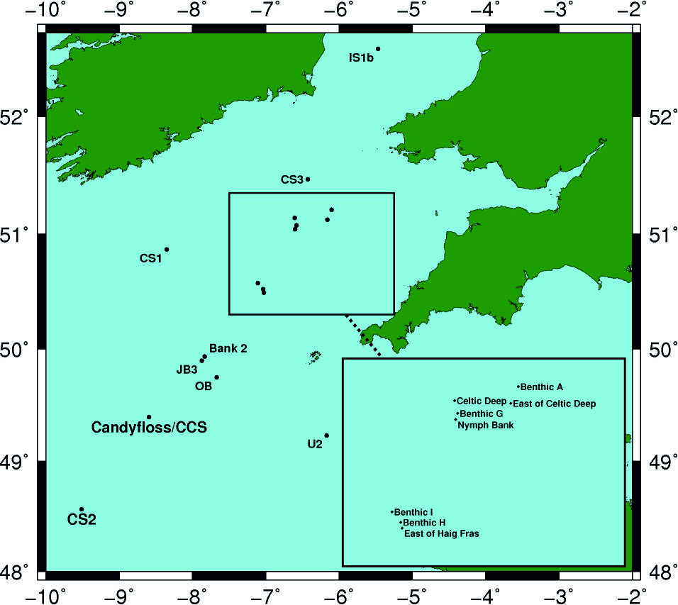
The following table describes which sites were visited during which cruises
| JB3 | Bank 2 | OB | IS1b | CS1 | CS2 | CS3 | U2 | Candyfloss/CCS | Benthic A | Benthic H | Benthic I | Benthic G | East of Haig Fras | Nymph Bank | Celtic Deep | East of Celtic Deep | |
|---|---|---|---|---|---|---|---|---|---|---|---|---|---|---|---|---|---|
| JR98 | - | - | - | X | X | X | X | X | - | - | - | - | - | - | - | - | - |
| CD173 | X | X | X | - | - | - | - | X | - | - | - | - | - | - | - | - | - |
| DY018 | - | - | - | - | - | X | - | - | X | X | X | X | X | X | X | X | X |
The deployment and sampling history, to date, for this station is summarised below:
Sampling History
| JR98 | CD173 | DY018 | |
|---|---|---|---|
| CTD casts | 30 | 15 | 15 |
| Free-fall light yo-yo profiles | - | 153 | - |
| Profiling radiometer | - | 16 | - |
| Zooplankton net hauls | - | - | 32 |
| Box cores | - | - | 5 |
| Marine snow catcher deployments | - | - | 17 |
| Stand Alone Pump Systems (SAPS) | - | - | 2 |
Mooring deployments
| Latitude | Longitude | Water depth (m) | Moored instrument | Deployment date | Recovery date | Deployment cruise | Recovery cruise | Comments |
|---|---|---|---|---|---|---|---|---|
| 48.532° | -9.463° | 200 | Surface temperature toroid | 2003-07-28 | 2003-08-12 | JR98 | JR98 | - |
| 48.532° | -9.463° | 200 | Thermistor chain throughout water column | 2003-07-28 | 2003-08-12 | JR98 | JR98 | - |
| 48.532° | -9.463° | 200 | Sub-surface 600 kHz ADCP | 2003-07-28 | 2003-08-12 | JR98 | JR98 | - |
| 48.532° | -9.463° | 200 | Aanderaa RCM7 current meter/CTD | 2003-07-28 | 2003-08-12 | JR98 | JR98 | - |
| 48.532° | -9.463° | 200 | Seabed frame 150 kHz ADCP | 2003-07-28 | 2003-08-12 | JR98 | JR98 | - |
| 48.532° | -9.463° | 200 | Seabed frame 300 kHz ADCP | 2003-07-28 | 2003-08-12 | JR98 | JR98 | - |
| 48.571° | -9.509° | 200 | Thermistor chain throughout water column | 2005-07-17 | 2005-07-24 | CD173 | CD173 | - |
| 48.573° | -9.51° | 194 | Sub-surface 300 kHz ADCP | 2005-07-17 | 2005-07-24 | CD173 | CD173 | - |
| 48.572° | -9.508° | 196 | Seabed frame 300 kHz ADCP | 2005-07-17 | 2005-07-24 | CD173 | CD173 | - |
| 48.571° | -9.507° | 202 | Seabed frame 150 kHz ADCP | 2005-07-17 | 2005-07-24 | CD173 | CD173 | - |
| - | - | 205 | T-F chain | 2014-11-17 09:03 UTC | 2014-11-19 17:07 UTC | DY018 | DY018 | - |
Related Fixed Station activities are detailed in Appendix 2
BODC Quality Control Flags
The following single character qualifying flags may be associated with one or more individual parameters with a data cycle:
| Flag | Description |
|---|---|
| Blank | Unqualified |
| < | Below detection limit |
| > | In excess of quoted value |
| A | Taxonomic flag for affinis (aff.) |
| B | Beginning of CTD Down/Up Cast |
| C | Taxonomic flag for confer (cf.) |
| D | Thermometric depth |
| E | End of CTD Down/Up Cast |
| G | Non-taxonomic biological characteristic uncertainty |
| H | Extrapolated value |
| I | Taxonomic flag for single species (sp.) |
| K | Improbable value - unknown quality control source |
| L | Improbable value - originator's quality control |
| M | Improbable value - BODC quality control |
| N | Null value |
| O | Improbable value - user quality control |
| P | Trace/calm |
| Q | Indeterminate |
| R | Replacement value |
| S | Estimated value |
| T | Interpolated value |
| U | Uncalibrated |
| W | Control value |
| X | Excessive difference |
SeaDataNet Quality Control Flags
The following single character qualifying flags may be associated with one or more individual parameters with a data cycle:
| Flag | Description |
|---|---|
| 0 | no quality control |
| 1 | good value |
| 2 | probably good value |
| 3 | probably bad value |
| 4 | bad value |
| 5 | changed value |
| 6 | value below detection |
| 7 | value in excess |
| 8 | interpolated value |
| 9 | missing value |
| A | value phenomenon uncertain |
| B | nominal value |
| Q | value below limit of quantification |
Appendix 1: DY018_CTD_135
Related series for this Data Activity are presented in the table below. Further information can be found by following the appropriate links.
If you are interested in these series, please be aware we offer a multiple file download service. Should your credentials be insufficient for automatic download, the service also offers a referral to our Enquiries Officer who may be able to negotiate access.
| Series Identifier | Data Category | Start date/time | Start position | Cruise |
|---|---|---|---|---|
| 2119856 | Water sample data | 2014-11-19 12:27:00 | 48.57112 N, 9.50949 W | RRS Discovery DY018 (GApr04) |
| 2126841 | Water sample data | 2014-11-19 12:27:00 | 48.57112 N, 9.50949 W | RRS Discovery DY018 (GApr04) |
| 2136651 | Water sample data | 2014-11-19 12:27:00 | 48.57112 N, 9.50949 W | RRS Discovery DY018 (GApr04) |
Appendix 2: CS2
Related series for this Fixed Station are presented in the table below. Further information can be found by following the appropriate links.
If you are interested in these series, please be aware we offer a multiple file download service. Should your credentials be insufficient for automatic download, the service also offers a referral to our Enquiries Officer who may be able to negotiate access.
| Series Identifier | Data Category | Start date/time | Start position | Cruise |
|---|---|---|---|---|
| 1106504 | CTD or STD cast | 2003-07-27 21:58:02 | 48.49983 N, 9.54967 W | RRS James Clark Ross JR20030725 (JR98) |
| 1106528 | CTD or STD cast | 2003-07-29 02:56:59 | 48.538 N, 9.46383 W | RRS James Clark Ross JR20030725 (JR98) |
| 1106541 | CTD or STD cast | 2003-07-29 03:58:02 | 48.538 N, 9.46417 W | RRS James Clark Ross JR20030725 (JR98) |
| 1106553 | CTD or STD cast | 2003-07-29 05:20:59 | 48.538 N, 9.46417 W | RRS James Clark Ross JR20030725 (JR98) |
| 1106565 | CTD or STD cast | 2003-07-29 06:01:00 | 48.538 N, 9.464 W | RRS James Clark Ross JR20030725 (JR98) |
| 1106577 | CTD or STD cast | 2003-07-29 06:58:02 | 48.538 N, 9.46417 W | RRS James Clark Ross JR20030725 (JR98) |
| 1106589 | CTD or STD cast | 2003-07-29 08:01:58 | 48.538 N, 9.464 W | RRS James Clark Ross JR20030725 (JR98) |
| 1106590 | CTD or STD cast | 2003-07-29 09:17:00 | 48.538 N, 9.46417 W | RRS James Clark Ross JR20030725 (JR98) |
| 1106608 | CTD or STD cast | 2003-07-29 10:22:57 | 48.538 N, 9.464 W | RRS James Clark Ross JR20030725 (JR98) |
| 1106621 | CTD or STD cast | 2003-07-29 11:15:04 | 48.53783 N, 9.464 W | RRS James Clark Ross JR20030725 (JR98) |
| 1106633 | CTD or STD cast | 2003-07-29 12:28:57 | 48.53783 N, 9.464 W | RRS James Clark Ross JR20030725 (JR98) |
| 1106645 | CTD or STD cast | 2003-07-29 13:37:03 | 48.53783 N, 9.464 W | RRS James Clark Ross JR20030725 (JR98) |
| 1106657 | CTD or STD cast | 2003-07-29 14:06:00 | 48.53783 N, 9.464 W | RRS James Clark Ross JR20030725 (JR98) |
| 1106669 | CTD or STD cast | 2003-07-29 15:00:00 | 48.538 N, 9.464 W | RRS James Clark Ross JR20030725 (JR98) |
| 1106670 | CTD or STD cast | 2003-07-29 16:12:00 | 48.538 N, 9.464 W | RRS James Clark Ross JR20030725 (JR98) |
| 1106682 | CTD or STD cast | 2003-07-29 17:00:58 | 48.538 N, 9.46417 W | RRS James Clark Ross JR20030725 (JR98) |
| 1106694 | CTD or STD cast | 2003-07-29 18:00:00 | 48.53783 N, 9.464 W | RRS James Clark Ross JR20030725 (JR98) |
| 1106701 | CTD or STD cast | 2003-07-29 18:58:02 | 48.53783 N, 9.46417 W | RRS James Clark Ross JR20030725 (JR98) |
| 1106713 | CTD or STD cast | 2003-07-29 19:59:57 | 48.53783 N, 9.46417 W | RRS James Clark Ross JR20030725 (JR98) |
| 1106725 | CTD or STD cast | 2003-07-29 20:57:59 | 48.53783 N, 9.464 W | RRS James Clark Ross JR20030725 (JR98) |
| 1106737 | CTD or STD cast | 2003-07-29 21:57:01 | 48.538 N, 9.464 W | RRS James Clark Ross JR20030725 (JR98) |
| 1106749 | CTD or STD cast | 2003-07-29 23:07:00 | 48.538 N, 9.46383 W | RRS James Clark Ross JR20030725 (JR98) |
| 1106750 | CTD or STD cast | 2003-07-29 23:56:59 | 48.53783 N, 9.464 W | RRS James Clark Ross JR20030725 (JR98) |
| 1106762 | CTD or STD cast | 2003-07-30 00:58:02 | 48.53783 N, 9.464 W | RRS James Clark Ross JR20030725 (JR98) |
| 1106774 | CTD or STD cast | 2003-07-30 01:57:04 | 48.53783 N, 9.464 W | RRS James Clark Ross JR20030725 (JR98) |
| 1106786 | CTD or STD cast | 2003-07-30 02:56:59 | 48.53833 N, 9.46317 W | RRS James Clark Ross JR20030725 (JR98) |
| 1106798 | CTD or STD cast | 2003-07-30 03:59:02 | 48.538 N, 9.464 W | RRS James Clark Ross JR20030725 (JR98) |
| 1106805 | CTD or STD cast | 2003-07-30 05:09:01 | 48.538 N, 9.464 W | RRS James Clark Ross JR20030725 (JR98) |
| 1108326 | CTD or STD cast | 2003-08-12 06:46:57 | 48.52383 N, 9.45533 W | RRS James Clark Ross JR20030725 (JR98) |
| 1108338 | CTD or STD cast | 2003-08-12 11:25:00 | 48.52883 N, 9.47533 W | RRS James Clark Ross JR20030725 (JR98) |
| 737376 | CTD or STD cast | 2005-07-17 18:57:00 | 48.575 N, 9.51433 W | RRS Charles Darwin CD173 |
| 737388 | CTD or STD cast | 2005-07-17 21:14:00 | 48.57517 N, 9.515 W | RRS Charles Darwin CD173 |
| 737407 | CTD or STD cast | 2005-07-17 23:07:00 | 48.57617 N, 9.51083 W | RRS Charles Darwin CD173 |
| 737419 | CTD or STD cast | 2005-07-18 00:58:00 | 48.57533 N, 9.50133 W | RRS Charles Darwin CD173 |
| 737420 | CTD or STD cast | 2005-07-18 07:19:00 | 48.568 N, 9.50233 W | RRS Charles Darwin CD173 |
| 1174790 | PAR radiance and irradiance | 2005-07-18 09:32:47 | 48.532 N, 9.463 W | RRS Charles Darwin CD173 |
| 1174808 | PAR radiance and irradiance | 2005-07-18 09:39:45 | 48.532 N, 9.463 W | RRS Charles Darwin CD173 |
| 737432 | CTD or STD cast | 2005-07-18 12:02:00 | 48.56817 N, 9.5115 W | RRS Charles Darwin CD173 |
| 1174821 | PAR radiance and irradiance | 2005-07-18 14:02:45 | 48.532 N, 9.463 W | RRS Charles Darwin CD173 |
| 1174833 | PAR radiance and irradiance | 2005-07-18 14:07:22 | 48.532 N, 9.463 W | RRS Charles Darwin CD173 |
| 737444 | CTD or STD cast | 2005-07-18 16:22:00 | 48.5705 N, 9.49217 W | RRS Charles Darwin CD173 |
| 737456 | CTD or STD cast | 2005-07-18 18:39:00 | 48.56867 N, 9.48233 W | RRS Charles Darwin CD173 |
| 737616 | CTD or STD cast | 2005-07-23 03:00:00 | 48.57167 N, 9.48967 W | RRS Charles Darwin CD173 |
| 737628 | CTD or STD cast | 2005-07-23 07:18:00 | 48.57083 N, 9.48733 W | RRS Charles Darwin CD173 |
| 1174845 | PAR radiance and irradiance | 2005-07-23 09:10:37 | 48.532 N, 9.463 W | RRS Charles Darwin CD173 |
| 1174857 | PAR radiance and irradiance | 2005-07-23 09:15:51 | 48.532 N, 9.463 W | RRS Charles Darwin CD173 |
| 1174869 | PAR radiance and irradiance | 2005-07-23 09:22:37 | 48.532 N, 9.463 W | RRS Charles Darwin CD173 |
| 737641 | CTD or STD cast | 2005-07-23 10:32:00 | 48.5785 N, 9.50317 W | RRS Charles Darwin CD173 |
| 737653 | CTD or STD cast | 2005-07-23 15:25:00 | 48.57733 N, 9.48133 W | RRS Charles Darwin CD173 |
| 1174870 | PAR radiance and irradiance | 2005-07-23 17:08:32 | 48.532 N, 9.463 W | RRS Charles Darwin CD173 |
| 1174882 | PAR radiance and irradiance | 2005-07-23 18:40:35 | 48.532 N, 9.463 W | RRS Charles Darwin CD173 |
| 737665 | CTD or STD cast | 2005-07-23 19:59:00 | 48.57617 N, 9.48967 W | RRS Charles Darwin CD173 |
| 737677 | CTD or STD cast | 2005-07-23 23:07:00 | 48.58083 N, 9.50617 W | RRS Charles Darwin CD173 |
| 737689 | CTD or STD cast | 2005-07-24 04:03:00 | 48.5825 N, 9.512 W | RRS Charles Darwin CD173 |
| 1371585 | CTD or STD cast | 2014-03-28 15:49:00 | 48.57113 N, 9.5127 W | RRS Discovery DY008 |
| 1336711 | Water sample data | 2014-03-28 15:55:00 | 48.57113 N, 9.5127 W | RRS Discovery DY008 |
| 2117548 | Water sample data | 2014-03-28 15:55:00 | 48.57113 N, 9.5127 W | RRS Discovery DY008 |
| 2119101 | Water sample data | 2014-03-28 15:55:00 | 48.57113 N, 9.5127 W | RRS Discovery DY008 |
| 1373057 | CTD or STD cast | 2014-08-07 06:04:00 | 48.57 N, 9.51 W | RRS Discovery DY026A |
| 2127506 | Water sample data | 2014-08-07 06:20:00 | 48.5699 N, 9.51027 W | RRS Discovery DY026A |
| 1373069 | CTD or STD cast | 2014-08-07 11:10:00 | 48.57633 N, 9.51617 W | RRS Discovery DY026A |
| 2118146 | Water sample data | 2014-08-07 11:29:30 | 48.57648 N, 9.5154 W | RRS Discovery DY026A |
| 2127518 | Water sample data | 2014-08-07 11:29:30 | 48.57648 N, 9.5154 W | RRS Discovery DY026A |
| 1373070 | CTD or STD cast | 2014-08-07 15:00:00 | 48.57167 N, 9.505 W | RRS Discovery DY026A |
| 2127531 | Water sample data | 2014-08-07 15:17:00 | 48.5711 N, 9.5046 W | RRS Discovery DY026A |
| 1371849 | CTD or STD cast | 2014-11-14 13:15:00 | 48.571 N, 9.50947 W | RRS Discovery DY018 (GApr04) |
| 2117689 | Water sample data | 2014-11-14 13:23:30 | 48.57106 N, 9.50945 W | RRS Discovery DY018 (GApr04) |
| 1749283 | Fluorescence or pigments | 2014-11-17 10:00:00 | 48.57086 N, 9.5097 W | RRS Discovery DY018 (GApr04) |
| 1749295 | Fluorescence or pigments | 2014-11-17 10:00:00 | 48.57086 N, 9.5097 W | RRS Discovery DY018 (GApr04) |
| 1749302 | Fluorescence or pigments | 2014-11-17 10:00:00 | 48.57086 N, 9.5097 W | RRS Discovery DY018 (GApr04) |
| 1749314 | Fluorescence or pigments | 2014-11-17 10:00:00 | 48.57086 N, 9.5097 W | RRS Discovery DY018 (GApr04) |
| 1749326 | Fluorescence or pigments | 2014-11-17 10:00:00 | 48.57086 N, 9.5097 W | RRS Discovery DY018 (GApr04) |
| 1749338 | Hydrography time series at depth | 2014-11-17 10:00:00 | 48.57086 N, 9.5097 W | RRS Discovery DY018 (GApr04) |
| 1749351 | Hydrography time series at depth | 2014-11-17 10:00:00 | 48.57086 N, 9.5097 W | RRS Discovery DY018 (GApr04) |
| 1749363 | Hydrography time series at depth | 2014-11-17 10:00:00 | 48.57086 N, 9.5097 W | RRS Discovery DY018 (GApr04) |
| 1749375 | Hydrography time series at depth | 2014-11-17 10:00:00 | 48.57086 N, 9.5097 W | RRS Discovery DY018 (GApr04) |
| 1749399 | Hydrography time series at depth | 2014-11-17 10:00:00 | 48.57086 N, 9.5097 W | RRS Discovery DY018 (GApr04) |
| 1749406 | Hydrography time series at depth | 2014-11-17 10:00:00 | 48.57086 N, 9.5097 W | RRS Discovery DY018 (GApr04) |
| 1749418 | Hydrography time series at depth | 2014-11-17 10:00:00 | 48.57086 N, 9.5097 W | RRS Discovery DY018 (GApr04) |
| 1749431 | Hydrography time series at depth | 2014-11-17 10:00:00 | 48.57086 N, 9.5097 W | RRS Discovery DY018 (GApr04) |
| 1749443 | Hydrography time series at depth | 2014-11-17 10:00:00 | 48.57086 N, 9.5097 W | RRS Discovery DY018 (GApr04) |
| 1749455 | Hydrography time series at depth | 2014-11-17 10:00:00 | 48.57086 N, 9.5097 W | RRS Discovery DY018 (GApr04) |
| 1749467 | Hydrography time series at depth | 2014-11-17 10:00:00 | 48.57086 N, 9.5097 W | RRS Discovery DY018 (GApr04) |
| 1749479 | Hydrography time series at depth | 2014-11-17 10:00:00 | 48.57086 N, 9.5097 W | RRS Discovery DY018 (GApr04) |
| 1749480 | Hydrography time series at depth | 2014-11-17 10:00:00 | 48.57086 N, 9.5097 W | RRS Discovery DY018 (GApr04) |
| 1749492 | Hydrography time series at depth | 2014-11-17 10:00:00 | 48.57086 N, 9.5097 W | RRS Discovery DY018 (GApr04) |
| 1749511 | Hydrography time series at depth | 2014-11-17 10:00:00 | 48.57086 N, 9.5097 W | RRS Discovery DY018 (GApr04) |
| 1749523 | Hydrography time series at depth | 2014-11-17 10:00:00 | 48.57086 N, 9.5097 W | RRS Discovery DY018 (GApr04) |
| 1749535 | Hydrography time series at depth | 2014-11-17 10:00:00 | 48.57086 N, 9.5097 W | RRS Discovery DY018 (GApr04) |
| 1749547 | Hydrography time series at depth | 2014-11-17 10:00:00 | 48.57086 N, 9.5097 W | RRS Discovery DY018 (GApr04) |
| 1749559 | Hydrography time series at depth | 2014-11-17 10:00:00 | 48.57086 N, 9.5097 W | RRS Discovery DY018 (GApr04) |
| 1749560 | Hydrography time series at depth | 2014-11-17 10:00:00 | 48.57086 N, 9.5097 W | RRS Discovery DY018 (GApr04) |
| 1749572 | Hydrography time series at depth | 2014-11-17 10:00:00 | 48.57086 N, 9.5097 W | RRS Discovery DY018 (GApr04) |
| 1749584 | Hydrography time series at depth | 2014-11-17 10:00:00 | 48.57086 N, 9.5097 W | RRS Discovery DY018 (GApr04) |
| 1749596 | Hydrography time series at depth | 2014-11-17 10:00:00 | 48.57086 N, 9.5097 W | RRS Discovery DY018 (GApr04) |
| 1749387 | Hydrography time series at depth | 2014-11-17 10:00:30 | 48.57086 N, 9.5097 W | RRS Discovery DY018 (GApr04) |
| 1371978 | CTD or STD cast | 2014-11-17 12:25:00 | 48.57087 N, 9.50968 W | RRS Discovery DY018 (GApr04) |
| 2117690 | Water sample data | 2014-11-17 12:35:30 | 48.57086 N, 9.50969 W | RRS Discovery DY018 (GApr04) |
| 2119832 | Water sample data | 2014-11-17 12:35:30 | 48.57086 N, 9.50969 W | RRS Discovery DY018 (GApr04) |
| 2126804 | Water sample data | 2014-11-17 12:35:30 | 48.57086 N, 9.50969 W | RRS Discovery DY018 (GApr04) |
| 2136614 | Water sample data | 2014-11-17 12:35:30 | 48.57086 N, 9.50969 W | RRS Discovery DY018 (GApr04) |
| 1371991 | CTD or STD cast | 2014-11-17 15:42:00 | 48.57087 N, 9.50968 W | RRS Discovery DY018 (GApr04) |
| 1372005 | CTD or STD cast | 2014-11-18 05:16:00 | 48.57107 N, 9.51052 W | RRS Discovery DY018 (GApr04) |
| 2117708 | Water sample data | 2014-11-18 05:28:00 | 48.57107 N, 9.51051 W | RRS Discovery DY018 (GApr04) |
| 2126816 | Water sample data | 2014-11-18 05:28:00 | 48.57107 N, 9.51051 W | RRS Discovery DY018 (GApr04) |
| 2136626 | Water sample data | 2014-11-18 05:28:00 | 48.57107 N, 9.51051 W | RRS Discovery DY018 (GApr04) |
| 1372017 | CTD or STD cast | 2014-11-18 08:10:00 | 48.57127 N, 9.51102 W | RRS Discovery DY018 (GApr04) |
| 1372460 | CTD or STD cast | 2014-11-18 09:15:00 | 48.57127 N, 9.51102 W | RRS Discovery DY018 (GApr04) |
| 2120058 | Water sample data | 2014-11-18 09:19:00 | 48.57127 N, 9.51102 W | RRS Discovery DY018 (GApr04) |
| 2121479 | Water sample data | 2014-11-18 09:19:00 | 48.57127 N, 9.51102 W | RRS Discovery DY018 (GApr04) |
| 2127033 | Water sample data | 2014-11-18 09:19:00 | 48.57127 N, 9.51102 W | RRS Discovery DY018 (GApr04) |
| 1372029 | CTD or STD cast | 2014-11-18 10:02:00 | 48.57127 N, 9.51102 W | RRS Discovery DY018 (GApr04) |
| 1372030 | CTD or STD cast | 2014-11-18 12:11:00 | 48.57123 N, 9.51103 W | RRS Discovery DY018 (GApr04) |
| 2117721 | Water sample data | 2014-11-18 12:21:30 | 48.57125 N, 9.51104 W | RRS Discovery DY018 (GApr04) |
| 2119844 | Water sample data | 2014-11-18 12:21:30 | 48.57125 N, 9.51104 W | RRS Discovery DY018 (GApr04) |
| 2126828 | Water sample data | 2014-11-18 12:21:30 | 48.57125 N, 9.51104 W | RRS Discovery DY018 (GApr04) |
| 2136638 | Water sample data | 2014-11-18 12:21:30 | 48.57125 N, 9.51104 W | RRS Discovery DY018 (GApr04) |
| 1372472 | CTD or STD cast | 2014-11-19 10:02:00 | 48.57112 N, 9.5095 W | RRS Discovery DY018 (GApr04) |
| 2120071 | Water sample data | 2014-11-19 10:06:00 | 48.57113 N, 9.50949 W | RRS Discovery DY018 (GApr04) |
| 2121480 | Water sample data | 2014-11-19 10:06:00 | 48.57113 N, 9.50949 W | RRS Discovery DY018 (GApr04) |
| 2127045 | Water sample data | 2014-11-19 10:06:00 | 48.57113 N, 9.50949 W | RRS Discovery DY018 (GApr04) |
| 1372042 | CTD or STD cast | 2014-11-19 12:17:00 | 48.57113 N, 9.50952 W | RRS Discovery DY018 (GApr04) |
| 2119856 | Water sample data | 2014-11-19 12:27:00 | 48.57112 N, 9.50949 W | RRS Discovery DY018 (GApr04) |
| 2126841 | Water sample data | 2014-11-19 12:27:00 | 48.57112 N, 9.50949 W | RRS Discovery DY018 (GApr04) |
| 2136651 | Water sample data | 2014-11-19 12:27:00 | 48.57112 N, 9.50949 W | RRS Discovery DY018 (GApr04) |
| 1372054 | CTD or STD cast | 2014-11-19 13:58:00 | 48.57112 N, 9.50953 W | RRS Discovery DY018 (GApr04) |
| 1372066 | CTD or STD cast | 2014-11-20 02:11:00 | 48.57352 N, 9.50627 W | RRS Discovery DY018 (GApr04) |
| 2117745 | Water sample data | 2014-11-20 02:21:30 | 48.57351 N, 9.50628 W | RRS Discovery DY018 (GApr04) |
| 2126853 | Water sample data | 2014-11-20 02:21:30 | 48.57351 N, 9.50628 W | RRS Discovery DY018 (GApr04) |
| 2136663 | Water sample data | 2014-11-20 02:21:30 | 48.57351 N, 9.50628 W | RRS Discovery DY018 (GApr04) |
| 1372238 | CTD or STD cast | 2014-11-24 13:17:00 | 48.571 N, 9.50945 W | RRS Discovery DY018 (GApr04) |
| 1372251 | CTD or STD cast | 2014-11-24 14:09:00 | 48.571 N, 9.50947 W | RRS Discovery DY018 (GApr04) |
| 2119893 | Water sample data | 2014-11-24 14:12:30 | 48.571 N, 9.50946 W | RRS Discovery DY018 (GApr04) |
| 1624461 | CTD or STD cast | 2015-03-24 05:51:00 | 48.57065 N, 9.5093 W | RRS Discovery DY021 |
| 2118091 | Water sample data | 2015-03-24 05:59:00 | 48.57066 N, 9.5093 W | RRS Discovery DY021 |
| 2127358 | Water sample data | 2015-03-24 05:59:00 | 48.57066 N, 9.5093 W | RRS Discovery DY021 |
| 1626271 | CTD or STD cast | 2015-04-09 02:07:00 | 48.57113 N, 9.51593 W | RRS Discovery DY029 (GApr04) |
| 1626283 | CTD or STD cast | 2015-04-09 07:07:00 | 48.57117 N, 9.50992 W | RRS Discovery DY029 (GApr04) |
| 1626258 | CTD or STD cast | 2015-04-09 18:06:00 | 48.5742 N, 9.50827 W | RRS Discovery DY029 (GApr04) |
| 2136780 | Water sample data | 2015-04-10 02:23:00 | 48.57114 N, 9.50994 W | RRS Discovery DY029 (GApr04) |
| 2118299 | Water sample data | 2015-04-10 07:25:00 | 48.57116 N, 9.5099 W | RRS Discovery DY029 (GApr04) |
| 1626523 | CTD or STD cast | 2015-04-17 07:09:00 | 48.57188 N, 9.51053 W | RRS Discovery DY029 (GApr04) |
| 2118411 | Water sample data | 2015-04-17 07:14:30 | 48.57057 N, 9.51103 W | RRS Discovery DY029 (GApr04) |
| 2136903 | Water sample data | 2015-04-17 07:14:30 | 48.57057 N, 9.51103 W | RRS Discovery DY029 (GApr04) |
| 2118472 | Water sample data | 2015-04-24 02:23:30 | 48.57129 N, 9.50945 W | RRS Discovery DY029 (GApr04) |
| 2136940 | Water sample data | 2015-04-24 02:23:30 | 48.57129 N, 9.50945 W | RRS Discovery DY029 (GApr04) |
| 1626812 | CTD or STD cast | 2015-04-24 02:41:00 | 48.57132 N, 9.50962 W | RRS Discovery DY029 (GApr04) |
| 1627378 | CTD or STD cast | 2015-04-24 05:43:00 | 48.52172 N, 9.45178 W | RRS Discovery DY029 (GApr04) |
| 1626824 | CTD or STD cast | 2015-04-24 09:04:00 | 48.60553 N, 9.44478 W | RRS Discovery DY029 (GApr04) |
| 2118484 | Water sample data | 2015-04-24 13:35:30 | 48.5697 N, 9.50944 W | RRS Discovery DY029 (GApr04) |
| 2136952 | Water sample data | 2015-04-24 13:35:30 | 48.5697 N, 9.50944 W | RRS Discovery DY029 (GApr04) |
| 1626836 | CTD or STD cast | 2015-04-24 13:49:00 | 48.56968 N, 9.50942 W | RRS Discovery DY029 (GApr04) |
| 1626848 | CTD or STD cast | 2015-04-24 15:45:00 | 48.5666 N, 9.50927 W | RRS Discovery DY029 (GApr04) |
| 1627391 | CTD or STD cast | 2015-04-24 16:27:00 | 48.56667 N, 9.50933 W | RRS Discovery DY029 (GApr04) |
| 1626861 | CTD or STD cast | 2015-04-24 17:25:00 | 48.56647 N, 9.50928 W | RRS Discovery DY029 (GApr04) |
| 1624983 | CTD or STD cast | 2015-05-22 14:55:00 | 48.57023 N, 9.5104 W | RRS Discovery DY030 |
| 2132545 | Water sample data | 2015-05-22 15:11:00 | 48.57023 N, 9.51038 W | RRS Discovery DY030 |
| 2137838 | Water sample data | 2015-05-22 15:11:00 | 48.57023 N, 9.51038 W | RRS Discovery DY030 |
| 1624645 | CTD or STD cast | 2015-05-22 16:13:00 | 48.57023 N, 9.5104 W | RRS Discovery DY030 |
| 2123413 | Water sample data | 2015-05-22 16:26:30 | 48.57023 N, 9.51039 W | RRS Discovery DY030 |
| 1625199 | CTD or STD cast | 2015-07-19 01:15:00 | 48.57085 N, 9.5098 W | RRS Discovery DY033 (GApr04) |
| 2118693 | Water sample data | 2015-07-19 01:21:30 | 48.57086 N, 9.5099 W | RRS Discovery DY033 (GApr04) |
| 2120279 | Water sample data | 2015-07-19 01:21:30 | 48.57086 N, 9.5099 W | RRS Discovery DY033 (GApr04) |
| 2123566 | Water sample data | 2015-07-19 01:21:30 | 48.57086 N, 9.5099 W | RRS Discovery DY033 (GApr04) |
| 2137931 | Water sample data | 2015-07-19 01:21:30 | 48.57086 N, 9.5099 W | RRS Discovery DY033 (GApr04) |
| 1625206 | CTD or STD cast | 2015-07-19 11:05:00 | 48.57113 N, 9.50987 W | RRS Discovery DY033 (GApr04) |
| 2123578 | Water sample data | 2015-07-19 11:17:00 | 48.57115 N, 9.50986 W | RRS Discovery DY033 (GApr04) |
| 2137943 | Water sample data | 2015-07-19 11:17:00 | 48.57115 N, 9.50986 W | RRS Discovery DY033 (GApr04) |
| 1625218 | CTD or STD cast | 2015-07-19 15:50:00 | 48.57122 N, 9.50985 W | RRS Discovery DY033 (GApr04) |
| 1625231 | CTD or STD cast | 2015-07-20 02:12:00 | 48.57083 N, 9.50967 W | RRS Discovery DY033 (GApr04) |
| 2118700 | Water sample data | 2015-07-20 02:24:00 | 48.57092 N, 9.50971 W | RRS Discovery DY033 (GApr04) |
| 2123591 | Water sample data | 2015-07-20 02:24:00 | 48.57092 N, 9.50971 W | RRS Discovery DY033 (GApr04) |
| 2137955 | Water sample data | 2015-07-20 02:24:00 | 48.57092 N, 9.50971 W | RRS Discovery DY033 (GApr04) |
| 1625685 | CTD or STD cast | 2015-07-20 03:29:00 | 48.57083 N, 9.50967 W | RRS Discovery DY033 (GApr04) |
| 2120440 | Water sample data | 2015-07-20 03:39:00 | 48.57093 N, 9.50975 W | RRS Discovery DY033 (GApr04) |
| 2123947 | Water sample data | 2015-07-20 03:39:00 | 48.57093 N, 9.50975 W | RRS Discovery DY033 (GApr04) |
| 1625243 | CTD or STD cast | 2015-07-20 05:18:00 | 48.57083 N, 9.50967 W | RRS Discovery DY033 (GApr04) |
| 1625255 | CTD or STD cast | 2015-07-20 10:04:00 | 48.5711 N, 9.5093 W | RRS Discovery DY033 (GApr04) |
| 2120280 | Water sample data | 2015-07-20 11:15:00 | 48.5711 N, 9.50929 W | RRS Discovery DY033 (GApr04) |
| 2123609 | Water sample data | 2015-07-20 11:15:00 | 48.5711 N, 9.50929 W | RRS Discovery DY033 (GApr04) |
| 2137967 | Water sample data | 2015-07-20 11:15:00 | 48.5711 N, 9.50929 W | RRS Discovery DY033 (GApr04) |
| 1625267 | CTD or STD cast | 2015-07-20 15:26:00 | 48.57107 N, 9.50897 W | RRS Discovery DY033 (GApr04) |
| 2119752 | Water sample data | 2015-08-31 08:42:30 | 48.57077 N, 9.50961 W | RRS Discovery DY034 |
| 2122317 | Water sample data | 2015-08-31 10:10:00 | 48.57082 N, 9.51127 W | RRS Discovery DY034 |
